Related Research Articles

Pleasanton is a city in Alameda County, California. Located in the Amador Valley, it is a suburb in the East Bay region of the Bay Area. The population was 70,285 at the 2010 census. In 2005 and 2007, Pleasanton was ranked the wealthiest middle-sized city in the United States by the Census Bureau. Pleasanton is home to the headquarters of Safeway, Workday, Ellie Mae, Roche Molecular Diagnostics, Blackhawk Network Holdings, and Veeva Systems. Other major employers include Kaiser Permanente, Oracle and Macy's. Although Oakland is the Alameda County seat, a few county offices are located in Pleasanton. The Alameda County Fairgrounds are located in Pleasanton, where the county fair is held during the last week of June and the first week of July. Pleasanton Ridge Regional Park is located on the west side of town.
A blind thrust earthquake occurs along a thrust fault that does not show signs on the Earth's surface, hence the designation "blind". Such faults, being invisible at the surface, have not been mapped by standard surface geological mapping. Sometimes they are discovered as a by-product of oil exploration seismology; in other cases their existence is not suspected.

The 1971 San Fernando earthquake occurred in the early morning of February 9 in the foothills of the San Gabriel Mountains in southern California. The unanticipated thrust earthquake had a magnitude of 6.5 on the Ms scale and 6.6 on the Mw scale, and a maximum Mercalli intensity of XI (Extreme). The event was one in a series that affected Los Angeles county in the late 20th century. Damage was locally severe in the northern San Fernando Valley and surface faulting was extensive to the south of the epicenter in the mountains, as well as urban settings along city streets and neighborhoods. Uplift and other effects affected private homes and businesses.

The Calaveras Fault is a major branch of the San Andreas Fault System that is located in northern California in the San Francisco Bay Area. Activity on the different segments of the fault includes moderate and large earthquakes as well as aseismic creep. The last large event was the 1984 Morgan Hill event and the last moderate earthquake was the 2007 Alum Rock event.

Arroyo Seco is an 11.7-mile-long (18.8 km) watercourse in Alameda County, California, that traverses through the city of Livermore, emptying into Arroyo Las Positas. Arroyo Seco means "dry stream" in Spanish. Arroyo Seco lies above the Arroyo Seco watershed, which includes the eastern part of the city of Livermore and also the Sandia National Laboratory. The Mocho Subbasin is the largest of the subbasins in the Livermore Valley watershed. This subbasin is bounded to the west by the Livermore Fault Zone and to the east by the Tesla Fault. Some groundwater flow occurs across these fault boundaries, but flows are discontinuous below a depth of 50 feet (15 m) across the Tesla Fault and south of the Arroyo Mocho channel across the Livermore Fault. A number of threatened and endangered species reside in this watershed.
The Mocho Subbasin is the largest of the groundwater subbasins in the Livermore Valley watershed in Northern California. This subbasin is bounded to the west by the Livermore Fault Zone and to the east by the Tesla Fault. Some groundwater flow occurs across these fault boundaries, but flows are discontinuous below a depth of fifty feet across the Tesla Fault and south of the Arroyo Mocho channel across the Livermore Fault. Surface watercourses in this unit include Arroyo Valle and Arroyo Seco.
The Tesla Fault can be found in the northeastern Diablo Range, California. This fault is only semi-active.
Arroyo Mocho is a 34.7-mile-long (55.8 km) stream which originates in the far northeastern corner of Santa Clara County and flows northwesterly into eastern Alameda County, California. After traversing the cities of Livermore and Pleasanton it joins South San Ramon Creek to become Arroyo de la Laguna, which in turn flows to Alameda Creek and thence to San Francisco Bay.

South San Ramon Creek is a 9.3-mile-long (15.0 km) southward-flowing stream in Alameda County and southern Contra Costa County, in the East Bay region of northern California.
The Bernal Subbasin is an aquifer located in the southwestern corner of Livermore Valley Groundwater Basin, Alameda County, California, United States. All of the groundwater in Livermore Valley moves toward the Bernal Subbasin, which is bounded on the east by Pleasanton Fault, on the north by the Park Fault, and on the west by the Calaveras Fault.(Earth Metrics, 1989) All the streams draining the Livermore Valley merge above the Bernal formation and exit this subbasin and Livermore Amador Valley via the Arroyo de la Laguna.

The San Jacinto Fault Zone (SJFZ) is a major strike-slip fault zone that runs through San Bernardino, Riverside, San Diego, and Imperial Counties in Southern California. The SJFZ is a component of the larger San Andreas transform system and is considered to be the most seismically active fault zone in the area. Together they relieve the majority of the stress between the Pacific and North American tectonic plates.
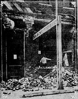
The 1868 Hayward earthquake occurred in the San Francisco Bay Area, California, United States on October 21. With an estimated moment magnitude of 6.3–6.7 and a maximum Mercalli intensity of IX (Violent), it was the most recent large earthquake to occur on the Hayward Fault Zone. It caused significant damage and a number of deaths throughout the region, and was known as the "Great San Francisco earthquake" prior to the 1906 San Francisco earthquake and fire.

The Ramapo Fault zone is a system of faults between the northern Appalachian Mountains and Piedmont areas to the east. Spanning more than 185 miles (298 km) in New York, New Jersey, and Pennsylvania, it is perhaps the best known fault zone in the Mid-Atlantic region, and some small earthquakes have been known to occur in its vicinity. Recently, public knowledge about the fault has increased, especially after the 1970s, when the fault's proximity to the Indian Point nuclear plant in New York was noted.
The Brawley Seismic Zone (BSZ), also known as the Brawley fault zone, is a predominantly extensional tectonic zone that connects the southern terminus of the San Andreas Fault with the Imperial Fault in Southern California. The BSZ is named for the nearby town of Brawley in Imperial County, California, and the seismicity there is characterized by earthquake swarms.
The 1940 El Centro earthquake occurred at 21:35 Pacific Standard Time on May 18 in the Imperial Valley in southeastern Southern California near the international border of the United States and Mexico. It had a moment magnitude of 6.9 and a maximum perceived intensity of X (Extreme) on the Mercalli intensity scale. It was the first major earthquake to be recorded by a strong-motion seismograph located next to a fault rupture. The earthquake was characterized as a typical moderate-sized destructive event with a complex energy release signature. It was the strongest recorded earthquake to hit the Imperial Valley, and caused widespread damage to irrigation systems and led to the deaths of nine people.

The 1892 Laguna Salada earthquake occurred at 23:20 Pacific Standard Time on February 23. It had an estimated moment magnitude of 7.1–7.2 and a maximum perceived intensity of VIII (Severe). The shock was centered near the Mexico–United States border and takes its name from a large dry lake bed in Baja California, Mexico. There were no reported casualties, but the event affected the then largely-uninhabited areas of northern Mexico and Southern California.
The 1979 Imperial Valley earthquake occurred at 16:16 Pacific Daylight Time on 15 October just south of the Mexico–United States border. It affected Imperial Valley in Southern California and Mexicali Valley in northern Baja California. The earthquake had a relatively shallow hypocenter and caused property damage in the United States estimated at US$30 million. The irrigation systems in the Imperial Valley were badly affected, but no deaths occurred. It was the largest earthquake to occur in the contiguous United States since the 1971 San Fernando earthquake eight years earlier.
The 1892 Vacaville–Winters earthquakes occurred in northern California as a large doublet on April 19 and April 21. Measured on a seismic scale that is based on an isoseismal map or the event's felt area, the 6.4 Mla and 6.2 Mla events were assigned a maximum Mercalli intensity of IX (Violent), and affected the North Bay and Central Valley areas. The total damage was estimated to be between $225,000 and 250,000 and one person was killed. No evidence of fault movement on the surface of the ground was observed as a result of either of the strong shocks. Both occurred in the domain of the San Andreas strike-slip system of faults, but their focal mechanism is uncertain.
The 1918 San Jacinto earthquake occurred in extreme eastern San Diego County in Southern California on April 21 at 14:32:29 local time. The shock had a moment magnitude of 6.7 and a maximum Mercalli intensity of IX (Violent). Several injuries and one death occurred with total losses estimated to be $200,000.
The 1968 Borrego Mountain earthquake occurred on the evening of April 8, near the unincorporated community of Ocotillo Wells in San Diego County. The moment magnitude 6.6 earthquake was assigned a maximum intensity of VII or IX (Violent) on the Mercalli intensity scale, causing some damage in the Imperial Valley, but no injuries or deaths. Shaking from this earthquake was widely felt, even in Nevada, and Arizona. It was the largest earthquake in Southern California since the 1952 Kern County earthquake 16 years prior.
References
- ↑ "Seismic Safety Element of the Alameda County General Plan" (Archived OCR of original). Alameda County. 1982. Archived from the original on 2012-12-11. Retrieved 2018-02-24.
- ↑ Berlogar, Stevens, and Associates. (March 27, 2013). "Fault Ground-Rupture Investigation Proposed Dublin Crossing Mixed Use Development, Camp Parks Reserve Forces Training Area, Dublin CA". City of Dublin, California. Retrieved 2021-07-25.
Based on the findings from the above fault investigations, there is no substantiated evidence for the existence of the inferred Pleasanton Fault traces shown on the current A-P Earthquake Fault Zone Map
CS1 maint: multiple names: authors list (link) - ↑ Earth Metrics Incorporated, ‘'Environmental Site Assessment for the Hopyard Village Shopping Center, Pleasanton, California'‘, May 24, 1989