Point Hueneme Light

Last updated
Point Hueneme Light
Point Hueneme Lighthouse.jpg
Point Hueneme Lighthouse in 2009
Point Hueneme Light
LocationPoint Hueneme
Port Hueneme
California
United States
Coordinates 34°08′43″N119°12′36″W / 34.145176°N 119.210019°W / 34.145176; -119.210019 Coordinates: 34°08′43″N119°12′36″W / 34.145176°N 119.210019°W / 34.145176; -119.210019
Tower
Constructed1874 (first)
Constructionconcrete tower
Automated1972
Height48 ft (15 m)
Shapesquare tower with balcony and lantern on fog signal building
Markingsart deco architecture,
white tower, red lantern
OperatorUnited States Coast Guard [1] [2]
Light
First lit1941 (current)
Focal height52 ft (16 m)
LensFourth order Fresnel lens (original), LED light (current)
Range20 nmi (37 km; 23 mi)  OOjs UI icon edit-ltr-progressive.svg
Characteristic Fl W 5s.

Point Hueneme Lighthouse is a lighthouse on the southeast entrance to the Santa Barbara Channel, in Ventura County, California [3]

Contents

History

Original 1874 Lighthouse by Paul J. Pelz, USCG photo USCGpointhuenemeOld.JPG
Original 1874 Lighthouse by Paul J. Pelz, USCG photo

Point Hueneme Light is a 48-foot-high (15 m), buff-colored 1940 Art Deco style tower on a fog-signal building on the Santa Barbara Channel at the Port of Hueneme.

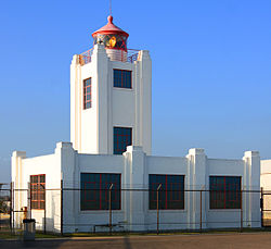
The original lighthouse was completed in 1874 at Point Hueneme [4] after the construction of a 900-foot-long wharf (270 m) in 1872. [note 1] When a storm destroyed the wharf in 1938, Oxnard Harbor District was formed and finished construction of the Port of Hueneme in 1940. The extant lighthouse structure was completed in 1941. The fourth-order Fresnel lens was used in both the original and the current lighthouse towers until 2013. In November 2012, the Ventura County Cultural Heritage Board voted to preserve the 1899 lens by retiring it from active service, so it can be displayed on a lower floor of the lighthouse and more easily viewed by the public. [5] The original 1874 lighthouse was designed by Paul J. Pelz, who also designed Point Hueneme's sister stations, Point Fermin Light in San Pedro CA, East Brother Island Light in Richmond, California, Mare Island Light, in Carquinez Strait, California (demolished in the 1930s), Hereford Inlet Light in North Wildwood, New Jersey, and Point Adams Light in Washington State (burned down by the Lighthouse Service in 1912), all in essentially the same style.

Shipwreck

Point Hueneme Light was the site of an unrelated shipwreck. The veteran passenger liner La Jenelle , once removed from her role as a cruise liner, lay at anchor off Port Hueneme on April 14, 1970 awaiting plans for conversion to a floating restaurant. The owners were attempting to cut down on moorage costs by leaving the vessel at anchor in the open ocean, directly offshore. With only one watchman aboard, the vessel fell victim to storm-tossed seas, causing the 465-foot-long (142 m) ship to slip her anchor cables. The California State Lands Commission became much concerned about the problem both from the standpoint of leaking oil and a menace to navigation. They voted unanimously to have the ship scrapped, "as is, where is," and accordingly put out bids. The big steel ship still remains but is being torn apart bit by bit by human and natural elements.

Lighthouse tours

The lighthouse is federal property operated by the United States Coast Guard. The U.S. Coast Guards Aids to Navigation Team Los Angeles/Long Beach(CG ANT LA/LB) is in charge of operation and maintenance of the lighthouse and Fresnel Lens. Members from the U.S. Coast Guard Auxiliary, who are also members of the CG ANT LA/LB, are in charge of the tour and openhouse at the lighthouse. These members are recognized as Lighthouse Keepers by the USCG Auxiliary and Technicians by the CG.

In March 2008, the City of Port Hueneme and Oxnard Harbor District dedicated a new "Lighthouse Promenade", beginning at the Hueneme Sunset Beach alongside the perimeter fence of the port to the lighthouse. The 1/2 mile stroll is on a flat, even surface and allows visitors to stroll along the beach. There are no public restrooms on property, the nearest public restrooms are at the promenade's entrance at Sunset Beach. [6] [7]

See also

Notes

  1. Later lengthened to 1,500-foot-long (460 m)

Related Research Articles

<span class="mw-page-title-main">Port Hueneme, California</span> City in the state of California, United States

Port Hueneme is a small beach city in Ventura County, California, surrounded by the city of Oxnard and the Santa Barbara Channel. Both the Port of Hueneme and Naval Base Ventura County lie within the city limits.

<span class="mw-page-title-main">West Point Light</span> Lighthouse in Seattle, Washington, U.S.

The West Point Light, also known as the Discovery Park Lighthouse, is an active aid to navigation on Seattle, Washington's West Point, which juts into Puget Sound and marks the northern extent of Elliott Bay. The lighthouse is similar in design to the Point No Point Light and was added to the National Register of Historic Places in 1977. It is a main feature of Seattle's Discovery Park.

<span class="mw-page-title-main">Point Wilson Light</span> Lighthouse

The Point Wilson Light is an active aid to navigation located in Fort Worden State Park near Port Townsend, Jefferson County, Washington. It is one of the most important navigational aids in the state, overlooking the entrance to Admiralty Inlet, the waterway connecting the Strait of Juan de Fuca and Puget Sound. The lighthouse was listed on the Washington State Heritage Register and the National Register of Historic Places in 1971.

<span class="mw-page-title-main">East Brother Island Light</span> Lighthouse in California, United States

East Brother Island Lighthouse is a lighthouse located on East Brother Island in San Rafael Bay, near the tip of Point San Pablo in Richmond, California. It marks the entrance to San Pablo Bay from San Francisco Bay.

<span class="mw-page-title-main">Alki Point Light</span> Lighthouse

The Alki Point Light is an active aid to navigation located on Puget Sound's Alki Point, the southern entrance to Seattle's Elliott Bay, King County, Washington. It is listed as Alki Point Light number 16915 in the USCG light lists.

<span class="mw-page-title-main">Point No Point Light (Washington)</span> Lighthouse in Washington, United States

Point No Point Light is an operational aid to navigation on the northeastern tip of the Kitsap Peninsula on the west side of Puget Sound, at Point No Point where Admiralty Inlet joins Puget Sound, near the small community of Hansville, Kitsap County, in the U.S. state of Washington. Point No Point Light is considered the oldest lighthouse on Puget Sound and is listed on the National Register of Historic Places.

<span class="mw-page-title-main">Point Robinson Light</span> Lighthouse

The Point Robinson Light is an operational aid to navigation and historic lighthouse on Puget Sound, located at Point Robinson, the easternmost point of Maury Island, King County, in the U.S. state of Washington. The site was listed on the National Register of Historic Places in 2004.

<span class="mw-page-title-main">Silver Strand Beach</span>

Silver Strand Beach is an unincorporated beach neighborhood in Ventura County, California, United States. Lying between the mouth of Channel Islands Harbor on the north and the ocean entrance to the Port of Hueneme on the south, the eastern side of the beach community lies along the boundary of the Naval Construction Battalion Center Port Hueneme. The harbors and the Naval base almost completely surround Silver Strand, keeping the area relatively separate from the city of Oxnard and making it accessible by only one main road, Victoria Avenue.

<span class="mw-page-title-main">Farallon Island Light</span> Lighthouse in California, United States

Farallon Island Light is a lighthouse on Southeast Farallon Island, California. One of the highest lights in California, it was constructed in 1855 to warn ships approaching San Francisco from the west away from the rocky islands. In later years it was shorn of its lantern, but it remains in use.

<span class="mw-page-title-main">Point Bonita Lighthouse</span> Lighthouse at Point Bonita at the San Francisco Bay entrance, California, US

Point Bonita Lighthouse is a lighthouse located at Point Bonita at the San Francisco Bay entrance in the Marin Headlands near Sausalito, California. Point Bonita was the last manned lighthouse on the California coast. It was added to the National Register of Historic Places in 1991.

<span class="mw-page-title-main">Point Vicente Lighthouse</span> Lighthouse in California, United States

Point Vicente Lighthouse is a lighthouse in Rancho Palos Verdes, California, United States, north of Los Angeles Harbor. It is 67 feet (20 m) tall and stands on a cliff with a height of 130 feet (40 m). It is between Point Loma Lighthouse to the south and Point Conception Lighthouse to the north. The lighthouse was added to the National Register of Historic Places in 1980. The lighthouse is owned by the United States federal government and is managed by the United States Coast Guard. It is not usually open to the public, but the Coast Guard Auxiliary run tours once per month and it is used annually for the city's "Whale of a Day" festival.

<span class="mw-page-title-main">Stratford Point Light</span> Lighthouse

Stratford Point Light is a historic lighthouse in Stratford, Connecticut, United States, at the mouth of the Housatonic River. The second tower was one of the first prefabricated cylindrical lighthouses in the country and remains active.

<span class="mw-page-title-main">Point San Luis Lighthouse</span> Lighthouse on the National Register of Historic Places in California

The Point San Luis Lighthouse, also known as the San Luis Obispo Light Station, is on the National Register of Historic Places. Located near Avila Beach on the Central Coast of California in San Luis Obispo County, it is the only Prairie Victorian model lighthouse left on the West Coast of the United States. It is being refurbished by the Point San Luis Lighthouse Keepers, a volunteer group.

<span class="mw-page-title-main">Turkey Point Light</span> Lighthouse in Maryland, United States

The Turkey Point Light is a historic lighthouse at the head of the Chesapeake Bay. Although only a 35-foot (11 m) tower, the 100-foot (30 m) height of the bluffs on which it stands makes it the third highest light off the water in the bay. It is also known for the large number of women who served as lightkeeper.

<span class="mw-page-title-main">Point Sur Lighthouse</span> Lighthouse in California, United States

Point Sur Lighthouse is a lightstation at Point Sur 24.6 miles (39.6 km) south of Monterey, California at the peak of the 361-foot (110 m) rock at the head of the point. It was established in 1889 and is part of Point Sur State Historic Park. The light house is 40 feet (12 m) tall and 270 feet (82 m) above sea level. As of 2016, and for the foreseeable future the light is still in operation as an essential aid to navigation. Point Sur is the only complete turn-of-the-20th-century lightstation open to the public in California. Three-hour walking tours guided by volunteers are available on Wednesdays and weekends throughout the year.

<span class="mw-page-title-main">Staten Island Light</span> Lighthouse

The Staten Island Range Light, also known as the Ambrose Channel Range Light, is the rear range light companion to the West Bank Lighthouse. Built in 1912, the 90-foot tower sits more than five miles northwest of the West Bank Lighthouse, on Staten Island’s Richmond Hill, 141 feet above sea level. It shows a fixed white light that can be seen for 18 miles, by all vessels bound to New York and New Jersey Ports coming in from the Atlantic Ocean.

<span class="mw-page-title-main">Mayo Beach Light</span> Lighthouse

The Mayo Beach Light was an early lighthouse on Cape Cod. Deactivated in 1922, the second tower was moved to California and re-erected as the Point Montara Light in 1928.

<span class="mw-page-title-main">Owls Head Light</span> Lighthouse in Maine, US

The Owls Head Light is an active aid to navigation located at the entrance of Rockland Harbor on western Penobscot Bay in the town of Owls Head, Knox County, Maine. The lighthouse is owned by the U.S. Coast Guard and licensed to the American Lighthouse Foundation. It is the centerpiece of 13-acre (5.3 ha) Owls Head State Park and was added to the National Register of Historic Places as Owls Head Light Station in 1978.

<span class="mw-page-title-main">Pigeon Point Lighthouse</span> Historic lighthouse in California, United States

Pigeon Point Light Station or Pigeon Point Lighthouse is a lighthouse built in 1871 to guide ships on the Pacific coast of California. It is the tallest lighthouse on the West Coast of the United States. It is still an active Coast Guard aid to navigation. Pigeon Point Light Station is located on the coastal highway, 5 miles (8 km) south of Pescadero, California, between Santa Cruz and San Francisco. The 115-foot (35 m), white masonry tower, resembles the typical New England structure.

<span class="mw-page-title-main">Port of Hueneme</span> Commercial and military port in Ventura County, California

The Port of Hueneme in the city of Port Hueneme, California, United States, is the only deep water harbor between Los Angeles and the San Francisco Bay area. Located in Ventura County on the Santa Barbara Channel, the port complex not only serves international shipping businesses but is an operating facility of Naval Base Ventura County (NBVC).

References

  1. Rowlett, Russ. "Lighthouses of the United States: Central and Southern California". The Lighthouse Directory. University of North Carolina at Chapel Hill . Retrieved 2016-06-13.
  2. California Historic Light Station Information & Photography United States Coast Guard. Retrieved 13 June 2016
  3. Map showing "light house reservation" October 1, 1888. 3 MR 13. Ventura County Recorder Retrieved September 8, 2014 from CountyView GIS Archived 2014-09-25 at the Wayback Machine .
  4. U.S. Geological Survey Geographic Names Information System: Point Hueneme
  5. "Lighthousefriends.com - Point Hueneme Light".
  6. "Huenemelight.org". Archived from the original on 2021-09-02. Retrieved 2022-07-15.
  7. Klampe, Michelle L. (March 21, 2008) "Waterfront Promenade officially opens today" Ventura County Star