Anacapa Island Light

Last updated

Anacapa Island Light
Anacapa-lighthouse.jpg
Anacapa Island Light
Location Anacapa Island
Ventura County
California
United States
Coordinates 34°00′57″N119°21′34″W / 34.015827°N 119.359548°W / 34.015827; -119.359548
Tower
Constructed1912 (first)
Foundationbrick and concrete base
Constructionreinforced concrete tower
Automated1968
Height55 feet (17 m)
Shapecylindrical tower with balcony and lantern
Markingswhite tower,
black lantern
Power sourcesolar power  OOjs UI icon edit-ltr-progressive.svg
OperatorChannel Islands National Park [1] [2]
HeritageNational Register of Historic Places listed place  OOjs UI icon edit-ltr-progressive.svg
Fog signal blast every 15s.
Light
First lit1932 (current)
Focal height277 feet (84 m)
LensThird order Fresnel lens (original), DCB-24 aerobeacon (current)
Range20 nmi (37 km; 23 mi)  OOjs UI icon edit-ltr-progressive.svg
Characteristic Fl (2) W 60s.
Anacapa Island Light Station
Nearest city Oxnard, California
Area40 acres (16 ha)
Built1932
ArchitectLippman, M.W.
Architectural styleMission/spanish Revival
MPS Light Stations of California MPS
NRHP reference No. 91001101 [3]  (original)
100010729  (increase)
Significant dates
Added to NRHPSeptember 3, 1991
Boundary increaseAugust 22, 2024

Anacapa Island Lighthouse is a lighthouse in California, United States, on the entrance to Santa Barbara Channel, California. Constructed in 1912, it was the last major light station built on the west coast. Anacapa and several other islands were collectively designated as Channel Islands National Monument in 1938, though the Coast Guard retained responsibility for the Anacapa lighthouse. Now fully automated and unmanned, the light house still operates, but the National Park Service (NPS) is responsible for Channel Islands National Park.

Contents

Anacapa Island is noted now for an environmental restoration program devised by the NPS to exterminate the large population of non-native rats which infested the island and was making significant inroads on native species. The program, which began in 2003, selectively killed off the invaders with few adverse effects on the non-targeted native wildlife species. By 2014, after careful examination of the island, NPS could declare it rat-free.

History

Positioned at the eastern entrance to the Santa Barbara Channel, Anacapa was a natural choice for a lighthouse. The Lighthouse Board decided to place a light on the island, but to limit the expense of building an offshore beacon, an unmanned acetylene lens lantern on a tower was erected in 1912. In 1932, the current permanent light station was built on the island, and was the last major light station to be built on the west coast. The 39-foot (12 m) tower and fog signal were built on the highest point of the island. In 1938, under the direction of Franklin D. Roosevelt, Santa Barbara and Anacapa Islands became Channel Islands National Monument. The United States Coast Guard automated the station in 1966. In 1980, Congress designated five of the eight Channel Islands, Anacapa, Santa Cruz, Santa Rosa, San Miguel, and Santa Barbara Islands, and 125,000 acres (51,000 ha) of submerged lands as Channel Islands National Park. The lighthouse is still an active aid to navigation.

Historical Information from Coast Guard web site: [4]

Anacapa, a native-American word meaning "ever changing", was first discovered by Juan Rodríguez Cabrillo in 1542. The islands were called Las Mesitas or the Little Tables by De Portola in 1769. Captain George Vancouver renamed them Anacapa from the Canalino Indian name of Enecapah. Anacapa Island is really a chain of three small islets extending four and a half miles from east to west. The easternmost island is one mile (1.6 km) long, a quarter of a mile wide, and rises 250 feet (76 m) above the water. Middle Island is one and a half miles long, a quarter of a mile wide and 325 feet (99 m) at its highest point. The western, and largest island of this group, is two miles (3 km) long by six tenths of a mile wide, and rises to a peak of 930 feet (280 m). Anacapa’s 40-foot (12 m) lighthouse tower and adjacent foghorn building are located on East Anacapa. Her radiant 1.1 million candlepower light beacon, her bellowing foghorn and beeping radio signal have guided ships safely through the coastal channel since 1932, the date of construction. Prior to that an unattended light placed on the island in 1912 served as a guiding beacon for sailing vessels. A one tenth second of white light, 11-9/10 second of darkness, one-tenth second of light, 11-9/10 second of darkness, one tenth second of light, 35.9 seconds of darkness. This is the visual voice of Anacapa Island Light Station. The foghorn, a diaphragm-type horn, groans one two second blast then is silent for two seconds, blasts again for two seconds and then completes the cycle with 14 seconds of silence during low visibility. Electronic equipment sends out a continual radio beacon signal with a range of 12 miles (19 km). The Coast Guardsmen and their families of the light station resided in the four large Spanish style white stucco houses with red tile roofs before the light station was automated in December, 1968.

Current usage

The buildings other than the lighthouse are now being utilized by the National Park Service.

Geography

Anacapa is the smallest and the nearest of the Channel Islands to the mainland. It is 9 miles (14 km) across the Santa Barbara Channel from the nearest point on the mainland. It lies southwest of the city of Ventura. [5]

See also

Related Research Articles

<span class="mw-page-title-main">Anacapa Island</span> Island of the Channel Islands in California, United States

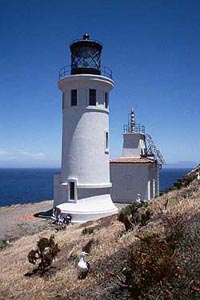
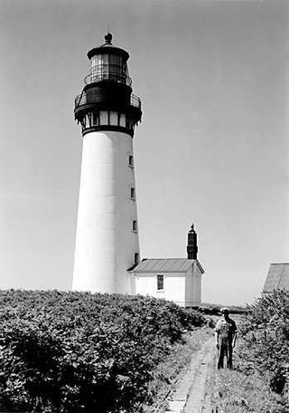
Anacapa Island is a small volcanic island located about 11 miles off Port Hueneme in Ventura County, California. The island is composed of a series of narrow islets 6 mi (10 km) long, oriented generally east–west and 5 mi (8 km) east of Santa Cruz Island. The three main islets, East, Middle and West Anacapa, have precipitous cliffs, dropping off steeply into the sea.

<span class="mw-page-title-main">Channel Islands National Park</span> National park in California, United States

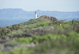
Channel Islands National Park consists of five of the eight Channel Islands off the Pacific coast of the U.S. state of California. Although the islands are close to the shore of the densely populated state, they have been relatively undeveloped. The park covers 249,561 acres (100,994 ha), of which 79,019 acres (31,978 ha) are federal land.

<span class="mw-page-title-main">Santa Barbara Island</span> Island of the Channel Islands in California, United States

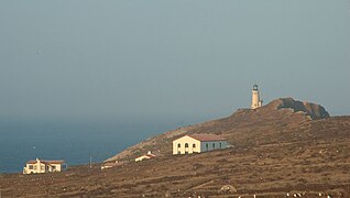
Santa Barbara Island is a small island of the Channel Islands archipelago in Southern California. It is protected within Channel Islands National Park, and its marine ecosystem is part of the Channel Islands National Marine Sanctuary. Public passenger access to Santa Barbara Island is provided by the Island Packers ferry service.

<span class="mw-page-title-main">Marblehead Light (Ohio)</span> Lighthouse in Ohio, US

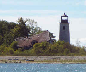
Marblehead Lighthouse in Marblehead, Ohio, United States, is the oldest lighthouse in continuous operation on the American side of the Great Lakes. It has guided sailors safely along the rocky shores of Marblehead Peninsula since 1822, and is an active aid to navigation.

<span class="mw-page-title-main">Point Pinos Lighthouse</span> 19th century lighthouse in Pacific Grove, California

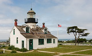
Point Pinos Lighthouse was lit on February 1, 1855, to guide ships on the Pacific Coast of California. It is the oldest continuously operating lighthouse on the West Coast of the United States and even the lens is original. Alcatraz Island Lighthouse preceded Point Pinos by eight months, but was replaced in 1909 by the expanding military prison. The Point Pinos Lighthouse is still an active United States Coast Guard aid to navigation. On-site museum exhibits and other lighthouse related functions are operated by the city of Pacific Grove, Monterey County, California. The lighthouse is surrounded by the Pacific Grove Municipal Golf Links.

<span class="mw-page-title-main">Wood Island Light</span> Lighthouse in Maine, US

Wood Island Light is an active lighthouse on the eastern edge of Wood Island in Saco Bay, on the southern coast of Maine. The light is just outside the entrance to Biddeford Pool and the end of the Saco River. The lighthouse is a 47-foot (14 m) conical white tower of granite rubble. The light itself sits 71 feet (22 m) above mean high water. Its automated beacon alternates between green and white every 10 seconds.

<span class="mw-page-title-main">East Brother Island Light</span> Lighthouse in California, United States

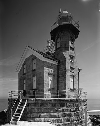
East Brother Island Lighthouse is a lighthouse located on East Brother Island in San Rafael Bay, near the tip of Point San Pablo in Richmond, California. It marks the entrance to San Pablo Bay from San Francisco Bay.

<span class="mw-page-title-main">Gravelly Shoal Light</span> Lighthouse in Michigan, United States

Gravelly Shoals Light is an automated lighthouse that is an active aid to navigation on the shallow shoals extending southeast from Point Lookout on the western side of Saginaw Bay. The light is situated about 2.7 miles (4.3 km) offshore and was built to help guide boats through the deeper water between the southeast end of Gravelly Shoals and Charity Island. Architecturally this is considered to be Art Deco style.

<span class="mw-page-title-main">Destruction Island Light</span> Lighthouse in Washington, U.S.

Destruction Island Lighthouse is a decommissioned lighthouse on Destruction Island, a rocky island that is part of the Quillayute Needles National Wildlife Refuge lying about 3 miles (4.8 km) off the coast of Jefferson County, Washington, in the northwest of the United States.

<span class="mw-page-title-main">Lime Kiln Light</span> Lighthouse

The Lime Kiln Light is a functioning navigational aid located on Lime Kiln Point overlooking Dead Man's Bay on the western side of San Juan Island, San Juan County, Washington, in the United States. It guides ships through the Haro Straits and is part of Lime Kiln Point State Park, which offers tours during summer months.

<span class="mw-page-title-main">Alcatraz Island Lighthouse</span> Lighthouse in the San Francisco Bay, California

Alcatraz Island Lighthouse is a lighthouse—the first one built on the U.S. West Coast—located on Alcatraz Island in California's San Francisco Bay. It is located at the southern end of the island near the entrance to the prison. The first light house on the island was completed in 1854, and served the bay during its time as a Citadel and military prison. It was replaced by a taller concrete tower built in 1909 to the south of the original one which was demolished after it was damaged due to earthquake in 1906. The automation of the lighthouse with a modern beacon took place in 1963, the year Alcatraz closed as the Alcatraz Federal Penitentiary. It is the oldest light station on the island with a modern beacon and is part of the museum on the island. Although when viewed from afar it easily looks the tallest structure on Alcatraz, it is actually shorter than the Alcatraz Water Tower, but as it lies on higher ground it looks much taller.

<span class="mw-page-title-main">Charity Island Light</span> Lighthouse in Michigan, United States

Charity Island Light is a lighthouse on Big Charity Island in Lake Huron just off the coast of Au Gres, Northern Michigan.

<span class="mw-page-title-main">Point Cabrillo Light</span> Lighthouse in northern California

Point Cabrillo Light is a lighthouse in northern California, United States, between Point Arena and Cape Mendocino, just south of the community of Caspar. It has been a federal aid to navigation since 1909. It is part of the California state park system as Point Cabrillo Light Station State Historic Park.

<span class="mw-page-title-main">Point Conception Light</span> Lighthouse in Santa Barbara County, California

Point Conception Light is a lighthouse in Santa Barbara County, California, on Point Conception at the west entrance of the Santa Barbara Channel, California. One of the earliest California lighthouses, it is listed on the National Register of Historic Places on the Gaviota Coast.

<span class="mw-page-title-main">Point Vicente Lighthouse</span> Lighthouse in California, United States

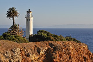
Point Vicente Lighthouse is a lighthouse in Rancho Palos Verdes, California, United States, north of Los Angeles Harbor. It is 67 feet (20 m) tall and stands on a cliff with a height of 130 feet (40 m). It is between Point Loma Lighthouse to the south and Point Conception Lighthouse to the north. The lighthouse was added to the National Register of Historic Places in 1980. The lighthouse is owned by the United States federal government and is managed by the United States Coast Guard. It is not usually open to the public, but the Coast Guard Auxiliary run tours once per month and it is used annually for the city's "Whale of a Day" festival.

<span class="mw-page-title-main">Stratford Shoal Light</span> Lighthouse

Stratford Shoal Light, officially Stratford Shoal Light, is a lighthouse on a shoal in the middle of Long Island Sound approximately halfway between Port Jefferson, New York and Bridgeport, Connecticut.

<span class="mw-page-title-main">Annisquam Harbor Light</span> Lighthouse

Annisquam Harbor Light Station is a historic lighthouse located on Wigwam Point in the Annisquam neighborhood of Gloucester, Massachusetts. It can be viewed from nearby Wingaersheek Beach, Gloucester. It lies on the Annisquam River and is one of the four oldest lighthouses to surrounding the Gloucester peninsula, along with Eastern Point Light, Ten Pound Island Light, and Thacher Island Light.

<span class="mw-page-title-main">Round Island Passage Light</span> Lighthouse in Michigan, United States

Round Island Passage Light is an automated, unmanned lighthouse located in the Round Island Channel in the Straits of Mackinac, Michigan. The channel is a branch of Lake Huron.

<span class="mw-page-title-main">Piedras Blancas Light Station</span> Lighthouse in California, United States

Piedras Blancas Light Station is located at Point Piedras Blancas, about 5.5 miles (8.9 km) west by northwest of San Simeon, California. It was added to the California Coastal National Monument in 2017.

<span class="mw-page-title-main">Gannet Rock Lighthouse</span> Lighthouse

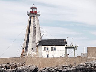
The Gannet Rock Lighthouse is a Canadian lighthouse located on a rocky islet 8 miles (13 km) south of Grand Manan in the Bay of Fundy. It was first lit in 1831 and was staffed until 1996. It was solarized in 2002 and remains operational in 2023. It was declared "surplus to requirements" by the Canadian Coast Guard in 2010 and is no longer being maintained.

References

  1. Rowlett, Russ. "Lighthouses of the United States: Central and Southern California". The Lighthouse Directory. University of North Carolina at Chapel Hill . Retrieved June 9, 2016.
  2. California Historic Light Station Information & Photography United States Coast Guard. Retrieved 9 June 2016
  3. "National Register Information System". National Register of Historic Places . National Park Service. July 9, 2010.
  4. "Historic Light Station Information and Photography: California". United States Coast Guard Historian's Office. Archived from the original on May 1, 2017.
  5. Anacapa Island Restoration Project. Channel Islands National Park. Final Environmental Impact Statement. Date not stated. Accessed July 21, 2018