
Yerba Buena Island sits in San Francisco Bay within the borders of the City and County of San Francisco. The Yerba Buena Tunnel runs through its center and connects the western and eastern spans of the San Francisco–Oakland Bay Bridge, linking the city with Oakland, California. Treasure Island is connected by a causeway to Yerba Buena Island. According to the United States Census Bureau, Yerba Buena Island and Treasure Island together have a land area of 0.901 square miles (2.33 km2) with a total population of 2,500 as of the 2010 census.

East Brother Island Lighthouse is a lighthouse located on East Brother Island in San Rafael Bay, near the tip of Point San Pablo in Richmond, California. It marks the entrance to San Pablo Bay from San Francisco Bay.

Alcatraz Island Lighthouse is a lighthouse—the first one built on the U.S. West Coast—located on Alcatraz Island in California's San Francisco Bay. It is located at the southern end of the island near the entrance to the prison. The first light house on the island was completed in 1854, and served the bay during its time as a Citadel and military prison. It was replaced by a taller concrete tower built in 1909 to the south of the original one which was demolished after it was damaged due to earthquake in 1906. The automation of the lighthouse with a modern beacon took place in 1963, the year Alcatraz closed as the Alcatraz Federal Penitentiary. It is the oldest light station on the island with a modern beacon and is part of the museum on the island. Although when viewed from afar it easily looks the tallest structure on Alcatraz, it is actually shorter than the Alcatraz Water Tower, but as it lies on higher ground it looks much taller.
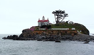
Battery Point Light is a lighthouse in Crescent City, California, United States. It is registered as a California Historical Landmark, and is listed on the National Register of Historic Places as "Crescent City Lighthouse".

The Point Reyes Lighthouse, also known as Point Reyes Light or the Point Reyes Light Station, is a lighthouse in the Gulf of the Farallones on Point Reyes in Point Reyes National Seashore, located in Marin County, California, United States.

Carquinez Strait Lighthouse is a lighthouse in California, United States. It was originally approximately 20 miles inland from the mouth of the San Francisco Bay near Vallejo, California.

Farallon Island Light is a lighthouse on Southeast Farallon Island, California. One of the highest lights in California, it was constructed in 1855 to warn ships approaching San Francisco from the west away from the rocky islands. In later years it was shorn of its lantern, but it remains in use.

Point Arena Light is a lighthouse in Mendocino County, California, United States, two miles (3 km) north of Point Arena, California. It is approximately 130 mi (210 km) north of San Francisco, in the Fort Point Group of lighthouses. The lighthouse features a small museum and gift shop. Guided tours of the light station as well as self-guided tours of the grounds are available daily.
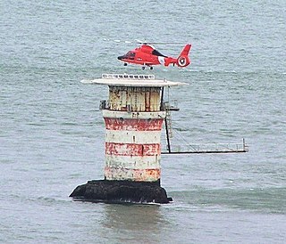
Mile Rocks Lighthouse is located on a rock about 1 mile (1.6 km) southwest of the Golden Gate Bridge, off of Lands End in San Francisco, California. It was completed in 1906, replacing a nearby bell buoy. In 1966, the light was automated, and the original 85 m (279 ft) tower of the lighthouse was demolished and replaced by a helipad. The lighthouse was at one time painted with alternating red and white rings, but as of 2017, the lighthouse is painted plain white.

The Point Montara Light is a lighthouse in Montara, California, United States, on the southern approach to the San Francisco Bay, California approximately 25 miles south of San Francisco.
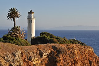
Point Vicente Lighthouse is a lighthouse in Rancho Palos Verdes, California, United States, north of Los Angeles Harbor. It is 67 feet (20 m) tall and stands on a cliff with a height of 130 feet (40 m). It is between Point Loma Lighthouse to the south and Point Conception Lighthouse to the north. The lighthouse was added to the National Register of Historic Places in 1980. The lighthouse is owned by the United States federal government and is managed by the United States Coast Guard. It is not usually open to the public, but the Coast Guard Auxiliary run tours once per month and it is used annually for the city's "Whale of a Day" festival.

Southampton Shoal is a former lighthouse site in California, United States. A platform sits at the southwest edge of Southampton Shoals, northeast of Angel Island in the San Francisco Bay. The platform is all that remains of the original structure and supports an automated bell which chimes every ten seconds and red light mounted on a pole, which flashes on for three seconds and is then dark for three seconds in each six second cycle.

Table Bluff Lighthouse is a lighthouse in California, United States, which was located on Table Bluff just south of Humboldt Bay. Built to guide vessels away from the notoriously dangerous and rough coastline and to let them know proximity of the nearby bay and entrance, the lighthouse was one of the first to be automated. The lighthouse tower portion is now located at the Woodley Island Marina within the City of Eureka.

Middle Bay Light, also known as Middle Bay Lighthouse and Mobile Bay Lighthouse, is an active hexagonal-shaped cottage style screw-pile lighthouse. The structure is located offshore from Mobile, Alabama, in the center of Mobile Bay.

Concord Point Light is a 36-foot (11 m) lighthouse in Havre de Grace, Maryland. It overlooks the point where Susquehanna River flows into the Chesapeake Bay, an area of increasing navigational traffic when it was constructed in 1827. It is the northernmost lighthouse and the second-oldest tower lighthouse still standing on the bay.

The Point San Luis Lighthouse, also known as the San Luis Obispo Light Station, is on the National Register of Historic Places. Located near Avila Beach on the Central Coast of California in San Luis Obispo County, it is the only Prairie Victorian model lighthouse left on the West Coast of the United States. It is being refurbished by the Point San Luis Lighthouse Keepers, a volunteer group.

The Cove Point Light is a lighthouse located on the west side of Chesapeake Bay in Calvert County, Maryland.
The Fog Point Light was a historic lighthouse located at Fog Point, the northwestern tip of Smith Island, Maryland in the Chesapeake Bay.
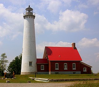
Tawas Point Light is located in the Tawas Point State Park off Tawas Bay in Lake Huron in Baldwin Township in Northern Michigan.
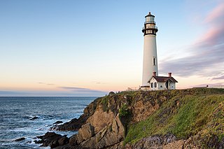
Pigeon Point Light Station or Pigeon Point Lighthouse is a lighthouse built in 1871 to guide ships on the Pacific coast of California. It is the tallest lighthouse on the West Coast of the United States. It is still an active Coast Guard aid to navigation. Pigeon Point Light Station is located on the coastal highway, 5 miles (8 km) south of Pescadero, California, between Santa Cruz and San Francisco. The 115-foot (35 m), white masonry tower, resembles the typical New England structure.


