National Register of Historic Places listings in Puerto Rico

Last updated

This is a list of properties and historic districts that are listed on the National Register of Historic Places (NRHP) in Puerto Rico, not to be confused with the Puerto Rico Register of Historic Sites and Zones. There are more than 375 listings in Puerto Rico, with one or more listing in each of Puerto Rico's 78 municipalities.

Contents

Puerto Rico's municipalities USA Puerto Rico labeled.svg
Puerto Rico's municipalities

For convenience, the list has been divided into six regions:

Current listings by municipality

Faro de los Morrillos de Cabo Rojo, in Cabo Rojo Cabo Rojo lighthouse.jpg
Faro de los Morrillos de Cabo Rojo, in Cabo Rojo
Convento de Porta Coeli, in San German Porta Coeli in San German (Puerto Rico).jpg
Convento de Porta Coeli, in San Germán
Cathedral Nuestra Senora de Guadalupe of Ponce, in Ponce Catedral Nuestra Senora de Guadalupe, Plaza Las Delicias, Ponce, Puerto Rico, mirando al noreste (Ponce002).jpg
Cathedral Nuestra Senora de Guadalupe of Ponce, in Ponce
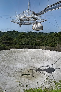
National Astronomy and Ionosphere Center (collapsed in late 2020), in Arecibo Arecibo radio telescope SJU 06 2019 6144.jpg
National Astronomy and Ionosphere Center (collapsed in late 2020), in Arecibo
Caguana Ceremonial Ball Courts Site, in Utuado Caguana Ceremonial Ball Courts Site - Utuado Puerto Rico.jpg
Caguana Ceremonial Ball Courts Site, in Utuado
Fuerte de Vieques, in Vieques Vieques pevnost Isabel II.jpg
Fuerte de Vieques, in Vieques
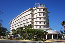
Streamline Moderne Normandie Hotel, in San Juan San Juan, PR 05.jpg
Streamline Moderne Normandie Hotel, in San Juan
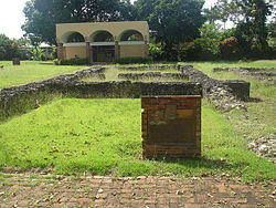
Historic Caparra, in Guaynabo Ponce de Leon house.JPG
Historic Caparra, in Guaynabo
MunicipalityRegional list# of Listings
1 Adjuntas Central 4
2 Aguada Western 1
3 Aguadilla Western 9
4 Aguas Buenas Central 1
5 Aibonito Central 4
6 Añasco Western 2
7 Arecibo Northern 15
8 Arroyo Eastern 1
9 Barceloneta Northern 1
10 Barranquitas Central 3
11 Bayamón Northern 7
12 Cabo Rojo Western 4
13 Caguas Central 7
14 Camuy Northern 3
15 Canóvanas Eastern 1
16 Carolina Eastern 3
17 Cataño Northern 2
18 Cayey Central 7
19 Ceiba Eastern 1
20 Ciales Central 1
21 Cidra Central 5
22 Coamo Central 8
23 Comerío Central 3
24 Corozal Central 1
25 Culebra Eastern 1
26 Dorado Northern 6
27 Fajardo Eastern 3
28 Florida Northern 1
29 Guánica Western 4
30 Guayama Southern 6
31 Guayanilla Southern 1
32 Guaynabo Northern 3
33 Gurabo Central 1
34 Hatillo Northern 1
35 Hormigueros Western 4
36 Humacao Eastern 7
37 Isabela Northern 1
38 Jayuya Central 1
39 Juana Díaz Southern 3
40 Juncos Central 1
41 Lajas Western 2
42 Lares Central 2
43 Las Marías Central 1
44 Las Piedras Eastern 1
45 Loíza Eastern 3
46 Luquillo Eastern 1
47 Manatí Northern 5
48 Maricao Central 3
49 Maunabo Eastern 2
50 Mayagüez Western 19
51 Moca Western 2
52 Morovis Central 1
53 Naguabo Eastern 4
54 Naranjito Central 2
55 Orocovis Central 1
56 Patillas Eastern 1
57 Peñuelas Southern 1
58 Ponce Southern 46
59 Quebradillas Northern 2
60 Rincón Western 2
61 Río Grande Eastern 5
62 Sabana Grande Western 6
63 Salinas Southern 1
64 San Germán Western 8
65 San Juan San Juan 68
66 San Lorenzo Central 2
67 San Sebastián Northern 1
68 Santa Isabel Southern 2
69 Toa Alta Northern 1
70 Toa Baja Northern 4
71 Trujillo Alto Central 1
72 Utuado Central 4
73 Vega Alta Northern 1
74 Vega Baja Northern 4
75 Vieques Eastern 31
76 Villalba Central 1
77 Yabucoa Eastern 1
78 Yauco Southern 9
(duplicates)(12) [lower-alpha 1]
Total377

See also

Notes

  1. Several historic resources in Puerto Rico span the boundaries between multiple municipalities and are included in each municipality's list:

Related Research Articles

<span class="mw-page-title-main">Caguas, Puerto Rico</span> City and municipality in Puerto Rico

Caguas is a city and municipality of Puerto Rico located in the Central Mountain Range of Puerto Rico, south of San Juan and Trujillo Alto, west of Gurabo and San Lorenzo, and east of Aguas Buenas, Cidra, and Cayey. Caguas was founded in 1775. The municipality had a population of 127,244 at the 2020 census.

<span class="mw-page-title-main">Cayey, Puerto Rico</span> Town and municipality in Puerto Rico

Cayey, officially Cayey de Muesas, is a mountain town and municipality in central Puerto Rico located on the Sierra de Cayey within the Central Mountain range, north of Salinas and Guayama; south of Cidra and Caguas; east of Aibonito and Salinas; and west of San Lorenzo. Cayey is spread over 21 barrios plus Cayey Pueblo. It is part of the San Juan-Caguas-Guaynabo Metropolitan Statistical Area.

<span class="mw-page-title-main">Coamo, Puerto Rico</span> Town and municipality in Puerto Rico

Coamo is a town and municipality founded in 1579 in the south-central region of Puerto Rico, located north of Santa Isabel; south of Orocovis and Barranquitas; east of Villalba and Juana Díaz; and west of Aibonito and Salinas. The municipality of Coamo is spread over 10 barrios and Coamo Pueblo – the town or downtown area and administrative center of the city. The Coamo municipality is also a Micropolitan Statistical Area and as such is part of the Ponce-Yauco-Coamo Combined Statistical Area.

<span class="mw-page-title-main">Añasco, Puerto Rico</span> Town and municipality in Puerto Rico

Añasco, named after one of its settlers, Don Luis de Añasco, is a town and municipality of Puerto Rico located on the west coast of the island bordering the Mona Passage to the west, north of Mayagüez, and Las Marias; south of Rincón, Aguada, and Moca and west of San Sebastián and Las Marias. It is part of the Aguadilla-Isabela-San Sebastián Metropolitan Statistical Area.

<span class="mw-page-title-main">Cidra, Puerto Rico</span> Town and municipality in Puerto Rico

Cidra is a town and municipality of Puerto Rico located in the central region of the island, north of Cayey; south of Comerío and Aguas Buenas; east of Aibonito and Barranquitas; and west of Caguas. Cidra is spread over 12 barrios and Cidra Pueblo. It is part of the San Juan-Caguas-Guaynabo Metropolitan Statistical Area.

<span class="mw-page-title-main">Puerto Rico Highway 52</span> Highway in Puerto Rico

Puerto Rico Highway 52 (PR-52), a major toll road in Puerto Rico, is also known as Autopista Luis A. Ferré. It was formerly called Expreso Las Américas. It runs from PR-1 in southwest Río Piedras and heads south until it intersects with highway PR-2 in Ponce. At its north end, the short PR-18 continues north from PR-52 towards San Juan. This short segment is known as Expreso Las Américas, the only segment of the route still unofficially bearing this name, since PR-18 is officially named Roberto Sánchez Vilella Expressway. The combined route of PR-18 and PR-52 runs concurrent with the unsigned Interstate Highway PRI-1. Toll stations are located in San Juan, Caguas, Salinas, Juana Díaz, and Ponce.

<span class="mw-page-title-main">Puerto Rico Highway 1</span> Highway in Puerto Rico

Puerto Rico Highway 1 (PR-1) is a highway in Puerto Rico that connects the city of Ponce to San Juan. Leaving Ponce, the road heads east and follows a somewhat parallel route along the southern coast of the island heading towards Salinas. At Salinas, the road turns north to cut through the Cordillera Central in its approach to San Juan. Before reaching San Juan, it climbs to make its way to the mountain town of Cayey and then it winds down into the city of Caguas on its final approach to San Juan.

<span class="mw-page-title-main">Puerto Rico Highway 15</span> Highway in Puerto Rico

Puerto Rico Highway 15 (PR-15), formerly Road No. 4, is a main highway connecting the municipalities of Guayama and Cayey in Puerto Rico. With a length of 25.80 km (16.03 mi), it extends from PR-3 in downtown Guayama to PR-14 in downtown Cayey.

The Ruta Panorámica, officially the Ruta Panorámica Luis Muñoz Marín, is a 167-mile (269 km) network of some 40 secondary roads which traverse the island of Puerto Rico from west to east along its Cordillera Central. Most of the route consists of three roads, PR-105, PR-143, and PR-182. The route starts in Mayagüez and ends in Maunabo. The first major segment of the route runs from Mayagüez to Maricao as Route 105, then from Adjuntas to Aibonito as Route 143, and then follows Route 182 toward Maunabo.

<span class="mw-page-title-main">National Register of Historic Places listings in northern Puerto Rico</span> Places in northern Puerto Rico listed on the US National Register of Historic Places

This portion of National Register of Historic Places listings in Puerto Rico is along the north coast, north plains, and north slopes of the Cordillera, from Isabela to Guaynabo.

<span class="mw-page-title-main">National Register of Historic Places listings in southern Puerto Rico</span>

This is a list of properties and districts in the southern municipalities of Puerto Rico that are listed on the National Register of Historic Places. It includes places along the southern coast of the island, and on the south slope of Puerto Rico's Cordillera Central.

<span class="mw-page-title-main">Arenas Bridge</span> Historic bridge in Cayey and Cidra municipalities, Puerto Rico

The Arenas Bridge is a truss bridge built in 1894 between the municipalities of Cayey and Cidra in Puerto Rico. Also known as Puente Rio La Plata, it was the longest bridge constructed in Puerto Rico during the Spanish colonial period. It crosses the Rio de la Plata, the longest river in Puerto Rico. According to the U.S. National Park Service, "[t]his is the most important metal bridge in Puerto Rico from the period." The bridge is still standing.

The Carretera Central is a historic north–south central highway in Puerto Rico, linking the cities of San Juan and Ponce by way of Río Piedras, Caguas, Cayey, Aibonito, Coamo, and Juana Díaz. It crosses the Cordillera Central. Plans for the road started in the first half of the 19th century, and the road was fully completed in 1898. At the time the United States took possession of Puerto Rico in 1898, the Americans called it "the finest road in the Western Hemisphere."

<span class="mw-page-title-main">National Register of Historic Places listings in central Puerto Rico</span> Places in central Puerto Rico listed on the US National Register of Historic Places

This portion of National Register of Historic Places listings in Puerto Rico is along the central mountain region, from Las Marías and Maricao in the central-west to Juncos in the central-east, including the slopes of the Cordillera.

<span class="mw-page-title-main">Porta Cordillera</span> Land-locked tourism region in the central mountainous region of Puerto Rico

Porta Cordillera, or simply Central Region, is a land-locked tourism region located in the central mountainous area of Puerto Rico. Porta Cordillera was officially launched in July 2012 by the Puerto Rico Tourism Company. It consists of 16 municipalities: Aguas Buenas, Cidra, Cayey, Comerío, Aibonito, Naranjito, Barranquitas, Corozal, Orocovis, Morovis, Ciales, Jayuya, Florida, Utuado, Adjuntas and Lares.

<span class="mw-page-title-main">La Liendre Bridge</span> Historic bridge in Cayey and Cidra municipalities, Puerto Rico

The La Liendre Bridge, spanning Beatriz Creek, a tributary to the Río de la Plata, between Cayey, Puerto Rico and Cidra, Puerto Rico. It was built in 1877 and was listed on the National Register of Historic Places in 1995, and on the Puerto Rico Register of Historic Sites and Zones in 2000.

<span class="mw-page-title-main">Cidra, Añasco, Puerto Rico</span> Barrio of Puerto Rico

Cidra is a barrio in the municipality of Añasco, Puerto Rico. Its population in 2010 was 326.

<span class="mw-page-title-main">Puerto Rico Highway 735</span> Highway in Puerto Rico

Puerto Rico Highway 735 (PR-735) is a rural road located between the municipalities of Cayey and Cidra, Puerto Rico, and it corresponds to an original segment of the historic Carretera Central. The Arenas and La Liendre old bridges are located on this route.

<span class="mw-page-title-main">Roads in Puerto Rico</span>

The Roads in Puerto Rico are the national, forest and municipal roadways that make up the approximately 14,400 kilometers (8,900 mi) roads through the terrain of Puerto Rico. The highways serve the more than 3 million residents, and 3-4 million tourists who visit each year.