List of NHLs
| [1] | Landmark name | Image | Date designated [2] | Location | County | Description |
|---|---|---|---|---|---|---|
| 1 | 1956 Grand Canyon TWA – United Airlines Aviation Accident Site |  | April 23, 2014 (#14000280) | Grand Canyon National Park 36°10′30″N111°49′59″W / 36.1750°N 111.833°W | Coconino | Crash area of first major (100+ deaths) commercial air disaster in the United States; led to creation of Federal Aviation Administration |
| 2 | Air Force Facility Missile Site 8 (Titan II ICBM Site 571-7) |  | April 19, 1994 (#92001234) | Green Valley 31°54′05″N110°59′54″W / 31.901339°N 110.998414°W | Pima | Last surviving Titan II missile launch facility; inactive |
| 3 | Apache Pass and Fort Bowie |  | December 19, 1960 (#72000194) | Bowie 32°08′46″N109°26′08″W / 32.146111°N 109.435556°W | Cochise | Commemorates the conflict between the Chiricahua Apaches and the United States military; preserves the ruins of Fort Bowie |
| 4 | Awatovi Ruins |  | July 19, 1964 (#66000187) | Keams Canyon 35°43′07″N110°16′37″W / 35.718611°N 110.276944°W | Navajo | Ruins of a 500-year-old pueblo visited by Coronado's men in 1540 |
| 5 | Casa Malpais Site |  | July 19, 1964 (#66000936) | Springerville 34°09′N109°18′W / 34.15°N 109.3°W | Apache | Ruin built around 1250; inhabited until about 1400 by Mogollon culture. Tours and museum |
| 6 | Mary Jane Colter buildings |  | May 28, 1987 (#87001436) | South Rim locations in Grand Canyon National Park 36°03′29″N112°08′13″W / 36.058056°N 112.136944°W | Coconino | Includes Desert View Watchtower, Hermits Rest, Hopi House, and The Lookout. |
| 7 | Desert Laboratory |  | December 21, 1965 (#66000190) | Tucson 32°13′31″N111°00′09″W / 32.225278°N 111.0025°W | Pima | Founded in 1903 to study plant adaptation to an arid desert environment with long term experiments, this laboratory contributed significantly to the formation of Ecology as a science. Part of the University of Arizona |
| 8 | Double Adobe Site |  | January 20, 1961 (#66000169) | Douglas 31°21′00″N109°32′00″W / 31.35°N 109.53333°W | Cochise | Archaeological site where development of the Cochise Culture occurred |
| 9 | El Tovar |  | May 28, 1987 (#74000334) | Grand Canyon Village 36°03′21″N112°08′13″W / 36.055704°N 112.136999°W | Coconino | Classic lodge at South Rim of Grand Canyon |
| 10 | Fort Apache and Theodore Roosevelt School |  | March 2, 2012 (#76000377) | Fort Apache 33°47′23″N109°59′21″W / 33.789812°N 109.98903°W | Navajo | Site of historic Fort Apache; later converted to a school for the purpose of assimilating the native population. It is now a tribal museum. |
| 11 | Fort Huachuca | 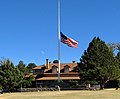 | May 11, 1976 (#74000443) | Sierra Vista 31°33′19″N110°20′59″W / 31.555278°N 110.349722°W | Cochise | Commemorates "Buffalo Soldiers" |
| 12 | Gatlin Site |  | July 19, 1964 (#66000183) | Gila Bend 32°58′51″N112°42′06″W / 32.980935°N 112.701612°W | Maricopa | Preserves a Hohokam platform mound, pit houses, ball courts, middens, and prehistoric canals |
| 13 | Grand Canyon Depot |  | May 28, 1987 (#74000337) | Grand Canyon Village 36°03′15″N112°08′11″W / 36.054295°N 112.136346°W | Coconino | Railway station constructed in 1909–10 for the Atchison, Topeka and Santa Fe Railroad |
| 14 | Grand Canyon Lodge |  | May 28, 1987 (#82001721) | North Rim, Grand Canyon National Park 36°11′57″N112°03′07″W / 36.199167°N 112.051944°W | Coconino | Lodge at Bright Angel Point, on North Rim of Grand Canyon. Destroyed by the Dragon Bravo Fire in 2025. |
| 15 | Grand Canyon Park Operations Building | 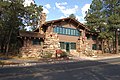 | May 28, 1987 (#87001412) | Grand Canyon Village 36°03′12″N112°08′13″W / 36.053226°N 112.136908°W | Coconino | National Park Service building; built in 1929; designed to blend with the natural surroundings |
| 16 | Grand Canyon Power House | 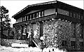 | May 28, 1987 (#87001411) | Grand Canyon Village 36°03′14″N112°08′24″W / 36.053873°N 112.139970°W | Coconino | Rustic building designed to conceal the purpose of the building, which was to provide power to the railroad. |
| 17 | Grand Canyon Village |  | February 18, 1987 (#75000343) | Grand Canyon Village 36°03′20″N112°08′18″W / 36.055556°N 112.138333°W | Coconino | Planned town significant for its urban planning and ecological sensitivity |
| 18 | Hoover Dam |  | August 20, 1985 (#81000382) | Lake Mead National Recreation Area 36°00′56″N114°44′16″W / 36.015556°N 114.737778°W | Mohave, AZ and Clark, NV | Historic dam, power plant and water-storage facility |
| 19 | Hubbell Trading Post |  | December 12, 1960 (#66000167) | Ganado 35°43′32″N109°35′36″W / 35.725556°N 109.59333°W | Apache | Meeting ground of two cultures, the Navajo and the settlers |
| 20 | Jerome Historic District |  | November 13, 1966 (#66000196) | Jerome 34°45′13″N112°06′41″W / 34.753611°N 112.111389°W | Yavapai | Copper mining town |
| 21 | Kinishba Ruins |  | July 19, 1964 (#66000180) | Whiteriver 33°48′53″N110°03′16″W / 33.814722°N 110.054444°W | Gila | Large pueblo ruin; accessible via Fort Apache Historical Park. |
| 22 | Klagetoh (Leegito) Chapter House | January 13, 2021 (#100006279) | Klagetoh 35°29′58″N109°31′48″W / 35.4994°N 109.5299°W | Apache | ||
| 23 | Lehner Mammoth-Kill Site |  | May 28, 1967 (#67000002) | Hereford 31°26′00″N110°06′00″W / 31.433333°N 110.1°W | Cochise | Clovis culture mammoth butchering site |
| 24 | Los Santos Ángeles de Guevavi |  | June 21, 1990 (#71000119) | Nogales 31°24′36″N110°54′10″W / 31.409908°N 110.902689°W | Santa Cruz | Ruins of Spanish mission church; founded 1691 |
| 25 | Lowell Observatory |  | December 21, 1965 (#66000172) | Flagstaff 35°12′10″N111°39′52″W / 35.202778°N 111.664444°W | Coconino | Observatory where Pluto was discovered |
| 26 | C. Hart Merriam Base Camp Site |  | December 21, 1965 (#66000173) | Flagstaff 35°22′29″N111°43′34″W / 35.374824°N 111.725990°W | Coconino | Work site of C. Hart Merriam, path-breaking eco-biologist |
| 27 | Murray Springs Clovis Site | 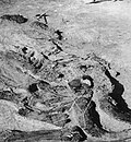 | October 16, 2012 (#12001019) | Sierra Vista 31°34′14″N110°08′27″W / 31.570638°N 110.140872°W | Cochise | Clovis culture site associated with bison and mammoth kills; site open to public. |
| 28 | Navajo Nation Council Chamber |  | August 18, 2004 (#04001155) | Window Rock 35°40′58″N109°02′54″W / 35.682778°N 109.048333°W | Apache | Center of government for Navajo Nation. |
| 29 | Old Oraibi |  | July 19, 1964 (#66000188) | Oraibi 35°52′35″N110°38′25″W / 35.876389°N 110.640278°W | Navajo | Historic Hopi village |
| 30 | Painted Desert Community Complex Historic District |  | December 23, 2016 (#100000838) | One Park Rd. 35°04′06″N109°46′50″W / 35.068333°N 109.780556°W | Apache | |
| 31 | Painted Desert Inn | 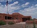 | May 28, 1987 (#87001421) | Petrified Forest National Park 35°05′01″N109°47′20″W / 35.083737°N 109.788845°W | Apache | Lodge in the Petrified Forest National Park |
| 32 | Phelps Dodge General Office Building |  | May 4, 1983 (#71000109) | Bisbee 31°26′25″N109°54′41″W / 31.440186°N 109.911261°W | Cochise | Phelps Dodge mining company headquarters from 1896 to 1961 |
| 33 | Point of Pines Sites |  | July 19, 1964 (#66000182) | San Carlos Apache Indian Reservation 33°21′13″N109°44′40″W / 33.3535°N 109.7445°W | Graham | Set of archaeological sites associated with Anasazi, Mogollon and Hohokam cultures; location is site of archaeological field camp |
| 34 | Poston Elementary School, Unit 1, Colorado River Relocation Center |  | October 16, 2012 (#12001010) | Parker 33°59′31″N114°24′24″W / 33.991943°N 114.406625°W | La Paz | Located at the former Poston War Relocation Center, this is the only surviving elementary school building from any World War II-era Japanese internment camp. |
| 35 | Pueblo Grande Ruin and Irrigation Sites |  | July 19, 1964 (#66000185) | Phoenix 33°26′47″N111°59′03″W / 33.446389°N 111.984167°W | Maricopa | Pueblo Grande Ruin and adjacent Hohokam-Pima Irrigation Sites |
| 36 | Sage Memorial Hospital School of Nursing | January 16, 2009 (#09000082) | Ganado 35°42′40″N109°32′36″W / 35.711073°N 109.543446°W | Apache | ||
| 37 | San Bernardino Ranch |  | July 19, 1964 (#66000170) | Douglas 31°20′11″N109°16′47″W / 31.336389°N 109.279722°W | Cochise | Historic cattle ranch |
| 38 | San Cayetano de Calabazas |  | December 14, 1990 (#71000118) | Nogales 31°27′09″N110°57′34″W / 31.4525°N 110.959444°W | Santa Cruz | Spanish mission, also known as Calabasas; part of Tumacácori National Historic Park. |
| 39 | San Xavier del Bac Mission |  | October 9, 1960 (#66000191) | Tucson 32°06′25″N111°00′29″W / 32.107°N 111.008°W | Pima | Spanish mission founded in 1699 |
| 40 | Sierra Bonita Ranch |  | July 19, 1964 (#66000181) | Bonita 32°35′00″N109°58′00″W / 32.583333°N 109.966667°W | Cochise and Graham | First permanent American cattle ranch in Arizona |
| 41 | Snaketown |  | April 29, 1964 (#07001462) | Hohokam Pima National Monument 33°10′59″N111°55′12″W / 33.183056°N 111.92°W | Pinal | Archaeological remains of the Hohokam culture |
| 42 | Taliesin West | 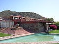 | May 20, 1982 (#74000457) | Scottsdale 33°36′11″N111°50′38″W / 33.603111°N 111.843781°W | Maricopa | Winter home of architect Frank Lloyd Wright |
| 43 | Tombstone Historic District |  | July 4, 1961 (#66000171) | Tombstone 31°42′45″N110°03′59″W / 31.7125°N 110.066389°W | Cochise | Classic Western mining boomtown; location of the OK Corral |
| 44 | Tumacacori Museum |  | May 28, 1987 (#87001437) | Tumacacori 31°33′58″N111°03′01″W / 31.566065°N 111.050402°W | Santa Cruz | Museum to Spanish missions that itself is an architectural landmark |
| 45 | Ventana Cave |  | January 20, 1964 (#66000189) | Santa Rosa 32°21′00″N112°14′00″W / 32.35°N 112.233333°W | Pima | Archaeological site; has evidence of Native American occupation of the area for the last 4,000 years |
| 46 | Winona Site | July 19, 1964 (#66000177) | Winona 35°12′00″N111°24′00″W / 35.200°N 111.400°W | Coconino | Archaeological site; evidence of cultural change following eruption of Sunset Crater | |
| 47 | Yuma Crossing and Associated Sites |  | November 13, 1966 (#66000197) | Yuma, AZ and Winterhaven, CA 32°43′43″N114°36′52″W / 32.728611°N 114.614444°W | Yuma County, AZ and Imperial County, CA | Archaeological and historical sites including Yuma Quartermaster Depot and Arizona Territorial Prison |
