Kinishba Ruins

Last updated

Kinishba Ruins
Kinishba.jpg
Kinishba Ruins
USA Arizona location map.svg
Red pog.svg
Usa edcp location map.svg
Red pog.svg
Location Gila County, Arizona, USA
Nearest city Canyon Day, Arizona
Coordinates 33°48′53″N110°03′16″W / 33.81472°N 110.05444°W / 33.81472; -110.05444
Architect Vernacular
Architectural style Ancestral Pueblo
NRHP reference No. 66000180
Significant dates
Added to NRHPOctober 15, 1966 [1]
Designated NHLDJuly 19, 1964 [2]
Kinishba ruins panorama Kinishba-ruins-pano.jpg
Kinishba ruins panorama

Kinishba Ruins is a 600-room Mogollon great house archaeological site in eastern Arizona and is administered by the White Mountain Apache Tribe. It is located on the present-day Fort Apache Indian Reservation, in the Apache community of Canyon Day. As it demonstrates a combination of both Mogollon and Ancestral Puebloan cultural traits, archaeologists consider it part of the historical lineage of both the Hopi and Zuni cultures. [3] It is designated as a National Historic Landmark.

Contents

Kinishba's elevation is about 5,000 feet (1,500 m). It lies above a pine-fringed alluvial valley, west of Fort Apache, in the White Mountain Apache Tribal community of Canyon Day. Long known to the Apache people of the region and alleged to have been visited by Conquistadors, the site was first written about in English in 1892, when pioneering archaeologist Adolph Bandelier described the ruins. In 1964, the NPS designated the site as a National Historic Landmark. It had long been abandoned and fallen into disrepair. The ruins received limited cleanup and restoration in 2005–2007. [3]

Scholars believe that Kinishba may have been the pueblo Chiciticale referred to in narratives of the 1540–41 Spanish expedition led by Francisco Vásquez de Coronado.

Etymology

From 1931 to 1940, the archaeologist Dr. Byron Cummings, Director of the Arizona State Museum (and head of the Department of Archeology at the University of Arizona), led a team of archaeology students and local Apache field assistants over several seasons to excavate and restore Kinishba. He named the site, ki datbaa, derived from the Apache words meaning "brown house".

Description

Kinishba

A large Kinishba bowl held by Prof. Byron Cummings, who excavated the ruins in the 1930s. Photo shows other pottery collected by Cummings at Kinishba or nearby. Circa 1940s photo by Arizona State Museum. Byron Cummings at Arizona State Museum non-free.jpg
A large Kinishba bowl held by Prof. Byron Cummings, who excavated the ruins in the 1930s. Photo shows other pottery collected by Cummings at Kinishba or nearby. Circa 1940s photo by Arizona State Museum.

Kinishba is about 5,000 feet (1,500 m) above sea level, south of the Mogollon Rim and north of the Salt River. It is at the eastern foot of Tsé Sizin ("Rock Standing Up" or Sawtooth Mountain), on White Mountain Apache trust lands associated with the Fort Apache Indian Reservation. The ruins are located in a valley that slopes to the right bank of the White River. The site is easily accessible in comparison to the other 20 or so large (150 or more rooms) Ancestral Pueblo village ruins in the Fort Apache area. Estimates suggest the ruins were built and occupied from the 12th to 14th centuries as part of the ancient population boom within the Mogollon Rim region and beyond. Centralized in the lush mountains of the Mt. Baldy watershed, the area has been linked to both Mogollon and Anasazi cultures. They were considered part of the western Pueblo complex. [4]

The Kinishba pueblo is composed of nine major building mounds, the remains of masonry room blocks, some of which were originally three stories tall. There were two large apartment blocks, and several smaller buildings, with two communal courtyards. At its peak, Kinishba may have housed up to 1,000 to 1,500 people. The masonry walls are unique for their double-walled construction: one side is faced and the other made of rubble. [4] The rooms averaged 14 by 12 feet (4.3 by 3.7 m), with a firepit in the center. Scholars believe that most families occupied two rooms, one for living quarters and one for storage. [4]

In the smaller courtyard was a kiva , a room built underground for religious ceremonies. The larger courtyard revealed evidence of three ceremonial stages. It is 63 by 51 feet (19 by 16 m). In the first stage, of the late 12th century or early 13th century, five underground rooms, each the size of the kiva, were built; they had earthen rather than masonry walls. About the middle of the 13th century, these rooms were filled in. Juniper posts were set into the ground to support beams and a roof, making a large, above-ground room of the courtyard. Later the roof burned, and researchers found no evidence that it was replaced. Ceremonies were moved to other rooms of the pueblo. [4]

Construction and habitation in the Fort Apache region

Mogollon range of influence at the time of Kinishba habitation Hohokam, Ancestral Pueblo, and Mogollon cultures circa 1350 CE.png
Mogollon range of influence at the time of Kinishba habitation

The largest 13th- and 14th-century ruins along the Mogollon Rim all share architectural elements, ceramic assemblages, and similar locational characteristics. They are proximate to expanses of land suitable for dry maize farming, and they have ready access to domestic water, tabular sandstone or limestone, and ponderosa pine. [3]

All of these large villages were built up from apartment-style room blocks, laid out to define communal courtyards or plazas.

The resident people cultivated corn, beans and gourds nearby, which were raised together to conserve moisture. They may have raised cotton as well, and gathered fruits, berries, nuts and other foods locally. The White Mountains region served as plentiful resource that allowed for hunting and gathering of food. The women processed the meat for food, and the skin, sinew and bones for clothing, tools, and other needs. [4]

Kinishba and her sister villages were abandoned by the Mogollon people in the late 14th or early 15th century for unknown reasons. It may have been related to a water source drying up. [3] [4] The area saw little human interaction until the arrival of the nomadic culture of the Apache from the western Great Plains. The ruins were not used by the Apache. [4]

Archeological excavation

Over the years, the site was pulled apart by pot hunters and soldiers from Fort Apache seeking souvenirs. In 1892 Adolph Bandelier, a pioneering archaeologist, was the first European to write about the site, and other archeologists visited it.

From 1931 into the 1940s, Byron Cummings of the University of Arizona led a team of students and a varying workforce of 10 to 27 White Mountain Apache to excavate and restore the site. Cummings named the site, derived from the Apache words ki datbaa, meaning "brown house".

He created a university field school at the camp of the site, which had seasons from 1931 to 1939. [3] He used a variety of funding means, including his broad network of supporters and the Civilian Conservation Corps and Bureau of Indian Affairs (which administered the Fort Apache Agency), to pay for workers and materials. Chester Holden, David Kane, and Turner Thompson were Apache men who spent at least five seasons at the site and became strongly attached to the preservation project. [3]

In addition, the teams built a small museum and tourist site in 1939 to hold artifacts and interpret the site. Built during the Great Depression, the museum was intended also as a place for the Apache to sell their contemporary arts and crafts, and to provide continuing employment for tribal members. Cummings was a scholar-entrepreneur, who "combined archaeological research and training; intertribal and interagency collaboration; historic preservation; and museum, community, and tourism enterprise development" in the first project of its kind in Arizona." [3] With his teams, Cummings "excavated at least 220 rooms", and "rebuilt about 140". He enhanced what today is called a heritage tourism destination. [3]

Cummings believed that the site was so important that it should be designated by the Department of the Interior as a National Monument and added to properties managed by the National Park Service. The agency gave preference to more accessible sites, given the needs of the Great Depression quickly followed by World War II. Cummings did not succeed in having the NPS take over the site. [3]

In 1956 the Department of the Interior published a pamphlet on the site, referring to the "Kinishba Ruins and Museum". [4] The site was declared a National Historic Landmark in 1964 by the Department of the Interior and added to the National Register of Historic Places.

Since then, the ruins have not been maintained and have deteriorated, as did the museum. A partial restoration was done in 2005–2007 to stabilize much of the site. The complex is administered by the White Mountain Apache Tribe and the Fort Apache Heritage Foundation as a "satellite" element of the Fort Apache Historic Park. [3] The White Mountain Apache require visitors to obtain a permit to visit the Kinishba Ruins site.

The White Mountain Apache have built their own museum at the Fort Apache Historic Park, based on their traditional style of a gowa, or home. It is called Nohwike' Bágowa (House of Our Footprints), or the White Mountain Apache Culture Center and Museum. [5] The park includes a 288-acre (117 ha) National Historic District, with 27 buildings dating from the US Army's use of the fort during the Apache Wars. The reservation has standing structures ranging in age from ancient to contemporary times. The tribe has provided explanations of the history of the Mogollon Rim Pueblo, as well as the historic and contemporary White Mountain Apache.

See also

Footnotes

  1. "National Register Information System". National Register of Historic Places . National Park Service. January 23, 2007.
  2. "Kinishba Ruins". National Historic Landmark summary listing. National Park Service. Archived from the original on November 29, 2007. Retrieved December 3, 2007.
  3. 1 2 3 4 5 6 7 8 9 10 Welch, John R. " 'A Monument to Native Civilization': Byron Cummings' Still-Unfolding Vision for Kinishba Ruins", Journal of the Southwest 49 (1): 1–94, 22 March 2007, at Highbeam, accessed 31 July 2011
  4. 1 2 3 4 5 6 7 8 James B. Shaeffer, "Kinishba, A Classic Site of the Western Pueblos", Washington, DC: US Bureau of Indian Affairs, 1956, accessed 1 August 2011
  5. "Fort Apache Historic Park and Kinishba Ruins", Nohwike' Bágowa (House of Our Footprints), White Mountain Apache Culture Center & Museum, accessed 1 August 2011

Related Research Articles

<span class="mw-page-title-main">Hohokam</span> Prehistoric culture in the North American Southwest

Hohokam was a culture in the North American Southwest in what is now part of Arizona, United States, and Sonora, Mexico. It existed between 300 and 1500 CE, with cultural precursors possibly as early as 300 BCE. Archaeologists disagree about whether communities that practiced the culture were related or politically united. According to local oral tradition, Hohokam societies may be the ancestors of the historic Akimel and Tohono Oʼodham in Southern Arizona.

<span class="mw-page-title-main">Mogollon culture</span> Prehistoric culture of the southwest United States and northern Mexico

Mogollon culture is an archaeological culture of Native American peoples from Southern New Mexico and Arizona, Northern Sonora and Chihuahua, and Western Texas. The northern part of this region is Oasisamerica, while the southern span of the Mogollon culture is known as Aridoamerica.

<span class="mw-page-title-main">Navajo National Monument</span> National monument in Arizona, United States

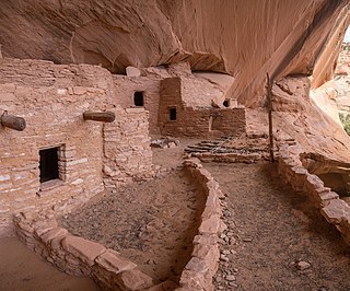
Navajo National Monument is a National Monument located within the northwest portion of the Navajo Nation territory in northern Arizona, which was established to preserve three well-preserved cliff dwellings of the Ancestral Puebloan people: Keet Seel, Betatakin, and Inscription House. The monument is high on the Shonto plateau, overlooking the Tsegi Canyon system, west of Kayenta, Arizona. It features a visitor center with a museum, three short self-guided trails, two small campgrounds, and a picnic area.

<span class="mw-page-title-main">El Cuartelejo</span> Region in Colorado and Kansas, United States

El Cuartelejo, or El Quartelejo, is a region in eastern Colorado and western Kansas where Plains Apache cohabited with Puebloans. Subject to religious persecution, Puebloans fled the Spanish Nuevo México territory and cohabitated with the Cuartelejo villagers in the 1600s.

<span class="mw-page-title-main">Sinagua</span> Pre-Columbian culture in Arizona, US

The Sinagua were a pre-Columbian culture that occupied a large area in central Arizona from the Little Colorado River, near Flagstaff, to the Verde River, near Sedona, including the Verde Valley, area around San Francisco Mountain, and significant portions of the Mogollon Rim country, between approximately 500 and 1425 CE.

<span class="mw-page-title-main">Fort Apache Indian Reservation</span> Native American nation in Arizona

The Fort Apache Indian Reservation is an Indian reservation on the border of New Mexico and Arizona, United States, encompassing parts of Navajo, Gila, and Apache counties. It is home to the federally recognized White Mountain Apache Tribe of the Fort Apache Reservation, a Western Apache tribe. It has a land area of 1.6 million acres and a population of 12,429 people as of the 2000 census. The largest community is in Whiteriver.

<span class="mw-page-title-main">Hawikuh Ruins</span> United States historic place

Hawikuh, was one of the largest of the Zuni pueblos at the time of the Spanish entrada. It was founded around 1400 AD. It was the first pueblo to be visited and conquered by Spanish explorers. The Spanish chroniclers referred to it as Cevola, Tzibola, or Cibola.

<span class="mw-page-title-main">Oasisamerica</span> Pre-Columbian cultural region of North America

Oasisamerica is a term that was coined by Paul Kirchhoff and published in a 1954 article, and is used by some scholars, primarily Mexican anthropologists, for the broad cultural area defining pre-Columbian southwestern North America. It extends from modern-day Utah down to southern Chihuahua, and from the coast on the Gulf of California eastward to the Río Bravo river valley. Its name comes from its position in relationship with the similar regions of Mesoamerica and mostly nomadic Aridoamerica. The term Greater Southwest is often used to describe this region by American anthropologists.

<span class="mw-page-title-main">Casa Malpaís</span> Historic place in Apache County, Arizona

Casa Malpaís is an archaeological site of the Ancestral Puebloans located near the town of Springerville, Arizona. The site is a nationally recognized archaeological site and was declared a National Historic Landmark in 1964.

<span class="mw-page-title-main">Emil Haury</span> American archaeologist (1904–1992)

Emil Walter "Doc" Haury was an American archaeologist who specialized in the archaeology of the American Southwest. He is most famous for his work at Snaketown, a Hohokam site in Arizona.

<span class="mw-page-title-main">Point of Pines Sites</span> Archaeological sites in Arizona, United States

The Point of Pines Sites are a set of archaeological sites on the San Carlos Apache Indian Reservation in the U.S. state of Arizona. Located around the settlement of Point of Pines, they are significant for associations with Ancestral Pueblo, Mogollon and Hohokam cultures. The sites were chosen as a field school location by Dr. Emil Haury because of the unusual presence of all three major prehistoric cultures of Arizona. The field school ran from 1946 to 1960, collecting large amounts of evidence from numerous sites. The site were collectively declared a National Historic Landmark in 1964.

<span class="mw-page-title-main">Pueblo Grande Ruin and Irrigation Sites</span> Archaeological park in Arizona

Pueblo Grande Ruin and Irrigation Sites are pre-Columbian archaeological sites and ruins, located in Phoenix, Arizona. They include a prehistoric platform mound and irrigation canals. The City of Phoenix manages these resources as the S’edav Va’aki Museum.

<span class="mw-page-title-main">Tuzigoot National Monument</span> Historic site in Yavapai County, Arizona, US

Tuzigoot National Monument preserves a 2- to 3-story pueblo ruin on the summit of a limestone and sandstone ridge just east of Clarkdale, Arizona, 120 feet (37 m) above the Verde River floodplain. The Tuzigoot Site is an elongated complex of stone masonry rooms that were built along the spine of a natural outcrop in the Verde Valley. The central rooms stand higher than the others and they appear to have served public functions. The pueblo has 110 rooms. The National Park Service currently administers 58 acres, within an authorized boundary of 834 acres.

Bailey Ruin is an archaeological site located in Navajo County, Arizona, United States. The site, also known as "Stott Ranch Ruin" and "Pope Ranch Site," was added to the National Register of Historic Places on March 17, 2006 for its historical and archaeological significance.

<span class="mw-page-title-main">Ancestral Puebloans</span> Ancient Native American culture in Four Corners region of the US

The Ancestral Puebloans, also known as the Anasazi, were an ancient Native American culture that spanned the present-day Four Corners region of the United States, comprising southeastern Utah, northeastern Arizona, northwestern New Mexico, and southwestern Colorado. They are believed to have developed, at least in part, from the Oshara tradition, which developed from the Picosa culture. The people and their archaeological culture are often referred to as Anasazi, meaning "ancient enemies", as they were called by Navajo. Contemporary Puebloans object to the use of this term, with some viewing it as derogatory.

<span class="mw-page-title-main">Sherwood Ranch Pueblo</span> United States historic place

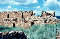
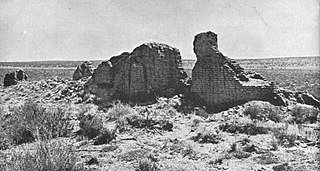
Sherwood Ranch Pueblo is an historic pueblo located overlooking the Little Colorado River, near Springerville, Arizona. It has two areas of habitation, consisting of over 800 rooms and was inhabited from approximately 1000-1450 A.D.

<span class="mw-page-title-main">Byron Cummings</span> American college administrator (1860–1954)

Byron G. Cummings was an American archaeologist and university president. He is known as the dean of Southwestern archaeology. Cummings was the founding head of University of Arizona's Department of Archaeology (1915–1937), the school's ninth president (1927–1928), the Arizona State Museum's first director (1915–1938), and the founder of the Arizona Archaeological and Historical Society, which was established in 1916.

<span class="mw-page-title-main">Indigenous peoples of the North American Southwest</span> Regional culture of native peoples in southwestern North America

The Indigenous peoples of the North American Southwest are those in the current states of Colorado, Arizona, New Mexico, Utah, and Nevada in the western United States, and the states of Sonora and Chihuahua in northern Mexico. An often quoted statement from Erik Reed (1964) defined the Greater Southwest culture area as extending north to south from Durango, Mexico to Durango, Colorado and east to west from Las Vegas, Nevada to Las Vegas, New Mexico. Other names sometimes used to define the region include "American Southwest", "Northern Mexico", "Chichimeca", and "Oasisamerica/Aridoamerica". This region has long been occupied by hunter-gatherers and agricultural people.

<span class="mw-page-title-main">Grasshopper Pueblo</span> Formerly populated place in North America

Grasshopper Pueblo, sometimes called Grasshopper Ruin, was a populated place from 1275 to 1400 CE at what is now Fort Apache Indian Reservation, about 10 mi (16 km) west of Cibecue in east-central Arizona in the United States. The settlement was a multicultural community that housed people from Puebloan, Mogollon and possibly Salado backgrounds, et al. Initial excavations of the "extremely large" masonry pueblo found 500 rooms, two smaller pueblos of 20 to 30 rooms, multiple kivas, hearths, courtyards, refuse dumps, multiple cemeteries, grave goods, and animal burials.

References

Further reading