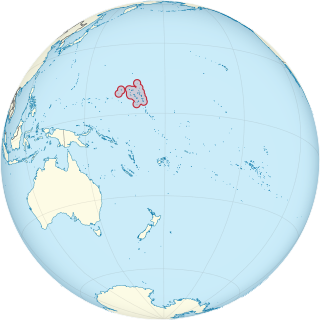
This is a list of the buildings, sites, districts, and objects listed on the National Register of Historic Places in the Marshall Islands. There are currently 4 listed sites located in only three of the 24 atolls that make up the Marshall Islands.
This National Park Service list is complete through NPS recent listings posted April 14, 2023.
This is a list of properties and historic districts in Tennessee that are listed on the National Register of Historic Places. There are over 2,000 in total. Of these, 29 are National Historic Landmarks. Each of Tennessee's 95 counties has at least one listing.

This is a list of the buildings, sites, districts, and objects listed on the National Register of Historic Places in the Northern Mariana Islands. There currently 37 listed sites spread across the four municipalities of the Northern Mariana Islands. There are no sites listed on any of the islands that make up the Northern Islands Municipality.

This is a list of properties and historic districts in Iowa that are listed on the National Register of Historic Places. There are listings in all of Iowa's 99 counties, adding up to over 2,300 total.

This is a list of properties and historic districts in Montana that are listed on the National Register of Historic Places. The state's more than 1,100 listings are distributed across all of its 56 counties.

This is a list of the buildings, sites, districts, and objects listed on the National Register of Historic Places in American Samoa. There are currently 31 listed sites spread across the three districts of American Samoa. There are no sites listed on the unorganized atoll of Swains Island.

There are 461 properties and historic districts listed on the National Register of Historic Places in North Dakota. There are listings in 52 of North Dakota's 53 counties.

This is a list of the buildings, sites, districts, and objects listed on the National Register of Historic Places in the Republic of Palau. There are currently six listed sites located in only four of the sixteen states of Palau.
This National Park Service list is complete through NPS recent listings posted April 14, 2023.

This is a list of the buildings, sites, districts, and objects listed on the National Register of Historic Places in the United States Virgin Islands. There are currently 88 listed sites spread across 16 of the 20 subdistricts within three islands/districts of the United States Virgin Islands. Four sites are additionally designated National Historic Landmarks and two others as National Historic Sites.

This is a list of properties and historic districts in Missouri on the National Register of Historic Places. There are NRHP listings in all of Missouri's 114 counties and the one independent city of St. Louis.
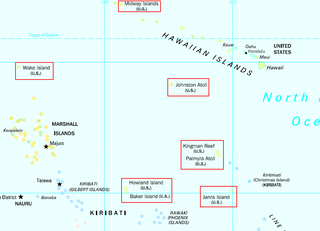
This is a list of the buildings, sites, districts, and objects listed on the National Register of Historic Places across the United States Minor Outlying Islands. There are currently two listed sites located on two of the twelve islands or atolls that make up the Minor Outlying Islands.
This National Park Service list is complete through NPS recent listings posted April 14, 2023.


