
The Federated States of Micronesia, or simply Micronesia, is an island country in Oceania. It consists of four states – from west to east, Yap, Chuuk, Pohnpei and Kosrae – that are spread across the western Pacific. Together, the states comprise around 607 islands that cover a longitudinal distance of almost 2,700 km (1,678 mi) just north of the equator. They lie northeast of Indonesia and Papua New Guinea, south of Guam and the Marianas, west of Nauru and the Marshall Islands, east of Palau and the Philippines, about 2,900 km (1,802 mi) north of eastern Australia, 3,400 km (2,133 mi) southeast of Japan, and some 4,000 km (2,485 mi) southwest of the main islands of the Hawaiian Islands.

This is a list of the buildings, sites, districts, and objects listed on the National Register of Historic Places in the Federated States of Micronesia. There are currently 26 listed sites located in all 4 states of the Federated States of Micronesia.

Sackets Harbor Battlefield State Historic Site is a historically important location in Jefferson County, New York, United States. The historic site is south of the Village of Sackets Harbor, bordering Lake Ontario in the Town of Hounsfield. Two battles were fought near this location during the War of 1812. Some 3,000 men worked at the shipyard building warships, and the village was fortified and garrisoned with thousands of troops.
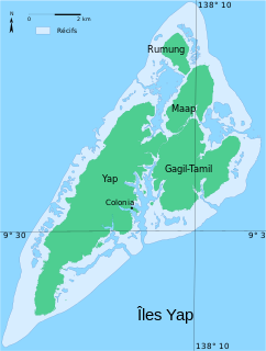
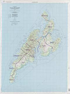
Yap traditionally refers to an island group located in the Caroline Islands of the western Pacific Ocean, a part of Yap State. The name "Yap" in recent years has come to also refer to the state within the Federated States of Micronesia, inclusive of the Yap Main Islands and its various outer islands, the Yap Neighboring Islands. For specifying the island group, the name Yap Main Islands is most exact.

Rota Latte Stone Quarry, also known as the As Nieves quarry, is located near the Chamorro village of Sinapalo, on the island of Rota in the Marianas Archipelago. The prehistoric megaliths found there are believed to have been used as foundation pillars for houses, with some of them weighing up to 35 tons. Their exact age, origin, methods of quarrying and means of transportation have not been determined.

The House of Taga is an archeological site located near San Jose Village, on the island of Tinian, United States Commonwealth of the Northern Mariana Islands, in the Marianas Archipelago. The site is the location of a series of prehistoric latte stone pillars which were quarried about 4,000 feet (1,200 m) south of the site, only one of which is left standing erect due to past earthquakes. The name is derived from a mythological chief named Taga, who is said to have erected the pillars as a foundation for his own house.
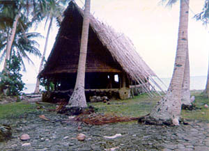
The Rull Men's Meetinghouse is a historic meeting house in Rull, a village on the island of Yap in the Federated States of Micronesia. It is a large rectangular structure, set on a raised stone platform. The flooring consists of treated betelnut palm trunks, and has a steeply pitched roof made of bamboo supports with various types of tropical leaves tied in place using coconut fiber. The faluw, although not the first built on this platform, has historically occupied a central place in the civic life of the community, serving as a place where the men of the village could meet in seclusion, and as a place for social rites.
The Japanese Lighthouse, or Poluwat Lighthouse, is an abandoned lighthouse situated on Alet Island in Poluwat, Chuuk in the Federated States of Micronesia. It was completed in 1940 by the Japanese and was in use until being attacked by U.S. forces in World War II. It was listed on the National Register of Historic Places in 1983. The lighthouse is a good example of pre-World War II "marine architecture" built by the Japanese.
Safonfok is a prehistoric archaeological site near Walung, on the island of Kosrae in the Federated States of Micronesia. At the time of its discovery in 1999, it was one of the largest prehistoric industrial complex found in the islands of the Pacific. The site, whose extent has not been fully determined, was excavated in 1999-2000, revealing a major complex where an estimated hundreds of workers manufactured coral fish hooks and other tools. Unique among the finds are a basalt knife and a diamond-shaped bead.

Tarang, also known as O'Keefe's Island is a small island in the main harbor of Yap Island in the Federated States of Micronesia. It is located roughly in the center of the harbor east of Colonia, the Yapese capital, between Pekel and Bi Islands. It is a low island with a maximum height of about 22 feet (6.7 m), and is overgrown with tropical vegetation. The island has local historical importance as the home of Captain David O'Keefe, an enterprising American who arrived on Yap in the 1870s, and was responsible for not only significant economic growth, but also for the depreciation of the distinctive Yapese currency, the large rai stones which became devalued after O'Keefe introduced iron tools that made manufacture of the stones easier. O'Keefe settled on Tarang, where he had a boat landing, coal warehouse, and house. Of these structures, only the boat landing has survived; only foundations survive of the others.
The Spanish Fort in Colonia, the capital of Yap State in the Federated States of Micronesia, is a historic seat of power on the island of Yap. Only foundational remnants of the 19th-century Spanish fortification survive, on a property now occupied by the local government. The site was also where German and Japanese administrators had their headquarters during their respective periods of administration in the decades of the 20th century before World War II. The foundation was built of stone and cement, and is still accessible via its original steps.
The Japanese Hydro-electric Power Plant is a former hydroelectric power generation plant and historic site in Kolonia, the capital of Pohnpei State in the Federated States of Micronesia. The site is historically and culturally important as a representative of three different eras in the island's history. The site is important in the culture of Pohnpei as a location of high-quality stones gathered for use in ritual ceremonies involving the pounding of kava and drinking preparations from the plant. In the early 1900s, when Pohnpei was administered as part of German New Guinea, the German administration established an experimental forest, planting a diversity of trees from around the world, some of which continue to thrive in the area. Finally, in the 1920s, during the Japanese South Seas Mandate, a hydroelectric facility was built here. When the property was listed on the United States National Register of Historic Places in 1976 the concrete power plant building and water catchment basin survived.
The Sokehs Mass Grave Site is the location where fifteen participants of the 1910/1911 Sokehs Rebellion on the island of Pohnpei were buried by German colonial authorities. The rebellion broke out in October 1910 on Sokehs Island and was suppressed by German naval forces by early 1911. At a summary trial of 36 Sokehs rebels, 17 were convicted of murder and insurrection, and 15 subsequently executed by firing squad and buried in this mass grave. All members of the Sokehs tribe were then exiled to Babelthuap. The mass grave site is a roughly square area 16 feet (4.9 m) on each side, surrounded by a low stone wall. The site is now identified by a memorial marker.
The Unai Dangkulo Petroglyph Site is one of a small number of documented rock art sites in the Mariana Islands. Located on the northeastern shore of the island of Tinian in the Northern Marianas, it is the only such site composed exclusively of pictographs. It is also uncommon in that it is not found in a cave-like setting, which is where most of the other rock art sites in the region are found. The site is on a limestone outcrop that is sometimes covered by sand or cleared of sand by typhoons, and was discovered in 1998 after it was exposed by Typhoon Keith. It consists of about 50 figures, many of them anthropomorphic.
Bechiyal, also variously Bechiel or Bechyal, is a village in the municipality of Maap in the state of Yap, Federated States of Micronesia. When visited in the 1984 it had a population of about ten. The village was once larger, with a documented population of about 200 in the early 20th century. There are a significant number of stone platforms, sites where houses would have stood, and the village site is considered archaeologically sensitive. It was listed on the United States National Register of Historic Places in 1983.
Tachognya, also known as the Blue Site, is a prehistoric village site on the island of Saipan in the Northern Mariana Islands. It is located near the "Blue Beach" landing site of Allied forces in the Battle of Saipan, from which its name is derived. The site consists of ten latte stone house foundations, the largest of which has twelve latte columns and measures 14 by 58 feet.

Mochong is a major prehistoric archaeological site on the island of Rota in the Northern Mariana Islands. It is considered the best preserved and second largest latte village in the Marianas. It is an extensive village site on the northern side of the island comprising 50 individual latte sets, scattered mortars (lusongs), scattered subsurface artifacts such as tools, fishing implements and abundance pieces of pottery; the Marianas Red Ware Pottery and the Marianas Plain Ware Pottery. This site also includes an extremely rare latte house structure consisting of 14 columns. It also has a latte stone wall, consisting of six columns and five slabs, that is more than 50 feet (15 m) long. The site has been radiocarbon dated to c. 1000 BCE. The site was first sketched in the early 19th century by the French explorer Louis de Freycinet, and was in remarkably intact condition in the 1980s.

Gadao's Cave, also known as Liyang Gadao, is a rock art site on the United States island of Guam. Located near the village of Inarajan, the cave is the site of a panel of approximately 50 Chamorro pictographs, painted with a mixture of coral lime and tree sap. The most unusual images are of two human stick figures that appear to be carrying things. It is not known who painted them or when, and what their significance is. The legendary chief of Inarajan Gadao is believed to be the creator of the cave's images.
The Rosenstock Village Site is a historic site located in Frederick County, Maryland, United States, near the city of Frederick. It contains the remains of a Late Woodland Village situated on a bluff overlooking the Monocacy River. The village was occupied between A.D. 1335 and A.D. 1400, based on artifact analysis and radiocarbon dating. It is similar to the Montgomery Complex, which is a cultural complex made up of Late Woodland sites located on the Potomac River. The site was excavated in 1979 and from 1990 to 1992, and estimates suggest that 93% of the site remains undisturbed. They uncovered a large oval area surrounded by pits, a large sheet midden area, and what are believed to be two sweatlodges. The excavations have yielded a trove of artifacts and animal remains. The site was listed on the National Register of Historic Places in 2018.
