The Federated States of Micronesia or simply Micronesia, is an island country in Oceania associated with the United States. It consists of four states – from west to east, Yap, Chuuk, Pohnpei and Kosrae – that are spread across the western Pacific. Together, the states comprise around 607 islands that cover a longitudinal distance of almost 2,700 km (1,678 mi) just north of the equator. They lie northeast of Indonesia and Papua New Guinea, south of Guam and the Marianas, west of Nauru and the Marshall Islands, east of Palau and the Philippines, about 2,900 km (1,802 mi) north of eastern Australia, 3,400 km (2,133 mi) southeast of Japan, and some 4,000 km (2,485 mi) southwest of the main islands of the Hawaiian Islands.
The Trust Territory of the Pacific Islands (TTPI) was a United Nations trust territory in Micronesia administered by the United States from 1947 to 1994.

Pohnpei "upon (pohn) a stone altar (pei)" is an island of the Senyavin Islands which are part of the larger Caroline Islands group. It belongs to Pohnpei State, one of the four states in the Federated States of Micronesia (FSM). Major population centers on Pohnpei include Palikir, the FSM's capital, and Kolonia, the capital of Pohnpei State. Pohnpei Island is the largest (334 km2 [129 sq mi]), with a highest point (782 m [2,566 ft]), most populous, and most developed single island in the FSM.
Palikir is the capital city of the Federated States of Micronesia located in the western Pacific Ocean. A town of slightly under 5,000 residents, it is part of the larger Sokehs municipality, which had a population of 7,000 as of 2009, out of the nation's total population of 106,487. It is situated on the northwest side of Pohnpei island, a high volcanic island surrounded by a fringing coral reef. Nearby to the northeast is the island's largest settlement, the coastal town of Kolonia. It was declared the capital of Micronesia in 1989.

Peleliu is an island in the island nation of Palau. Peleliu, along with two small islands to its northeast, forms one of the sixteen states of Palau. The island is notable as the location of the Battle of Peleliu in World War II.

Yap State is one of the four states of the Federated States of Micronesia (FSM). The other states are Kosrae State, Pohnpei State, and Chuuk State.
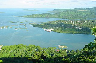
Kolonia is a coastal town and the capital of Pohnpei State in the Federated States of Micronesia (FSM). It was also the former FSM capital before being replaced by Palikir in 1989, located nearby to the southwest in the municipality of Sokehs. It has 6,074 people.

The College of Micronesia-FSM (COM-FSM) is a public community college in the Federated States of Micronesia. It began operation in 1963 as the Micronesian Teacher Education Center.

Xavier High School is a private Catholic coeducational high school run by the USA East Province of the Society of Jesus on the island of Weno in Chuuk, Federated States of Micronesia. It was established by the Jesuits in 1952. It was the first high school in the Trust Territory of the Pacific Islands. Bishop Thomas Feeney, S.J., D.D. from the New York Province of the Society of Jesus originally envisioned a minor seminary to train local clergy. Soon after, Xavier Seminary became the first college preparatory school in the Western Pacific.
Japanese settlement in what constitutes the present-day Federated States of Micronesia (FSM) dates back to the end of the 19th century, when Japanese traders and explorers settled on the central and eastern Carolines, although earlier contacts can not be completely excluded. After Japan occupied the islands in 1914, Japanese migrated to the Carolines on a large scale in the 1920s and 1930s. The Japanese government encouraged immigration to the islands belonging to the South Seas Mandate in order to offset demographic and economic problems facing Japan at that time.

The Catholic Belltower is a historic tower at the Catholic Mission in Kolonia, on the island of Pohnpei in the Federated States of Micronesia. The belltower and adjoining masonry apse are all that remain of a church built in 1909 by German Capuchin missionaries, when Ponape and the other Caroline Islands were administered as part of German New Guinea. The rest of the church was destroyed during the fighting of World War II. The tower is 4.8 metres (16 ft) square, rising to a height of 20.7 metres (68 ft), and the shell of the apse is about 10 metres (33 ft) in height. The tower has a foundation of basalt rock and lime mortar, and is constructed out of concrete bricks.
The Japanese Lighthouse, or Poluwat Lighthouse, is an abandoned lighthouse situated on Alet Island in Poluwat, Chuuk in the Federated States of Micronesia. It was completed in 1940 by the Japanese and was in use until being attacked by U.S. forces in World War II. It was listed on the National Register of Historic Places in 1983. The lighthouse is a good example of pre-World War II "marine architecture" built by the Japanese.
The Chief Agriculturist House is a historic house in Kolonia, the capital of Pohnpei State in the Federated States of Micronesia. It is a steel and concrete structure, built in the mid-1920s when Pohnpei and the other Caroline Islands were part of the Japanese South Seas Mandate. It was one of the highest-quality buildings constructed on Pohnpei during the Japanese administration, and was the home of the Japanese weatherman and agricultural overseer, said to be the second most powerful figure in Japanese Micronesia.
The World War II Japanese Army Headquarters for the defense of Tonowas, an island in what is now Chuuk State in the Federated States of Micronesia, was located in an underground bunker in the village of Roro. The underground facilities, including an office, communications center, print shop, supply room, and health clinic, were built in response to American air raids against the facilities, which were associated with the major naval facility of the Imperial Japanese Navy in Chuuk Lagoon.
The German Cemetery is a historic cemetery in Kolonia, the capital of Pohnpei State in the Federated States of Micronesia. Pohnpei and the other Caroline Islands had become a German protectorate in 1899, after the Spanish–American War, and were administered as part of German New Guinea. This cemetery is a historical reminder of the period of German administration, although it was in deteriorated condition in 1976, accessible only by hiking through a mangrove swamp, with its wrought iron fence and gate in disrepair. Two German governors were buried here.
The Japanese Hydro-electric Power Plant is a former hydroelectric power generation plant and historic site in Kolonia, the capital of Pohnpei State in the Federated States of Micronesia. The site is historically and culturally important as a representative of three different eras in the island's history. The site is important in the culture of Pohnpei as a location of high-quality stones gathered for use in ritual ceremonies involving the pounding of kava and drinking preparations from the plant. In the early 1900s, when Pohnpei was administered as part of German New Guinea, the German administration established an experimental forest, planting a diversity of trees from around the world, some of which continue to thrive in the area. Finally, in the 1920s, during the Japanese South Seas Mandate, a hydroelectric facility was built here. When the property was listed on the United States National Register of Historic Places in 1976 the concrete power plant building and water catchment basin survived.
The Japanese Shrine is a Shinto shrine in Kolonia, the capital of Pohnpei State in the Federated States of Micronesia. The official name at that time was "Nan'yō Government Ponape National School Ho an den".
The Japanese Artillery Road and Pohndolap Area are a historic area on Sokehs Island in the Federated States of Micronesia. Sokehs has a prominent north-south ridge (known locally as "Pohndolap", overlooking the state capital Kolonia, and was fortified by the Japanese during World War II. They built a road to the summit area and emplaced anti-aircraft guns on the ridge. The ridge was also a key site in the 1910 Sokehs Rebellion against Japanese rule, and the remnants of a Pohnpeian fort are also in the area. The surviving elements of these fortifications were listed on the United States National Register of Historic Places in 1976. The old road is now part of a hiking trail, leading up to the fortifications.
The Spanish Wall is the deteriorating remnant of Spanish Fort Alphonso XIII in Kolonia, the capital of Pohnpei State in the Federated States of Micronesia. When built, the wall was about 0.5 miles (0.80 km) in length and 8 feet (2.4 m) in height with a parapet that ranged in height from 2–3 feet (0.61–0.91 m). The wall was built by Spanish administrators of Pohnpei in 1887 after a local uprising drove the local Spanish authorities onto a ship in the harbor. Most of the wall was taken down by the German administration that took over in the early 20th century, after the Spanish–American War. The remains of the wall, about 700 feet (210 m) and two arches, are now part of a local park.
The Sokehs Mass Grave Site is the location where fifteen participants of the 1910/1911 Sokehs Rebellion on the island of Pohnpei were buried by German colonial authorities. The rebellion broke out in October 1910 on Sokehs Island and was suppressed by German naval forces by early 1911. At a summary trial of 36 Sokehs rebels, 17 were convicted of murder and insurrection, and 15 subsequently executed by firing squad and buried in this mass grave. All members of the Sokehs tribe were then exiled to Babelthuap. The mass grave site is a roughly square area 16 feet (4.9 m) on each side, surrounded by a low stone wall. The site is now identified by a memorial marker.
