List of Arizona state parks

Last updated

USA Arizona location map.svg
Red pog.svg
Alamo Lake
Red pog.svg
Buckskin Mountain
Red pog.svg
Catalina
Red pog.svg
Cattail Cove
Red pog.svg
Dead Horse Ranch & Verde River
Red pog.svg
Fool Hollow Lake
Red pog.svg
Fort Verde
Red pog.svg
Granite Mountain Hotshots
Red pog.svg
Homolovi
Red pog.svg
Jerome
Red pog.svg
Kartchner Caverns
Red pog.svg
Lake Havasu
Red pog.svg
Lost Dutchman
Red pog.svg
Lyman Lake
Red pog.svg
McFarland
Red pog.svg
Oracle
Red pog.svg
Patagonia Lake
Red pog.svg
Picacho Peak
Red pog.svg
Red Rock
Red pog.svg
Riordan Mansion
Red pog.svg
Roper Lake
Red pog.svg
San Rafael Ranch
Red pog.svg
Slide Rock
Red pog.svg
Sonoita Creek
Red pog.svg
Tombstone Courthouse
Red pog.svg
Tonto Natural Bridge
Red pog.svg
Tubac Presidio
Red pog.svg
Yuma Quartermaster Depot
Red pog.svg
Yuma Prison
Location of state parks within Arizona

An Arizona state park is an area of land in the U.S. state of Arizona preserved by the state for its natural, cultural, or recreational resources. The state park system in Arizona includes both state parks and state historic parks, as well as other designations such as natural areas and recreation areas. Arizona currently has 31 state park units, which are managed wholly or partly by the Arizona State Parks government agency. [1] In 2010 several Arizona state parks were closed due to budget cuts. Some have since reopened thanks to support in the form of donations and partnerships with local agencies. [2]

Contents

List

Park nameCountySize [lower-alpha 1] Elevation [lower-alpha 1] Established [lower-alpha 1] Remarks [lower-alpha 1] Photography
acreshaftm
Alamo Lake State Park La Paz & Mohave 4,9002,0001,3004001969Features a remote reservoir on the Bill Williams River with premiere bass fishing and stargazing Alamo Lake and Artillery Peak.jpg
Buckskin Mountain State Park La Paz 1,6776794201301967Provides water recreation on the Colorado River in the Parker Valley
Catalina State Park Pima 5,4932,2232,6508101974Preserves a diverse desert landscape at the foot of the Santa Catalina Mountains Catalinastateparkbyandruvalpy.jpg
Cattail Cove State Park Mohave 2,0008104501401970Provides water recreation on Lake Havasu
Dead Horse Ranch State Park Yavapai 4231713,3001,0001972Provides outdoor recreation along the Verde River Dead Horse Ranch.jpg
Fool Hollow Lake Recreation Area Navajo 8003206,3001,9001994Surrounds a 150-acre (61 ha) mountain reservoir
Fort Verde State Historic Park Yavapai 114.53,2609901970Interprets the best-preserved Indian Wars-era fort in Arizona, active from 1871–1891 Fort Verde 02.jpg
Granite Mountain Hotshots Memorial State Park Yavapai 3201304,318–5,4601,316–1,6642016Memorial to the nineteen members of the Granite Mountain Hotshots who died there on June 30, 2013 while fighting the Yarnell Hill Fire
Homolovi State Park Navajo 4,5001,8004,9001,5001986Preserves several pueblo ruins and other Ancestral Puebloan archaeological sites
Jerome State Historic Park Yavapai |5,0001,5001957Honors the Douglas family of mining entrepreneurs in their 1916 adobe mansion Douglas Mansion.jpg
Kartchner Caverns State Park Cochise |4,7001,4001988Preserves a limestone cave kept in near-pristine condition since its discovery in 1974
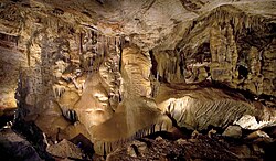
 Kartchner Big Room.jpg
Lake Havasu State Park Mohave 9283764801501965Provides water recreation on Lake Havasu
Lost Dutchman State Park Pinal 3201302,0006101977Faces the Superstition Mountains, where the Lost Dutchman's Gold Mine is said to be hidden
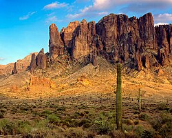
 SUPERSTITIONS AZ15.jpg
Lyman Lake State Park Apache 1,2004906,0001,8001960Features Lyman Reservoir and a 14th Century pueblo ruin LymanLake01a.jpg
McFarland State Historic Park Pinal |1,5004601974Preserves a courthouse and jail from the Arizona Territory era Courtroom, old Pinal courthouse.jpg
Oracle State Park Pinal 3,9481,5983,7001,1001986Features an environmental learning center, a historic ranchhouse, and wildlife habitat in the foothills of the Santa Catalina Mountains
Patagonia Lake State Park Santa Cruz 2,6581,0763,7501,1401974Provides recreational opportunities on 265-acre (107 ha) Patagonia Lake
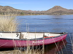
 Plsp-boat.jpg
Picacho Peak State Park Pinal 3,7471,5162,0006101965Features a distinctive 3,374-foot (1,028 m) peak and spring wildflowers Picacho Peak.JPG
Red Rock State Park Yavapai 2861163,9001,2001986Preserves a section of scenic red rock canyon Red Rock State Park, AZ.jpg
Riordan Mansion State Historic Park Coconino 52.06,9002,1001978Interprets the 1904 adjoined homes of influential lumber-baron brothers Timothy and Michael Riordan Riordan state park flagstaff arizona.jpg
Roper Lake State Park Graham 3381373,1309501972Features a 32-acre (13 ha) fishing reservoir and a pond fed by a natural hot spring Roper1-kmf.JPG
San Rafael State Natural Area Santa Cruz 3,5571,4394,7501,4501999Preserves a native grassland largely free of invasive plants. A former ranch complex is now a district on the National Register of Historic Places Not open to the public San Rafael Valley Arizona 2014.JPG
Slide Rock State Park Coconino 43174,9301,5001985Features a natural waterslide and a historic apple orchard in Oak Creek Canyon Slide Rock State Park in snow.jpg
Sonoita Creek State Natural Area Santa Cruz 9,5843,8793,7501,1401994Preserves a diverse transition zone around Sonoita Creek adjacent to Patagonia Lake State Park
Tombstone Courthouse State Historic Park Cochise |4,5391,3831959Preserves the historic 1882 courthouse, sheriff's office, and jail Tombstone-courthouse-shp-courtroom.jpg
Tonto Natural Bridge State Park Gila 161654,5301,3801969Features the world's largest natural arch made of travertine
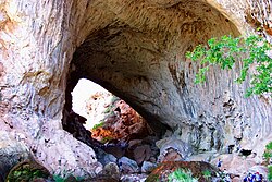
 Tonto Natural Bridge.JPG
Tubac Presidio State Historic Park Santa Cruz |3,5001,1001958Preserves the ruins of the 1753 Presidio San Ignacio de Tubac, an 1885 schoolhouse, and other structures plus a museum Jbda-trail-az-3.jpg
Verde River Greenway State Natural Area Yavapai 4801903,3001,0001986Preserves a 6-mile (9.7 km) section of the Verde River adjacent to Dead Horse Ranch State Park
Yuma Quartermaster Depot State Historic Park Yuma |120371997Interprets an 1864 U.S. Army facility that supplied 14 military posts around the Southwest Warehouse yumaquartermasterdepot.jpg
Yuma Territorial Prison State Historic Park Yuma |120371960Interprets the famous Arizona Territory prison that operated from 1876 to 1909 Yuma prison main guard tower.jpg

See also

Notes

  1. 1 2 3 4 All data come from respective park webpages unless otherwise noted.

Related Research Articles

<span class="mw-page-title-main">Imperial County, California</span> County in California, United States

Imperial County is a county located on the southeast border of the U.S. state of California. As of the 2020 census, the population was 179,702, making it the least populous county in Southern California. The county seat is El Centro. Imperial is the most recent California county to be established, as it was created in 1907 out of portions of San Diego County.

<span class="mw-page-title-main">Maricopa County, Arizona</span> County in Arizona, United States

Maricopa County is in the south-central part of the U.S. state of Arizona. As of the 2020 census the population was 4,420,568, or about 62% of the state's total, making it the fourth-most populous county in the United States, the most populous county in Arizona, and making Arizona one of the nation's most centralized states. The county seat is Phoenix, the state capital and fifth-most populous city in the United States.

<span class="mw-page-title-main">Yavapai County, Arizona</span> County in Arizona, United States

Yavapai County is near the center of the U.S. state of Arizona. As of the 2020 census, its population was 236,209, making it the fourth-most populous county in Arizona. The county seat is Prescott.

<span class="mw-page-title-main">Yuma County, Arizona</span> County in Arizona, United States

Yuma County is a county in the southwestern corner of the U.S. state of Arizona. As of the 2020 census, its population was 203,881. The county seat is Yuma.

<span class="mw-page-title-main">Colorado River</span> Major river in the western United States and Mexico

The Colorado River is one of the principal rivers in the Southwestern United States and in northern Mexico. The 1,450-mile-long (2,330 km) river drains an expansive, arid watershed that encompasses parts of seven U.S. states and two Mexican states. The name Colorado derives from the Spanish language for "colored reddish" due to its heavy silt load. Starting in the central Rocky Mountains of Colorado, it flows generally southwest across the Colorado Plateau and through the Grand Canyon before reaching Lake Mead on the Arizona–Nevada border, where it turns south toward the international border. After entering Mexico, the Colorado approaches the mostly dry Colorado River Delta at the tip of the Gulf of California between Baja California and Sonora.

<span class="mw-page-title-main">Gila River</span> River in New Mexico and Arizona, United States

The Gila River is a 649-mile-long (1,044 km) tributary of the Colorado River flowing through New Mexico and Arizona in the United States. The river drains an arid watershed of nearly 60,000 square miles (160,000 km2) that lies mainly within the U.S., but also extends into northern Sonora, Mexico.

<span class="mw-page-title-main">Colorado Plateau</span> Plateau in the Four Corners region of the Southwest United States

The Colorado Plateau, also known as the Colorado Plateau Province, is a physiographic and desert region of the Intermontane Plateaus, roughly centered on the Four Corners region of the southwestern United States. This province covers an area of 336,700 km2 (130,000 mi2) within western Colorado, northwestern New Mexico, southern and eastern Utah, northern Arizona, and a tiny fraction in the extreme southeast of Nevada. About 90% of the area is drained by the Colorado River and its main tributaries: the Green, San Juan, and Little Colorado. Most of the remainder of the plateau is drained by the Rio Grande and its tributaries.

<span class="mw-page-title-main">Verde River</span> Perennial stream in central Arizona, US

The Verde River is a major tributary of the Salt River in the U.S. state of Arizona. It is about 170 miles (270 km) long and carries a mean flow of 602 cubic feet per second (17.0 m3/s) at its mouth. It is one of the largest perennial streams in Arizona.

North Central Arizona is a geographical region of Arizona. It is in the Transition Zone between the Basin and Range Province and the Colorado Plateau, and has some of the most rugged and scenic landscapes in Arizona.

<span class="mw-page-title-main">Index of Arizona-related articles</span>

The following is an alphabetical list of articles related to the U.S. state of Arizona.

<span class="mw-page-title-main">Yuma Crossing</span> United States historic place

Yuma Crossing is a site in Arizona and California that is significant for its association with transportation and communication across the Colorado River. It connected New Spain and Las Californias in the Spanish Colonial period in and also during the Western expansion of the United States. Features of the Arizona side include the Yuma Quartermaster Depot and Yuma Territorial Prison. Features on the California Side include Fort Yuma, which protected the area from 1850 to 1885.

<span class="mw-page-title-main">Bill Williams River</span> River in Arizona

The Bill Williams River is a 46.3-mile-long (74.5 km) river in west-central Arizona where it, along with one of its tributaries, the Santa Maria River, form the boundary between Mohave County to the north and La Paz County to the south. It is a major drainage westwards into the Colorado River of the Lower Colorado River Valley south of Hoover Dam and Lake Mead, and the drainage basin covers portions of northwest, and west-central Arizona. The equivalent drainage system paralleling the east–west lower reaches of the Bill Williams is the Gila River, which flows east-to-west across central Arizona, joining the Colorado River in the southwest at Yuma. The confluence of the Bill Williams River with the Colorado is north of Parker, and south of Lake Havasu City.

<span class="mw-page-title-main">Maricopa County Sheriff's Office</span> Law enforcement agency in Arizona, United States

The Maricopa County Sheriff's Office (MCSO) is the law enforcement agency that serves Maricopa County, Arizona, and is the largest sheriff's office in Arizona. The MCSO provides patrol services and criminal investigation to unincorporated areas of the county and operates the county jail system. It also serves as the primary law enforcement agency for any incorporated cities within the county that have contracted with the agency for law-enforcement services. The county sheriff is elected by the citizens and serves as the highest law enforcement official in Maricopa County. The current Sheriff of Maricopa County is Paul Penzone, elected in 2016. As a result of policies and practices under former sheriff Joe Arpaio the MCSO has received significant critical media coverage, federal investigation, and judicial oversight.

<span class="mw-page-title-main">Geography of Arizona</span> Geographical features of Arizona

Arizona is a landlocked state situated in the southwestern region of the United States of America. It has a vast and diverse geography famous for its deep canyons, high- and low-elevation deserts, numerous natural rock formations, and volcanic mountain ranges. Arizona shares land borders with Utah to the north, the Mexican state of Sonora to the south, New Mexico to the east, and Nevada to the northwest, as well as water borders with California and the Mexican state of Baja California to the southwest along the Colorado River. Arizona is also one of the Four Corners states and is diagonally adjacent to Colorado.

<span class="mw-page-title-main">Parker Valley</span> Landform within the Lower Colorado River Valley

The Parker Valley is located along the Lower Colorado River within the Lower Colorado River Valley region, in southwestern Arizona and southeastern California.

<span class="mw-page-title-main">Trail of the Ancients</span> National Scenic Byways in Arizona, Colorado, New Mexico, and Utah, United States

The Trail of the Ancients is a collection of National Scenic Byways located in the U.S. Four Corners states of Utah, Colorado, New Mexico, and Arizona. These byways comprise:

The Great Western Trail is a north-south long distance multiple use route which runs from Canada to Mexico through five western states in the United States. The trail has access for both motorized and non-motorized users and traverses 4,455 miles (7,170 km) through Arizona, Utah, Idaho, Wyoming, and Montana. It was designated a National Millennium Trail in 1999.

<span class="mw-page-title-main">Course of the Colorado River</span> Route and confluences of the Colorado River in the United States and Mexico

The Colorado River is a major river of the western United States and northwest Mexico in North America. Its headwaters are in the Rocky Mountains where La Poudre Pass Lake is its source. Located in north central Colorado it flows southwest through the Colorado Plateau country of western Colorado, southeastern Utah and northwestern Arizona where it flows through the Grand Canyon. It turns south near Las Vegas, Nevada, forming the Arizona–Nevada border in Lake Mead and the Arizona–California border a few miles below Davis Dam between Laughlin, Nevada and Needles, California before entering Mexico in the Colorado Desert. Most of its waters are diverted into the Imperial Valley of Southern California. In Mexico its course forms the boundary between Sonora and Baja California before entering the Gulf of California. This article describes most of the major features along the river.

References

  1. Arizona State Parks (2010). "Arizona State Parks". Arizona State Parks. Retrieved October 8, 2010.
  2. Arizona State Parks (2010). "Arizona's Rural Communities Rescue State Parks from Closures. Good News! 23 Arizona State Parks will Stay Open". Arizona State Parks. Retrieved October 8, 2010.