
The Mohave Valley is a valley located mostly on the east shore of the south-flowing Colorado River in northwest Arizona. The valley extends into California's San Bernardino County; the northern side of the valley extends into extreme southeast Clark County, Nevada. The main part of the valley lies in southwest Mohave County, Arizona and is at the intersection of the southeast Mojave and northwest Sonoran deserts.
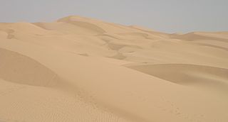
The Yuma Desert is a lower-elevation section of the Sonoran Desert in the southwestern United States and the northwest of Mexico. It lies in the Salton basin. The desert contains areas of sparse vegetation and has notable areas of sand dunes. With an average rainfall less than 8 inches (200 mm) each year, this is among the harshest deserts in North America. Human presence is sparse throughout, the largest city being Yuma, Arizona, on the Colorado River and the border of California.

The Big Maria Mountains are located in the southeastern part of the U.S. state of California, near the Colorado River and Arizona. The range lies between Blythe and Vidal, and west of U.S. Route 95 in California and east of Midland. The mountains are home to the Eagle Nest Mine and reach an elevation of 1,030 meters, (3,379 ft). A power line that runs from Parker Dam to Yuma, Arizona runs through the range. A smaller range, the Little Maria Mountains, lie to the west of the Big Marias.

The La Posa Plain is a wide, generally flat plain in western Arizona near the Colorado River and is on the west and northwest border of the Kofa National Wildlife Refuge. The plain lies to the east of the Colorado River Indian Reservation and east of the Dome Rock and Trigo Mountains. Quartzsite, Arizona, lies on the western part of the plain, which crosses both Interstate 10 and U.S. Route 95.
The Sacramento Mountains are a mountain range in the Eastern Mojave Desert and within Mojave Trails National Monument, in San Bernardino County, California.

The Lower Colorado River Valley (LCRV) is the river region of the lower Colorado River of the southwestern United States in North America that rises in the Rocky Mountains and has its outlet at the Colorado River Delta in the northern Gulf of California in northwestern Mexico, between the states of Baja California and Sonora. This north–south stretch of the Colorado River forms the border between the U.S. states of California/Arizona and Nevada/Arizona, and between the Mexican states of Baja California/Sonora.
The Black Mountains of northwest Arizona are an extensive, mostly linear, north-south trending 75 miles (121 km) long mountain range. It forms the north-south border of southwest Mohave County as it borders the eastern shore of the south-flowing Colorado River from Hoover Dam.

The Muggins Mountains is a mountain range in southwest Arizona east of Yuma, Arizona, northeast of the Gila Mountains, and east of the Laguna Mountains. The Castle Dome Mountains lie to the northeast across the broad Castle Dome Plain. The Muggins Mountains Wilderness occupies the southwest portion of the range.

The Gila Mountains of Yuma County are a 26-mile (42 km) long mountain range in southwestern Arizona in the northwest Sonoran Desert.
The San Cristobal Wash is an ephemeral wash and watercourse of the San Cristobal Valley, flowing north into the Gila River Valley of the southwestern desert region of Arizona. Besides Death Valley, the Chihuahuan Desert area, and regions of Baja Peninsula North America, the southeast California deserts along the Lower Colorado River Valley, this drainage region is in the harshest desert regions of North America.

The Imperial Reservoir is an artificial lake formed by the construction of the Imperial Diversion Dam across the Colorado River in the Lower Colorado River Valley of Imperial County, California, and Yuma County, Arizona. A component of the Imperial National Wildlife Refuge, the reservoir is 16 miles (26 km) northeast of Yuma, Arizona.

Bouse Wash is one of the larger eastern-bank dry washes that enter the Colorado River in the Lower Colorado River Valley. It is located in La Paz County, extreme western Arizona.
The Dome Rock Mountains are a mountain range in southern La Paz County, Arizona. The range borders the Colorado River on the west and the Colorado River Indian Reservation on the northwest located in the Lower Colorado River Valley. Quartzsite, Arizona lies on the eastern foothills of the range.
Tyson Wash is one of the larger eastern-bank dry washes that enter the Colorado River in western Arizona. It drains the La Posa Plain south-to-north and is also coincident with the Plain,.

The Altar Valley is a 45-mile (72 km) long north-south valley, trending slightly northeast from Sasabe, Arizona on the Mexico border to the Avra Valley west of the Tucson Mountains. It is delimited by Arizona State Route 86, from east-to-west on the north separating it from the Avra Valley which then trends northwesterly, merging into the plains and drainage of the Santa Cruz River.

The Piute Wash of extreme southeastern Nevada and northeast San Bernardino County California is the south-flowing drainage of the Piute Valley. The wash and valley are located northwest of Needles, California.

The Granite Wash Mountains are a short, arid, low elevation mountain range of western-central Arizona, in the southeast of La Paz County. The range borders a slightly larger range southeast, the Little Harquahala Mountains; both ranges form a section on the same water divide between two desert washes. The washes flow in opposite directions, one northwest to the Colorado River, the other southeast to the Gila River.
Vidal Valley is a 20-mile (32 km) long valley in the far eastern Colorado Desert bordering the Colorado River. Most of the valley is in eastern San Bernardino County, California, but the outfall on the Colorado River is in northeast Riverside County. Vidal Valley forms the large border of the south side of the east-west block of the Whipple Mountains massif, the landform that forces the Colorado to flow southeast, then back southwest. The southeast exit of the valley into Parker Valley on the Colorado River skirts the north end of the Riverside Mountains. The Colorado River Aqueduct crosses the midpoint of the valley at Vidal Junction, California. The Vidal Valley also lies due east of the Danby Dry Lake landform.

The Colorado River is a major river of the western United States and northwest Mexico in North America. Its headwaters are in the Rocky Mountains where La Poudre Pass Lake is its source. Located in north central Colorado it flows southwest through the Colorado Plateau country of western Colorado, southeastern Utah and northwestern Arizona where it flows through the Grand Canyon. It turns south near Las Vegas, Nevada, forming the Arizona–Nevada border in Lake Mead and the Arizona–California border a few miles below Davis Dam between Laughlin, Nevada and Needles, California before entering Mexico in the Colorado Desert. Most of its waters are diverted into the Imperial Valley of Southern California. In Mexico its course forms the boundary between Sonora and Baja California before entering the Gulf of California. This article describes most of the major features along the river.

The Toroweap Fault of northwest Arizona and southwest Utah is part of a fault system of the west Grand Canyon region, Arizona, USA; also the west perimeter regions of the Coconino and Colorado Plateaus. The Hurricane Fault originates at the Toroweap Fault, in the region of the Colorado River, and strikes as the westerly depression of the Toroweap Fault. The Toroweap strikes northerly from the Colorado at the east of Toroweap Valley, and enters south Utah; from the Colorado River, the Hurricane Fault strikes north-northwest along the west flank of the small, regional Uinkaret Mountains, the west border of Toroweap Valley. The Hurricane Fault, and the Hurricane Cliffs strike into southwest Utah as part of the west, and southwest perimeter of the Colorado Plateau. The Hurricane Cliffs are made of Kaibab Limestone, an erosion resistant, cliff-forming rock unit.


