Yuma Project

Last updated • 9 min readFrom Wikipedia, The Free Encyclopedia
Laguna Diversion Dam LagunaDiversionDamoh.jpg
Laguna Diversion Dam

The Yuma Project is a U.S. Bureau of Reclamation project built to irrigate over 68,000 acres (280 km2) of land in Yuma County, Arizona and parts of Imperial County, California. The project is designed to exploit year-round farming conditions and water from the Colorado River. It consists of the Laguna Diversion Dam, pumping plants, a power plant, a 53-mile (85 km) system of canals, 218 miles (351 km) of lateral canals, levees and drains. The project began in 1903 and the majority of the work was completed by 1915. It was the first dam and reclamation project on the Colorado River and workers had to overcome many natural and logistical obstacles to build and maintain it. The Laguna Diversion Dam was replaced by the Imperial Dam as the Project's water source between 1941 and 1948. Today, it serves 275 farms and over 94,000 people.

Contents

Background and layout

Although temperatures in the southern areas of Arizona and California tend to be hot and precipitation averages 3.5 inches (89 mm) a year, the region features a year-round farming season and the Colorado River. The Bureau of Reclamation and the Yuma County Water Users' Association wanted to exploit these conditions and create a large area of irrigation-fed farming. The project would be split into two divisions, the Valley Division in Yuma County, Arizona and the Reservation Division in Imperial County, California. The Reservation Division was further broken down into the Bard Unit and the Indian Unit. The Reservation Division and Bard Unit occupy much of what was Fort Yuma Indian Reservation. [1]

History and construction

Yuma Project construction office YumaProjectConstructionOffice.jpg
Yuma Project construction office

In 1854, the United States purchased the future Yuma Project's land in the Gasden Purchase but had created the Fort Yuma Indian Reservation in 1884 to settle the indigenous Quechan people. Much of the land was disputed in the 1890s and in 1910, the Dawes Severalty Act opened the land to white settlers which led to further disputes. A series of court battles between the United States and the landholders led to the United States winning a decision and acquiring the land in 1898. [1]

Farmers immediately began constructing gravity-fed irrigation systems in the area which proved inconsistent and ultimately ineffective. In 1902, the Reclamation Act was passed, allotting funds for western farm development and creating the U.S. Bureau of Reclamation (known as the Reclamation Service until 1923). Subsequently, in 1903, U.S. President Theodore Roosevelt turned the entire Fort Yuma Indian Reservation over to the Bureau of Reclamation for development. Future farmers in the area formed the Yuma County Water Users' Association later in 1903 and in 1904, U.S. Secretary of the Interior Ethan A. Hitchcock authorized the Yuma Project. [1]

Laguna Dam

Sluice gate on the Arizona-side of the Laguna Diversion Dam, 1909 LagunaDamArizonaSluiceGate.jpg
Sluice gate on the Arizona-side of the Laguna Diversion Dam, 1909

The Bureau of Reclamation with project engineer Francis L. Sellew, immediately began purchasing the necessary lands and began the project with the Laguna Diversion Dam on the Colorado River. On July 6, 1905 the contract to build the dam was awarded to J. G. White and Company who started construction less than two weeks later. Deliveries of cement were a problem as they had to be delivered to Yuma by rail and to the construction site by wagons or steamboat. Poor rock quality at local quarries also posed a problem that consistently delayed construction, 50% of the weak rock was unusable. Even after their contract was supplemented to encompass the rock quality delays, J. G. White and Company still did not meet their deadline and the Bureau of Reclamation took over construction in early 1907. [1]

To solve the cement delivery problems, by March 1908, the Bureau of Reclamation built a levee on the California side on the dam that was topped by a rail-line. Beforehand, they had also gained the cooperation of the Southern Pacific Railroad who agreed to deliver cement directly at the dam site. The rock quality problem was solved when the Bureau raised the upstream and downstream cofferdams with rock waste and topped them with rail lines that could deliver rock-fill much faster. By December 1908, the water bypass around the dam was complete and workers began to pour the rock-fill. Three large concrete walls supported by 6-inch (150 mm) sheet-wood pilings were built across the river for the dam's foundation. Rock-fill was placed in between and on the outsides of these walls for support. The California sluiceway consisted of three iron gates while the Arizona had one. Mexican-Americans mostly worked on the dam while a few Native American Indians did as well. White-labor worked in the cooler months. [1]

Canals

A Bell-type turbine being installed at the Siphon Drop Spillway power plant Propeller Turbine.jpg
A Bell-type turbine being installed at the Siphon Drop Spillway power plant

Construction on the Yuma Canal which branched off the California side of the Laguna Dam began in 1909. One and half miles from the dam, at Indian Heading, the Yuma Canal splits into the Reservation Main Canal and the Yuma Main Canal. The Yuma Main Canal continues 10.5 miles (16.9 km) southwest until it reaches the 9.9-foot (3.0 m) Siphon Drop Spillway where a power plant was later built in 1926. After another 3.5 miles (5.6 km), it reaches the Colorado River Siphon which siphons the water under the Colorado River. After it reaches Yuma, it split into the East and West Main canals to pass through the Valley Division and to the Mexican border. The Yuma Main Canal along with the East Main Canal and part of the West Main Canal were complete by 1912. The rest of the West Main Canal started again in 1913 and was completed in 1915. [1]

Work on the Reservation Main Canal began in 1907 and its adjacent lateral canals began in 1908. The Mojave and Cocopah Canals were constructed as splits off the Reservation Canal. Construction on the Colorado River Siphon began in 1909 and would initially consist of a 50-foot (15 m) inverted siphon that transfers water via the Yuma Main Canal to the Valley Division. Construction on the siphon was halted in February 1911 after the surrounding sandstone proved too porous and unstable. The Bureau of Reclamation decided to use pneumatic compressed air to finish the construction which sank the siphon further to 76 feet (23 m) and it began to operate on June 29, 1912. In total, the Yuma Project contained 53 miles (85 km) of canal and 218 miles (351 km) of lateral canal. [1]

Drains

A system of drains, and in some areas wells, were incorporated throughout the project. They drain farming run-off and excess water from the irrigated areas. The Reservation Division's drains discharge directly into the Colorado River and nearly one half of them are intended to intercept leaks from the nearby All-American Canal. In the Valley Divisions, the drains run through its central part while wells exist in the east. All drainage is removed at the Boundary Pumping Station which began operating in 1919. [2]

Levees

A system of levees was also constructed between 1907-1909 in order to protect the banks of the Colorado River from flooding and its historical course-changing meandering. The Reservation levee was constructed on the west bank of the river between Lagunato and Araz. The Yuma Valley levees were on the east bank of the river until the Colorado-Gila River confluence and then to the Mexican border. To maintain the levees, the Bureau of Reclamation built rail lines on top of the Reservation levee so rail cars could reinforce or fill in problem areas. This proved successful during a major flood in 1912 and the Bureau asked Southern Pacific Railway if another line could be built on the Yuma Valley levee but they were reluctant. With its own acquired funding, the Bureau began to construct the Yuma Valley Railway in May 1914 and despite hot temperatures and wage strikes, construction was completed in February 1915. [1]

Yuma Auxiliary Project

Prior to completing the Laguna Diversion Dam, the Bureau of Reclamation began to consider the Yuma Auxiliary Project which would supplement the Yuma Project in order to irrigate another 45,000 acres (180 km2) of land called Yuma Mesa. Initial surveys of the Mesa began in 1916 and the US Congress approved the Project in 1917. The Project was broken down in units A, B, C and D. Construction began on September 27, 1920 with the Mesa Supply Canal for unit B and in May 1922, the unit's pumping station was also complete. Unit B irrigated as much as 3,000 acres (12 km2) but development of the other three units never materialized. Only 3.6 miles (5.8 km) of canal and 10 miles (16 km) of lateral canals were built. In 1949, after the Laguna Dam ceased to divert water, the Yuma Auxiliary Project was reduced to just over 3,300 acres (13 km2) in sized and the Gila Project took over its water supply. [1]

Maintenance and the Imperial Dam change

Damage to a canal structure after the 1940 earthquake 1940YumaProjectDamage.jpg
Damage to a canal structure after the 1940 earthquake

Flooding continued to be a problem for the Yuma Project. In January 1916, a flood larger than the one in 1912 caused 800 feet (240 m) in breaks on the Reservation Levee as the Gila River reached a maximum flow of 215,000 cubic feet per second (6,100 m3/s). The river again flooded a few days later, reaching a flow of 162,000 cubic feet per second (4,600 m3/s). Afterward, 10,000 of the 16,000-acre (65 km2) Reservation Division was inundated while 3,000 of the Valley Division's 50,000 acres (200 km2) flooded. The floods also displaced 50,000 yards of main canal. The Bureau of Reclamation worked quickly to restore the project in 15 days. In 1918, the Colorado River's meandering damaged part of the Reservation levee and it was repaired slowly with unskilled labor because of World War I's troop demands. The Laguna Diversion Dam weathered the floods but its downstream talus at its toe was extended between 1923 and 1924 to help better protect it. An earthquake on May 18, 1940 damaged the Project considerably, especially the Valley Division. Canals, levees and other features were damaged but repaired by late May. From 1936 through World War II, Civilian Conservation Corps workers, Indians from Mexico, Italian prisoners and German prisoners all worked to maintain the project. [1]

The Boulder Canyon Project Act in 1928 would signal change for the Yuma Project. The Act authorized the construction of the Hoover Dam which curtailed flooding on the Colorado River but it also authorized the All-American Canal and the Imperial Dam. The Imperial Dam would serve as the lower Colorado's diversion dam and would also supply the Yuma Project with water. The dam was completed in 1938 and in 1941, the Bureau of Reclamation sealed off the Yuma Main Canal from the Laguna Diversion Dam. All outlets from the Laguna Dam were sealed on June 23, 1948 allowing for full supply from the Imperial Dam. Becoming obsolete, the Bureau decommissioned the power plant at the Siphon Drop Spillway in 1972. [1]

Irrigation data

The Yuma Project serves 275 farms and over 94,000 people. In 1992, the Project irrigated 58,626 acres (237.25 km2) of land worth $196,105,730 in crops. The Reservation Division receives on average 123 cubic feet per second (3.5 m3/s) of water while the Valley Division receives 937 cubic feet per second (26.5 m3/s). [3]

See also

Related Research Articles

<span class="mw-page-title-main">Colorado River</span> Major river in the western United States and Mexico

The Colorado River is one of the principal rivers in the Southwestern United States and in northern Mexico. The 1,450-mile-long (2,330 km) river, the 5th longest in the United States, drains an expansive, arid watershed that encompasses parts of seven U.S. states and two Mexican states. The name Colorado derives from the Spanish language for "colored reddish" due to its heavy silt load. Starting in the central Rocky Mountains of Colorado, it flows generally southwest across the Colorado Plateau and through the Grand Canyon before reaching Lake Mead on the Arizona–Nevada border, where it turns south toward the international border. After entering Mexico, the Colorado approaches the mostly dry Colorado River Delta at the tip of the Gulf of California between Baja California and Sonora.

<span class="mw-page-title-main">United States Bureau of Reclamation</span> Government agency

The Bureau of Reclamation, formerly the United States Reclamation Service, is a federal agency under the U.S. Department of the Interior, which oversees water resource management, specifically as it applies to the oversight and operation of the diversion, delivery, and storage projects that it has built throughout the western United States for irrigation, water supply, and attendant hydroelectric power generation. It is currently the U.S.'s largest wholesaler of water, bringing water to more than 31 million people, and providing one in five Western farmers with irrigation water for 10 million acres of farmland, which produce 60% of the nation's vegetables and 25% of its fruits and nuts. The Bureau is also the second largest producer of hydroelectric power in the western U.S.

<span class="mw-page-title-main">Gila River</span> River in New Mexico and Arizona, United States

The Gila River is a 649-mile-long (1,044 km) tributary of the Colorado River flowing through New Mexico and Arizona in the United States. The river drains an arid watershed of nearly 60,000 square miles (160,000 km2) that lies mostly within the U.S., but also extends into northern Sonora, Mexico.

<span class="mw-page-title-main">Columbia Basin Project</span> American irrigation project

The Columbia Basin Project in Central Washington, United States, is the irrigation network that the Grand Coulee Dam makes possible. It is the largest water reclamation project in the United States, supplying irrigation water to over 670,000 acres (2,700 km2) of the 1,100,000 acres (4,500 km2) large project area, all of which was originally intended to be supplied and is still classified irrigable and open for the possible enlargement of the system. Water pumped from the Columbia River is carried over 331 miles (533 km) of main canals, stored in a number of reservoirs, then fed into 1,339 miles (2,155 km) of lateral irrigation canals, and out into 3,500 miles (5,600 km) of drains and wasteways. The Grand Coulee Dam, powerplant, and various other parts of the CBP are operated by the Bureau of Reclamation. There are three irrigation districts in the project area, which operate additional local facilities.

<span class="mw-page-title-main">Pick–Sloan Missouri Basin Program</span> Flood control

The Pick–Sloan Missouri Basin Program, formerly called the Missouri River Basin Project, was initially authorized by the Flood Control Act of 1944, which approved the plan for the conservation, control, and use of water resources in the Missouri River Basin.

<span class="mw-page-title-main">All-American Canal</span> Aqueduct in southern California

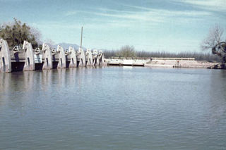
The All-American Canal is an 82-mile-long (132 km) aqueduct, located in southeastern California. It conveys water from the Colorado River into the Yuma Project, the Imperial Valley, and to nine cities. It is the Imperial Valley's only water source, and replaced the Alamo Canal, which was located mostly in Mexico. The Imperial Dam, about 30 miles (48 km) northeast of Yuma, Arizona on the Colorado River, diverts water into the All-American Canal, which runs to just west of Calexico, California before its last branch heads mostly north into the Imperial Valley. Smaller canals branching off the All-American Canal move water into the Yuma Valley and the Imperial Valley. These canal systems irrigate up to 630,000 acres (250,000 ha) of crop land and have made possible a greatly increased crop yield in this area, originally one of the driest on earth. It is the largest irrigation canal in the world, carrying a maximum of 26,155 cubic feet per second (740.6 m3/s). Agricultural runoff from the All-American Canal drains into the Salton Sea.

<span class="mw-page-title-main">Colorado–Big Thompson Project</span> Federal water diversion project

The Colorado–Big Thompson Project is a federal water diversion project in Colorado designed to collect West Slope mountain water from the headwaters of the Colorado River and divert it to Colorado's Front Range and plains. In Colorado, approximately 80% of the state's precipitation falls on the West Slope, in the Rocky Mountains, while around 80% of the state's growing population lives along the eastern slope, between the cities of Fort Collins and Pueblo.

<span class="mw-page-title-main">New Waddell Dam</span> Dam in Maricopa County, Arizona

The New Waddell Dam is an embankment dam on the Agua Fria River in Maricopa County, Arizona, 35 miles (56 km) northwest of Phoenix. It serves as part of the Central Arizona Project (CAP) while also providing water for the Maricopa Water District. The dam creates Lake Pleasant with water from the Agua Fria and also the CAP aqueduct. In addition, it affords flood protection, hydroelectric power production and recreational opportunities. Construction on the dam began in 1985 and ended in 1994. Its reservoir submerged the Old Waddell Dam which was completed in 1927 after decades of planning.

<span class="mw-page-title-main">Laguna Diversion Dam</span> Dam in Arizona, US

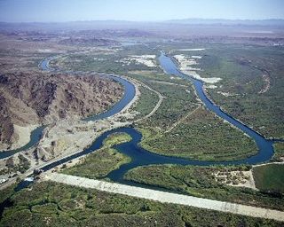
The Laguna Diversion Dam is a rock-filled diversion dam on the Colorado River. It is located 13 miles (21 km) northeast of Winterhaven, CA–Yuma, AZ on Imperial County route S24. Constructed between 1903 and 1905, the dam was the first dam built on the Colorado River and subsequently ended boat travel to the north.

<span class="mw-page-title-main">Shoshone Project</span>

The Shoshone Project is an irrigation project in the U.S. state of Wyoming. The project provides irrigation for approximately 107,000 acres (430 km2) of crops in the Big Horn Basin, fulfilling the vision of local resident and developer Buffalo Bill Cody, who hoped to make the semi-arid basin into agricultural land. Buffalo Bill Dam on the Shoshone River impounds water for the project in Buffalo Bill Reservoir. In addition to its role in irrigation, the project provides flood control on the Shoshone and generates power, using the 350-foot (110 m) height of Buffalo Bill Dam, once a world record, and the considerable fall of the river through Shoshone Canyon to generate hydroelectric power. Chief crops in the Big Horn Basin are sugar beets, alfalfa, barley, oats, corn and beans.

<span class="mw-page-title-main">Navajo Dam</span> Dam in San Juan and Rio Arriba Counties, New Mexico

Navajo Dam is a dam on the San Juan River, a tributary of the Colorado River, in northwestern New Mexico in the United States. The 402-foot (123 m) high earthen dam is situated in the foothills of the San Juan Mountains about 44 miles (71 km) upstream and east of Farmington, New Mexico. It was built by the U.S. Bureau of Reclamation (Reclamation) in the 1960s to provide flood control, irrigation, domestic and industrial water supply, and storage for droughts. A small hydroelectric power plant was added in the 1980s.

<span class="mw-page-title-main">Auburn Dam</span> Dam in Near Auburn, California

Auburn Dam was a proposed concrete arch dam on the North Fork of the American River east of the town of Auburn, California, in the United States, on the border of Placer and El Dorado Counties. Slated to be completed in the 1970s by the U.S. Bureau of Reclamation, it would have been the tallest concrete dam in California and one of the tallest in the United States, at a height of 680 feet (210 m) and storing 2,300,000 acre-feet (2.8 km3) of water. Straddling a gorge downstream of the confluence of the North and Middle Forks of the American River and upstream of Folsom Lake, it would have regulated water flow and provided flood control in the American River basin as part of Reclamation's immense Central Valley Project.

The Central Utah Project is a US federal water project that was authorized for construction under the Colorado River Storage Project Act of April 11, 1956, as a participating project. In general, the Central Utah Project develops a portion of Utah's share of the yield of the Colorado River, as set out in the Colorado River Compact of 1922.

<span class="mw-page-title-main">Rio Grande Project</span>

The Rio Grande Project is a United States Bureau of Reclamation irrigation, hydroelectricity, flood control, and interbasin water transfer project serving the upper Rio Grande basin in the southwestern United States. The project irrigates 193,000 acres (780 km2) along the river in the states of New Mexico and Texas. Approximately 60 percent of this land is in New Mexico. Some water is also allotted to Mexico to irrigate some 25,000 acres (100 km2) on the south side of the river. The project was authorized in 1905, but its final features were not implemented until the early 1950s.

<span class="mw-page-title-main">Klamath Diversion</span>

The Klamath Diversion was a federal water project proposed by the U.S. Bureau of Reclamation in the 1950s. It would have diverted the Klamath River in Northern California to the more arid central and southern parts of that state. It would relieve irrigation water demand and groundwater overdraft in the Central Valley and boost the water supply for Southern California. Through the latter it would allow for other Southwestern states—Arizona, Nevada, New Mexico and Utah—as well as Mexico to receive an increased share of the waters of the Colorado River.

<span class="mw-page-title-main">Minidoka Project</span>

The Minidoka Project is a series of public works by the U.S. Bureau of Reclamation to control the flow of the Snake River in Wyoming and Idaho, supplying irrigation water to farmlands in Idaho. One of the oldest Bureau of Reclamation projects in the United States, the project involves a series of dams and canals intended to store, regulate and distribute the waters of the Snake, with electric power generation as a byproduct. The water irrigates more than a million acres (4,000 km²) of otherwise arid land, producing much of Idaho's potato crop. Other crops include alfalfa, fruit and sugar beets. The primary irrigation district lies between Ashton in eastern Idaho and Bliss in the southwestern corner of the state. Five main reservoirs collect water, distributing it through 1,600 miles (2,600 km) of canals and 4,000 miles (6,400 km) of lateral distribution ditches.

<span class="mw-page-title-main">San Juan–Chama Project</span> Water management project in New Mexico and Colorado

The San Juan–Chama Project is a U.S. Bureau of Reclamation interbasin water transfer project located in the states of New Mexico and Colorado in the United States. The project consists of a series of tunnels and diversions that take water from the drainage basin of the San Juan River – a tributary of the Colorado River – to supplement water resources in the Rio Grande watershed. The project furnishes water for irrigation and municipal water supply to cities along the Rio Grande including Albuquerque and Santa Fe.

<span class="mw-page-title-main">Middle Rio Grande Conservancy District</span>

The Middle Rio Grande Conservancy District (MRGCD) was formed in 1925 to manage the irrigation systems and control floods in the Albuquerque Basin. It is responsible for the stretch of river from the Cochiti Dam in Sandoval County in the north, through Bernalillo County, Valencia County and Socorro County to the Elephant Butte Reservoir in the south. It manages the Angostura, Isleta and San Acacia diversion dams, which feed an extensive network of irrigation canals and ditches.

<span class="mw-page-title-main">Middle Rio Grande Project</span>

The Middle Rio Grande Project manages water in the Albuquerque Basin of New Mexico, United States. It includes major upgrades and extensions to the irrigation facilities built by the Middle Rio Grande Conservancy District and modifications to the channel of the Rio Grande to control sedimentation and flooding. The bulk of the work was done by the United States Bureau of Reclamation and the United States Army Corps of Engineers in the 1950s, but construction continued into the 1970s and maintenance is ongoing. The project is complementary to the San Juan–Chama Project, which transfers water from the San Juan River in the Colorado River Basin to the Rio Grande. Although distribution of water from the two projects is handled through separate allotments and contracts, there is some sharing of facilities including the river itself. The ecological impact on the river and the riparian zone was the subject of extended litigation after a group of environmentalists filed Rio Grande Silvery Minnow v. Bureau of Reclamation in 1999.

<span class="mw-page-title-main">Mesilla Diversion Dam</span> Dam in Doña Ana County, New Mexico

The Mesilla Diversion Dam is located in the Rio Grande about 40 miles (64 km) upstream of El Paso, Texas, about 6 miles (9.7 km) to the south of Las Cruces, New Mexico. It diverts water from the river for irrigation in the lower Mesilla Valley. The dam is owned by the United States Bureau of Reclamation, which built it, and is operated by the Elephant Butte Irrigation District.

References

  1. 1 2 3 4 5 6 7 8 9 10 11 A. Stene, Eric. "YUMA PROJECT AND YUMA AUXILIARY PROJECT" (PDF). History of Reclamation Projects. U.S. Bureau of Reclamation. Retrieved 14 July 2010.
  2. "Yuma Project Details". U.S. Bureau of Reclamation. Retrieved 14 July 2010.
  3. "Yuma Project Data". U.S. Bureau of Reclamation. Retrieved 14 July 2010.

32°49′39″N114°30′0″W / 32.82750°N 114.50000°W / 32.82750; -114.50000