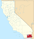
The Imperial Valley (Spanish: Valle de Imperial or Valle Imperial) of Southern California lies in Imperial and Riverside counties, with an urban area centered on the city of El Centro. The Valley is bordered by the Colorado River to the east and, in part, the Salton Sea to the west. Farther west lies the San Diego and Imperial County border. To the north is the Coachella Valley region of Riverside County, which together with Imperial Valley form the Salton Trough, or the Cahuilla Basin, also the county line of Imperial and Riverside counties, and to the south the international boundary with Mexico.
The culture of the area blends those of the United States and Mexico, due to its regional history and geographic location along the international border. The Imperial Valley economy is based on agriculture.
Imperial Valley was named by the Imperial Land Company, in the hopes of attracting settlers. It is now the home of the El Centro metropolitan area. Locally, the terms "Imperial Valley" and "Imperial County" are used synonymously. Imperial Valley is also called Lithium Valley, because of its rich supply of lithium, used to power electric vehicles, cameras, etc.[1][2]
Geography
Bighorns in Anza-BorregoSalton SeaAerial view of Imperial Valley and Salton Sea
The Imperial Valley extends southward for 50 miles (80km) from the southern end of the Salton Sea into Mexico. Part of a trough stretching from the Coachella Valley to the Gulf of California, it is almost entirely below sea level—235 feet (72m) below at the edge of the Salton Sea. Its hot desert climate is characterized by daily temperature extremes. It was once part of the Gulf of California, from which it was cut off by the dam-like deposits of the Colorado River Delta Fan as it carved out the Grand Canyon. Bordered by sand dunes and barren mountains, it was uninhabited until 1901, when the Imperial Canal was opened and diverted Colorado River water into the valley through Mexico. Floodwaters in 1905–07 destroyed the irrigation channels and created the Salton Sea now filled by the New River and irrigation run-off.[3] The rivers in the southern part of the Salton Sea river basin flow south to north.
El Centro is the largest industrial center of the Imperial Valley, being the center of shipping exports as well as being home to retail, transportation, wholesale, and agricultural industries. There are also two international border crossings nearby for commercial and noncommercial vehicles. The city's population was 42,598 at the 2010 census and 44,322 at the 2020 census. The city is 50 feet (20m) below sea level and the largest city in the United States below sea level. Fifty percent of the jobs in El Centro come from the service and retail sector.[when?][citation needed]
Climate
The Imperial Valley often has summer temperatures well over 100°F (38°C), but from late October until mid-April the temperature is relatively mild and sometimes low. During winter months the Valley averages more than eight hours of sunshine a day, receiving the most sunlight of any place in the United States.[4]
Historically, the lowest minimum temperature ever recorded in the Imperial Valley was 16°F (−9°C) on January 22, 1937. The highest maximum temperature ever recorded was 121°F (49°C) on July 28, 1995. The lowest maximum temperature was 42°F (6°C), recorded on January 24, 1949, and the highest minimum temperature was 92°F (33°C) on June 30, 1946. The highest monthly mean temperature was 95.9°F (35.5°C), recorded in August 1969 and the lowest mean temperature was 42.3°F (5.7°C) in February 1939.[4]
The 85-year average annual rainfall is 2.93 inches (74mm) with June being the driest month. The only recorded snowfall in the Valley occurred on December 12, 1932. Snow began falling at 8:45p.m. and by 5 a.m. the next day 2.5 inches (6cm) had been recorded. In the southwest portion of Imperial Valley, 4 inches (10cm) of snow was reported that day. This was the only snowfall on record to cover the entire valley.[4]
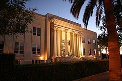
Imperial County Courthouse in El CentroThe Imperial Valley from the highway between Tijuana and Mexicali.
Regions
Imperial Valley can loosely categorize its cities and communities into three regions: the Salton Beach Towns, Desert Cities, and the El Centro area (urbanized Imperial). The Salton Sea Beach Towns have the smallest cities but were resorts in their heyday and have since shrunk in population and size due to the current state of the Salton Sea. The cities and communities of the desert region are outliers in that they are away from urbanized Imperial and tend to be smaller in population than the cities surrounding El Centro. Cities of the El Centro area tend to be larger than those of the desert and Salton regions. And the southeastern end of California is the state's poorest region, with lower-income residents making up over half of the year-round population.[5]
Imperial County's economy consists predominantly of government, agriculture, and retail trade that represents approximately 70% of total county employment.[8] Government services account for over one-third of total employment. Agriculture accounts for one-fourth of jobs with major crops of alfalfa, lettuce, sugar beets and carrots. Retail growth has been experienced due to increased population in the Imperial and Mexicali Valleys. In 2005, the Imperial Valley Mall opened, attracting shoppers from the Valley area, including residents and tourists across the border from Mexicali.
Tourism
The Algodones DunesOff-road vehicle traffic on the dunes during the Presidents Day weekend, 2007
Tourism is considered the secondary industry of the Imperial Valley. Many visitors come to the area to visit the Salton Sea (California's largest inland lake, which serves as a dumpout point for the overflow and drainage from the IID canal system and ditch drainage) and the Algodones Dunes. The New River and the Alamo River flow from the border city of Mexicali northward to the Salton Sea.
Another popular destination is the Salton Sea mud pots and volcanoes. These mud pots and volcanoes are in an open field on the eastern side of the Salton Sea. The mud is just above ambient temperature and it is possible to walk right up to the vents. The location is host to a number of gray cones reaching heights of six feet (2 m) and depressions filled with bubbling mud. These features are the result of the geothermal activity in the area.[9]
Off-roading on ATVs is another popular activity during the winter months. Heber Dunes State Vehicular Recreation Area is south of El Centro and is primarily an off-roading destination. The valley sand dune recreation area draws hundreds of thousands of off-road enthusiasts. Bird-watching is a popular activity, with abundant natural habitat and rare species. The Imperial Valley has an array of golf courses. Golf courses are in Holtville, Brawley and El Centro.[10]
Sites of interest
Fort Yuma
Fort Yuma is on the banks of the Colorado River in Winterhaven, California. First established after the end of the Mexican–American War in 1848, it was originally in the bottoms near the Colorado River, less than 1-mile (1.6km) below the mouth of the Gila River. It was to defend the newly settled community of Yuma, Arizona on the other side of the Colorado River and the nearby Mexican border. In March 1851 the post was moved to a small elevation on the Colorado's west bank, opposite the present city of Yuma, Arizona, on the site of the former Mission Puerto de Purísima Concepción. This site had been occupied by Camp Calhoun, named for John C. Calhoun, established in 1849. Fort Yuma was established to protect the southern emigrant travel route to California and to attempt control of the warlike Yuma Indians in the surrounding 100-mile (160km) area.[11]
The Imperial Valley Expo & Fairgrounds is home to the California Mid-Winter Fair and Fiesta, which is the local county fair. It is also home to the Imperial Valley Speedway, a 3⁄8 mile (600m) race track.[13]
Algodones Sand Dunes
The name Algodones Dunes refers to the entire geographic feature, while the administrative designation for that portion managed by the Bureau of Land Management is the "Imperial Sand Dunes Recreation Area" (sometimes called the "Glamis Dunes"). The Algodones Sand Dunes are the largest mass of sand dunes in California. This dune system extends for more than 40 miles (60km) along the eastern edge of the Imperial Valley agricultural region in a band averaging 5 miles (8km) in width. A major east–west route of the Union Pacific railroad skirts the eastern edge. The dune system is divided into 3 areas. The northernmost area is known as Mammoth Wash. South of Mammoth Wash is the North Algodones Dunes Wilderness established by the 1994 California Desert Protection Act. This area is closed to motorized use and access is by hiking and horseback. The largest and most heavily used area begins at Highway 78 and continues south just past Interstate 8. The dune formations occurring in this area are popular in film-making and have been the site for movies such as Return of the Jedi.[14]
Salton Buttes
The Salton Buttes are volcanoes on the southern shores of the Salton Sea.
Colorado River
Colorado River
The Colorado River is a popular destination for water sports including fishing, boating, water-skiing, and jet-skiing. The Colorado River is a river in the southwestern United States and northwestern Mexico, approximately 1,450 miles (2,330km) long, draining a part of the arid regions on the western slope of the Rocky Mountains. The natural course of the river flows from north of Grand Lake, Colorado into the Gulf of California. For many months out of the year, however, no water actually flows from the United States to the gulf, due to human consumption. Imperial Valley users use 3.8km³ of the Colorado River annually[15]
The Imperial National Wildlife Refuge protects wildlife habitat along 30 miles (50km) of the lower Colorado River in Arizona and California, including the last un-channeled section before the river enters Mexico. The river and its associated backwater lakes and wetlands are a green oasis, contrasting with the surrounding desert mountains. It is a refuge and breeding area for migratory birds and local desert wildlife.[17]
The Sonny Bono Salton Sea National Wildlife Refuge, 40 miles (60km) north of the Mexican border at the southern end of the Salton Sea and situated along the Pacific Flyway, is the only refuge of its kind, just 227 feet (69m) below sea level. Because of its southern latitude, elevation and location in the Colorado Desert, the refuge experiences some of the highest temperatures in the nation. Daily temperatures from May to October generally exceed 100°F (38°C) with temperatures of 116–120°F (47–49°C) recorded yearly.[18]
Mexicali
The border city of Mexicali, Baja California, Mexico, has museums, a zoo, a sports convention center, and an international airport. Visitors cross by foot or car from Calexico, California in the United States every day. Restaurants and taco stands, pharmacies, bars and dance clubs draw tourists. Many shops and stalls selling Mexican crafts and souvenirs within walking distance from the border. Also US residents get medical and dental services in Mexicali because they tend to be less expensive than those in the United States. Mexico's drinking age of 18 makes it a weekend destination for high school and college-aged Southern Californians.
This image captures about 15 kilometers (9.3mi) of the All-American Canal just west of Yuma, Arizona; photo is taken of the southern section of the Algodones Dunes
Although this region is in the Colorado Desert section of the Sonoran Desert, with high temperatures and low average rainfall of 3 inches (76mm) per year, the economy is heavily based on agriculture due to irrigation, which is supplied wholly from the Colorado River via the All-American Canal. Farmers in Imperial Valley hold some of its oldest water rights and receive the largest share of water as of 2024, and their actions have been described as having a large effect on the Lake Mead reservoir.[19]
Thousands of acres of prime farmland have transformed the desert into one of the most productive farming regions in California with an annual crop production of over $1 billion. Agriculture is the largest industry in the Imperial Valley and accounts for 48% of all employment. An environmental cost is that, south of the canal, the Colorado River no longer flows above ground at all for much of the year into Mexico.
A vast system of canals, check dams, and pipelines carry the water all over the valley, a system which forms the Imperial Irrigation District, or IID. The water distribution system includes over 1,400 miles (2,300km) of canal and with 1,100 miles (1,800km) of pipeline. The number of canal and pipeline branches number roughly over a hundred. Imported water and a long growing season allow two crop cycles each year, and the Imperial Valley is a major source of winter fruits and vegetables, cotton, and grain for U.S. and international markets. Alfalfa is another major crop produced in the Imperial Valley. The agricultural lands are served by a constructed agricultural drain system, which conveys surface runoff and subsurface drainage from fields to the Salton Sea, which is a designated repository for agricultural runoff, with environmental considerations not yet solved.
Imperial Valley has become a "hot-bed" of renewable energy projects, both solar and geothermal.[20] This is driven in part by California's mandate to generate 33% of its electricity from renewable sources by 2020, the valley's excellent sun resources, the high unemployment, its proximity to large population centers on the coast, and large tracts of undeveloped desert land.[20]
Much of the land suitable for green energy is owned by the federal government (Bureau of Land Management). As of April 2008[update], the BLM has received 163 applications to build renewable energy projects on 1,600,000 acres (6,500km2) in California, "almost all of them are planned for the Imperial Valley and the desert region north of the valley."[20]
In addition, in 2012 Synthetic Genomics bought an 81-acre (33-hectare) site in the Imperial Valley to produce algae fuel with their engineered algae strains, as well as other algae products such as food.[21]
Demographics
The Imperial and Mexicali Valleys share a common international bond of both American and Hispanic cultures. On the U.S. side, the majority of residents are of Mexican-American or Latino heritage, while the Mexican side has been greatly influenced by American culture by the U.S. for many decades. The entire valley has multi-racial representation of Africans, Europeans, east and south Asians, and Native Americans.
The El Centro Metropolitan Area is home to 182,972 residents, according to a 2017 US Census estimate, and encompasses the whole Imperial County. The area is in the far southeast region of the State of California. Major population centers are Brawley, Calexico, and El Centro, which is the county seat.
As per the 2020 Census, Imperial County population was 179,702, an increase of 2.96% compared to 2010 population of 174,528.[7] The population density was 41.8 people per square mile (16.1 people per square kilometer). The racial makeup of the county was 85% Hispanic or Latino, 3.3% black or African American, 2.5% Native American, 2.1% Asian, 0.2% Native Hawaiian or Pacific Islander, and 1.7% from two or more races.[22] 65.7% spoke Spanish and 32.3% English as their first language.
There were 39,384 households, out of which 46.7% had children under the age of 18 living with them, 57.7% were married couples living together, 17.1% had a female householder with no husband present, and 20.1% were non-families. 17.1% of all households were made up of individuals, and 8.1% had someone living alone who was 65 years of age or older. The average household size was 3.33 and the average family size was 3.77. In the county the population was spread out, with 31.4% under the age of 18, 9.9% from 18 to 24, 30.4% from 25 to 44, 18.2% from 45 to 64, and 10.0% who were 65 years of age or older. The median age was 31 years. For every 100 females, there were 109.3 males. For every 100 females age 18 and over, there were 111.4 males.
United States presidential election results for Imperial County, California[23]
Imperial County was initially a Republican-leaning county in presidential elections: Barry Goldwater lost the county by less than four points in 1964 when he lost the national popular vote by 24 points. The county shifted towards the Democratic Party in the 1990s, and until 2024 the last Republican to have won a majority in a Presidential election in Imperial County was George H. W. Bush in the 1988 United States presidential election. Between 1996 and 2020 every Democratic nominee won at least 52 percent of the county's vote, and Hillary Clinton reached almost 68 percent — the best performance by any candidate in the county's history — in 2016. However, a rapid rightward swing, common to most counties on the Mexican border, saw Donald Trump narrowly win the county with a 26-point swing in 2024.
On November 4, 2008, Imperial County voted 69.7% for Proposition 8, which amended the California Constitution to ban same-sex marriages, showing more support for the proposition than any other strongly Democratic county.[24][25]
The median income for a household in the county was $31,870, and the median income for a family was $35,226. Males had a median income of $32,775 versus $23,974 for females. The per capita income for the county was $13,239. About 19.4% of families and 22.6% of the population were below the poverty line, including 28.7% of those under age 18 and 13.6% of those age 65 or over.
Robert A. Heinlein's science fiction short story "Water Is for Washing" (Argosy, November 1947) was based on the premise that an earthquake had catastrophically shattered the range of deposits separating the Imperial Valley from the Gulf of California, precipitating a tidal wave moving north to transiently drown these lowlands. At the beginning of the story, Heinlein uses the character of a bartender in El Centro to establish the danger of the quake and inundation:[citation needed]
You've heard about the 1905 flood, when the Colorado River spilled over and formed the Salton Sea? But don't be too sure about quakes; valleys below sea level don't just grow—something has to cause them. The San Andreas Fault curls around this valley like a question mark. Just imagine the shake-up it must have taken to drop thousands of square miles below the level of the Pacific.
Due to its desert environment and proximity to Los Angeles, California, movies are sometimes filmed in the sand dunes outside the agricultural portions of the Imperial Valley. These have included:[citation needed]
Benny J. Andrés, Jr. (2014). Power and Control in the Imperial Valley: Nature, Agribusiness, and Workers in the California Borderland, 1900–1940. College Station, TX: Texas A&M University Press.
This page is based on this Wikipedia article Text is available under the CC BY-SA 4.0 license; additional terms may apply. Images, videos and audio are available under their respective licenses.