1940 El Centro earthquake

Last updated

1940 El Centro earthquake
Relief map of California.png
Green pog.svg
El Centro
Green pog.svg
Los Angeles
Bullseye1.png
UTC  time1940-05-19 04:36:47
ISC  event 901341
USGS-ANSS ComCat
Local dateMay 18, 1940 (1940-05-18)
Local time21:35 PST
Magnitude6.9 Mw [1]
Depth16 km (9.9 mi) [1]
Epicenter 32°43′59″N115°30′00″W / 32.733°N 115.5°W / 32.733; -115.5 [1]
Type Strike-slip
Areas affectedUnited States, Mexico
Total damage$6 million [2]
Max. intensity X (Extreme) [1]
Casualties9 dead [2]
20 injured [3]

The 1940 El Centro earthquake (or 1940 Imperial Valley earthquake) occurred at 21:35 Pacific Standard Time on May 18 (05:35 UTC on May 19) in the Imperial Valley in southeastern Southern California near the international border of the United States and Mexico. It had a moment magnitude of 6.9 and a maximum perceived intensity of X (Extreme) on the Mercalli intensity scale. It was the first major earthquake to be recorded by a strong-motion seismograph located next to a fault rupture. [4] The earthquake was characterized as a typical moderate-sized destructive event with a complex energy release signature. [5] It was the strongest recorded earthquake in the Imperial Valley, causing widespread damage to irrigation systems and killing nine people. [3]

Contents

Tectonic setting

The Salton Trough is part of the complex plate boundary between the Pacific Plate and the North American Plate where it undergoes a transition from the continental transform of the San Andreas Fault system to the series of short spreading centers of the East Pacific Rise linked by oceanic transforms in the Gulf of California. The two main right lateral strike-slip fault strands that extend across the southern part of the trough are the Elsinore Fault Zone/Laguna Salada Fault to the western side of the trough and the Imperial Fault to the east. [6] The Imperial Fault is linked to the San Andreas Fault through the Brawley Seismic Zone, which is a spreading center beneath the southern end of the Salton Sea.

With the San Jacinto Fault Zone to the west, the Elsinore fault to the south-southwest, and the Imperial fault centered directly under the Imperial Valley, the area frequently encounters seismic activity, including moderate and damaging earthquakes. Other events in 1852, 1892, 1915, 1942, 1979, and 1987 have impacted the region in varying degrees. [7]

Earthquake

Collapsed buildings in Imperial, California, in which four people died USCGS Imperial damage 1940.jpg
Collapsed buildings in Imperial, California, in which four people died

The earthquake was the result of a rupture along the Imperial Fault, with its epicenter 5 miles (8.0 km) north of Calexico, California. [3] A strong secondary earthquake with a magnitude of 5.5 followed a little more than an hour after the mainshock and was centered near Brawley. [8]

In an interview with the Los Angeles Times shortly after the earthquake, Dr. Beno Gutenberg, a geophysicist and professor at the Caltech Seismological Laboratory in Pasadena, prematurely reported that the source of the earthquake was the San Jacinto Fault and compared the earthquake to the 1933 Long Beach earthquake saying "The energy of the Imperial Vally shock was less, and it should have done less damage, than the one of 1933, even had it occurred in an area of greater population." [9] The Imperial Fault had not been previously differentiated from the other faults in the area by geologists until after the earthquake occurred. [10] [11]

Damage

The event caused significant damage in the towns of Brawley, Imperial, El Centro, Calexico and Mexicali and was responsible for nine fatalities. Imperial appeared to receive the most damage and was described as "razed" with at least 80 percent of its buildings damaged [8] and at least two people killed. [12] It was felt as far afield as Los Angeles and Tucson, Arizona. [3]

Imperial's 100,000 gallon water tank that collapsed in the earthquake USCGS water tank 1940.jpg
Imperial's 100,000 gallon water tank that collapsed in the earthquake

The earthquake also caused substantial damage to irrigation systems over a very wide area of the valley, with the canals of the Imperial Irrigation District being breached in multiple locations. With ninety percent of the damage done to the canals south of the international border, water rationing became necessary in Brawley and Imperial during the days following the earthquake spanning the restoration period. The canals brought water from the Mexican side of the border to the United States and supplied 3000 miles of irrigation waterways and ditches in the Imperial Valley. The primary trunkline was the Alamo Canal and it sustained nine breaks, each several hundred feet in length, along a twenty-mile stretch between Sharp's heading and Cudahy check. [13]

In Mexico, a 427 m (1,401 ft) long wooden flume was completely destroyed south of Mexicali where the Solfatara canal crossed the New River, and water storage tanks were destroyed at Imperial and Holtville. [2] [13] The railroad system also suffered damage, with bent rails and damage to several bridges. [3] The heaviest damage in Mexicali, the capital of the State of Baja California, was a fire which destroyed a hotel there. The fire was blamed on a short circuit. [14]

Strong motion

A strong-motion seismograph at El Centro recorded the earthquake and provided the first example of such a recording made very close to a fault rupture in a major earthquake. This gave a detailed record of the different types of shaking associated with the earthquake. [15] It is often used in design of earthquake-proof structures today, particularly for the time history analysis method. [16]

The recording showed that the earthquake consisted of several sub-events, with a total of 13 being recorded in just over five minutes. [17] A 1970 report on the earthquake in the Bulletin of the Seismological Society of America defined an event as "any occurrence of energy release which generates seismic phases that can be resolved and identified" then stated that the size of those discrete events were abnormally strong for regular aftershocks. [5] The majority of the energy released during the earthquake occurred in the first fifteen seconds, although significant energy was released as late as the last of those events, near the 5:20 mark on the seismograph record. [18]

Surface rupture

A surface rupture was formed during the earthquake of 40–60 km (25–37 mi), [4] with a maximum recorded displacement of 4.5 m (15 ft) close to the border. The sense of movement along the rupture was almost pure strike-slip, with no vertical displacement seen. [3] During the 1979 Imperial Valley earthquake the same section of the fault ruptured on the US side of the border, but this time there was no sign of rupture on the Mexican side. The displacement pattern of the two earthquakes was very similar on the US side, suggesting that the Imperial Fault slips in discrete patches. Two of these patches are thought to have ruptured in 1940 but only the northern one in 1979. [19]

Aftermath

Soon after the earthquake, reconstruction efforts were concentrated on repairing the Alamo and Solfatara irrigation canals to save the cantaloupe crop, and the water supply was restored in less than four days. [15]

See also

Related Research Articles

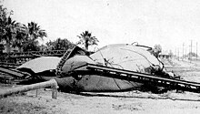
The 1952 Kern County earthquake occurred on July 21 in the southern San Joaquin Valley and measured 7.3 on the moment magnitude scale. The main shock occurred at 4:52 am Pacific Daylight Time, killed 12 people, injured hundreds more and caused an estimated $60 million in property damage. A small sector of damage near Bealville corresponded to a maximum Mercalli intensity of XI (Extreme), though this intensity rating was not representative of the majority of damage. The earthquake occurred on the White Wolf Fault near the community of Wheeler Ridge and was the strongest to occur in California since the 1906 San Francisco earthquake.

<span class="mw-page-title-main">San Jacinto Fault Zone</span> Southern Californian fault zone

The San Jacinto Fault Zone (SJFZ) is a major strike-slip fault zone that runs through San Bernardino, Riverside, San Diego, and Imperial Counties in Southern California. The SJFZ is a component of the larger San Andreas transform system and is considered to be the most seismically active fault zone in the area. Together they relieve the majority of the stress between the Pacific and North American tectonic plates.

The 1984 Morgan Hill earthquake occurred on April 24 at 1:15 p.m. local time in the Santa Clara Valley of Northern California. The shock had a moment magnitude of 6.2 and a maximum Mercalli intensity of VIII (Severe). The epicenter was located near Mount Hamilton in the Diablo Range of the California Coast Ranges. Nearby communities sustained serious damage with financial losses of at least US$7.5 million.

The 1986 Chalfant Valley earthquake struck southern Mono County near Bishop and Chalfant, California at 07:42:28 Pacific Daylight Time on July 21. With a moment magnitude of 6.2 and a maximum Mercalli intensity of VI (Strong), the shock injured two people and caused property damage estimated at $2.7 million in the affected areas. There was a significant foreshock and aftershock sequence that included a few moderate events, and was the last in a series of three earthquakes that affected southern California and the northern Owens Valley in July 1986.

<span class="mw-page-title-main">2010 Baja California earthquake</span> Earthquake in Mexico

The 2010 Baja California earthquake occurred on April 4 with a moment magnitude of 7.2 and a maximum Mercalli intensity of VII. The shock originated at 15:40:41 local time south of Guadalupe Victoria, Baja California, Mexico.

<span class="mw-page-title-main">Imperial Fault Zone</span>

The Imperial Fault Zone is a system of geological faults located in Imperial County in the Southern California region, and adjacent Baja California state in Mexico. It cuts across the border between the United States and Mexico.

The Brawley Seismic Zone (BSZ), also known as the Brawley fault zone, is a predominantly extensional tectonic zone that connects the southern terminus of the San Andreas Fault with the Imperial Fault in Southern California. The BSZ is named for the nearby town of Brawley in Imperial County, California, and the seismicity there is characterized by earthquake swarms.

The 1948 Desert Hot Springs earthquake occurred on December 4 at 3:43 p.m. Pacific Standard Time with a moment magnitude of 6.4 and a maximum Mercalli intensity of VII. The shock was felt from the central coast of California in the north, and to Baja California in the south, and came at a time when earthquake research in southern California resumed following the Second World War. It was one of two events in the 20th century that have occurred near a complex region of the southern San Andreas Fault system where it traverses the San Gorgonio Pass and the northern Coachella Valley. Damage was not severe, but some serious injuries occurred, and aftershocks continued until 1957.

The 1892 Laguna Salada earthquake occurred at 23:20 Pacific Standard Time on February 23. It had an estimated moment magnitude of 7.1–7.2 and a maximum perceived intensity of VIII (Severe). The shock was centered near the Mexico–United States border and takes its name from a large dry lake bed in Baja California, Mexico. There were no reported casualties, but the event affected the then largely-uninhabited areas of northern Mexico and Southern California.

The 1979 Imperial Valley earthquake occurred at 16:16 Pacific Daylight Time on 15 October just south of the Mexico–United States border. It affected Imperial Valley in Southern California and Mexicali Valley in northern Baja California. The earthquake had a relatively shallow hypocenter and caused property damage in the United States estimated at US$30 million. The irrigation systems in the Imperial Valley were badly affected, but no deaths occurred. It was the largest earthquake to occur in the contiguous United States since the 1971 San Fernando earthquake eight years earlier.

The 1979 Coyote Lake earthquake occurred at 10:05:24 local time on August 6 with a moment magnitude of 5.7 and a maximum Mercalli Intensity of VII. The shock occurred on the Calaveras Fault near Coyote Lake in Santa Clara County, California and resulted in a number of injuries, including some that required hospitalization. Most of the $500,000 in damage that was caused was non-structural, but several businesses were closed for repairs. Data from numerous strong motion instruments was used to determine the type, depth, and extent of slip. A non-destructive aftershock sequence that lasted throughout the remainder of the month was of interest to seismologists, especially with regard to fault creep, and following the event local governments evaluated their response to the incident.

<span class="mw-page-title-main">1918 San Jacinto earthquake</span> Earthquake in Southern California

The 1918 San Jacinto earthquake occurred in extreme eastern San Diego County in Southern California on April 21 at 14:32:29 local time. The shock had a moment magnitude of 6.7 and a maximum Mercalli intensity of IX (Violent). Several injuries and one death occurred with total losses estimated to be $200,000.

The 1838 San Andreas earthquake is believed to be a rupture along the northern part of the San Andreas Fault in June 1838. It affected approximately 100 km of the fault, from the San Francisco Peninsula to the Santa Cruz Mountains. It was a strong earthquake, with an estimated moment magnitude of 6.8 to 7.2, making it one of the largest known earthquakes in California. The region was lightly populated at the time, although structural damage was reported in San Francisco, Oakland, and Monterey. It is unknown whether there were fatalities. Based on geological sampling, the fault created approximately 1.5 meters of slip.

The 1981 Westmorland earthquake occurred at 05:09 Pacific Daylight Time on April 26. The moderate strike-slip shock took place in the Imperial Valley of Southern California, just north of the Mexico–United States border. No injuries or deaths occurred, but damage was estimated at $1–3 million. With a Mercalli intensity of VII, this was one of fifteen intensity VII or greater shocks in the Imperial Valley that were observed in the 20th century up until April 1981. The region experiences large stand-alone events and earthquake swarms due to its position in an area of complex conditions where faulting transitions from strike-slip movement to the north and divergence to the south.

The 1987 Superstition Hills and Elmore Ranch earthquakes were a pair of earthquakes measuring Mw  6.0 and 6.5 that rattled the Imperial Valley of California. The earthquakes caused damage in Southern California and Mexico, but was limited due to their location in a sparsely populated area. It was felt as far as Las Vegas and Phoenix. More than 90 were injured, and two people were killed in Mexico.

In 1954, the state of Nevada was struck by a series of earthquakes that began with three magnitude 6.0+ events in July and August that preceded the Mw  7.1–7.3 mainshock and M 6.9 aftershock, both on December 12. All five earthquakes are among the largest in the state, and the largest since the Cedar Mountain earthquake of 1932 and Pleasant Valley event in 1915. The earthquake was felt throughout much of the western United States.

The 1968 Borrego Mountain earthquake occurred on April 8, at 18:28 PST in the geologically active Salton Trough of Southern California. The Salton Trough represents a pull-apart basin formed by movements along major faults. This region is dominated by major strike-slip faults one of them being the San Jacinto Fault which produced the 1968 earthquake. The mainshock's epicenter was near the unincorporated community of Ocotillo Wells in San Diego County. The moment magnitude (Mw ) 6.6 strike-slip earthquake struck with a focal depth of 11.1 km (6.9 mi). The zone of surface rupture was assigned a maximum Modified Mercalli intensity (MMI) of VII.

The 1899 San Jacinto earthquake occurred on Christmas morning at 04:25 local time in Southern California. The estimated moment magnitude 6.7 earthquake had an epicenter located 10 miles southeast of San Jacinto. The earthquake had a maximum Mercalli intensity of IX (Violent). Severe damage occurred, amounting to US$50,000, as well as six fatalities.

The 1915 Imperial Valley earthquakes were two destructive shocks centered near El Centro, California on June 22. The earthquakes measured Ms 6.25 and occurred nearly one hour apart at 19:59 and 20:57 PST. Both shocks were assigned VIII (Severe) on the Modified Mercalli intensity scale. Heavy damage occurred in the areas of Mexicali and El Centro, amounting to $900,000. At least six people were killed in the earthquakes.

References

  1. 1 2 3 4 Stover & Coffman 1993, p. 81
  2. 1 2 3 Stover & Coffman 1993 , pp. 135–136
  3. 1 2 3 4 5 6 "Imperial Valley Earthquake". Southern California Earthquake Data Center. Archived from the original on March 2, 2012. Retrieved July 30, 2010.
  4. 1 2 Hough, S.E. (2004). Finding fault in California: an earthquake tourist's guide. Mountain Press Publishing. p. 185. ISBN   978-0-87842-495-5.
  5. 1 2 Trifunac & Brune 1970 , p. 138
  6. Mueller, K.J.; Rockwell T.K. (1995). "Late quaternary activity of the Laguna Salada fault in northern Baja California, Mexico". Geological Society of America Bulletin. 107 (1): 8–18. Bibcode:1995GSAB..107....8M. doi:10.1130/0016-7606(1995)107<0008:LQAOTL>2.3.CO;2.
  7. Elizabeth Varin (April 2, 2011). "Historic Imperial County earthquakes". Imperial Valley Press . Archived from the original on March 2, 2012. Retrieved January 20, 2012.
  8. 1 2 "Historic World Earthquakes". U.S. Geological Survey Earthquake Hazards Program. Archived from the original on November 8, 2010. Retrieved July 30, 2010.
  9. "Shock Lighter Than in 1933; Scientist Lays Temblor to Earth Movement Along San Jacinto Fault", Los Angeles Times , May 20, 1940
  10. Sharp, R.V.; Lienkaemper, J.J.; Bonilla, M.G.; Burke D.B.; Fox B.F.; Herd D.G.; Miller D.M.; Morton D.M.; Ponti D.J.; Rymer M.J.; Tinsley J.C.; Yount J.C.; Kahle J.E.; Hart E.W. & Sieh K. (1982). "Surface faulting in the central Imperial Valley". The Imperial Valley, California, Earthquake of October 15, 1979. Geological Survey professional paper. Vol. 1254. United States Government Printing Office. p. 120. Retrieved December 6, 2013.
  11. Trifunac & Brune 1970 , p. 139
  12. "Quake Razes Imperial; Three Killed; Brawley and El Centro Damaged by Temblor; All Southland Jarred", Los Angeles Times , May 19, 1940
  13. 1 2 "Quake Zone Acts to Solve Water Crisis; Imperial Valley Rationed as Crews Start Repairs on Nine Canal Breaks", Los Angeles Times , May 21, 1940
  14. Coffman, Jerry L.; von Hake, Carl A.; Stover, Carl W. (1970). Jerry L. Coffman; Carl A. von Hake (eds.). Earthquake History of the United States – Publication 41-1. United States Department of Commerce / United States Department of the Interior. p. 153.
  15. 1 2 Gunn, A.M. (2007). "Imperial Valley, California. earthquake". Encyclopedia of Disasters: Environmental Catastrophes and Human Tragedies, Volume 1. Greenwood Publishing Group. pp. 364–365. ISBN   978-0-313-34002-4.
  16. "Seismology and Earthquake Engineering" . Retrieved July 30, 2010.
  17. Trifunac & Brune 1970 , p. 137
  18. Trifunac & Brune 1970 , pp. 143, 153
  19. Sieh, K. (1996). "The repetition of large-earthquake ruptures". Proceedings of the National Academy of Sciences. 93 (9): 3764–3771. Bibcode:1996PNAS...93.3764S. doi: 10.1073/pnas.93.9.3764 . PMC   39434 . PMID   11607662.

Sources