At 20:55 PET on 25 September 2005, an earthquake measuring Mw 7.5 or ML 7.0 struck the Department of Loreto in Peru, resulting in 20 fatalities and 266 injuries, with 1,316 homes damaged or destroyed, mostly in the town of Lamas. It had a maximum perceived intensity of VI (Strong) on the Modified Mercalli Intensity Scale.

On 13 January 2001, at 11:33 CTZ, a Mw 7.7 earthquake struck off the coast of Usulután Department, El Salvador, at a depth of 60 km (37 mi). At least 952 people were killed; 944 in El Salvador and 8 in Guatemala, over 5,500 were injured and nearly 200 were left missing due to the earthquake; every single department in the country reported casualties and severe damage, and damage from the earthquake was reported in five countries throughout Central America.

On 4 June 2000, at 23:28 WIB, southern Sumatra in Indonesia was struck by an earthquake of 7.9 with a maximum Mercalli intensity of VI (Strong). The event occurred off the coast near Enggano Island. There were more than 100 fatalities and up to 2,585 injuries. Over 340 aftershocks shook the area throughout the rest of 2000, one just eleven minutes after the mainshock.
Three powerful earthquakes struck the islands of New Britain and New Ireland, Papua New Guinea on 16-17 November 2000, starting with a Mw 8.0–8.2 strike-slip event that occurred on November 16 at 04:54:56 UTC. A Mw 7.3–7.8 thrust earthquake followed at 07:42:16 UTC with its epicenter 170 km (110 mi) southeast of the first event at the southern end of its rupture zone south of New Ireland. Another Mw 7.3–7.8 thrust event occurred on November 17 at 21:01:56 UTC, occurring 174 km (108 mi) southwest of the first event with an inland epicenter at Pomio District, East New Britain Province.
The 2010 Oaxaca earthquake struck Oaxaca, Mexico on June 30, 2010, with an magnitude of 6.3. Many people in different cities left their beds and ran into the street, as the quake struck at 2:22 am.
The 1931 Oaxaca earthquake affected portions of southern Mexico on January 14 at 18:50 MST. It registered a magnitude of 8.0 on the surface-wave magnitude scale and had a maximum perceived intensity of X (Extreme) on the Mercalli intensity scale.
The 2012 Guerrero–Oaxaca earthquake struck southern Mexico with a moment magnitude of 7.4 at on Tuesday, 20 March. Its epicenter was near Ometepec, in the border between the states of Guerrero and Oaxaca. With a shallow focus of 20 km, the earthquake caused strong shaking over a large area along the Oaxaca–Guerrero border and the adjacent Pacific coastline. Significant tremors were felt in areas up to several hundred kilometers away, including Mexico City and also in Guatemala. Two people were killed and over 30,000 houses were damaged or destroyed.
The 2012 East Azerbaijan earthquakes – also known as the Ahar earthquakes – occurred on 11 August 2012, at 16:53 Iran Standard Time, near the cities of Ahar and Varzaqan in Iran's East Azerbaijan province, approximately 60 kilometers from Tabriz. They comprised a doublet separated by eleven minutes, with magnitudes of 6.4 and 6.2 . At least 306 people died and more than 3,000 others were injured, primarily in the rural and mountainous areas to the northeast of Tabriz. The shocks were felt in Armenia and the Republic of Azerbaijan, though no major damage was reported.
The 2013 Balochistan earthquakes were the deadliest to affect Pakistan since 2005. The mainshock, occurring on 24 September, had a moment magnitude of 7.8 and maximum Mercalli intensity of IX (Violent). It had an epicenter located in Awaran District, 113 km (70 mi) northwest of Bela. The mainshock killed over 820 people, injured hundreds of others, and left 100,000 people homeless. The Awaran District was among the worst affected with 80 percent of its housing stock damaged or destroyed. On 28 September, the region was affected by a Mw 6.8 aftershock, killing an additional 15 people. Rescue and recovery efforts were severely hampered by insurgents who attacked military troops sent to distribute aid. These attacks also prompted the Pakistan government to close its doors to international aid.
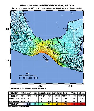
The 2017 Chiapas earthquake struck at 23:49 CDT on 7 September in the Gulf of Tehuantepec off the southern coast of Mexico near the state of Chiapas, approximately 87 kilometres (54 mi) southwest of Pijijiapan, with a Mercalli intensity of IX (Violent). The moment magnitude was estimated to be 8.2.

The 2017 Puebla earthquake, also known as 19S, struck at 13:14 CDT on 19 September 2017 with an estimated magnitude of 7.1 and strong shaking for about 20 seconds. Its epicenter was about 55 km (34 mi) south of the city of Puebla, Mexico. The earthquake caused damage in the Mexican states of Puebla and Morelos and in the Greater Mexico City area, including the collapse of more than 40 buildings. 370 people were killed by the earthquake and related building collapses, including 228 in Mexico City, and more than 6,000 were injured.

An earthquake struck Peru at 04:18:45 PET on 14 January 2018. It had a magnitude of 7.1 with a maximum perceived intensity of VII on the Mercalli intensity scale. Two deaths have been reported, with a further 139 people injured. Widespread damage to adobe houses was reported with 443 homes being destroyed. An initial tsunami warning was later rescinded.
On 4 May 2000 at 12:21 WITA, a 7.5 earthquake struck off the coast of Banggai Islands Regency, Central Sulawesi, Indonesia, which was followed by a damaging local tsunami. The earthquake and tsunami killed at least 54 people and injured 270 others, with most of the damage and casualties occurring in the Banggai Islands.
The 2019 Cotabato earthquakes were an earthquake swarm which struck the province of Cotabato on the island of Mindanao in the Philippines in October 2019. Three of these earthquakes were above 6.0 on the moment magnitude scale with a Mercalli intensity of VIII. More than 40 people have been reported dead or missing and nearly 800 were injured as a result of these events.
An earthquake struck the Mexican state of Oaxaca at 10:29 local time on June 23, 2020, with a magnitude of 7.4 . The epicenter was 19 miles (31 km) from San Miguel del Puerto and 7.5 miles (12.1 km) south-southwest of Santa María Zapotitlán. The quake was felt by an estimated 49 million people in Mexico and Guatemala, with some tremors felt as far away as 640 kilometers (400 mi). Thousands of houses in Oaxaca were damaged and 10 deaths were reported. A tsunami warning was issued for southern Mexico, El Salvador, Guatemala, and Honduras.

The 2017 Guatemala earthquake struck near the city of Malacatán in the San Marcos Department, near the Guatemala–Mexico border at 1:29 am local time (UTC−06:00) on June 14. The earthquake killed five people, and caused 30 injuries, 11 of which were from Chiapas, Mexico across the border. No tsunami warning was issued.
The 2016 Alboran Sea earthquake struck offshore, north northeast of Al Hoceïma, Morocco in the Strait of Gibraltar on 25 January at 04:22:02 UTC, or roughly 05:22:02 West Africa Time. At its strongest in the Alboran Sea, the earthquake measured 6.3–6.4 on the moment magnitude scale (Mw ) at a shallow hypocenter depth of 12 km (7.5 mi). Assigned a maximum Modified Mercalli scale intensity of VI (Strong), the earthquake caused one fatality, injuries to at least 30 persons, and moderate damage in Morocco and Spain.
A moment magnitude Mw 7.0 or 7.1 earthquake occurred near the city of Acapulco in the Mexican state of Guerrero at on 7 September with an estimated intensity of VIII (Severe) on the MMI scale. The earthquake killed 13 people and injured at least 23 others. At least 1.6 million people in Mexico were affected by the earthquake which resulted in localized severe damage. The earthquake occurred on the anniversary of the 2017 Chiapas earthquake which measured Mw 8.2. It was also the largest earthquake in Mexico since the 2020 Oaxaca earthquake.
The 2003 Dayao earthquake occurred on July 21, at 23:16:33 CST. The epicenter of the moment magnitude 5.9 earthquake was in Dayao County in the mountainous area of central Yunnan, China. At least 19 people were killed, 644 were injured, and 8,406 families became homeless. The quake also caused $75 million USD in damage.


