At 20:55 PET on 25 September 2005, an earthquake measuring Mw 7.5 or ML 7.0 struck the Department of Loreto in Peru, resulting in 20 fatalities and 266 injuries, with 1,316 homes damaged or destroyed, mostly in the town of Lamas. It had a maximum perceived intensity of VI (Strong) on the Modified Mercalli Intensity Scale.

On 13 January 2001, at 11:33 CTZ, a Mw 7.7 earthquake struck off the coast of Usulután Department, El Salvador, at a depth of 60 km (37 mi). At least 952 people were killed; 944 in El Salvador and 8 in Guatemala, over 5,500 were injured and nearly 200 were left missing due to the earthquake; every single department in the country reported casualties and severe damage, and damage from the earthquake was reported in five countries throughout Central America.

In the early morning hours of August 16, 1931, a powerful earthquake occurred in West Texas with a maximum Mercalli intensity of VIII (Severe). Estimates of its magnitude range between 5.8 and 6.4 mb, making it the most powerful earthquake ever recorded in Texas history. Its epicenter was near the town of Valentine, Texas; there, the earthquake caused damage to many homes and buildings. The earthquake may have been caused by movement along oblique-slip faulting in West Texas, the most seismically active region in the state. Shaking from the earthquake was perceptible within a 400 mi (640 km) radius of the epicenter, affecting four U.S. states and northern Mexico. Several foreshocks and aftershocks accompanied the primary temblor, with the aftershocks continuing until at least November 3, 1931. The main earthquake caused no fatalities, though several people sustained minor injuries; the damage in Valentine amounted to $50,000–$75,000.
The 1999 Oaxaca earthquake occurred on September 30 at 11:31 local time in Oaxaca, Mexico, 60 km NNW of Puerto Ángel. The epicenter was located near San Agustin Loxicha. It had a magnitude of 7.4.
The 1932 Jalisco earthquakes began on June 3 at 10:36 UTC with a megathrust event that registered 8.1 on the moment magnitude scale. With a maximum perceived intensity of X (Extreme) on the Mercalli intensity scale, at least 400 deaths were caused in Mexico and neighboring Guatemala. It was the first of a series of seismic events that affected parts of western Mexico during the month of June 1932, all reaching magnitude 7 or greater.
The 2012 Guerrero–Oaxaca earthquake struck southern Mexico with a moment magnitude of 7.4 at on Tuesday, 20 March. Its epicenter was near Ometepec, in the border between the states of Guerrero and Oaxaca. With a shallow focus of 20 km, the earthquake caused strong shaking over a large area along the Oaxaca–Guerrero border and the adjacent Pacific coastline. Significant tremors were felt in areas up to several hundred kilometers away, including Mexico City and also in Guatemala. Two people were killed and over 30,000 houses were damaged or destroyed.
The 1906 Aleutian Islands earthquake occurred at 00:11 UTC on August 17. It had an estimated seismic moment of 3.8 x 1028 dyn cm−1, equivalent to a magnitude of 8.35 on the moment magnitude scale. This earthquake was followed thirty minutes later by the 1906 Valparaíso earthquake in Chile, but the two events are not thought to be linked. Due to the remote location, there are no reports of damage associated with this earthquake. A transpacific tsunami reported from Japan and Hawaii was triggered by the Chilean event, rather than the Aleutian Islands earthquake.
The 1981 Playa Azul earthquake occurred on October 24, 1981, at 21:22 local time. It was located near Playa Azul, Michoacán, Mexico. The magnitude of the earthquake was 7.2, or 7.3. Three deaths were reported, two from Michoacán and one from Mexico City. Some buildings were damaged in both Michoacán and Mexico City. A small tsunami was registered in Acapulco with a maximum height of 9 cm.
The 1787 New Spain earthquake, also known as the San Sixto earthquake, occurred on 28 March at 11:30 local time. It caused a large tsunami that affected the coast of the Puebla Intendancy and the Oaxaca Intendancy in Southwestern New Spain. With an estimated magnitude of 8.6 on the moment magnitude scale, it was more powerful than any instrumentally recorded Mexican earthquake.
The 1975 Bagan earthquake occurred on July 8 at 6:34 pm local time in Bagan, Myanmar. Many important stupas and temples were destroyed. The strongest intensity was felt in the towns of Nyaung-U, Pakokku, and Yesagyo, and in the Myaing townships on the confluence of the Ayeyawady River. Damage was also reported in Chauk and Natmauk townships. It had a magnitude of 7.0.
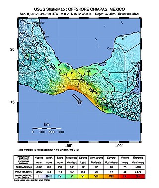
The 2017 Chiapas earthquake struck at 23:49 CDT on 7 September in the Gulf of Tehuantepec off the southern coast of Mexico near the state of Chiapas, approximately 87 kilometres (54 mi) southwest of Pijijiapan, with a Mercalli intensity of IX (Violent). The moment magnitude was estimated to be 8.2.

The 2018 Oaxaca earthquake occurred on February 16, 2018, at 17:39 local time in the Sierra Madre del Sur mountains in Oaxaca state in Southern Mexico. It had a magnitude of 7.2 on the moment magnitude scale and a maximum felt intensity of VII on the Mercalli intensity scale. The hypocenter was located at a depth of 24.6 km and approximately 37 km northeast of Pinotepa de Don Luis. There were only two reports of injuries from the earthquake, but later a military helicopter surveying the damage crashed and killed 14 people. There were also 15 people injured.
The 1982 Ometepec earthquake that struck Mexico's southwestern coast near Ometepec (Guerrero) on 7 June was a doublet earthquake that ruptured in two steps. The first happened at 06:52 UTC, the second five hours later at 10:59 UTC. Estimated magnitudes are 6.9 and 7.0 on the scale, and 5.8 and 6.0 on the scale. The maximum Mercalli intensities were VII and VIII, respectively.

On November 29, 1978, a moment magnitude 7.7–7.8 earthquake struck off the coast of the southern Mexican state Oaxaca. The thrust-faulting event caused severe damage in Oaxaca and Mexico City.
On January 30, 1973, at 15:01 (UTC–6), a magnitude 7.6 earthquake struck 35.3 km (21.9 mi) beneath the Sierra Madre del Sur range in the Mexican states of Colima, Jalisco and Michoacán. On the Mercalli intensity scale, the earthquake reached a maximum intensity of X (Extreme), causing serious damage in the region. At least 56 people were killed and about 390 were injured. The event is commonly referred to as the Colima earthquake.

A moment magnitude 6.3–6.4 earthquake affected southeastern Mexico, in the states of Puebla and Veracruz, on 3 January 1920 at 22:25 local time. A maximum Mercalli-Cancani intensity of XI–XII (Extreme) was recorded in the epicenter, between Chilchotla and Patlanalán. While estimates of the death toll vary across different sources, ranging from 648 to 4,000 fatalities, it is the second deadliest earthquake in Mexico, behind another earthquake in 1985 that killed more than 9,000 people. Many people died from mudslides that swept through settlements along the Huitzilapa and Pescado rivers. The cost of damage was estimated at US$25,000,000. The towns of Patlanalá, Barranca Grande, Cosautlán, Quimixtlán, Teocelo and Xalapa were severely affected, as many buildings were damaged or destroyed.
The 1979 Petatlán earthquake, also known as the IBERO earthquake occurred on March 14 at 05:07 local time in the Mexican state of Guerrero. The earthquake had a surface-wave magnitude of Ms 7.6 or moment magnitude of Mw 7.4 and maximum Modified Mercalli intensity of VIII (Severe). The epicenter, onshore, was located 12 km south southeast of Vallecitos de Zaragoza.
The 1983 Hindu Kush earthquake occurred south of Fayzabad, Badakhshan in northeast Afghanistan at 03:52 PST on December 31, 1983, near the border with Pakistan and the USSR. Striking 214.5 km beneath the Hindu Kush mountains, the moment magnitude 7.4 quake affected three countries, killing at least 26 people and injuring several hundred.
The 1950 Calama earthquake occurred near the Argentina–Chile border with an epicenter near Calama, Chile in the Atacama Desert on December 9. The event had a hypocenter depth of 113.9 km, beneath the Caichinque volcanic complex. It measured magnitude Mw 8.2 on the moment magnitude scale, making it the largest intermediate depth earthquake ever recorded on Chilean soil. One person was killed and an unspecified number of people were injured in Calama.
The 2022 Guatemala earthquake occurred on the early morning of February 16, 2022 in the southern regions of Guatemala. The quake measured a moment magnitude of 6.2 and reached a peak intensity of VI (Strong) on the Modified Mercalli Intensity scale. Damage was widespread but light in and around the capital, Guatemala City, resulting mostly in cracked walls and rockslides.
