 | |
| UTC time | 1935-12-28 02:35:31 |
|---|---|
| ISC event | 904721 |
| USGS-ANSS | ComCat |
| Local date | December 28, 1935 |
| Local time | 09:35 |
| Magnitude | 7.7 Mw |
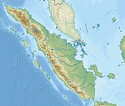
| Epicenter | 0°00′N98°15′E / 0.0°N 98.25°E [1] |
| Fault | Sunda megathrust |
| Areas affected | Sumatra, Dutch East Indies |
| Max. intensity | EMS-98 VII (Damaging) [2] |
| Tsunami | Minor |
The 1935 Sumatra earthquake occurred at 09:35 local time on 28 December. It had a magnitude of Mw 7.7 and a maximum felt intensity of VII (Damaging) on the European macroseismic scale. It triggered a minor tsunami.