Related Research Articles
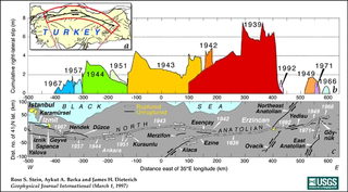
The North Anatolian Fault (NAF) is an active right-lateral strike-slip fault in northern Anatolia, and is the transform boundary between the Eurasian Plate and the Anatolian Plate. The fault extends westward from a junction with the East Anatolian Fault at the Karliova Triple Junction in eastern Turkey, across northern Turkey and into the Aegean Sea for a length of 1200−1500 kilometers. It runs about 20 km south of Istanbul. The North Anatolian Fault is similar in many ways to the San Andreas Fault in California. Both are continental transforms with similar lengths and slip rates. The Sea of Marmara near Istanbul is an extensional basin similar to the Salton Trough in California, where a releasing bend in the strike slip system creates a pull-apart basin.

The Sunda Plate is a minor tectonic plate straddling the Equator in the Eastern Hemisphere on which the majority of Southeast Asia is located.

The Hope Fault is an active dextral strike-slip fault in the northeastern part of South Island, New Zealand. It forms part of the Marlborough Fault System, which accommodates the transfer of displacement along the oblique convergent boundary between the Indo-Australian Plate and Pacific Plate, from the transform Alpine Fault to the Hikurangi Trench subduction zone.

This is a brief summary of the geology of Indonesia. Indonesia is located between two major tectonic plates, the Australian Plate and the newly-separated Sunda Plate.
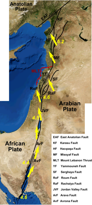
The Dead Sea Transform (DST) fault system, also sometimes referred to as the Dead Sea Rift, is a series of faults that run for about 1,000 km from the Maras Triple Junction to the northern end of the Red Sea Rift. The fault system forms the transform boundary between the African Plate to the west and the Arabian Plate to the east. It is a zone of left lateral (sinistral) displacement, signifying the relative motions of the two plates. Both plates are moving in a general north-northeast direction, but the Arabian Plate is moving faster, resulting in the observed left lateral motions along the fault of approximately 107 km at its southern end. A component of extension is also present in the southern part of the transform, which has contributed to a series of depressions, or pull-apart basins, forming the Gulf of Aqaba, Dead Sea, Sea of Galilee, and Hula basins. A component of shortening affects the Lebanon restraining bend, leading to uplift on both sides of the Beqaa valley. There is local transtension in the northernmost part of the fault system, forming the Ghab pull-apart basin. The fault system runs roughly along the political border of Israel, Jordan, and Lebanon.

The East Anatolian Fault is a ~700 km long major strike-slip fault zone running from eastern to south-central Turkey. It forms the transform type tectonic boundary between the Anatolian Plate and the northward-moving Arabian Plate. The difference in the relative motions of the two plates is manifest in the left lateral motion along the fault. The East and North Anatolian faults together accommodate the westward motion of the Anatolian Plate as it is squeezed out by the ongoing collision with the Eurasian Plate.
The Queen Charlotte Triple Junction is a geologic triple junction where three tectonic plates meet: the Pacific Plate, the North American Plate, and the Explorer Plate. The three plate boundaries which intersect here are the Queen Charlotte Fault, the northern Cascadia subduction zone, and the Explorer Ridge. The Queen Charlotte triple junction is currently positioned adjacent to the Queen Charlotte Sound near the Dellwood Knolls off the coast of Vancouver Island. 10 Ma to 1.5 Ma prior to the triple junction's current location, it was located southwest of Vancouver Island The movements of the triple junction have been characterized by two major shifts in the Pacific-North American Tertiary plate tectonic record. First, at approximately 40 Ma the relative plate motions switched from orthogonal convergence to right-lateral strike slip. The variance in location of the triple junction may have also been related to the formation of an independent basin block. This formation could have been produced by fore-arc bending of the Pacific Plate, due to oblique underthrusting prior to 1 Ma which produced stresses sufficient to break the Pacific Plate and isolate the block. Transpression of 15–30 mm/yr since 5 Ma has been taking place, as well as varying amounts of both transpression and transtension occurring before then. To the northwest of the triple junction the Pacific plate currently has 15 degrees of oblique convergence, passing under the North American plate along the Queen Charlotte transform fault zone. The Explorer plate is a small chunk of the Juan de Fuca plate that broke away from the Juan de Fuca Plate about 3.5 Ma and has moved much slower with respect to North America.

Nankai megathrust earthquakes are great megathrust earthquakes that occur along the Nankai megathrust – the fault under the Nankai Trough – which forms the plate interface between the subducting Philippine Sea Plate and the overriding Amurian Plate, which dips beneath southwestern Honshu, Japan. The fault is divided into five segments in three zones, which rupture separately or in combination, and depending on location, the resulting earthquakes are subdivided by zone from west to east into Nankai earthquakes, Tōnankai earthquakes, and Tōkai earthquakes.

The San Jacinto Fault Zone (SJFZ) is a major strike-slip fault zone that runs through San Bernardino, Riverside, San Diego, and Imperial Counties in Southern California. The SJFZ is a component of the larger San Andreas transform system and is considered to be the most seismically active fault zone in the area. Together they relieve the majority of the stress between the Pacific and North American tectonic plates.

Located in the western Pacific Ocean near Indonesia, the Molucca Sea Plate has been classified by scientists as a fully subducted microplate that is part of the Molucca Sea Collision Complex. The Molucca Sea Plate represents the only known example of divergent double subduction (DDS), which describes the subduction on both sides of a single oceanic plate.
The Clarence Fault is an active dextral strike-slip fault in the northeastern part of South Island, New Zealand. It forms part of the Marlborough Fault System, which accommodates the transfer of displacement along the oblique convergent boundary between the Indo-Australian Plate and Pacific Plate, from the transform Alpine Fault to the Hikurangi Trench subduction zone.
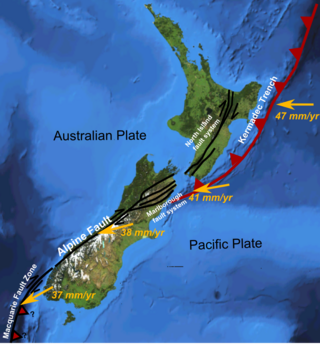
The North Island Fault System (NIFS) is a set of southwest–northeast trending seismically-active faults in the North Island of New Zealand that carry much of the dextral strike-slip component of the oblique convergence of the Pacific Plate with the Australian Plate. However despite at least 3 km (1.9 mi) of uplift of the axial ranges in the middle regions of the fault system during the last 10 million years most of the shortening on this part of the Hikurangi Margin is accommodated by subduction.
The 1968 Sulawesi earthquake struck Indonesia on August 14. It had a Richter magnitude of 7.4, spawned a large tsunami, and killed roughly 200 people.

The subduction tectonics of the Philippines is the control of geology over the Philippine archipelago. The Philippine region is seismically active and has been progressively constructed by plates converging towards each other in multiple directions. The region is also known as the Philippine Mobile Belt due to its complex tectonic setting.
On January 1, 1996, at 4:05 p.m. Central Indonesia Time, an earthquake with an epicenter in the Makassar Strait struck north of Minahasa on the island of Sulawesi, Indonesia. The earthquake measured 7.9 on the moment magnitude scale and was centered off Tolitoli Regency in Central Sulawesi, or 25 km from the Tonggolobibi village. A tsunami of 2–4 m (6.6–13.1 ft) was triggered by this earthquake as a result. At least 350 buildings were badly damaged, nine people died and 63 people were injured.
The western coast of West Sulawesi was struck by a major earthquake on 23 February 1969 at 00:36 UTC. It had a magnitude of 7.0 Mw and a maximum felt intensity of VIII on the Modified Mercalli intensity scale. It triggered a major tsunami that caused significant damage along the coast of the Makassar Strait. At least 64 people were killed, with possibly a further 600 deaths caused by the tsunami.

The Chile Ridge, also known as the Chile Rise, is a submarine oceanic ridge formed by the divergent plate boundary between the Nazca Plate and the Antarctic Plate. It extends from the triple junction of the Nazca, Pacific, and Antarctic plates to the Southern coast of Chile. The Chile Ridge is easy to recognize on the map, as the ridge is divided into several segmented fracture zones which are perpendicular to the ridge segments, showing an orthogonal shape toward the spreading direction. The total length of the ridge segments is about 550–600 km.

The 1626 Lingqiu earthquake had an epicentre in Lingqiu County, Shanxi Province during the Ming dynasty. The estimated surface wave magnitude (Ms ) 7.0 earthquake caused many buildings to collapse. Over 5,200 people were killed.
The 1979 Yapen earthquake occurred on September 12 at 05:17:51 UTC. It had an epicenter near the coast of Yapen Island in Irian Jaya, Indonesia. Measuring 7.5 on the moment magnitude scale and having a depth of 20 km (12 mi), it caused severe damage on the island. At least 115 were killed due to shaking and a moderate tsunami.

The Matano fault is a major active WNW-ESE trending left lateral strike-slip fault on the island of Sulawesi. It extends for about 190 km from near the southern end of the Palu-Koro Fault in the west, to Kolono Bay on the east coast of the island.
References
- 1 2 Heriyanto, Devina. "Central Sulawesi quake: what we know so far". Jakarta Post. Retrieved 29 September 2018.
- 1 2 Socquet A.; Simons W.; Vigny C.; McCaffrey R.; Subarya C.; Sarsito D.; Ambrosius B.; Spakman W. (2006). "Microblock rotations and fault coupling in SE Asia triple junction (Sulawesi, Indonesia) from GPS and earthquake slip vector data". Journal of Geophysical Research: Solid Earth. 111 (B8). Bibcode:2006JGRB..111.8409S. doi: 10.1029/2005JB003963 .
- 1 2 Bellier O.; Sébrier M.; Beaudoin T.; Villeneuve M.; Braucher R.; Bourlès D.; Siame L.; Outranto E.; Pratomo I. (2001). "High slip rate for a low seismicity along the Palu-Koro active fault in central Sulawesi (Indonesia)". Terra Nova. 13 (6): 463–470. Bibcode:2001TeNov..13..463B. doi: 10.1046/j.1365-3121.2001.00382.x .
- 1 2 Watkinson I.M.; Hall R. (2016). "Fault systems of the eastern Indonesian triple junction: evaluation of Quaternary activity and implications for seismic hazards" (PDF). In Cummins P.R.; Meilano I. (eds.). Geohazards in Indonesia: Earth Science for Disaster Risk Reduction. Geological Society, London, Special Publications. Vol. 441. pp. 71–120. doi:10.1144/SP441.8. ISBN 9781862399662. S2CID 132297395.