Negros Trench

Last updated
The Negros Trench 50-100 kilometers west of Visayas, The Sulu Trench in the southwest, Manila Trench west-northwest, and the Philippine Trench in the east PhilippineMobileBelt007.jpg
The Negros Trench 50-100 kilometers west of Visayas, The Sulu Trench in the southwest, Manila Trench west-northwest, and the Philippine Trench in the east
Philippines relief location map (Visayas).svg
Red pog.svg
1922
Red pog.svg
1925
Red pog.svg
1950
Red pog.svg
1951
Red pog.svg
2011
Red pog.svg
2014
Epicenters of large earthquakes ≥ 6.4 Mw along the Negros Trench, from 1922 [1] 1925 [2] 1948 [3] 1950 [4] 1951 [5] 1990 [6] 2011 [7] 2012 [8] 2014 [9]

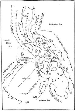
The Negros Trench is an oceanic trench located northeast of the Sulu Trench and west of Negros Island Region in Visayas, the trench is located in the Sunda Plate in the southwestern region of the Pacific Ocean. The depth of the Negros Trench is unknown, in contrast it's neighboring trench the Sulu Trench has a depth of 5,600. During the Early-Miocine, the Sunda Plate subducted below the Philippine Mobile Belt, [10] which would later form the Negros Trench.

Contents

Background

The Negros trench was formed from subduction of the Eurasian Plate underneath the Philippine Sea plate which initiated during the Early Miocene (23.03-20.44 million years ago), The trench was previously the site of a collision zone with the Palawan plate, which formed the Philippine Trench 8–9 million years ago, This trench is located west of the Visayan Islands. This trench moves 2–3 cm/year.

Although there are vast areas of subduction zones, some authors have considered this region to have low seismic activity. There has been a decent amount of earthquakes with a magnitude ≥6.4 in the region, with the most recent occurring in 2011. It hit the trench in a depth of 19.0 km. Areas adjacent to the subduction zones have experienced large seismic activity.

Seismicity

YearLocationMoment magnitudeDepthCasualties
1922west of Looc 6.515.0 km-
1925north of Nalundan 6.715.0 km17
1948 north-northeast of Buga 7.815.0 km74
1950south-southeast of San Nicolas 6.525.0 km-
1951west-northwest of Linaon 6.525.0 km1
1990 east-southeast of Union 7.118.1 km8
2011west-southwest of Cayhagan 6.419.0 km-
2012 north-northeast of Jimalalud 6.711.0 km51–113
2014west-southwest of Alim 6.315.5 km-

References

  1. "M 6.5- Luzon, Philippines". United States Geological Survey.
  2. "M 6.7 - Visayas, Philippines". United States Geological Survey.
  3. "M 7.8 -Visayas, Philippines". United States Geological Survey.
  4. "M 6.7 -Visayas, Philippines". United States Geological Survey.
  5. "M 6.5 -Visayas, Philippines". United States Geological Survey.
  6. "M 7.1 -Visayas, Philippines". United States Geological Survey.
  7. "M 6.4-Visayas, Philippines". United States Geological Survey.
  8. "M 6.7 -Visayas, Philippines". United States Geological Survey.
  9. "M 6.3-Negros, Philippines". United States Geological Survey.
  10. "Journal of Geophysical Research: Solid Earth". AGU Journals. Retrieved 2022-03-10.