1948 Lady Caycay earthquake

Last updated
1948 Lady Caycay earthquake
Philippines relief location map (square).svg
Bullseye1.png
UTC  time1948-01-24 17:46:44
ISC  event 897163
USGS-ANSS ComCat
Local date25 January 1948 (1948-01-25)
Local time01:46
Duration3 minutes
Magnitude7.8 Mw [1]
8.2 Ms [2]
Depth15 km (9 mi) [1]
Epicenter 10°48′00″N122°17′42″E / 10.8°N 122.295°E / 10.8; 122.295 [1]
Areas affected Philippines
Total damage 7,000,000
Max. intensity X (Extreme)
TsunamiYes
LandslidesYes
Casualties~ 50 (est)

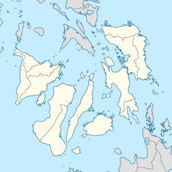
The 1948 Lady Caycay earthquake occurred at 01:46 PST (UTC+08:00) on 25 January 1948 with an estimated moment magnitude of 7.8 and a maximum Mercalli intensity of X (Extreme). The epicenter was between the municipalities of Anini-y, Antique, and Dao (present-day Tobias Fornier in Antique) on Panay Island, Philippines.

Contents

The earthquake was the second biggest on record in the country as it caused widespread damage in Panay and nearby islands. However, accounts of its intensity and the tsunamis it generated are sparse, possibly because the earthquake struck as the Philippines was recovering from the effects of the Second World War. [3]

Etymology

Caycay is a Kinaray-a and Hiligaynon term describing the scratches on the ground similar to those made by chickens. The effects of the earthquake, which chiefly manifested as fissures on the ground, were said to be similar to chicken scratches. [3] Much of Iloilo province lies on soft ground, which is one of the possible reasons for the numerous fissures that appeared, especially in low-lying parts of the province.

Effect

Philippines location map (Visayas).svg
Red pog.svg
1948
Red pog.svg
1950
Red pog.svg
1951
Along with the 1948 Lady CayCay earthquake (7.8 Mw), other relatively strong events near the area were in 1950 (6.7 Mw) [4] and 1951 (6.5 Mw). [5] See also the Negros Trench in the map below.
The Negros Trench in the western Visayas and the Philippine Mobile Belt PhilippineMobileBelt007.jpg
The Negros Trench in the western Visayas and the Philippine Mobile Belt

José María Cuenco, the Bishop of Jaro, estimated that the damage to 15 churches destroyed on Panay alone amounted to 7,000,000.

Antique province

In the town of Anini-y (the earthquake's epicentre), no distinct damage was seen in the century-old church—the only confirmed masonry structure existing at the time. [3] The church, which was originally built in 1830 had been damaged during the Second World War. In Pandan and Culasi towns, it was reported that 50% of the houses were destroyed. Massive landslides also occurred in the mountain area. [3]

Aklan province

Ibajay Bridge and Kalibo Bridge, which were the two of the biggest bridges in Panay, sustained damage. [3]

Capiz province

The Immaculate Conception Metropolitan Cathedral in Capiz (now Roxas City) was reported to have been damaged by the earthquake. [3]

Iloilo province

Most of the significant damage was found in the Iloilo province, specifically to extant Spanish-era churches. Bridges, communication lines, as well as public and private buildings all sustained heavy damage.

The churches in Igbaras, San Miguel, Oton, and Maasin were severely damaged and were demolished. [3] The belfries of churches in Alimodian, Duenas, Dumangas, Guimbal, Lambunao, Passi, San Joaquin, and Arevalo districts in Iloilo City collapsed, while Jaro Cathedral (the city's episcopal see) was also severely damaged. Twenty-one were reportedly killed in the city, and another forty-three were injured. Damage to churches was estimated at ₱200,000, with the total damage to the city reaching ₱1,000,000. [3] The Coronet Tower in Arevalo District also collapsed, as did the old Central School and back portion of the church in León. The churches of Pavia, Tubungan, Miag-ao, and Tigbauan also sustained damage. [3]

Fissures

Fissures erupted in the streets, causing traffic disruptions. Fissures were also observed along the roads between Pototan and Dingle and along the Santa Barbara railway. Fissures were also noted in the streets of Oton [3] (Bautista, M.L.P, et al., 2011).

Ground disruptions described as “little canyons”, possibly the sand blows, were observed in Pototan, Cabatuan, Dingle, Passi, and Calinog. A new, small brook appeared after huge cracks appeared at Tiring Landing Field (now the site of the Iloilo International Airport) in Cabatuan. In the city's Fort San Pedro, large fissures 4 metres wide by 10 metres long opened such that seawater was already visible. [3]

Tsunami

Local accounts have pointed to a 2-metre high wave that was seen after the earthquake. Fish corals from the Iloilo shore towns of Oton to San Joaquin were destroyed by the tsunami. Damage was estimated to be at ₱250,000. The fish corals were detached from the log moorings. The waves did not move inward thereby sparing more damage to life and property. [3]

See also

Related Research Articles

<span class="mw-page-title-main">Iloilo</span> Province in Western Visayas, Philippines

Iloilo, officially the Province of Iloilo, is a province in the Philippines located in the Western Visayas region. Its capital is the City of Iloilo, the regional center of Western Visayas. Iloilo occupies a major southeast portion of the Visayan island of Panay and is bordered by the province of Antique to the west, Capiz to the north, the Jintotolo Channel to the northeast, the Guimaras Strait to the east, and the Iloilo Strait and Panay Gulf to the southwest.

<span class="mw-page-title-main">Iloilo City</span> Capital of Iloilo, Philippines

Iloilo City, officially the City of Iloilo, is a 1st class highly urbanized city in the Western Visayas region of the Philippines on the island of Panay. It is the capital city of the province of Iloilo, where it is geographically situated and grouped under the Philippine Statistics Authority, but remains politically independent in terms of government and administration. In addition, it is the center of the Iloilo–Guimaras Metropolitan Area, as well as the regional center and primate city of the Western Visayas region. According to the 2020 census, Iloilo City has a population of 457,626 people. For the metropolitan area, the total population is 1,007,945 people.

<span class="mw-page-title-main">Dingle, Iloilo</span> Municipality in Iloilo, Philippines

Dingle, officially the Municipality of Dingle, is a 3rd class municipality in the province of Iloilo, Philippines. According to the 2020 census, it has a population of 45,965 people.

<span class="mw-page-title-main">Oton</span> Municipality in Iloilo, Philippines

Oton, officially the Municipality of Oton, is a 1st class municipality in the province of Iloilo, Philippines. According to the 2020 census, it has a population of 98,509 people making it as the most populous town in the province and the entire Panay island.

<span class="mw-page-title-main">Jaro, Iloilo City</span> District of Iloilo City, Philippines

Jaro is a district of Iloilo City in the Philippine province of Iloilo on Panay Island in the Western Visayas region. It is the largest in terms of area and population of Iloilo City's seven districts, with 130,700 people in the 2020 census. Once a separate city, Jaro merged with Iloilo City when it was re-incorporated in the 1940s during the American administration in the Philippines. Jaro is the largest of all the seven districts comprising the City of Iloilo. The Iloilo City district of La Paz and the present municipalities of Leganes and Pavia, adjoined as historical parts of Jaro before they became independent.

The legislative districts of Iloilo are the representations of the province of Iloilo in the various national legislatures of the Philippines. The province is currently represented in the lower house of the Congress of the Philippines through its first, second, third, fourth and fifth congressional districts.

<span class="mw-page-title-main">Arevalo, Iloilo City</span> District of Iloilo City, Philippines

Villa de Arevalo, commonly known as simply Villa or Arevalo, is one of the seven districts of Iloilo City in the province of Iloilo, on the island of Panay in Western Visayas, in the Philippines. According to the 2020 census, it has a population of 55,476 people. Arevalo is the westernmost district of Iloilo City and it borders Oton to the west.

<span class="mw-page-title-main">Metro Iloilo–Guimaras</span> Metropolitan area in the Philippines

Metropolitan Iloilo–Guimaras, also shortened as Metro Iloilo–Guimaras or simply MIG, is a metropolitan area in the Visayas in the Philippines. It consists of the highly urbanized city of Iloilo City; the regional agro-industrial center of Pavia; the municipalities of Cabatuan, Leganes, Oton, San Miguel, and Santa Barbara; and the neighboring island province of Guimaras, with its five municipalities of Jordan, Buenavista, Nueva Valencia, San Lorenzo, and Sibunag.

<span class="mw-page-title-main">Jalaur River</span> River in Western Visayas, Philippines

The Jalaur River, also known as Jalaud River, is the second longest river on Panay island in the Philippines, with a total length of 123 km (76 mi) and the second largest by drainage basin after Panay River in Capiz. The Jalaur has a drainage area of 1,503 square kilometres (580 sq mi). Its source is in the Central Panay Mountain Range, west of Calinog, and the river traverses east to southeast before emptying into the Guimaras Strait. It drains the eastern portion of Panay and courses through Passi City and the towns of Leganes, Zarraga, Dumangas, Barotac Nuevo, Pototan, Dingle, San Enrique, Duenas, and Calinog, all in Iloilo province.

<span class="mw-page-title-main">Jaro Cathedral</span> Seat of the Archdiocese of Jaro in the Philippines

The Metropolitan Cathedral of Saint Elizabeth of Hungary, also known as the National Shrine of Our Lady of the Candles and colloquially as Jaro Cathedral, is a cathedral located in the district of Jaro in Iloilo City, on the island of Panay in the Philippines. The seat of the Roman Catholic Archdiocese of Jaro, it was placed under the patronage of Saint Elizabeth of Hungary. It was established in 1575 as a visita (chapel-of-ease) of Oton by the Augustinians and as a separate parish in 1587. The present-day structure of Jaro Cathedral was built in 1874.

The 2012 Negros earthquake occurred on February 6 at 11:49 PST, with a body wave magnitude of 6.7 and a maximum intensity of VII (Destructive) off the coast of Negros Oriental, Philippines. The epicenter of the thrust fault earthquake was approximately 72 kilometres (45 mi) north of Negros Oriental's provincial capital, Dumaguete.

<span class="mw-page-title-main">Panay Railways</span>

Panay Railways Inc. is a government-owned and controlled corporation of the Philippines headquartered in La Paz, Iloilo City on the island of Panay. It is a subsidiary of Phividec Railways Inc. of the Philippine Veterans Investment Development Corporation (Philvedec). The railway currently doesn't operate any trains but it leases the property that it owns and the revenue is used to defray the personnel and administrative costs incurred from looking after its assets.

<span class="mw-page-title-main">San Vicente Ferrer Church (Leganes, Iloilo)</span> Church in Iloilo, Philippines

The Archdiocesan Shrine of St. Vincent Ferrer is a neoclassical church dedicated to Saint Vincent Ferrer in Leganes, Iloilo, Philippines under the Archdiocese of Jaro. Its current structure is a result of the numerous restoration efforts which was necessity because of both man-made and natural disasters.

<span class="mw-page-title-main">Karay-a language</span> Visayan language

The Karay-a language is an Austronesian regional language in the Philippines spoken by the Karay-a people, mainly in Antique.

<span class="mw-page-title-main">Passi, Iloilo</span> Component city in Iloilo, Philippines

Passi, officially the City of Passi, is a 4th class component city in the province of Iloilo, Philippines. According to the 2020 census, it has a population of 88,873 people.

On July 6, 2017, a 6.5 magnitude earthquake hit Leyte, causing at least 4 deaths and 100 injuries. The quake also caused power interruptions in the whole of Eastern Visayas and nearby Bohol.

<span class="mw-page-title-main">Governor of Iloilo</span> Local chief executive

The Governor of Iloilo is the local chief executive of the Philippine province of Iloilo. The governor holds office at the Iloilo Provincial Capitol located at Bonifacio Drive, Iloilo City. Like all local government heads in the Philippines, the governor is elected via popular vote, and may not be elected for a fourth consecutive term. In case of death, resignation or incapacity, the vice governor becomes the governor. Along with the governors of Aklan, Antique, Capiz, Guimaras and Negros Occidental, he sits in the Regional Development Council of the Western Visayas Region.

<span class="mw-page-title-main">1990 Panay earthquake</span> Earthquake in Panay Island on June 14, 1990

The 1990 Panay earthquake occurred at 3:41 p.m. local time on 14 June 1990 with a moment magnitude of 7.1 in the Richter scale, leaving eight dead and 41 others injured. The epicenter was located at Culasi, Antique on Panay Island in the Philippines. The depth was computed to be 15 kilometers. It was generated by fault movement in the collisional zone off western Panay Island.

<span class="mw-page-title-main">Jaro Belfry</span> Bell tower in Iloilo City, Philippines

Jaro Belfry, also known as Campanario de Jaro, is a historical free-standing bell tower located in front of the Jaro Metropolitan Cathedral in Jaro, Iloilo City, Philippines. It is one of the few belfries in the country that stood apart from the church where it belonged.

References

  1. 1 2 3 "M 7.8 – Panay, Philippines". United States Geological Survey. January 24, 1948. Retrieved August 27, 2017.
  2. "PRESS RELEASE: "Join the earthquake drill" urges DOST-PHIVOLCS". phivolcs.dost.gov.ph. PHIVOLCS . Retrieved February 21, 2019.
  3. 1 2 3 4 5 6 7 8 9 10 11 12 Bautista M.L.P.; Bautista B.C.; Narag I.C.; Atando R.A. & Relota E.P. (April 2011). "The 1984 (Ms 8.2) Lady Caycay Earthquake and Tsunami and Its Possible Socio-economic Impact to Western Visayan Communities in the Philippines". Proceedings of the Ninth Pacific Conference on Earthquake Engineering Auckland, New Zealand.
  4. "M 6.7 - Panay, Philippines". United States Geological Survey . Retrieved March 12, 2018.
  5. "M 6.5 - Negeros, Philippines". United States Geological Survey . Retrieved March 12, 2018.