1897 Mindanao earthquakes

Last updated

1897 Mindanao earthquakes
Philippines relief location map (square).svg
Bullseye1.png
Local dateSeptember 20, 1897 (1897-09-20), September 21, 1897 (1897-09-21)
Magnitude7.4, 7.5 Ms
Epicenter 6°00′N122°00′E / 6.0°N 122.0°E / 6.0; 122.0 Coordinates: 6°00′N122°00′E / 6.0°N 122.0°E / 6.0; 122.0
Max. intensity VII (Very strong)
IX (Violent)
TsunamiBoth
CasualtiesNone reported, 13 to 100+

The 1897 Mindanao earthquakes occurred on September 20, 1897, at 19:06 UTC and September 21, 1897, at 05:12 UTC. The estimated epicentres of the two earthquakes are identical, lying just off the southwestern coast of Mindanao in the Philippines, south of Basilan island. The earthquakes were originally given estimated magnitudes of 8.6 and 8.7 on the surface wave magnitude scale by Charles Richter, [1] [2] but these were revised downwards by Katsuyuki Abe to 7.4 and 7.5 Ms , respectively. [3] Contemporary reports noted that with few exceptions, all the masonry buildings in Zamboanga and Basilan were left in ruins. [4]

Both earthquakes triggered tsunamis, with the second being quite destructive, with a maximum run-up of 7.0 m. [5] The tsunami was noted all along the southwest coast of Negros, the west coast of Panay, the south coast of Palawan, the west coast of Mindanao, and the east coast of Borneo. [6] At least 13 died as a result of the second tsunami, with a hundred or more casualties also being reported. [2]

See also

Related Research Articles

<span class="mw-page-title-main">1703 Genroku earthquake</span> Earthquake near Edo in the Kantō region, Japan

The 1703 Genroku earthquake occurred at 02:00 local time on December 31. The epicenter was near Edo, the forerunner of present-day Tokyo, in the southern part of the Kantō region, Japan. An estimated 2,300 people were killed by the shaking and subsequent fires. The earthquake triggered a major tsunami which caused many additional casualties, giving a total death toll of at least 5,233, possibly up to 10,000. Genroku is a Japanese era spanning from 1688 through 1704.

The 1730 Valparaíso earthquake occurred at 04:45 local time on July 8. It had an estimated magnitude of 9.1–9.3 and triggered a major tsunami with an estimated magnitude of Mt  8.75, that inundated the lower parts of Valparaíso. The earthquake caused severe damage from La Serena to Chillan, while the tsunami affected more than 1,000 km (620 mi) of Chile's coastline.

<span class="mw-page-title-main">1881 Chios earthquake</span> Earthquake on the island of Chios in 1881

The 1881 Chios earthquake occurred at 13:40 local time on 3 April. It caused severe damage on the island of Chios and also affected Çeşme and Alaçatı on the coast of Turkey. The earthquake had an estimated magnitude of 7.3 and there were an estimated 7,866 casualties. The devastation from the earthquake was the last of the three 'catastrophes' that affected the island of Chios in the 19th century.

<span class="mw-page-title-main">1868 Ecuador earthquakes</span>

The 1868 Ecuador earthquakes occurred at 19:30 UTC on August 15 and 06:30 UTC on 16 August 1868. They caused severe damage in the northeastern part of Ecuador and in southwestern Colombia. They had an estimated magnitude of 6.3 and 6.7 and together caused up to 70,000 casualties. The earthquake of 15 August occurred near El Ángel, Carchi Province, close to the border with Colombia, while that of August 16 occurred near Ibarra in Imbabura Province. Reports of these earthquakes are often confused with the effects of the earthquake of 13 August at Arica.

The 1667 Shamakhi earthquake occurred on 25 November 1667 with an epicenter close to the city of Shamakhi, Azerbaijan. It had an estimated surface wave magnitude of 6.9 and a maximum felt intensity of X (Extreme) on the Mercalli intensity scale. An estimated 80,000 people died.

<span class="mw-page-title-main">1498 Meiō earthquake</span> 1498 earthquake and tsunami centered off the coast of Nankaidō, Japan

The 1498 Meiō earthquake occurred off the coast of Nankaidō, Japan, at about 08:00 local time on 20 September 1498. It had a magnitude estimated at 8.6 Ms and triggered a large tsunami. The death toll associated with this event is uncertain, but between 5,000 and 41,000 casualties were reported. The tsunami caused by the Meiō Nankaidō earthquake washed away the building housing the statue of the Great Buddha at Kōtoku-in in Kamakura, although the statue itself remained intact.

The 1293 Kamakura earthquake in Japan occurred at about 06:00 local time on 27 May 1293. It had an estimated magnitude of 7.1–7.5 and triggered a tsunami. The estimated death toll was 23,024. It occurred during the Kamakura period, and the city of Kamakura was seriously damaged.

The 1877 Iquique earthquake occurred at 21:16 local time on 9 May. It had a magnitude of 8.5 on the surface wave magnitude scale. Other estimates of its magnitude have been as high as 8.9 Mw and 9.0 Mt. It had a maximum intensity of XI (Extreme) on the Mercalli intensity scale and triggered a devastating tsunami. A total of 2,385 people died, mainly in Fiji.

The 1762 Arakan earthquake occurred at about 17:00 local time on 2 April, with an epicentre somewhere on the coast from Chittagong to Arakan in modern Burma. It had an estimated magnitude of as high as 8.8 on the moment magnitude scale and a maximum estimated intensity of XI (Extreme) on the Mercalli intensity scale. It triggered a local tsunami in the Bay of Bengal and caused at least 200 deaths. The earthquake was associated with major areas of both uplift and subsidence. It is also associated with a change in course of the Brahmaputra River to from east of Dhaka to 150 kilometres (93 mi) to the west via the Jamuna River.

The 1941 Andaman Islands earthquake struck the Andaman Islands on June 26 with a magnitude of 7.7 to 8.1. Details of this event are poorly known as much of Southeast Asia was in the turmoil of World War II. The quake caused severe damage in the Andaman Islands. The tsunami it triggered was reported along the Andaman and Nicobar Islands, India, and Sri Lanka. There may have been damage and deaths in Bangladesh, Myanmar, and Thailand due to the tsunami.

<span class="mw-page-title-main">1918 Celebes Sea earthquake</span> Earthquake in the Philippines

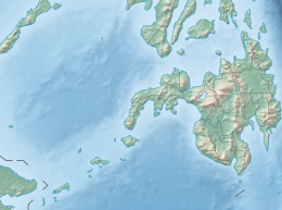
The 1918 Celebes Sea earthquake occurred on August 15 at 12:18 UTC near the Moro Gulf coast of Mindanao. It had a magnitude of 8.3 on the moment magnitude scale and a maximum perceived intensity of X (Extreme) on the Mercalli intensity scale.

The area around Constantinople was affected by a major earthquake in AD 447. It caused serious damage to the recently completed Theodosian Walls in Constantinople, destroying 57 towers and large stretches of the walls. The historical records contain no mention of casualties directly associated with this earthquake, although many thousands of people were reported to have died in the aftermath due to starvation and a "noxious smell".

The western coast of West Sulawesi was struck by a major earthquake on 23 February 1969 at 00:36 UTC. It had a magnitude of 7.0 Mw and a maximum felt intensity of VIII on the Modified Mercalli intensity scale. It triggered a major tsunami that caused significant damage along the coast of the Makassar Strait. At least 64 people were killed, with possibly a further 600 deaths caused by the tsunami.

The 1761 Lisbon earthquake and its subsequent tsunami occurred in the north Atlantic Ocean and south of the Iberian Peninsula. This violent shock which struck just after noon on 31 March 1761, was felt across many parts of Western Europe. Its direct effects were even observed far north in Scotland and Amsterdam, and to the south in the Canary Islands of Spain. The estimated surface-wave magnitude 8.5 event was the largest in the region, and the most significant earthquake in Europe since the Great Lisbon earthquake of 1755.

The 1674 Ambon earthquake occurred on February 17 between 19:30 and 20:00 local time in the Maluku Islands. The resulting tsunami reached heights of up to 100 metres (330 ft) on Ambon Island killing over 2,000 individuals. It was the first detailed documentation of a tsunami in Indonesia and the largest ever recorded in the country. The exact fault which produced the earthquake has never been determined, but geologists postulate either a local fault, or a larger thrust fault offshore. The extreme tsunami was likely the result of a submarine landslide.

During April 1819, the area around Copiapó in northern Chile was struck by a sequence of earthquakes over a period of several days. The largest of these earthquakes occurred on 11 April at about 15:00 local time, with an estimated magnitude of Mw 8.5. The other two events, on 3 April between 08:00 and 09:00 local time and on 4 April at 16:00 local time, are interpreted as foreshocks to the mainshock on 11 April. The mainshock triggered a tsunami that affected 800 km of coastline and was also recorded at Hawaii. The city of Copiapó was devastated.

The 1872 Amik (Antioch) earthquake occurred on April 3 with an epicenter the Amik Valley in the Ottoman Empire. Earthquake catalogs place the surface-wave magnitude at Ms  7.2 and MSK 64 rating at XI (Catastrophic). Turkey and Syria were devastated by this earthquake, and the region lost at least 1,800 residents.

On 29 November, at 14:10 UTC, a magnitude 7.7 Mw earthquake struck off the southern coast of Taliabu Island Regency in North Maluku, Indonesia. At least 41 people were killed on the nearby islands and a tsunami was triggered. Several hundred homes, buildings and offices were damaged or destroyed.

The 1941 Hyūga-nada earthquake occurred off the coast of Kyushu, Japan at 19:02 local time on November 19. The earthquake measured 8.0 Mw  and had a depth of 35 km (22 mi). A seismic intensity of 5 was observed in Miyazaki City and Nobeoka City in Miyazaki Prefecture, and Hitoyoshi City in Kumamoto Prefecture. Due to the earthquake, a tsunami with a maximum wave height of 1.2 m was observed in Kyushu and Shikoku. The tsunami washed away many ships. Twenty seven homes were destroyed and two people were killed. In Miyazaki, Ōita and Kagoshima prefectures, telephone services were disrupted. Subsidence by 8 cm (3.1 in) was recorded at Hyūga, Miyazaki. At Nobeoka, stone walls and embankments were damaged while roads cracked. It was felt as far as central Honshu.

References

  1. "Significant Earthquake Information (20/9)". NCEI/WDS Global Significant Earthquake Database. National Geophysical Data Center/ World Data Service (NGDC/WDS). doi:10.7289/V5TD9V7K . Retrieved August 2, 2022.
  2. 1 2 "Significant Earthquake Information (21/9)". NCEI/WDS Global Significant Earthquake Database. National Geophysical Data Center/ World Data Service (NGDC/WDS). doi:10.7289/V5TD9V7K . Retrieved August 2, 2022.
  3. Ye L., Lay T. & Kanamori H. (2012). "Intraplate and interplate faulting interactions during the August 31, 2012, Philippine Trench earthquake (M w 7.6) sequence". Geophysical Research Letters. L24310 (24): n/a. Bibcode:2012GeoRL..3924310Y. doi: 10.1029/2012GL054164 .
  4. Coronas, José (1899). La actividad séismica en el Archipiélago filipino durante el año 1897 (in Spanish). Manila Observatory: Tipolitografía del Observatorio.
  5. "Tsunami Event Information (21/9)". NGDC/WDS Global Tsunami Event Database. National Geophysical Data Center/ World Data Service. doi:10.7289/V5PN93H7 . Retrieved August 2, 2022.
  6. Saderra Masó, Miguel (1904). Volcanoes and seismic centers of the Philippine Archipelago. Census of the Philippine Islands. Vol. Bulletin 3. Bureau of the Census. pp. 42–44.