
The Lesser Antilles are a group of islands in the Caribbean Sea. Most of them are part of a long, partially volcanic island arc between the Greater Antilles to the north-west and the continent of South America. The islands of the Lesser Antilles form the eastern boundary of the Caribbean Sea where it meets the Atlantic Ocean. Together, the Lesser Antilles and the Greater Antilles make up the Antilles. The Lesser and Greater Antilles, together with the Lucayan Archipelago, are collectively known as the West Indies.

The Caribbean Plate is a mostly oceanic tectonic plate underlying Central America and the Caribbean Sea off the northern coast of South America.
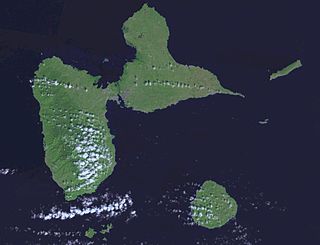
Guadeloupe is an archipelago of more than 12 islands, as well as islets and rocks situated where the northeastern Caribbean Sea meets the western Atlantic Ocean. It is located in the Leeward Islands in the northern part of the Lesser Antilles, a partly volcanic island arc. To the north lie Antigua and Barbuda and the British Overseas Territory of Montserrat, with Dominica lying to the south.
The 1938 Banda Sea earthquake occurred on February 2 with an estimated magnitude of 8.5–8.6 on the moment magnitude scale and a Rossi–Forel intensity of VII. This oblique-slip event generated destructive tsunamis of up to 1.5 metres in the Banda Sea region, but there were no deaths.
The 1303 Crete earthquake occurred at about dawn on 8 August. It had an estimated magnitude of about 8, a maximum intensity of IX (Violent) on the Mercalli intensity scale, and triggered a major tsunami that caused severe damage and loss of life on Crete and at Alexandria. It badly damaged the Lighthouse of Alexandria.
The 1881 Nicobar Islands earthquake occurred at about 07:49 local time on 31 December, with an epicentre beneath Car Nicobar. It occurred as two separate ruptures, the largest of which had an estimated magnitude of 7.9 on the moment magnitude scale and triggered a tsunami that was observed around the Bay of Bengal. It is probably the earliest earthquake for which rupture parameters have been estimated instrumentally.
The 1877 Iquique earthquake occurred at 21:16 local time on 9 May. It had a magnitude of 8.5 on the surface wave magnitude scale. Other estimates of its magnitude have been as high as 8.9 and 9.0 . It had a maximum intensity of XI (Extreme) on the Mercalli intensity scale and triggered a devastating tsunami. A total of 2,385 people died, mainly in Fiji.
The 1968 Hyūga-nada earthquake occurred on April 1 at . The earthquake had a magnitude of 7.5, and the epicenter was located in Hyūga-nada Sea, off the islands of Kyushu and Shikoku, Japan. The magnitude of this earthquake was also given as 7.5. A tsunami was observed. One person was killed, and 22 people were reported injured. The intensity reached shindo 5 in Miyazaki and Kōchi.
The 2004 Les Saintes earthquake occurred at on November 21, 2004 with a moment magnitude of 6.3 and maximum European macroseismic intensity of VIII. The shock was named for Îles des Saintes "Island of the Saints", a group of small islands to the south of Guadeloupe, which is an overseas department of France. Although it occurred near the Lesser Antilles subduction zone, this was an intraplate, normal fault event. It resulted in one death, 13 injuries, and 40 people being made homeless, but the overall damage was considered moderate. A small, nondestructive tsunami was reported, but run-up and inundation distances were difficult to measure due to a storm that occurred on the day of the event. Unusual effects at a volcanic lake on Dominica were also documented, and an aftershock caused additional damage three months later.
The 1974 Lesser Antilles earthquake occurred at on October 8 with a moment magnitude of 6.9 and a maximum Mercalli intensity of VIII (Severe). Four people were injured in what the United States' National Geophysical Data Center called a moderately destructive event.
The 1988 Myanmar–India earthquake, also known as the Indo–Burma earthquake struck the Sagaing Region of Myanmar, about 30 kilometres (19 mi) from the border with India on 6 August at 7:06 am MMT with a moment magnitude (Mw ) of 7.3 or Richter magnitude (ML ) of 7.5. At least five people were killed, more than 30 were injured, and another 30 were missing as a result. Serious damage was reported in India and Bangladesh, while some minor damage occurred in Myanmar. The earthquake was reportedly felt in the Soviet Union.

The 1867 Virgin Islands earthquake and tsunami occurred on November 18, at 14.45 in the Anegada Passage about 20 km southwest of Saint Thomas, Danish West Indies. The Ms 7.5 earthquake came just 20 days after the devastating San Narciso Hurricane in the same region. Tsunamis from this earthquake were some of the highest ever recorded in the Lesser Antilles. Wave heights exceeded 10 m (33 ft) in some islands in the Lesser Antilles. The earthquake and tsunami resulted in no more than 50 fatalities, although hundreds of casualties were reported.
The 1839 Martinique earthquake occurred on the morning of January 11 with an estimated magnitude of 7.8 Ms , the largest in the Lesser Antilles since 1690. The maximum intensity of this earthquake was assigned IX on both the Mercalli and MSK intensity scales, which left the cities of Saint-Pierre and Fort Royal almost completely destroyed. Estimation on the number of human losses varies from 390 to even 4,000 making this one of the deadliest earthquakes in the Caribbean.
The 1852 Banda Sea earthquake struck on 26 November at 07:40 local time, affecting coastal communities on the Banda Islands. It caused violent shaking lasting five minutes, and was assigned XI on the Modified Mercalli intensity scale in the Maluku Islands. A tsunami measuring up to 8 m (26 ft) slammed into the islands of Banda Neira, Saparua, Haruku and Ceram. The tsunami caused major damage, washing away many villages, ships and residents. At least 60 people were killed in the earthquake and tsunami. The earthquake had an estimated moment magnitude of 7.5 or 8.4–8.8, according to various academic studies.

An earthquake occurred off the coast of the Alaska Peninsula on July 28, 2021, at 10:15 p.m. local time. The large megathrust earthquake had a moment magnitude of 8.2 according to the United States Geological Survey (USGS). A tsunami warning was issued by the National Oceanic and Atmospheric Administration (NOAA) but later cancelled. The mainshock was followed by a number of aftershocks, including three that were of magnitude 5.9, 6.1 and 6.9 respectively.
The 1815 Bali earthquake occurred on November 22 between 22:00 and 23:00 local time (WITA), affecting the Bali Kingdom. The estimated moment magnitude 7.0 earthquake struck off the north coast of Bali at a shallow depth. It was assigned a maximum intensity of IX (Violent) on the Mercalli intensity scale, causing severe damage in Buleleng and Tabanan. The earthquake caused a landslide and tsunami that killed 11,453 people.
During April 1819, the area around Copiapó in northern Chile was struck by a sequence of earthquakes over a period of several days. The largest of these earthquakes occurred on 11 April at about 15:00 local time, with an estimated magnitude of 8.5. The other two events, on 3 April between 08:00 and 09:00 local time and on 4 April at 16:00 local time, are interpreted as foreshocks to the mainshock on 11 April. The mainshock triggered a tsunami that affected 800 km of coastline and was also recorded at Hawaii. The city of Copiapó was devastated.
The 1843 Nias earthquake off the northern coast of Sumatra, Indonesia caused severe damage when it triggered a tsunami along the coastline. The earthquake with a moment magnitude (Mw ) of 7.8 lasted nine minutes, collapsing many homes in Sumatra and Nias. It was assigned a maximum modified Mercalli intensity of XI (Extreme).
The 1933 Sumatra earthquake or Liwa earthquake occurred in West Lampung Regency, Lampung Province, Indonesia on June 25. The earthquake had an estimated surface-wave magnitude (Ms ) of 7.7 occurring at a shallow depth of 20 km. It had an epicenter onshore, devastating the city of Liwa. At least 76 people were reported killed, although the death toll may have been in the thousands. Aftershocks followed, including one which was strong enough to cause additional fatalities. The mainshock also triggered a nearby volcanic eruption two weeks later, killing some people.
The 1858 Prome earthquake occurred on August 24 at 15:38 local time in British Burma. The earthquake occurred with a magnitude of 7.6–8.3 on the moment magnitude scale. It had an epicenter in near the city of Pyay (Prome), Bago. The shock was felt with a maximum Modified Mercalli intensity of XI (Extreme) for about one minute. Severe damage was reported in Bago, and off the coast of Rakhine, an island sunk.
