Mount Ruapehu is an active stratovolcano at the southern end of the Taupō Volcanic Zone and North Island volcanic plateau in New Zealand. It is 23 km (14 mi) northeast of Ohakune and 23 km (14 mi) southwest of the southern shore of Lake Taupō, within the Tongariro National Park. The North Island's major ski resorts and only glaciers are on its slopes.

Mount Etna, or simply Etna, is an active stratovolcano on the east coast of Sicily, Italy, in the Metropolitan City of Catania, between the cities of Messina and Catania. It is located above the convergent plate margin between the African Plate and the Eurasian Plate. It is one of the tallest active volcanoes in Europe, and the tallest peak in Italy south of the Alps with a current height of 3,403 m (11,165 ft), though this varies with summit eruptions. For instance, in 2021 the southeastern crater reached a height of 3,357 m, but was then surpassed by the Voragine crater after the summer 2024 eruptions.

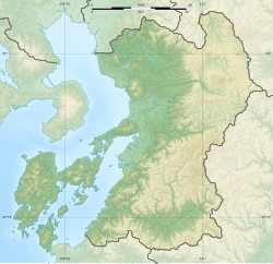
Iwate Prefecture is a prefecture of Japan located in the Tōhoku region of Honshu. It is the second-largest Japanese prefecture at 15,275 square kilometres (5,898 sq mi), with a population of 1,165,886. Iwate Prefecture borders Aomori Prefecture to the north, Akita Prefecture to the west, and Miyagi Prefecture to the south.

The Ring of Fire is a tectonic belt of volcanoes and earthquakes.

Mount Pinatubo is an active stratovolcano in the Zambales Mountains in Luzon in the Philippines. Located on the tripoint of Zambales, Tarlac and Pampanga provinces, most people were unaware of its eruptive history before the pre-eruption volcanic activity in early 1991. Dense forests, which supported a population of several thousand indigenous Aetas, heavily eroded and obscured Pinatubo.

Mount Unzen is an active volcanic group of several overlapping stratovolcanoes, near the city of Shimabara, Nagasaki on the island of Kyushu, Japan's southernmost main island.

Mount Aso or Aso Volcano is the largest active volcano in Japan and among the largest in the world. Common use relates often only to the somma volcano in the centre of Aso Caldera. It stands in Aso Kujū National Park in Kumamoto Prefecture, on the island of Kyushu. Its tallest peak, Takadake, is 1,592 meters (5,223 ft) above sea level. Mount Aso is in a fairly large caldera with a circumference of around 120 km (75 mi), although sources vary on the exact distance. It is one of the 100 Famous Japanese Mountains.

Sakurajima is an active stratovolcano, formerly an island and now a peninsula, in Kagoshima Prefecture in Kyushu, Japan. The lava flows of the 1914 eruption connected it with the Ōsumi Peninsula. It is the most active volcano in Japan.
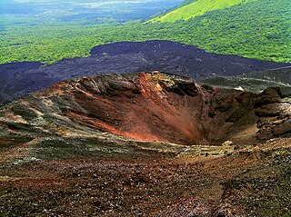
Cerro Negro is an active volcano in the Cordillera de los Maribios mountain range in Nicaragua, about 10 km (6.2 mi) from the village of Malpaisillo. It is a very new volcano, the youngest in Central America, having first appeared in April 1850. It consists of a gravelly basaltic cinder cone, which contrasts greatly with the surrounding verdant hillsides, and gives rise to its name, which means Black Hill. Cerro Negro has erupted frequently since its first eruption. One unusual aspect of several eruptions has been the emission of ash from the top of the cone, while lava erupts from fractures at the base.

The Hōei eruption of Mount Fuji started on December 16, 1707 and ended on February 24, 1708. It was the last confirmed eruption of Mount Fuji, with three unconfirmed eruptions reported from 1708 to 1854. The eruption took place during the reign of Emperor Higashiyama and the Shogun was Tokugawa Tsunayoshi. It is well known for the immense ash-fall it produced over eastern Japan and subsequent landslides and starvation across the country. Hokusai's One Hundred Views of Mount Fuji includes an image of the small crater at a secondary eruption site on the southwestern slope. The area where the eruption occurred is called Mount Hōei because it occurred in the fourth year of the Hōei era. Today, the crater of the main eruption can be visited from the Fujinomiya or Gotemba Trails on Mount Fuji.

Kanlaon, also known as Mount Kanlaon and Kanlaon Volcano, is an active andesitic stratovolcano and the highest mountain on the island of Negros in the Philippines, as well as the highest peak in the Visayas, with an elevation of 2,465 m (8,087 ft) above sea level. Mount Kanlaon ranks as the 42nd-highest peak of an island in the world.

Mount Fuji is a dormant volcano which is the tallest peak in Japan. The latest eruption of Mount Fuji was triggered by an earthquake in 1707. The mountain as it appears now is known as the "New Fuji volcano", which began to erupt about 10,000 years ago. Under the "New Fuji volcano" lies the "Old Fuji volcano", which was active between 100,000 years ago and 10,000 years ago, and the "Komitake volcano", which became active 700,000 years ago.

The Mt. Aso Ropeway was a Japanese aerial lift line in Aso, Kumamoto, operated by Kyūshū Sankō Tourism.

The 1991 eruption of Mount Pinatubo in the Philippines' Luzon Volcanic Arc was the second-largest volcanic eruption of the 20th century, behind only the 1912 eruption of Novarupta in Alaska. Eruptive activity began on April 2 as a series of phreatic explosions from a fissure that opened on the north side of Mount Pinatubo. Seismographs were set up and began monitoring the volcano for earthquakes. In late May, the number of seismic events under the volcano fluctuated from day-to-day. Beginning June 6, a swarm of progressively shallower earthquakes accompanied by inflationary tilt on the upper east flank of the mountain, culminated in the extrusion of a small lava dome.

The 1707 Hōei earthquake struck south-central Japan at around 13:45 local time on 28 October. It was the largest earthquake in Japanese history until it was surpassed by the 2011 Tōhoku earthquake. It caused moderate-to-severe damage throughout southwestern Honshu, Shikoku and southeastern Kyūshū. The earthquake, and the resulting destructive tsunami, caused more than 5,000 casualties. This event ruptured all of the segments of the Nankai megathrust simultaneously, the only earthquake known to have done this, with an estimated magnitude of 8.6 or 8.7 . It possibly also triggered the last eruption of Mount Fuji 49 days later.

The 2002 Mindanao earthquake struck the Philippines at 05:16 Philippine Standard Time on March 6. The world's sixth most powerful earthquake of the year, it registered a magnitude of 7.5 and was a megathrust earthquake. It originated near the Cotabato Trench, a zone of deformation situated between the Philippine Sea plate and the Sunda plate, and occurred very near to the Philippines' strongest earthquake for the 20th century, the 1918 Celebes Sea earthquake.

The 1792 Unzen landslide and tsunami resulted from the volcanic activities of Mount Unzen on 21 May. This caused the collapse of the southern flank of the Mayuyama dome in front of Mount Unzen, resulting in a tremendous tsunami, killing 15,000 people altogether. It was also called Shimabara erupted, Higo affected (島原大変肥後迷惑), since many people were killed by this tsunami in Higo.
The 1880 Southern Luzon earthquakes, were one of the most destructive tremors on record in the history of the country. The shocks continued, with greater or less interruption, from July 14–25, 1880; highlighted by three violent quakes measuring 7.0, Mw 7.6, and Mw 7.2 respectively. The sequence destroyed churches and other buildings, producing loss of life. Coinciding with the tectonic activity was an increase in volcanic activity in the Taal Volcano of southwestern Luzon.

The 2016 Kumamoto earthquakes were a series of earthquakes, including a magnitude 7.0 mainshock which struck at 01:25 JST on April 16, 2016 beneath Kumamoto City of Kumamoto Prefecture in Kyushu Region, Japan, at a depth of about 10 kilometres, and a foreshock earthquake with a magnitude 6.2 at 21:26 JST (12:26 UTC) on April 14, 2016, at a depth of about 11 kilometres.
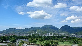
Mount Kinbō or Mount Kinpō is a stratovolcano in the west of Kumamoto city, Kumamoto Prefecture, Japan. It is an extinct stratovolcano and lava dome. Mount Kinbō overlooks the city of Kumamoto and is used for sightseeing and for radio and TV broadcast antennas.