
Okushiri is a town on Okushiri Island, located in Hiyama Subprefecture, Hokkaido, Japan.

The Okhotsk microplate is a proposed minor tectonic plate covering the Kamchatka Peninsula, Magadan Oblast, and Sakhalin Island of Russia; Hokkaido, Kantō and Tōhoku regions of Japan; the Sea of Okhotsk, as well as the disputed Kuril Islands.

Okushiri Island is an island in Hokkaidō, Japan. It has an area of 142.97 square kilometres (55.20 sq mi). The town of Okushiri and the Hiyama Prefectural Natural Park encompass the entire island. It has many pastures, beech tree forests, and a rocky coastline. There are two elementary schools, one junior high school, and one senior high school. Okushiri currently has no colleges or universities.
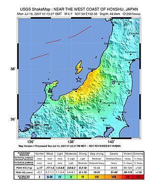
The Chūetsu offshore earthquake) was a powerful magnitude 6.6 earthquake that occurred 10:13 local time on July 16, 2007, in the northwest Niigata region of Japan. The earthquake, which occurred at a previously unknown offshore fault shook Niigata and neighbouring prefectures. The city of Kashiwazaki and the villages of Iizuna and Kariwa registered the highest seismic intensity of a strong 6 on Japan's shindo scale, and the quake was felt as far away as Tokyo. Eleven deaths and at least 1,000 injuries were reported, and 342 buildings were completely destroyed, mostly older wooden structures. Prime Minister Shinzō Abe broke off from his election campaign to visit Kashiwazaki and promised to "make every effort towards rescue and also to restore services such as gas and electricity".

The 2003 Hokkaidō earthquake, scientifically named the 2003 Tokachi-Oki earthquake, occurred off the coast of Hokkaidō, Japan on 26 September at 04:50 local time. At a focal depth of 27 km (17 mi), this great undersea earthquake measured 8.3 on the moment magnitude scale, making it the most powerful earthquake of 2003, as well as one of the most intense earthquakes to hit Japan since modern record-keeping began in 1900.

The 1978 Miyagi earthquake occurred at 17:14 local time on 12 June. The epicentre was offshore of Miyagi Prefecture, Japan. It had a surface-wave magnitude of 7.7, JMA magnitude 7.4, and triggered a small tsunami. The earthquake reached a maximum intensity of Shindo 5 in Sendai and caused 28 deaths and 1,325 injuries.
The 869 Jōgan earthquake and its associated tsunami struck the area around Sendai in the northern part of Honshu on 9 July 869. The earthquake had an estimated magnitude of at least 8.6 on the moment magnitude scale, but may have been as high as 9.0, similar to the 2011 Tōhoku earthquake and tsunami. The tsunami caused widespread flooding of the Sendai plain. In 2001, researchers identified sand deposits in a trench more than 4.5 kilometres (2.8 mi) from the coast as coming from this tsunami.
The 1994 Kuril Islands earthquake – also known as the Hokkaido Toho-oki earthquake – occurred on . The magnitude of this earthquake was put at 8.3, or 8.1. The epicenter was located at about 70 km east of Shikotan Island. The shaking and tsunami caused road and building damage. At least 10 people were reported dead.

The 1994 offshore Sanriku earthquake occurred on December 28, 1994, at 12:19 UTC. This was a magnitude 7.7 earthquake with epicenter located in the Pacific Ocean at about 180 km east of Hachinohe, Aomori. The intensity reached shindo 6 in Hachinohe, Aomori, about 187.6 km from epicenter. It could be felt in Tokyo, about 632.9 km from epicenter, with shindo 2. The Japanese Meteorological Agency put the magnitude at 7.5. Slip associated with this earthquake continued for more than a year and it has been termed an 'ultra-slow earthquake'.
The 2012 Chiba earthquake occurred along the northeastern coast of Chiba Prefecture, Japan at 21:05 JST on Wednesday, 14 March 2012. Although its epicentre lay just offshore near Chōshi city, the shallow magnitude 6.1 Mj earthquake produced considerable shaking inland through much of the Bōsō Peninsula and lower Ibaraki Prefecture. It occurred as a result of normal faulting in a seismically quiet region, possibly in response to the magnitude 9.0 Mw 2011 Tōhoku earthquake.
The 1968 Tokachi earthquake occurred on May 16 at 0:49 UTC in the area offshore of Aomori and Hokkaido. The magnitude of this earthquake was put at 8.3. The intensity of the earthquake reached shindo 5 in Aomori, Aomori and Hakodate, Hokkaido.

The 1983 Sea of Japan earthquake occurred on May 26, 1983, at 11:59:57 local time. It had a magnitude of 7.8 on the moment magnitude scale. It occurred in the Sea of Japan, about 100 km west of the coast of Noshiro in Akita Prefecture, Japan. Out of the 104 fatalities, all but four were killed by the resulting tsunami, which struck communities along the coast, especially Aomori and Akita Prefectures and the east coast of Noto Peninsula. Images of the tsunami hitting the fishing harbor of Wajima on Noto Peninsula were broadcast on TV. The waves exceeded 10 meters (33 ft) in some areas. Three of the fatalities were along the east coast of South Korea. The tsunami also hit Okushiri Island, the site of a more deadly tsunami 10 years later.
The 2019 Yamagata earthquake was an earthquake of magnitude 6.4 which struck primarily the Hokuriku region in Japan on 18 June 2019 at 22:22 JST. The epicenter was close to the city of Tsuruoka, Yamagata. A tsunami warning was also issued.

The 1993 Kushiro–Oki earthquake was one of two large earthquake to strike the Japanese island of Hōkkaido within the same year. The earthquake with a magnitude of 7.6 Mw or 7.8 MJMA struck at 11:06 UTC or 08:06 pm JST on January 15 near the town of Ashoro. Shaking reached a maximum intensity of IX (Violent) on the Mercalli intensity scale, causing considerable damage, and was felt throughout the island, into northern Honshu, Sakhalin, and the Kuril Islands. As a result of the tremors, two people were killed and more than 600 were wounded.

The devastating eruption of Oshima–Ōshima began on 18 August 1741 and ended on 1 May the next year. Eleven days into the eruption, the Kampo tsunami with estimated maximum heights of over 90 m (300 ft) swept across neighboring islands in Japan and the Korean Peninsula. The eruption and its resulting tsunami killed at least 1,400 people. Damage was extreme along the coast of Japan, while in Korea, the tsunami damaged fishing boats.
The Nemuro-Oki earthquake in scientific literature, occurred on June 17 at 12:55 local time. It struck with an epicenter just off the Nemuro Peninsula in northern Hokkaidō, Japan. It measured 7.8–7.9 on the moment magnitude scale (Mw ), 8.1 on the tsunami magnitude scale (Mt ) and 7.4 on the Japan Meteorological Agency magnitude scale (MJMA ).

The 1982 Urakawa earthquake was a 6.9 earthquake that struck off the coast of Urakawa, Japan, on 11:32 (JST), March 21, 1982. The epicenter was 42.1°N 142.6°E. The earthquake was the largest earthquake in the history of the region. The earthquake caused 167 injuries and damage in Tomakomai and Sapporo.

The Shōnai offshore earthquake occurred at around 14:00 on December 7, 1833. It struck with an epicenter in the Sea of Japan, off the coast of Yamagata Prefecture, Japan. A tsunami was triggered by the estimated MJMA 7.5–7.7 earthquake. One hundred and fifty people were killed and there was severe damage in the prefecture.

The 1940 Shakotan earthquake occurred on August 2 at 00:08:22 JST with a moment magnitude (Mw ) of 7.5 and maximum JMA seismic intensity of Shindo 4. The shock had an epicenter off the coast of Hokkaido, Japan. Damage from the shock was comparatively light, but the accomanying tsunami was destructive. The tsunami caused 10 deaths and 24 injuries on Hokkaido, and destroyed homes and boats across the Sea of Japan. The highest tsunami waves were recorded at the coast of Russia while along the coast of Hokkaido, waves were about 2 m.

The eastern margin of the Sea of Japan is a zone of concentrated geological strain which extends several hundred kilometers and north–south along the eastern margin of the Sea of Japan. The margin has undergone convergence tectonics since the end of the Pliocene. It is believed to be an incipient subduction zone which defines the tectonic boundary between the Amurian and Okhotsk plates. This geological zone is seismically active and has been the source of destructive tsunamis. The feature runs off the west coast of Honshu, passes west of the Shakotan Peninsula on Hokkaido and through the Strait of Tartary, between Sakhalin and mainland Russia.


