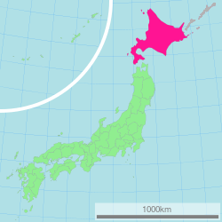
The largest city on Hokkaido is its capital, Sapporo, which is also its only ordinance-designated city. Sakhalin lies about 43 kilometres (27mi) to the north of Hokkaido. To the east and northeast are the Kuril Islands, which are administered by Russia. The four most southerly are claimed by Japan. Hokkaido's position on the northern end of the Japanese archipelago results in a colder climate, with the island seeing significant snowfall each winter. Despite the harsher climate, it serves as an agricultural breadbasket for many crops.
Hokkaido was formerly known as Ezo, Ezochi, and Ezogashima.[5][6] Although Japanese settlers ruled the southern tip of the island since the 16th century, Hokkaido was primarily inhabited by the Ainu people.[7] In 1869, following the Meiji Restoration, the entire island was annexed, colonized, and renamed Hokkaido by Japan.[8][9][10][11][12][13] Japanese settlers dispossessed the Ainu of their land and forced them to assimilate.[7][11] In the 21st century, the Ainu are almost totally assimilated into Japanese society. As a result, the majority of Japanese people of Ainu descent have no knowledge of their heritage or culture.[14][15][16]
When establishing the Development Commission, the Meiji government decided to change the name of Ezochi. Matsuura Takeshirō submitted six proposals, including names such as Kaihokudō (海北道) and Hokkaidō (北加伊道), to the government. The government eventually decided to use the name Hokkaido, but decided to write it as 北海道, as a compromise between 海北道 and 北加伊道 because of the similarity with names such as Tōkaidō (東海道). According to Matsuura, the name was thought up because the Ainu called the region Kai. The kai element also strongly resembles the On'yomi, or Sino-Japanese, reading of the characters 蝦夷 (on'yomi as [ka.i, カイ], kun'yomi as [e.mi.ɕi, えみし]), which have been used for over a thousand years in China and Japan as the standard orthographic form to be used when referring to Ainu and related peoples. It is possible that Matsuura's kai was actually an alteration, influenced by the Sino-Japanese reading of 蝦夷Ka-i, of the Nivkhexonym for the Ainu, namely Qoy (Gilyak pronunciation:[kʰuɣɪ]).[17]
In 1947, Hokkaido became a full-fledged prefecture. The historical suffix 道 (-dō) translates to "prefecture" in English, ambiguously the same as 府 (-fu) for Osaka and Kyoto, and 県 (-ken) for the rest of the prefectures. Dō, as shorthand, can be used to uniquely identify Hokkaido, for example as in 道道 (dōdō, "Hokkaido road")[18] or 道議会 (Dōgikai, "Hokkaido Assembly"),[19] the same way 都 (-to) is used for Tokyo. The prefecture's government calls itself the "Hokkaido Government" rather than the "Hokkaido Prefectural Government".[citation needed]
With the rise of indigenous rights movements, there emerged a notion that Hokkaido should have an Ainu-language name. If a decision to change the name is made, however, whichever Ainu phrase is chosen, its original referent is critically different from the large geographical entity. The phrase aynu mosir (アイヌ モシㇼ) has been a preferred choice among Japanese activists.[20] Its primary meaning is the "land of humans", as opposed to the "land of gods" (kamuy mosir). When contrasted with sisam mosir ("land of the neighbors", often pointing to Honshu or Japanese settlements on the southern tip of Hokkaido), it means the land of the Ainu people, which, depending on context, can refer to Hokkaido,[21] although from a modern ethnolinguistic point of view, the Ainu people have extended their domain to a large part of Sakhalin and the entire Kuril Islands.[citation needed] Another phrase, yaun mosir (ヤウン モシㇼ), has gained prominence; it literally means the "onshore land", as opposed to the "offshore land" (repun mosir), which, depending on context, can refer to the Kuril Islands, Honshu, or any foreign country. If the speaker is a resident of Hokkaido, yaun mosir can refer to Hokkaido.[22] Yet another phrase, akor mosir (アコㇿ モシㇼ) means "our (inclusive) land", and when used by Hokkaido Ainus, it can refer to Hokkaido or Japan as a whole.[21]
During the Jomon period, the local culture and the associated hunter-gatherer lifestyle flourished in Hokkaido, beginning over 15,000 years ago. In contrast to the island of Honshu, Hokkaido saw an absence of conflict during this time period. Jomon beliefs in natural spirits are theorized to be the origins of Ainu spirituality. About 2,000 years ago, the island was colonized by Yayoi people, and much of the island's population shifted away from hunting and gathering towards agriculture.[23]
The Ebetsu Kofun Cluster is a group of mounds dating from the latter half of the 8th century to the middle of the 9th century, and were surveyed by Juichi Goto in 1931. Along with the kofun, warabidetoh (蕨手刀), iron sword, magatama, and sueki were discovered.[24] Ebetsu Kofun is known to be evidence for the existence of Wajin (和人) and trade between Hokkaido and Honshu before Feudal Japan.
The Nihon Shoki, finished in 720 AD, is often said to be the first mention of Hokkaido in recorded history. According to the text, Abe no Hirafu[25] led a large navy and army to the northern areas from 658 to 660 and came into contact with the Mishihase and Emishi. One of the places Hirafu went to was called Watarishima (渡島) and he extabilished domain(郡) of Yamato Kingship. Watarishima is often believed to be present-day Hokkaido. However, many theories exist concerning the details of this event, including the location of Watarishima and the common belief that the Emishi in Watarishima were the ancestors of the present-day Ainu people.[citation needed]
During the Nara and Heian periods (710–1185), people in Hokkaido conducted trade with Dewa Province, an outpost of the Japanese central government. From the feudal period, the people in Hokkaido began to be called Ezo. Hokkaido subsequently became known as Ezochi (蝦夷地; lit. 'Ezo land' or 'Ezo region')[26] or Ezogashima (蝦夷ヶ島; lit. 'Island of the Ezo').[27] The indigenous people of Ezochi mainly relied upon hunting and fishing and obtained rice and iron through trade with the Japanese.[citation needed]
Feudal Japan
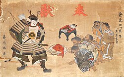
A palace reception near Hakodate in 1751. Ainu bringing gifts (cf.omusha)
During the Muromachi period (1336–1573), the Japanese established a settlement at the south of the Oshima Peninsula, with a series of fortified residences such as that of Shinoridate. As more people moved to the settlement to avoid battles, disputes arose between the Japanese and the Ainu. The disputes eventually developed into a war. In 1457, Takeda Nobuhiro (1431–1494) killed the Ainu leader, Koshamain,[25] and defeated the opposition. Nobuhiro's descendants became the rulers of the Matsumae-han, which was granted exclusive trading rights with the Ainu in the Azuchi-Momoyama and Edo periods (1568–1868). The Matsumae family's economy relied upon trade with the Ainu, who had extensive trading networks.[28] The Matsumae held authority over the south of Ezochi until the end of the Edo period.[5]
The Matsumae clan's rule over the Ainu must be understood[29] in the context of the expansion of the Japanese feudal state. Medieval military leaders in northern Honshu (e.g. Northern Fujiwara, Akita clan) maintained only tenuous political and cultural ties to the imperial court and its proxies, the Kamakura shogunate and Ashikaga shogunate. Feudal strongmen sometimes defined their own roles within the medieval institutional order, taking shogunate titles, while in other times they assumed titles that seemed to give them a non-Japanese identity. Many of the feudal strongmen were descended from Emishi military leaders who had been assimilated into Japanese society.[29]
The Matsumae clan were of Yamato descent like other ethnic Japanese people, whereas the Emishi of northern Honshu were a distinctive group related to the Ainu. The Emishi were conquered and integrated into the Japanese state dating as far back as the 8th century and as a result began to lose their distinctive culture and ethnicity as they became minorities. By the time the Matsumae clan ruled over the Ainu, most of the Emishi were ethnically mixed and physically closer to Japanese than they were to Ainu. From this, the "transformation" theory postulates that native Jomon peoples changed gradually with the infusion of Yayoi immigrants into the Tōhoku region of northern Honshu, in contrast to the "replacement" theory that posits the Jomon were replaced by the Yayoi.[30]
There were numerous revolts by the Ainu against feudal rule. The last large-scale resistance was Shakushain's revolt in 1669–1672. In 1789, a smaller movement known as the Menashi–Kunashir rebellion was crushed, after which the terms "Japanese" and "Ainu" referred to clearly distinguished groups, and the Matsumae were unequivocally Japanese.[citation needed]
According to American professor of Japanese history John A. Harrison, prior to 1868 Japan used proximity as its claim to Hokkaido, Sakhalin, and the Kuril Islands. However, Japan had never thoroughly explored, governed, or exploited the areas, and this claim was invalidated by the movement of Russia into the Northeast Pacific area and by Russian settlements on Kamchatka (from 1699), Sakhalin (1850s) and the Sea of Okhotsk Coast (1640s onwards).[31]
Prior to the Meiji Restoration of 1868, Hokkaido was seen as a frontier land and the Tokugawa shogunate realized the need to prepare northern defenses against a possible Russian invasion and took over control of most of Ezochi in 1855–1858.[32][33] Many Japanese settlers regarded the Ainu as "inhuman and the inferior descendants of dogs".[11][34] The Tokugawa irregularly imposed various assimilation programs on the Ainu due to the Tokugawa's perception of them as a threat from Russia.[11] For example, assimilation programs were implemented in response to perceived threats from Russia, which included the Laxman expedition[ru] of 1793 and the Golovnin Incident of 1804.[11] Once the respective Russian threats appeared to subside, the assimilation programs were halted until 1855.[11] However, in 1855, once the Treaty of Shimoda was signed, which defined the borders between Russian Empire and Tokugawa Japan, the Tokugawa again viewed Russia as a threat to Japanese sovereignty over Hokkaido and reinstated assimilation programs on the Ainu.[11]
Prior to the Meiji era, the island was called Ezochi, which can be translated as "land of the barbarians" or "the land for people who did not obey the government."[6] Shortly after the Boshin War in 1868, a group of Tokugawa loyalists led by Enomoto Takeaki temporarily occupied the island (the polity is commonly but mistakenly known as the Republic of Ezo), but the rebellion was defeated in May 1869. Through colonial practices, Ezochi was annexed into Japanese territory.[6][11][13][12] Ezochi was subsequently put under control of Hakodate Prefectural Government. When establishing the Development Commission (開拓使, Kaitakushi), the Meiji government introduced a new name, Hokkaido, which can be translated to "northern sea route".[5] Regional subdivisions were established, including the provinces of Oshima, Shiribeshi, Iburi, Ishikari, Teshio, Kitami, Hidaka, Tokachi, Kushiro, Nemuro and Chishima.[35]
Japanese proponents of Ezochi's colonization argued that it would serve as a strategic move to enhance Japan's standing and influence on the global stage, particularly in negotiations with Western powers, specifically Russia.[36] The Meiji government invested heavily in colonizing Hokkaido for several reasons.[10] Firstly, they aimed to assert their control over the region as a buffer against potential Russian advances.[10] Secondly, they were attracted to Hokkaido's rich natural resources, including coal, timber, fish, and fertile land.[10] Lastly, since Western powers viewed colonial expansion as a symbol of prestige, Japan viewed the colonization of Hokkaido as an opportunity to present itself as a modern and respected nation to Western powers.[10]
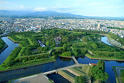
The Goryōkaku fort in HakodateThe Ainu, Hokkaido's indigenous people
The primary purpose of the Development Commission was to secure Hokkaido before the Russians extended their control of the Far East beyond Vladivostok. The Japanese failed to settle in the interior lowlands of the island because of aboriginal resistance.[37] The resistance was eventually destroyed, and the lowlands were under the control of the commission.[37] The most important goal of the Japanese was to increase the farm population and to create a conducive environment for emigration and settlement.[37] However, the Japanese did not have expertise in modern agricultural techniques, and only possessed primitive mining and lumbering methods.[37]Kuroda Kiyotaka was put in charge of the project, and turned to the United States for help.[37]
His first step was to journey to the United States and recruit Horace Capron, US President Ulysses S. Grant's commissioner of agriculture. From 1871 to 1873, Capron bent his efforts to expounding Western agriculture and mining, with mixed results. Frustrated with obstacles to his efforts, Capron returned home in 1875. In 1876, William S. Clark arrived to establish an agricultural college in Sapporo. Although he only remained for a year, Clark left a lasting impression on Hokkaido, inspiring the Japanese with his teachings on agriculture as well as Christianity.[38] His parting words, "Boys, be ambitious!", can be found on public buildings in Hokkaido to this day. The population of Hokkaido increased from 58,000 to 240,000 during that decade.[39]
Kuroda hired Capron for US$10,000 per year and paid for all expenses related to the mission. Kuroda and his government were likely intrigued by Capron's previous colonial experience, particularly his involvement in the forced removal of Native Americans from Texas to new territories after the Mexican–American War.[9] Capron introduced capital-intensive farming techniques by adopting American methods and tools, importing seeds for Western crops, and bringing in European livestock breeds, which included his favorite North Devon cattle.[9] He founded experimental farms in Hokkaido, conducted surveys to assess mineral deposits and agricultural potential, and advocated for improvements in water access, mills, and roads.[9]
The settler colonization of Hokkaido by the Japanese was organized and supported through collaboration between the Japanese state and American experts and technology.[9] From the 1870s to the 1880s, Japanese leaders placed their efforts on settling Hokkaido by systematically migrating former samurai lords, samurai retainers, and common citizens, which included farmers and peasants, providing them with "free" land and financial assistance.[9] This transformation was facilitated with the expertise of American advisors who introduced various colonization technologies, transforming Hokkaido into land suitable for Japan's capitalist aspirations.[9]
Japanese leaders drew inspiration from American settler colonialism during their diplomatic visits to the United States.[10] Japanese colonial officials learned settler colonial techniques from Western imperial powers, particularly the United States. This included declaring large portions of Hokkaido as ownerless land, providing a pretext for the dispossession of the Ainu people.[10][40] Japan established the Hokkaido Colonization Board in 1869, a year after the start of the Meiji era, with the goal of encouraging Japanese settlers to Hokkaido.[41] Mainland Japanese settlers began migrating to Hokkaido, leading to Japan's colonization of the island.[40] Motivated by capitalist and industrial goals, the Meiji government forcefully appropriated fertile land and mineral-rich regions throughout Hokkaido, without consideration for their historical Ainu inhabitancy.[40] The Meiji government implemented land seizures and enacted land ownership laws that favored Japanese settlers, effectively stripping Ainu people of their customary land rights and traditional means of subsistence.[40] The 1899 Hokkaido Former Aborigines Protection Act further marginalized and impoverished the Ainu people by forcing them to leave their traditional lands and relocating them to the rugged, mountainous regions in the center of the island.[42][43] The act prohibited the Ainu from fishing and hunting, which were their main source of subsistence.[44] The Ainu were valued primarily as a source of inexpensive manual labor, and discriminatory assimilation policies further entrenched their sense of inferiority as well as worsened poverty and disease within Ainu communities.[45] These policies exacerbated diasporic trends among the Ainu population, as many sought employment with the government or private enterprises, often earning meager wages that barely sustained their families.[40]
The Meiji government embarked on assimilation campaigns aimed not only at assimilating the Ainu but also eradicating their language and culture entirely.[40] They were forced to take on Japanese names and language, and gradually saw their culture and traditions eroded.[42] The Ainu were forbidden to speak their own language and taught only Japanese at school.[41] Facing pervasive stigma, many Ainu concealed their heritage.[42]UNESCO has recognized the Ainu language as critically endangered.[46] Given the Meiji state's full political control over the island, the subsequent subjugation of its indigenous inhabitants, aggressive economic exploitation, and ambitious permanent settlement endeavors, Hokkaido emerged as the sole successful settler colony of Japan.[40]
After the Meiji colonization of Hokkaido, Meiji Japan depended on prison labour to accelerate the colonization process.[11] The Japanese built three prisons and rendered Hokkaido a prison island, where political prisoners were incarcerated and used as prison labour.[11] During the opening ceremony of the first prison, the Ainu name "Shibetsuputo" was replaced with the Japanese name "Tsukigata", as an attempt to "Japanize" Hokkaido's geography.[11] The second prison opened near the Hokutan Horonai coal mine, where Ainu people were forced to work.[11] Cheap prison labour played an important role in coal and sulphur mining, as well as road construction in Hokkaido.[11] Eventually, several types of indentured labour, Korean labour, child labour and women labour replaced convict labour in Hokkaido.[11] Working conditions were difficult and dangerous.[11] Japan's transition to capitalism depended heavily on the growth of the coal mining sector in Hokkaido.[11] The importance of coal from Hokkaido increased throughout World War I, and the mines required a large amount of labourers.[11]
Hokkaido became equal with other prefectures in 1947, when the revised Local Autonomy Act became effective. The Japanese central government established the Hokkaido Development Agency (北海道開発庁, Hokkaidō Kaihatsuchō) as an agency of the Prime Minister's Office in 1949 to maintain its executive power in Hokkaido. The agency was absorbed by the Ministry of Land, Infrastructure and Transport in 2001. The Hokkaido Bureau (北海道局, Hokkaidō-kyoku) and the Hokkaidō Regional Development Bureau (北海道開発局, Hokkaidō Kaihatsukyoku) of the ministry still have a strong influence on public construction projects in Hokkaido.
There are three populations of the Ussuri brown bear found on the island. There are more brown bears in Hokkaido than anywhere else in Asia besides Russia. The Hokkaido brown bear is separated into three distinct lineages. There are only eight lineages in the world.[49] Those on Honshu died out long ago.
Hokkaido is also the historical and current range of Japan's sea otter population, which is increasingly becoming a major tourism draw as sea otters disappear from Japanese aquaria.[50]
The native conifer species in northern Hokkaido is the Sakhalin fir (Abies sachalinensis).[51] The flowering plant Hydrangea hirta is also found on the island.
Like many areas of Japan, Hokkaido is seismically active. Aside from numerous earthquakes, the following volcanoes are considered still active (at least one eruption since 1850):
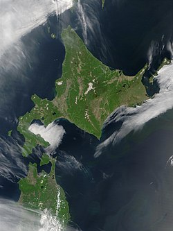
Satellite image of Hokkaido in winter, January 2003Hokkaido in winter and summer
As Japan's coldest region, Hokkaido has relatively cool summers and icy/snowy winters. Most of the island falls in the humid continental climate zone with Köppen climate classificationDfb (hemiboreal) in most areas but Dfa (hot summer humid continental) in some inland lowlands. The average August temperature ranges from 17 to 22°C (62.6 to 71.6°F), while the average January temperature ranges from −12 to −4°C (10.4 to 24.8°F), in both cases depending on elevation and distance from the ocean, though temperatures on the western side of the island tend to be a little warmer than on the eastern. The highest temperature ever recorded is 39.5°C (103.1°F) on 26 May 2019.[56]
The northern portion of Hokkaido falls into the taiga biome[57] with significant snowfall. Snowfall varies widely from as much as 11 metres (400in) on the mountains adjacent to the Sea of Japan down to around 1.8 metres (71in) on the Pacific coast. The island tends to have isolated snowstorms that develop long-lasting snowbanks. Total precipitation varies from 1,600 millimetres (63in) on the mountains of the Sea of Japan coast to around 800 millimetres (31in) (the lowest in Japan) on the Sea of Okhotsk coast and interior lowlands and up to around 1,100 millimetres (43in) on the Pacific side. The generally high quality of powder snow and numerous mountains in Hokkaido make it a popular region for snow sports. The snowfall usually commences in earnest in November and ski resorts (such as those at Niseko, Furano, Teine and Rusutsu) usually operate between December and April. Hokkaido celebrates its winter weather at the Sapporo Snow Festival.[citation needed]
Hokkaido’s winter snowfall is driven by a seasonal atmospheric pattern between Siberia and the North Pacific. During winter, the Eurasian continent receives limited solar energy and cools rapidly, forming a strong and persistent high-pressure system over Siberia known as the Siberian High. At the same time, the North Pacific retains heat longer and forms a persistent low-pressure system called the Aleutian Low. The resulting pressure difference generates steady northwesterly winds that carry very cold, dry air toward Japan. As this air crosses the Sea of Japan, it passes over the Tsushima Warm Current, which keeps coastal waters relatively warm and enables significant moisture uptake. When the moisture-laden air reaches Hokkaido’s mountainous coastline, it is forced upward, condenses, and produces significant snowfall.[58] This is an effect often referred to as ocean-effect snowfall. Despite the common assumption that La Niña brings heavier snow, long-term observations show no consistent correlation between La Niña phases and increased snowfall in Hokkaido.[59]
During the winter, passage through the Sea of Okhotsk is often complicated by large floes of drift ice. Combined with high winds that occur during winter, this frequently brings air travel and maritime activity to a halt beyond the northern coast of Hokkaido. Ports on the open Pacific Ocean and Sea of Japan are generally ice-free year round, though most rivers freeze during the winter.[citation needed]
Unlike the other major islands of Japan, Hokkaido is normally not affected by the June–July rainy season and the relative lack of humidity and typically warm, rather than hot, summer weather makes its climate an attraction for tourists from other parts of Japan.[citation needed]
Temperature comparison
Monthly average highs and lows for various cities and towns in Hokkaido in Celsius and Fahrenheit
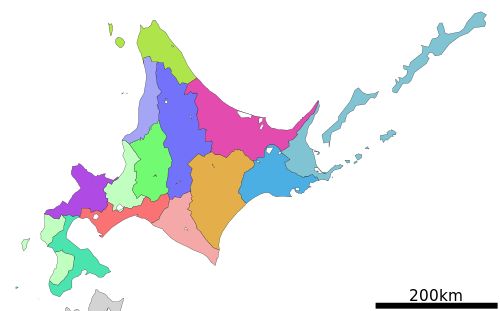
A map of Hokkaido showing the pre-2010 subprefectures and the primary citiesA map of Hokkaido within Japan, including the disputed Kuril islands
As of April2010[update], Hokkaido has nine General Subprefectural Bureaus (総合振興局) and five Subprefectural Bureaus (振興局). Hokkaido is one of eight prefectures in Japan that have subprefectures (支庁 shichō). Hokkaido is the only one of the eight to have such offices covering the whole of its territory outside the main cities, rather than having them just for outlying islands or remote areas.
This is mostly because of its great size. Many parts of the prefecture are simply too far away to be effectively administered by Sapporo. Subprefectural offices in Hokkaido carry out many of the duties that prefectural offices fulfill elsewhere in Japan.
* Japan claims the southern part of Kuril Islands (Northern Territories), currently administered by Russia, belong to Nemuro Subprefecture divided into six villages. However, the table above excludes these islands' data.
Municipalities
Hokkaido is divided into 179 municipalities.
A map of Hokkaido by type of municipality Government Ordinance Designated CityCityTownVillage
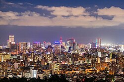
Skyline of Sapporo city, the most populous city in Hokkaido and the 5th most populous city in JapanHokkaido population pyramid in 2020
Hokkaido has the third-largest population of Japan's five main islands, with 5,111,691 people as of 2023[update].[4][61] It has the lowest population density in Japan, with just 61 inhabitants per square kilometre (160/sqmi). Hokkaido ranks 21st in population among the world's islands. Major cities include Sapporo and Asahikawa in the central region, and the port of Hakodate facing Honshu in the south. Sapporo is Hokkaido's largest city and the fifth-largest in Japan. It had a population of 1,959,750 as of 31July2023[update] and a population density of 1,748/km2 (4,530/sqmi).
Although there is some light industry (most notably paper milling and beer brewing) most of the population is employed by the service sector. In 2001, the service sector and other tertiary industries generated more than three-quarters of the gross domestic product.[64]
Agriculture and other primary industries play a large role in Hokkaido's economy. Hokkaido has nearly one fourth of Japan's total arable land. It ranks first in the nation in the production of a host of agricultural products, including wheat, soybeans, potatoes, sugar beets, onions, pumpkins, corn, raw milk, and beef. Hokkaido also accounts for 22% of Japan's forests with a sizable timber industry. The prefecture is first in the nation in production of marine products and aquaculture.[64] The average farm size in Hokkaido is 26 hectares per farmer in 2013, which is almost 11 times bigger than the national average of 2.4 hectares.[65]
Tourism is an important industry, especially during the cool summertime when visitors are attracted to Hokkaido's open spaces from hotter and more humid parts of Japan and other Asian countries. During the winter, skiing and other winter sports bring other tourists, and increasingly international ones, to the island.[66]
Coal mining played an important role in the industrial development of Hokkaido, with the Ishikari coalfield. Cities such as Muroran were primarily developed to supply the rest of the archipelago with coal.[23]
In 2023, Rapidus Corporation announced Hokkaido's largest business investment with a 5 trillion yen plan to build a semiconductor manufacturing factory in Chitose. The site is expected to eventually employ over 1,000 employees.[67]
Hokkaido's only land link to the rest of Japan is the Seikan Tunnel. Most travellers travel to the island by air: the main airport is New Chitose Airport at Chitose, just south of Sapporo. One of the airlines, Air Do was named after Hokkaido.
Hokkaido can be reached by ferry from Sendai, Niigata and some other cities, with the ferries from Tokyo dealing only in cargo. The Hokkaido Shinkansen takes passengers from Tokyo to near Hakodate in slightly over four hours.[68] There is a fairly well-developed railway network, but many cities can be accessed only by road. The coal railways were constructed around Sapporo and Horonai during the late 19th century, as advised by American engineer Joseph Crawford.[23]
Hokkaido is home to one of Japan's Melody Roads, which is made from grooves cut into the ground, which when driven over causes a tactile vibration and audible rumbling transmitted through the wheels into the car body.[69][70]
The Hokkaido Prefectural Board of Education oversees public schools (except colleges and universities) in Hokkaido. Public elementary and junior high schools are operated by municipalities, except Hokkaido Noboribetsu Akebi Secondary School and schools attached to the Hokkaido University of Education. Public high schools are operated by either the prefectural board or municipalities.
As of 2016[update],[71] there are 291 high schools in Hokkaido: 4 national schools, 55 private schools,[72] 233 public schools,[73] and 2 integrated junior-senior schools.
Hokkaido has 34 universities (7 national, 6 local public, and 21 private universities), 15 junior colleges, and 6 colleges of technology (3 national, 1 local public, and 2 private colleges).
Hokkaido enjoys a special status in professional sumo as the prefecture that has produced the most yokozuna in Japan. A total of eight wrestlers have achieved the highest rank in the professional hierarchy: Chiyonoyama, Yoshibayama, Taihō, Kitanofuji, Kitanoumi, Chiyonofuji, Hokutoumi, and Ōnokuni.[74] Historically, the prefecture only experienced a boom in sporting success after the Meiji era, because during this period of economic development and high birth rates, it was common to send young boys to sumo stables in order to limit the number of mouths to feed.[75] The prefecture's golden age came during the Shōwa and Heisei periods, with Chiyonofuji, Hokutoumi, and Ōnokuni all reaching the rank of yokozuna and Hokuten'yū reaching the rank of ōzeki at the same time. Since then, the prefecture has slowed down considerably, with the last title won by a native of the prefecture taking place in 1991. On the amateur scene, only five high school clubs participating in national tournaments have more than 16 members, according to a 2020 study.[76]
Shōwa-Shinzan International Yukigassen - competitive snowballing
Sōunkyō Ice Festival
Politics
Governor
The current governor of Hokkaido is Naomichi Suzuki.[77] He won the governorship in the gubernatorial election in 2019 as an independent. In 1999, Hori was supported by all major non-Communist parties and Itō ran without party support. Before 1983, the governorship had been held by Liberal Democrats Naohiro Dōgakinai and Kingo Machimura for 24 years. In the 1971 election when Machimura retired, the Socialist candidate Shōhei Tsukada lost to Dōgakinai by only 13,000 votes;[78] Tsukada was also supported by the Communist Party – the leftist cooperation in opposition to the US-Japanese security treaty had brought joint Socialist-Communist candidates to victory in many other prefectural and local elections in the 1960s and 1970s. In 1959, Machimura had defeated Yokomichi's father Setsuo in the race to succeed Hokkaido's first elected governor, Socialist Toshibumi Tanaka who retired after three terms. Tanaka had only won the governorship in 1947 in a run-off election against Democrat Eiji Arima because no candidate had received the necessary vote share to win in the first round as required by law at the time.
Assembly
The Hokkaido Legislative Assembly has 100 members from 47 electoral districts. As of April 2015, the LDP caucus holds a majority with 51 seats, the DPJ-led group has 26 members. Other groups are the Hokkaido Yūshikai of New Party Daichi and independents with twelve seats, Kōmeitō with eight, and the Japanese Communist Party with four members.[79] General elections for the Hokkaido assembly are currently held together with gubernatorial elections in the unified local elections (last round: April 2015).
For the lower house of the National Diet, Hokkaido is divided into twelve single-member electoral districts. In the 2017 election, candidates from the governing coalition of Liberal Democrats and Kōmeitō won seven districts and the main opposition Constitutional Democrats five. For the proportional election segment, Hokkaido and Tokyo are the only two prefectures that form a regional "block" district of their own. The Hokkaido proportional representation block elects eight Representatives.
In 2017, the Liberal Democratic Party received 28.8% of the proportional vote and won three seats, the Constitutional Democratic Party won three (26.4% of the vote), one seat each went to Kibō no Tō (12.3%) and Kōmeitō (11.0%). The Japanese Communist Party, who won a seat in 2014, lost their seat in 2017 while receiving 8.5% of the votes.
In the upper house of the National Diet, a major reapportionment in the 1990s halved the number of Councillors from Hokkaido per election from four to two. After the elections of 2010 and 2013, the Hokkaido electoral district – like most two-member districts for the upper house – is represented by two Liberal Democrats and two Democrats. In the 2016 upper house election, the district magnitude will be raised to three, Hokkaido will then temporarily be represented by five members and six after the 2019 election.
International relations
Hokkaido has relationships with several provinces, states, and other entities worldwide.[80]
↑Mason, Michele (2012). Dominant Narratives of Colonial Hokkaido and Imperial Japan: Envisioning the Periphery and the Modern Nation-State. Palgrave Macmillan. pp.7–9. ISBN978-1-349-45025-1.
12"Recent History of the Ainu"(PDF). The Culture and Recent History of the Ainu. Hokkaido Museum. Archived from the original(PDF) on 14 August 2024. Retrieved 22 January 2025.
↑Lie, John (2009) [2001]. Multiethnic Japan (reviseded.). Cambridge, Massachusetts: Harvard University Press. pp.89–90. ISBN978-0-674-04017-5. Retrieved 15 March 2024. By the fifteenth century Ainu people were principally hunter-fisher-gatherers and engaged in far-flung trade with others, ranging from Aleutian islanders to the east, Russians and Chinese to the west, and Shamo (as the Ainu call Wajin, or Japanese people) to the south [....].
12Howell, David. "Ainu Ethnicity and the Boundaries of the Early Modern Japanese State", Past and Present 142 (February 1994), p. 142
↑Ossenberg, Nancy (see reference) has the best evidence of this relationship with the Jōmon. Also, a newer study, Ossenberg, et al., "Ethnogenesis and craniofacial change in Japan from the perspective of nonmetric traits" (Anthropological Science v.114:99–115) is an updated analysis published in 2006 which confirms this finding.
↑Harrison, John A. (1951). "The Capron Mission and the Colonization of Hokkaido, 1868-1875". Agricultural History. 25 (3): 135–136. JSTOR3740831.
↑"Hokkaido and Karafuto: Japan's Internal Frontier". Population Index. 12 (1): 6–13. 1946. doi:10.2307/2730453. JSTOR2730453.
↑The American Asian Review. Vol.13. New York: Institute of Asian Studies, St. John's University. 1995. p.77. Retrieved 15 March 2024. Using the expressive sound 'ah', and the Japanese copula da ('it is'), wajin encountering an Ainu person would shout out the insulting pun, 'ah, inu da,' 'It's an Ainu' or 'Oh, it's a dog!'
1234567Mason, Michele (2012). Dominant Narratives of Colonial Hokkaido and Imperial Japan: Envisioning the Periphery and the Modern Nation-State. Palgrave Macmillan. pp.7–9. ISBN978-1-349-45025-1.
↑"Ainu in Japan". Minority Rights Group. Retrieved 22 January 2025.
↑"Chapter VII: 1945". The Official Chronology of the US Navy in World War II. Hyperwar. Archived from the original on 2 October 2020. Retrieved 20 September 2011.
12"Hokkaido's Business Environment". Trade and Economic Exchange Group, Commerce and Economic Exchange Division, Department of Economic Affairs, Hokkaido Government. Archived from the original on 2010-07-21. Retrieved 2008-12-05.
McDougall, Walter A. (1993). Let the Sea Make a Noise: A History of the North Pacific from Magellan to MacArthur. New York: Basic Books. ISBN9780465051526; OCLC 28017793
This page is based on this Wikipedia article Text is available under the CC BY-SA 4.0 license; additional terms may apply. Images, videos and audio are available under their respective licenses.