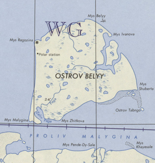
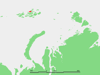
Bely Island is a relatively large island in the Kara Sea off the tip of the Yamal Peninsula, Siberia, Russia. Close to the island's northwest tip, there is the Russian Experiment Station Popov Station.

Hooker Island is one of the central islands of Franz Josef Land. It is located in the central area of the archipelago at 80.23°N 53.02°E. It is administered by the Arkhangelsk Oblast, Russia.
Jackson Island is an island located in Franz Josef Land, Arkhangelsk Oblast, Russian Federation. This island is part of the Zichy Land subgroup of the central part of the archipelago.

Wilczek Island, is located in the southeastern end of Franz Josef Land, Arkhangelsk Oblast, Russia.
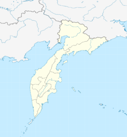
Karaginsky Island or Karaginskiy Island is an island in the Karaginsky Gulf of the Bering Sea. The 40 km-wide strait between the Kamchatka Peninsula and this island is called Litke Strait. Karaginsky Island is a Ramsar site.

Russky Island is an island in Peter the Great Gulf in the Sea of Japan, in Primorsky Krai, Russia. It is the largest island in the Eugénie Archipelago, separated from the Muravyov-Amursky Peninsula immediately to the north by the Eastern Bosphorus, and is one of the four islands in Primorsky Krai that are permanently inhabited with a population of 5360 (2010).

Hall Island is an island in Franz Josef Land, Arkhangelsk Oblast, Russia.

La Ronciere Island (Russian: Остров Ла-Ронсьер, translit. Ostrov La-Ronsier, also known as Ronser Island, is an island in Franz Josef Land, Russia.

Heiss Island is an island in Franz Josef Land, Russia. It is located in the central area of the archipelago, north of Hall Island, between Champ Island and Wilczek Land. Its area is 132 km².

Sverdrup Island or Svordrup Island is an isolated island in the southern region of the Kara Sea. This island is covered with tundra vegetation. It is located 120 km north of Dikson on the Siberian coast. The nearest land mass is the Arkticheskiy Institut Islands, about 90 km to the northeast. The island has a wide bay opening towards the west. Its length is 15 km and its maximum width 10 km.
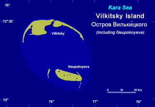
Vilkitsky Island, is an island in the Kara Sea. It is located 40 km northeast of Shokalskogo Island, off the tip of the Gydan Peninsula in North Siberia.
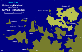
Kolosovykh Island is an island, in the Kara Sea off the coast of Siberia.

The Yenisei Gulf is a large and long estuary through which the lower Yenisei River flows into the Kara Sea.

Taymyr Island, Russian: Остров Таймыр(Ostrov Taymyr), is a large island in the coast of the Kara Sea. Its length is 33 km (21 mi) and its average width about 10 km (6.2 mi). This island is located west of the Taymyr Gulf in an area of skerries right off the western coast of the Taymyr Peninsula. The narrow strait between Taymyr island and the Siberian coast is called Proliv Taymyrskiy It is about 3 km (1.9 mi) wide on average.

The Taymyr Gulf is a gulf in the Kara Sea that includes the estuary of the Lower Taymyr River.
Nansen Island, is a long and narrow island in the coast of the Kara Sea. Its length is 21 km (13 mi) and its average width about 2.5 km (1.6 mi). This island is located in an area of skerries right off the western coast of the Taymyr Peninsula.

The Saint Peter Islands, also known as Saint Petra Islands or Petra Islands are two islands covered with tundra vegetation, shingle and ice. These islands, as well as some other islands nearby were originally named after Christian Apostles. The climate is Arctic and severe with frequent blizzards in the winter. The sea surrounding these Islands is covered with fast ice most of the year and is obstructed by pack ice even in the summer, so that these islands are merged with the mainland and animals can go across the ice.
The Routan Islands(Chukot: Ровтын иӆирти Rovtįn iłirti) are two islands in the eastern coast of the Chaunskaya Bay of the East Siberian Sea. They are located directly off Pevek, separated from the shore of the Pevek Peninsula by a 4.7 km wide sound. Ayon Island lies on the other side of the Chaunskaya Bay, 24 km to the west.

Trety Island or Treti Island is a relatively large island in the western shores of the Shelikhov Bay, at the northern end of the Sea of Okhotsk. It is located 4 km to the south of a peninsula that encloses a small bay in an area that is largely uninhabited.

Qum Island or Peschanniy, Azeri: Qum adası) is an island in the Bay of Baku, in the Caspian Sea.