The Kuril Islands or Kurile Islands are a volcanic archipelago administered as part of Sakhalin Oblast in the Russian Far East. The islands stretch approximately 1,300 km (810 mi) northeast from Hokkaido in Japan to Kamchatka Peninsula in Russia, separating the Sea of Okhotsk from the north Pacific Ocean. There are 56 islands and many minor islets. The Kuril Islands consist of the Greater Kuril Chain and, at the southwest end, the parallel Lesser Kuril Chain. They cover an area of around 10,503.2 square kilometres (4,055.3 sq mi), with a population of roughly 20,000.

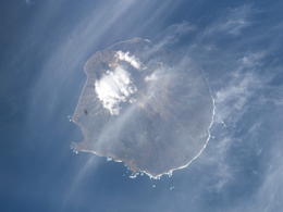
Atlasov Island, known in Russian as Ostrov Atlasova (Остров Атласова), or in Japanese as Araido (阿頼度島), is the northernmost island and volcano and also the highest volcano of the Kuril islands, part of the Sakhalin Oblast in Russia. The Russian name is sometimes rendered in English as Atlasova Island. Other names for the island include Uyakhuzhach, Oyakoba (Ainu) and Alaid, the name of the volcano on the island.

Paramushir is a volcanic island in the northern portion of the Kuril Islands chain in the Sea of Okhotsk in the northwest Pacific Ocean. It is separated from Shumshu by the very narrow Second Kuril Strait in the northeast 2.5 km (1.6 mi), from Antsiferov by the Luzhin Strait to the southwest, from Atlasov in the northwest by 20 km (12 mi), and from Onekotan in the south by the 40 km (25 mi) wide Fourth Kuril Strait. Its northern tip is 39 km (24 mi) from Cape Lopatka at the southern tip of the Kamchatka Peninsula. Its name is derived from the Ainu language, from “broad island” or “populous island”. Severo-Kurilsk, the administrative center of the Severo-Kurilsky district, is the only permanently populated settlement on Paramushir island.

Onekotan is an uninhabited volcanic island located near the northern end of the Kuril Islands chain in the Sea of Okhotsk in the northwest Pacific Ocean. Its name is derived from the Ainu language for "large village”. It is the second largest island, after Paramushir, in the northern subgroup of the Kurils. It is administratively included in the Severo-Kurilsky District of Sakhalin oblast, Russia.

Matua is an uninhabited volcanic island near the center of the Kuril Islands chain in the Sea of Okhotsk in the northwest Pacific Ocean, 16 km (9.9 mi) across Golovnin Strait from Raikoke. Its name is derived from the Ainu language, from “hellmouth”.
Antsiferov Island is an uninhabited volcanic island located in the northern Kuril Islands chain in the Sea of Okhotsk in the northwest Pacific Ocean. Its former Japanese name is derived from the Ainu language for "place of tall waves". Its nearest neighbor is Paramushir, located 15 km away across the Luzhin Strait. It is currently named for the cossack explorer Danila Antsiferov, who first described it along with other northern Kuril islands in the early eighteenth century.

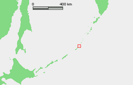
Broutona is an uninhabited volcanic island located near the northern end of the southern Kuril Islands chain in the Sea of Okhotsk in the northwest Pacific Ocean. Its name is derived from William Robert Broughton, a British ship captain who charted many of the Kuril Islands during his voyages during the 18th century. Its original Ainu name was Makanruru, which translates roughly to "island in a strong current".

Chirinkotan is an uninhabited volcanic island located in the centre of the Kuril Islands chain in the Sea of Okhotsk in the northwest Pacific Ocean. Its name is derived from the Ainu language for "mudslide". It is located 3 kilometres west of Ekarma, its nearest neighbor.

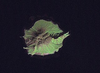
Ekarma is an uninhabited volcanic island near the center of the Kuril Islands chain in the Sea of Okhotsk in the northwest Pacific Ocean, separated from Shiashkotan by the Ekarma Strait. Its name is derived from the Ainu language, from “safe anchorage”.

Kharimkotan ; Japanese 春牟古丹島; Harimukotan-tō, alternatively Harumukotan-tō or 加林古丹島; Karinkotan-tō) is an uninhabited volcanic island located 15 km (9 mi) from Onekotan near the northern end of the Kuril Islands chain in the Sea of Okhotsk in the northwest Pacific Ocean. Its name is derived from the Ainu language, from “village of many Cardiocrinum”.

Makanrushi is an uninhabited volcanic island located near the northern end of the Kuril Islands chain in the Sea of Okhotsk in the northwest Pacific Ocean. Its name is derived from the Ainu language.

Simushir, meaning Large Island in Ainu, is an uninhabited volcanic island near the center of the Kuril Islands chain in the Sea of Okhotsk in the northwest Pacific Ocean. It was formerly known as Marikan.

Shiashkotan is an uninhabited volcanic island near the center of the Kuril Islands chain in the Sea of Okhotsk in the northwest Pacific Ocean, separated from Ekarma by the Ekarma Strait. Its name is derived from the Ainu language, from “Konbu village”.

Raikoke, also spelled Raykoke, is, as of 2019, a Russian uninhabited volcanic island near the centre of the Kuril Islands chain in the Sea of Okhotsk in the northwest Pacific Ocean, 16 kilometres (9.9 mi) distant from the island of Matua. Its name is derived from the Ainu language, from the Hokkaido Ainu word "hellmouth".
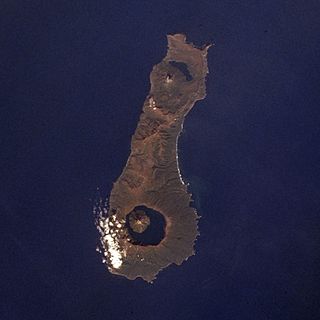
Tao-Rusyr Caldera is a stratovolcano located at the southern end of Onekotan Island, Kuril Islands, Russia. It has 7.5 km wide caldera formed during a catastrophic eruption less than 10,000 years ago. The waters of Kol'tsevoe Lake fill the caldera, along with a large symmetrical andesitic cone, Krenitsyn Peak, that rises as an island within the lake. This volcano was named after Captain Pyotr Krenitsyn of the Imperial Russian Navy.

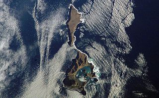
Moekeshiwan, also known as Lvinaya Past, is a volcano in the southern part of Iturup in the Kuril Islands, claimed by Japan and administered by Russia. The volcano is characterized by a large caldera that is flooded by the Sea of Okhotsk. A large eruption occurred early during the Holocene which reached a volcanic explosivity index of 7.

Rasshua is an uninhabited volcanic island near the center of the Kuril Islands chain in the Sea of Okhotsk in the northwest Pacific Ocean, 16 kilometres (9.9 mi) from Ushishir and 30 kilometres (19 mi) southwest of Matua. Its name is derived from the Ainu language for “fur coat”, "Rushu o a" (ルシュ・オ・ア), or "abundant furs", "Rushi o a" (ルシ・オ・ア).
Ushishir is a collective name for two uninhabited volcanic islands and several reefs, all being parts of an eponymous partially submerged volcano, located in the centre of the Kuril Islands chain in the Sea of Okhotsk in the northwest Pacific Ocean. Its name is derived from the Ainu language for "hot spring".

Kuntomintar is a Pleistocene andesitic stratovolcano located at the southern end of Shiashkotan Island, Kuril Islands, Russia. Kumtomintar is a high point on a small volcanic ridge with mellow slopes on all side except the north west side. The mountain is home to many steep drainages, waterfalls, and some small ponds. The volcano consists of a central cone that fills a 4-4.5 km caldera and its crater is at 1280 feet, is below the main peak, on the north west side, some periods of time hot water drains from the crater into the ocean via creek. A second caldera is situated on the west side and is breached to the west.
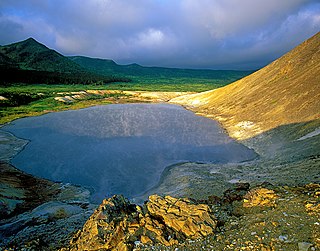
Kurils Nature Reserve is a Russian 'zapovednik' covering the north and south portions of Kunashir Island, the largest and most southernmost of the Kuril Islands, which stretch between Hokkaido Island in Japan to the Kamchatka peninsula in the Russia Far East. It also covers two smaller islands nearby to the southeast. The area is one of the largest wintering sites for coastal seabirds. The reserve sits on a tectonically unstable location, and is one of two Russian national reserves that protects territory of active volcanoes. The reserve is situated in the Yuzhno-Kurilsky District of Sakhalin Oblast. The reserve was created in 1984, and covers an area of 65,364 ha (252.37 sq mi).