Volcanic island

Last updated
Mo'orea, a volcanic island where the central island is still prominent Moorea ISS006.jpg
Mo'orea, a volcanic island where the central island is still prominent
Stromboli is one of the eight Aeolian Islands, a volcanic arc north of Sicily Aerial image of Stromboli (view from the northeast).jpg
Stromboli is one of the eight Aeolian Islands, a volcanic arc north of Sicily

Geologically, a volcanic island is an island of volcanic origin. The term high island can be used to distinguish such islands from low islands, which are formed from sedimentation or the uplifting of coral reefs (which have often formed on sunken volcanos). [1]

Contents

Definition and origin

There are a number of volcanic islands that rise no more than 1 metre (3 ft 3 in) above sea level, often classified as islets or rocks, while some low islands, such as Banaba, Henderson Island, Makatea, Nauru, and Niue, rise over 50 metres (160 ft) above sea level.

The two types of islands are often found in proximity to each other, especially among the islands of the South Pacific Ocean, where low islands are found on the fringing reefs that surround most volcanic islands. Volcanic islands normally rise above a hotspot.

Habitability

Volcanic islands usually range in size between 1 and 104 square kilometres (0.4 and 40 sq mi). [2] Islands above a certain size usually have fresh groundwater, while low islands often do not, so volcanic islands are more likely to be habitable.

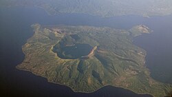
Many volcanic islands emerge from the deep abyss of the ocean, and feature rough or mountainous landscapes in their interiors and a diverse array of summit elevations. Researchers have observed that the island will often be covered by dense tropical forest. These limit settlement on the interior of many islands, forcing communities to develop along the coast. [3] Larger islands may have rivers, resulting in flood hazards. Rivers deliver sediment downstream, which can dominate the shape of the coast and contribute to erosion. Tall volcanic islands are often surrounded by protective fringing or barrier reefs, creating lagoons. [3]

The unique geological and geographical characteristics of volcanic islands make them prone to many natural hazards, which are expected to worsen due to climate change. These include volcanic eruptions, earthquakes, tsunamis, landslides, and severe weather events like hurricanes or typhoons. Studies have highlighted the importance of implementing effective risk mitigation plans that include nature-based solutions to improve societal safety on these islands. These involve leveraging natural processes and ecosystems to reduce hazard impacts. This can include the restoration of natural barriers like mangroves or coral reefs that protect against tsunamis and storm surges or the maintenance of natural water catchments that can mitigate flood risks. [4]

See also

Related Research Articles

<span class="mw-page-title-main">Geography of Palau</span>

The Republic of Palau consists of eight principal islands and more than 250 smaller ones lying roughly 500 miles southeast of the Philippines, in Oceania. The islands of Palau constitute the westernmost part of the Caroline Islands chain. The country includes the World War II battleground of Peleliu and world-famous rock islands. The total land area is 459 km2 (177 sq mi). It has the 42nd largest Exclusive Economic Zone of 603,978 km2 (233,197 sq mi).

<span class="mw-page-title-main">Geography of the Solomon Islands</span>

Solomon Islands is an island country in the South Pacific Ocean, that lies east of Papua New Guinea.

<span class="mw-page-title-main">Geography of Tonga</span>

Located in Oceania, Tonga is a small archipelago in the South Pacific Ocean, directly south of Samoa and about two-thirds of the way from Hawaii to New Zealand. It has 169 islands, 36 of them inhabited, which are in three main groups – Vavaʻu, Haʻapai, and Tongatapu – and cover an 800-kilometre (500-mile)-long north–south line. The total size is just 747 km2 (288 sq mi). Due to the spread out islands it has the 40th largest Exclusive Economic Zone of 659,558 km2 (254,657 sq mi).

<span class="mw-page-title-main">Tsunami</span> Series of water waves caused by the displacement of a large volume of a body of water

A tsunami is a series of waves in a water body caused by the displacement of a large volume of water, generally in an ocean or a large lake. Earthquakes, volcanic eruptions and other underwater explosions above or below water all have the potential to generate a tsunami. Unlike normal ocean waves, which are generated by wind, or tides, which are in turn generated by the gravitational pull of the Moon and the Sun, a tsunami is generated by the displacement of water from a large event.

<span class="mw-page-title-main">Atoll</span> Ring-shaped coral reef

An atoll is a ring-shaped island, including a coral rim that encircles a lagoon. There may be coral islands or cays on the rim. Atolls are located in warm tropical or subtropical parts of the oceans and seas where corals can develop. Most of the approximately 440 atolls in the world are in the Pacific Ocean.

<span class="mw-page-title-main">Natural disaster</span> Major adverse event resulting from natural processes of the Earth

A natural disaster is the highly harmful impact on a society or community following a natural hazard event. Some examples of natural hazard events include: flooding, drought, earthquake, tropical cyclone, lightning, tsunami, volcanic activity, wildfire. A natural disaster can cause loss of life or damage property, and typically leaves economic damage in its wake. The severity of the damage depends on the affected population's resilience and on the infrastructure available. Scholars have been saying that the term natural disaster is unsuitable and should be abandoned. Instead, the simpler term disaster could be used, while also specifying the category of hazard. A disaster is a result of a natural or human-made hazard impacting a vulnerable community. It is the combination of the hazard along with exposure of a vulnerable society that results in a disaster.

<span class="mw-page-title-main">Hawaiian Islands</span> Archipelago in the Pacific Ocean

The Hawaiian Islands are an archipelago of eight major volcanic islands, several atolls, and numerous smaller islets in the North Pacific Ocean, extending some 1,500 miles from the island of Hawaiʻi in the south to northernmost Kure Atoll. Formerly called the Sandwich Islands, the present name for the archipelago is derived from the name of its largest island, Hawaiʻi.

Landforms are categorized by characteristic physical attributes such as their creating process, shape, elevation, slope, orientation, rock exposure, and soil type.

<span class="mw-page-title-main">Mascarene Islands</span> Group of islands in the Indian Ocean

The Mascarene Islands or Mascarenes or Mascarenhas Archipelago is a group of islands in the Indian Ocean east of Madagascar consisting of the islands belonging to the Republic of Mauritius as well as the French department of La Réunion. Their name derives from the Portuguese navigator Pedro Mascarenhas, who first visited them in April 1512. The islands share a common geologic origin in the volcanism of the Réunion hotspot beneath the Mascarene Plateau and form a distinct ecoregion with a unique flora and fauna.

<span class="mw-page-title-main">National Park of American Samoa</span> United States national park in American Samoa

The National Park of American Samoa is a national park in the United States territory of American Samoa, distributed across four islands: Tutuila, Ofu, Olosega, and Ta‘ū. The park preserves and protects coral reefs, tropical rainforests, fruit bats, and the Samoan culture. Popular activities include hiking and snorkeling. Of the park's 8,257 acres (3,341 ha), 2,500 acres (1,000 ha) is coral reefs and ocean. The park is the only American National Park Service system unit south of the equator.

<span class="mw-page-title-main">Geological hazard</span> Geological state that may lead to widespread damage or risk

A geologic hazard or geohazard is an adverse geologic condition capable of causing widespread damage or loss of property and life. These hazards are geological and environmental conditions and involve long-term or short-term geological processes. Geohazards can be relatively small features, but they can also attain huge dimensions and affect local and regional socio-economics to a large extent.

The Hawaiian Trough, otherwise known as the Hawaiian Deep, is a moat-like depression of the seafloor surrounding the Hawaiian Islands. The weight from the volcanic island chain depresses the plastic lithosphere that is already weakened by the underlying thermal hotspot, causing subsidence to occur. The location with the greatest rate of subsidence is directly above the hotspot with a rate of about 0.1 inches per year. The Hawaiian Trough is about 18,045 feet deep and has a radius of about 8.7 miles (14.0 km). The subsiding lithosphere is balanced out and through the concept of isostasy a part of the crust surrounding the trough is levered upwards creating the Hawaiian Arch. The Hawaiian Arch extends about 656 feet above the surrounding ocean floor, and contains tilted coral reefs.

<span class="mw-page-title-main">Coral island</span> Island formed from coral and associated material

A coral island is a type of island formed from coral detritus and associated organic material. It occurs in tropical and sub-tropical areas, typically as part of a coral reef which has grown to cover a far larger area under the sea. The term low island can be used to distinguish such islands from high islands, which are formed through volcanic action. Low islands are formed as a result of sedimentation upon a coral reef or of the uplifting of such islands.

<span class="mw-page-title-main">Hawaii hotspot</span> Volcanic hotspot near the Hawaiian Islands, in the Pacific Ocean

The Hawaiʻi hotspot is a volcanic hotspot located near the namesake Hawaiian Islands, in the northern Pacific Ocean. One of the best known and intensively studied hotspots in the world, the Hawaii plume is responsible for the creation of the Hawaiian–Emperor seamount chain, a 6,200-kilometer (3,900 mi) mostly undersea volcanic mountain range. Four of these volcanoes are active, two are dormant; more than 123 are extinct, most now preserved as atolls or seamounts. The chain extends from south of the island of Hawaiʻi to the edge of the Aleutian Trench, near the eastern coast of Russia.

<span class="mw-page-title-main">Submarine landslide</span> Landslides that transport sediment across the continental shelf and into the deep ocean

Submarine landslides are marine landslides that transport sediment across the continental shelf and into the deep ocean. A submarine landslide is initiated when the downwards driving stress exceeds the resisting stress of the seafloor slope material, causing movements along one or more concave to planar rupture surfaces. Submarine landslides take place in a variety of different settings, including planes as low as 1°, and can cause significant damage to both life and property. Recent advances have been made in understanding the nature and processes of submarine landslides through the use of sidescan sonar and other seafloor mapping technology.

<span class="mw-page-title-main">Marianas Trench Marine National Monument</span> US national monument in the Mariana Archipelago

The Marianas Trench Marine National Monument is a United States National Monument created by President George W. Bush by the presidential proclamation no. 8335 on January 6, 2009. The monument includes no dry land area, but protects 95,216 square miles (246,610 km2) of submerged lands and waters in various places in the Mariana Archipelago. The United States could create this monument under international law because the maritime exclusive economic zones of the adjacent Northern Mariana Islands and Guam fall within its jurisdiction.

A tsunami is a series of water waves caused by the displacement of a large volume within a body of water, often caused by earthquakes, or similar events. This may occur in lakes as well as oceans, presenting threats to both fishermen and shoreside inhabitants. Because they are generated by a near field source region, tsunamis generated in lakes and reservoirs result in a decreased amount of warning time.

<span class="mw-page-title-main">Coastal hazards</span>

Coastal hazards are physical phenomena that expose a coastal area to the risk of property damage, loss of life, and environmental degradation. Rapid-onset hazards last a few minutes to several days and encompass significant cyclones accompanied by high-speed winds, waves, and surges or tsunamis created by submarine (undersea) earthquakes and landslides. Slow-onset hazards, such as erosion and gradual inundation, develop incrementally over extended periods.

<span class="mw-page-title-main">Rowa Islands</span> Group of islands in Vanuatu

Rowa Islands are an uninhabited archipelago in Torba Province of Vanuatu in the Pacific Ocean. The Rowa are a part of larger Banks Islands archipelago. The islands are a natural border between Melanesia and Polynesia; they are one of the most beautiful places in the South Pacific Ocean and an integral part of a vast system of atolls and reefs.

<span class="mw-page-title-main">Cumbre Vieja tsunami hazard</span> Review of the topic

The island of La Palma in the Canary Islands is at risk of undergoing a large landslide, which could cause a tsunami in the Atlantic Ocean. Volcanic islands and volcanoes on land frequently undergo large landslides/collapses, which have been documented in Hawaii for example. A recent example is Anak Krakatau, which collapsed to cause the 2018 Sunda Strait tsunami.

References

  1. Murphy, Raymond E. (July 1949). ""High" and "Low" Islands in the Eastern Carolines". Geographical Review . 39 (3). American Geographical Society: 425–439. Bibcode:1949GeoRv..39..425M. doi:10.2307/210643. JSTOR   210643.
  2. Condie, Kent C. (2022-01-01), Condie, Kent C. (ed.), "Chapter 2 – The crust", Earth as an Evolving Planetary System (Fourth Edition), Academic Press, pp. 9–37, ISBN   978-0-12-819914-5 , retrieved 2023-12-28
  3. 1 2 Velmurugan, Ayyam (2008-01-01), Sivaperuman, Chandrakasan; Velmurugan, Ayyam; Singh, Awnindra Kumar; Jaisankar, Iyyappan (eds.), "Chapter 1 – The Nature and Characters of Tropical Islands", Biodiversity and Climate Change Adaptation in Tropical Islands, Academic Press, pp. 3–30, ISBN   978-0-12-813064-3 , retrieved 2023-12-28
  4. López-Saavedra, Marta; Martí, Joan; Planagumà, Llorenç (2023). "How Effective Risk Assessment and Management Is the Key to Turning Volcanic Islands into a Source of Nature-Based Solutions". Land. 12 (3): 686. doi: 10.3390/land12030686 . ISSN   2073-445X.