Volcanic plug

Last updated
An aerial view of the Gros Piton and Petit Piton, in St. Lucia, 2006. Pitonpair.JPG
An aerial view of the Gros Piton and Petit Piton, in St. Lucia, 2006.

A volcanic plug, also called a volcanic neck or lava neck, is a volcanic object created when magma hardens within a vent on an active volcano. When present, a plug can cause an extreme build-up of high gas pressure if rising volatile-charged magma is trapped beneath it, and this can sometimes lead to an explosive eruption. In a plinian eruption the plug is destroyed and ash is ejected. [1]

Contents

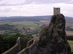
Glacial erosion can lead to exposure of the plug on one side, while a long slope of material remains on the opposite side. Such landforms are called crag and tail. If a plug is preserved, erosion may remove the surrounding rock while the erosion-resistant plug remains, producing a distinctive upstanding landform.

Examples of volcanic plugs

Volcanic plug near Rhumsiki, Cameroon. Rhumsiki Peak.jpg
Volcanic plug near Rhumsiki, Cameroon.

Africa

Near the village of Rhumsiki in the Far North Province of Cameroon, Kapsiki Peak is an example of a volcanic plug and is one of the most photographed parts of the Mandara Mountains. Spectacular volcanic plugs are present in the center of La Gomera island in the Canary Islands archipelago, within the Garajonay National Park.

Roque Bentayga from the town of Artenara Roque Bentayga visto desde Artenara.jpg
Roque Bentayga from the town of Artenara

Europe

Saint Michel d'Aiguilhe chapel, on top of a volcanic plug in Le Puy-en-Velay, France. Rocher St Michel a Aiguilhe.JPG
Saint Michel d'Aiguilhe chapel, on top of a volcanic plug in Le Puy-en-Velay, France.

Borgarvirki is a volcanic plug located in north Iceland.

A volcanic plug is situated in the town of Motta Sant'Anastasia in Italy.

Saint Michel d'Aiguilhe chapel, whose construction started in 969, [2] near Le Puy-en-Velay in France. The volcanic plug rises about 85 metres (279 ft) above the surroundings. Another building on a volcanic plug is the 14th century Trosky Castle in the Czech Republic. Strombolicchio, the northernmost of the Aeolian Islands, and Rockall, a small, uninhabited, remote islet in the North Atlantic Ocean, are also volcanic plugs.

In the United Kingdom, two examples of a building on a volcanic plug are the Castle Rock in Edinburgh, Scotland, and Deganwy Castle, Wales. The Law, Dundee, Ailsa Craig, Bass Rock, North Berwick Law and Dumgoyne hill are other examples of volcanic plugs located in Scotland. There are over 30 volcanic plugs in Northern Ireland, including Slemish in Ballymena, Tievebulliagh, Scawt Hill, Carrickarede, Scrabo and Slieve Gallion. [3]

North America and the Caribbean

There are several volcanic plugs in the United States, including Morro Rock in California, Devils Elbow located in the Heceta Head Lighthouse Scenic State Park on the Oregon coast, Thumb Butte in the Sierra Prieta of Arizona, and Shiprock in New Mexico. Devils Tower in Wyoming and Little Devils Postpile in Yosemite National Park, California, are also believed, by many geologists, to be volcanic plugs. In Canada, the Northern Cordilleran Volcanic Province gives rise to several confirmed and suspected plugs. Chief among these is Castle Rock, located in British Columbia, which last erupted during the Pleistocene. The southern coast of Saint Lucia is dominated by the iconic Pitons, a UNESCO World Heritage Site. The twin peaks, Gros Piton and Petit Piton, steeply rise more than 770 metres (2,530 ft) above the Caribbean.

South America

Pinnacle Rock, Galápagos, Ecuador.

Oceania

There are several volcanic plugs in the North Island of New Zealand, including:

In New Zealand's South Island, Onawe Peninsula on Banks Peninsula is a prominent volcanic plug, and erosion of Saddle Hill near Dunedin has also revealed a plug. Dunedin's Mount Cargill displays two plugs: its main summit and the subsidiary summit of Buttar's Peak.

In Australia, The Nut in Tasmania are further examples, along with Mount Warning and the several peaks in the Warrumbungles in New South Wales. The 11 peaks of the Glasshouse Mountains National Park including Mount Beerwah, Mount Tibrogargan, Mount Coonowrin, Mount Cooroora, Mount Ngungun, Mount Tibberoowuccum, Mount Tunbubudla, and Mount Beerburrum, in South East Queensland are volcanic plugs. [4] [5]

Related Research Articles

A caldera is a large cauldron-like hollow that forms shortly after the emptying of a magma chamber in a volcano eruption. An eruption that ejects large volumes of magma over a short period of time can cause significant detriment to the structural integrity of such a chamber, greatly diminishing its capacity to support its own roof, and any substrate or rock resting above. The ground surface then collapses into the emptied or partially emptied magma chamber, leaving a large depression at the surface. Although sometimes described as a crater, the feature is actually a type of sinkhole, as it is formed through subsidence and collapse rather than an explosion or impact. Compared to the thousands of volcanic eruptions that occur over the course of a century, the formation of a caldera is a rare event, occurring only a few times within a given window of 100 years. Only seven caldera-forming collapses are known to have occurred between 1911 and 2016. More recently, a caldera collapse occurred at Kīlauea, Hawaii in 2018.

<span class="mw-page-title-main">Inselberg</span> Isolated, steep rock hill on relatively flat terrain

An inselberg or monadnock is an isolated rock hill, knob, ridge, or small mountain that rises abruptly from a gently sloping or virtually level surrounding plain. In Southern Africa a similar formation of granite is known as a koppie, an Afrikaans word from the Dutch diminutive word kopje. If the inselberg is dome-shaped and formed from granite or gneiss, it can also be called a bornhardt, though not all bornhardts are inselbergs. An inselberg results when a body of rock resistant to erosion, such as granite, occurring within a body of softer rocks, is exposed by differential erosion and lowering of the surrounding landscape.

Landforms are categorized by characteristic physical attributes such as their creating process, shape, elevation, slope, orientation, rock exposure, and soil type.

<span class="mw-page-title-main">Stromboli</span> Active volcanic island off the coast of Sicily, Italy

Stromboli is an island in the Tyrrhenian Sea, off the north coast of Sicily, containing Mount Stromboli, one of the four active volcanoes in Italy. It is one of the seven Aeolian Islands, a volcanic arc north of Sicily. Strabo writes that people believed that this is where Aeolus lived.

<span class="mw-page-title-main">Butte</span> Isolated hill with steep, often vertical sides and a small, relatively flat top

In geomorphology, a butte is an isolated hill with steep, often vertical sides and a small, relatively flat top; buttes are smaller landforms than mesas, plateaus, and tablelands. The word butte comes from the French word butte, meaning knoll ; its use is prevalent in the Western United States, including the southwest where mesa is used for the larger landform. Due to their distinctive shapes, buttes are frequently landmarks in plains and mountainous areas. To differentiate the two landforms, geographers use the rule of thumb that a mesa has a top that is wider than its height, while a butte has a top that is narrower than its height.

<span class="mw-page-title-main">Plateau</span> Highland area, usually of relatively flat terrain

In geology and physical geography, a plateau, also called a high plain or a tableland, is an area of a highland consisting of flat terrain that is raised sharply above the surrounding area on at least one side. Often one or more sides have deep hills or escarpments. Plateaus can be formed by a number of processes, including upwelling of volcanic magma, extrusion of lava, and erosion by water and glaciers. Plateaus are classified according to their surrounding environment as intermontane, piedmont, or continental. A few plateaus may have a small flat top while others have wider ones.

<span class="mw-page-title-main">Cirque</span> An amphitheatre-like valley formed by glacial erosion

A cirque is an amphitheatre-like valley formed by glacial erosion. Alternative names for this landform are corrie and cwm. A cirque may also be a similarly shaped landform arising from fluvial erosion.

<span class="mw-page-title-main">Maar</span> Low-relief volcanic crater

A maar is a broad, low-relief volcanic crater caused by a phreatomagmatic eruption. A maar characteristically fills with water to form a relatively shallow crater lake, which may also be called a maar.

<span class="mw-page-title-main">Shiprock</span> Monadnock in San Juan County, New Mexico

Shiprock is a monadnock rising nearly 1,583 feet (482 m) above the high-desert plain of the Navajo Nation in San Juan County, New Mexico, United States. Its peak elevation is 7,177 feet (2,188 m) above sea level. It is 10.75 miles (17.30 km) southwest of the town of Shiprock, which is named for the peak.

<span class="mw-page-title-main">Somma volcano</span> Volcanic caldera that has been partially filled by a new central cone

A somma volcano, also known as a sommian, is a volcanic caldera that has been partially filled by a new central cone. The type is named after Mount Somma ("Summit"), a stratovolcano in southern Italy with a summit caldera in which the upper cone of Mount Vesuvius has grown. Other examples of somma volcanoes can be found on Russia's Kamchatka Peninsula and the Kuril Islands, stretching south from Kamchatka to Hokkaidō, Japan.

<span class="mw-page-title-main">Volcanism of New Zealand</span> Volcanic activity of New Zealand

The volcanism of New Zealand has been responsible for many of the country's geographical features, especially in the North Island and the country's outlying islands.

<span class="mw-page-title-main">Pilot Rock (Oregon)</span> Mountain in Oregon, USA

Pilot Rock is a prominent volcanic plug located in the western Cascade Range near the east end of the Siskiyou Mountains, just east of the Siskiyou Summit near Ashland, Oregon. Rising thousands of feet above the Shasta and Rogue valleys, it is a landmark distinguishable from over 40 miles (64 km) away. At 25.6 million years old, it is one of the oldest formations of the Cascade Range. The rock is protected by the Cascade–Siskiyou National Monument and the Soda Mountain Wilderness. Several trails pass near Pilot Rock, including the Pacific Crest Trail.

The Neck is a mountain in northwestern British Columbia, Canada, located in Mount Edziza Provincial Park. It is a volcanic feature of the Northern Cordilleran Volcanic Province that formed in the past 1.6 million years of the Pleistocene epoch.

<span class="mw-page-title-main">Geology of the Auckland Region</span>

The Auckland Region of New Zealand is built on a basement of greywacke rocks that form many of the islands in the Hauraki Gulf, the Hunua Ranges, and land south of Port Waikato. The Waitākere Ranges in the west are the remains of a large andesitic volcano, and Great Barrier Island was formed by the northern end of the Coromandel Volcanic Zone. The Auckland isthmus and North Shore are composed of Waitemata sandstone and mudstone, and portions of the Northland Allochthon extend as far south as Albany. Little Barrier Island was formed by a relatively isolated andesitic volcano, active around 1 to 3 million years ago.

<span class="mw-page-title-main">Geology of the Northland Region</span>

New Zealand's Northland Region is built upon a basement consisting mainly of greywacke rocks, which are exposed on the eastern side of the peninsula. In-place Eocene coal measures crop out at Kamo, near Whangarei, and Oligocene limestone crops out at Hikurangi, near Whangarei.

<span class="mw-page-title-main">Dunedin Volcano</span> An extinct volcano in South Island, New Zealand

The Dunedin Volcano is an extensively eroded multi-vent shield volcano that was active between 16 and 10 million years ago. It originally extended from the modern city of Dunedin, New Zealand to Aramoana about 25 km away. Extensive erosion has occurred over the last 10 million years and Otago Harbour now fills the oldest parts of the volcano. The remnants of the volcano form the hills around Otago Harbour.

<span class="mw-page-title-main">Scawt Hill</span> Mountain in Northern Ireland

Scawt Hill is a volcanic plug in County Antrim, Northern Ireland, in the borough of Larne, 5 km from the village of Ballygally.

<span class="mw-page-title-main">Surface features of Venus</span>

The surface of Venus is dominated by geologic features that include volcanoes, large impact craters, and aeolian erosion and sedimentation landforms. Venus has a topography reflecting its single, strong crustal plate, with a unimodal elevation distribution that preserves geologic structures for long periods of time. Studies of the Venusian surface are based on imaging, radar, and altimetry data collected from several exploratory space probes, particularly Magellan, since 1961. Despite its similarities to Earth in size, mass, density, and possibly composition, Venus has a unique geology that is unlike Earth's. Although much older than Earth's, the surface of Venus is relatively young compared to other terrestrial planets, possibly due to a global-scale resurfacing event that buried much of the previous rock record. Venus is believed to have approximately the same bulk elemental composition as Earth, due to the physical similarities, but the exact composition is unknown. The surface conditions on Venus are more extreme than on Earth, with temperatures ranging from 453 to 473 °C and pressures of 95 bar. Venus lacks water, which makes crustal rock stronger and helps preserve surface features. The features observed provide evidence for the geological processes at work. Twenty feature types have been categorized thus far. These classes include local features, such as craters, coronae, and undae, as well as regional-scale features, such as planitiae, plana, and tesserae.

<span class="mw-page-title-main">Banks Peninsula Volcano</span> An extinct volcano in New Zealand

The Banks Peninsula Volcano is an extinct volcanic complex to the east of Christchurch on New Zealand's South Island. While the volcano is highly eroded it still forms the majority of Banks Peninsula with a highest point of 919 m (3,015 ft). It is a composite of two main eruptive centres one originating at Lyttelton Harbour, the other at Akaroa Harbour. The eruptions were predominantly basaltic, with associated andesite and trachytes, with minor rhyolite. The volcanic activity occurred in the Late Miocene and possibly extended into the Early Pliocene. There are four volcanic groups, all of which are within the Māui Supergroup. The Christchurch earthquakes led to rumors of a possible eruption, however, there is no known magma chamber beneath the volcano and there has not been any sign of volcanic activity in the last 5 million years.

References

  1. Huff, W.D.; Owen, L.A. (2013). "Volcanic Landforms and Hazards". Treatise on Geomorphology. 5: 155. doi:10.1016/B978-0-12-374739-6.00089-0. ISBN   9780080885223.
  2. Base Mérimée : Eglise Saint-Michel , Ministère français de la Culture. (in French)
  3. Wilson, H E et al (1986) Geological Survey of Northern Ireland, HMSO
  4. "Guide to the Glass House Mountains – Tourism Australia". 21 July 2021.
  5. "Wollumbin/Mt Warning Shield Volcano". Geological sites of NSW. Cartoscope Pty Limited. Retrieved 30 June 2013.