
Burleigh Head is a small national park at Burleigh Heads in the City of Gold Coast in South East Queensland, Australia.
Glass House Mountains National Park is a heritage-listed national park at Glass House Mountains, Sunshine Coast Region, Queensland, Australia. It is also known as Beerburrum Forest Reserve 1. It is 70 km (43 mi) north of Brisbane and consists of a flat plain punctuated by rhyolite and trachyte volcanic plugs, the cores of extinct volcanoes that formed 26 million to 27 million years ago. The mountains would once have had pyroclastic exteriors, but these have eroded away.

The Lamington National Park is a national park, lying on the Lamington Plateau of the McPherson Range on the Queensland/New South Wales border in Australia. From Southport on the Gold Coast the park is 85 kilometres (53 mi) to the southwest and Brisbane is 110 kilometres (68 mi) north. The 20,600 hectares Lamington National Park is known for its natural environment, rainforests, birdlife, ancient trees, waterfalls, walking tracks and mountain views. The park protects parts of the Eastern Australian temperate forests.

Mount Coolum is a hill in Mount Coolum National Park in a suburb of the same name in Queensland, Australia. Mount Coolum is located on the Sunshine Coast, 101 km north of Brisbane. It lies between the Sunshine Motorway to the west, the shoreline to the east, Coolum Beach township to the north and Marcoola township to the south.
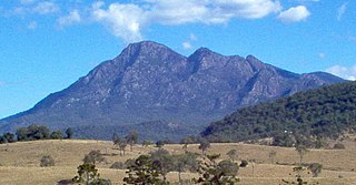
Mount Barney is a mountain within the Scenic Rim Region in south-east Queensland, Australia. It lies approximately 130 kilometres (81 mi) south-west of Brisbane, not far from the Queensland - New South Wales border, and forms part of the McPherson Range. It is a popular destination for bushwalkers and campers. Mount Barney is the sixth or seventh highest mountain in Queensland and is often regarded as one of the most impressive parts of the Scenic Rim. The mountain consists of two main peaks,, and smaller subsidiary peaks. East Peak is probably the most popular destination for bushwalkers.
Mount Lindesay is a rural locality in the Scenic Rim Region, Queensland, Australia. It borders New South Wales. In the 2016 census, Mount Lindesay had a population of 3 people.

A volcanic plug, also called a volcanic neck or lava neck, is a volcanic object created when magma hardens within a vent on an active volcano. When present, a plug can cause an extreme build-up of high gas pressure if rising volatile-charged magma is trapped beneath it, and this can sometimes lead to an explosive eruption. In a plinian eruption the plug is destroyed and ash is ejected.

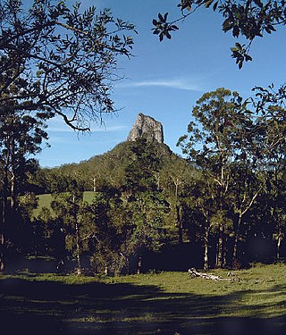
Mount Beerwah is the highest of the ten volcanic plugs in the Glass House Mountains range, 22 kilometres (14 mi) north of Caboolture in South East Queensland, Australia. It was formed 26 million years ago during the Oligocene Epoch of the Paleogene Period. Geologists estimate it may be only a third of its original height due to intense erosion.
Glass House Mountains is a rural hinterland town and locality in the Sunshine Coast Region, Queensland, Australia. In the 2016 census, the locality of Glass House Mountains had a population of 5,065 people.
The D'Aguilar Range is a mountain range near Brisbane, Queensland, Australia. The town of Dayboro is situated on the lower foothills midway along the range and the Sunshine Coast Hinterland town of Mooloolah lies at the northernmost point of the range. Many residential areas line its eastern slopes including the town of Samford and the suburb of Ferny Hills. In the west, numerous ridges and gullies are heavily forested and designated as state forest or national park.

Glasshouse Mountains railway station is located on the North Coast line in Queensland, Australia. It serves the town of Glass House Mountains in the Sunshine Coast Region.

Landsborough is a town and a locality in the Sunshine Coast Region, Queensland, Australia. At the 2021 census, Landsborough had a population of 4,446 people.
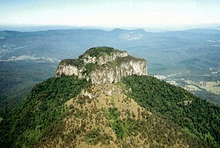
Coonowrin is one of the Glass House Mountains, located in Queensland, Australia, located 19 km north of Caboolture or about one hour's drive north of Brisbane. It is easily distinguished because of its rocky formation at the top. It is also known by its unofficial name Crookneck.

Beerwah is a rural town and locality in the hinterland of the Sunshine Coast Region, Queensland, Australia. At the 2021 census, the locality of Beerwah had a population of 7,734 people.

The Glass House Mountains are a cluster of thirteen hills that rise abruptly from the coastal plain on the Sunshine Coast, Queensland, Australia. The highest hill is Mount Beerwah at 556 metres above sea level, but the most identifiable of all the hills is Mount Tibrogargan which from certain angles bears a resemblance to a gorilla facing east towards the ocean. The Glass House Mountains are located near Beerburrum State Forest and Steve Irwin Way. From Brisbane, the mountains can be reached by following the Bruce Highway north and taking the Glass House Mountains tourist drive turn-off onto Steve Irwin Way. The trip is about one hour from Brisbane. The Volcanic peaks of the Glass House Mountains rise dramatically from the surrounding Sunshine Coast landscape. They were formed by intrusive plugs, remnants of volcanic activity that occurred 26–27 million years ago. Molten rock filled small vents or intruded as bodies beneath the surface and solidified into land rocks. Millions of years of erosion have removed the surrounding exteriors of volcanic cores and softer sandstone rock.

Comendite is a hard, peralkaline igneous rock, a type of light blue grey rhyolite. Phenocrysts are sodic sanidine with minor albite and bipyramidal quartz. Comendite occurs in the mountains Tibrogargan, Coonowrin, Tunbubudla, Coochin, Saddleback, Tibberoowuccum and Ngungun in the Glass House Mountains, South East Queensland, Australia. The blue colour is caused by very small crystals of riebeckite or arfvedsonite. Comendite also occurs in Sardinia, Corsica, Ascension Island, Ethiopia, Somalia and other areas of East Africa. The 1903 eruption of Changbaishan volcano in north-east China erupted comendite pumice.
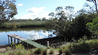
Coochin Creek is a coastal locality in the south of the Sunshine Coast Region, Queensland, Australia. The locality is named for the creek which flows through it.

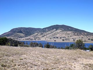
Mount Ngungun is the sixth tallest of the Glass House Mountains at 253 metres (830 ft). It has a well maintained walking trail to the summit that affords good views. The trail from carpark is not as steep as the higher mountains and is open to beginners. The south face contains steeper, unmarked but well known rock climbing routes. When viewed from Moreton Bay it lines up with and is silhouetted by Mount Beerwah and Mt Coonowrin/Crookneck. This was noted by Captain Cook on his first voyage of along the East coast of Australia. It is known as the dingo to the family of the rest of the Glasshouse Mountains.
Stanmore is a rural locality in the City of Moreton Bay, Queensland, Australia. In the 2021 census Stanmore had a population of 454 people.


