Gran Canaria, also Grand Canary Island, is the third-largest and second-most-populous island of the Canary Islands, an archipelago off the Atlantic coast of Northwest Africa and is part of Spain. As of 2023 the island had a population of 862,893 that constitutes approximately 40% of the population of the archipelago. Las Palmas de Gran Canaria, the capital of the island, is the biggest city of the Canary Islands and the ninth of Spain.

Mogán is a town and a Spanish municipality in the southwestern part of the island of Gran Canaria, which is one of the three main islands making up the Province of Las Palmas in the Canary Islands, Spain. Its population is 21,782 (2013), and the area is 172.44 km2.

Santa María de Guía de Gran Canaria is a town and a municipality in Las Palmas province of the Canary Islands. It is located on the north side of Gran Canaria island. Its population is 13,811 (2013), and the area is 42.59 km2 (16.44 sq mi).

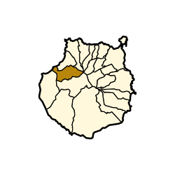
Agaete is a municipality of Las Palmas province, on the Canary Islands, Spain.

Firgas is a town and a municipality in the northern part of the island of Gran Canaria, in the Province of Las Palmas, in the Canary Islands. Its population is 7,628 (2013), and its area is 15.77 km². Firgas was founded in 1488, and it is situated in the mountains, 13 km west of Las Palmas. The town, which is located in a green and rural zone, is also known as the balcony of the Atlantic, as it provides good views of the northern coast of the island. Bottled water is produced in the town.

Santa Brígida is a municipality in the northeastern part of the island of Gran Canaria in the Province of Las Palmas of the Canary Islands. Its population is 18,791 (2013), and the area is 23.81 km2. It borders Las Palmas to the west and is part of its urban area.
Telde is a municipality in the eastern part of the island of Gran Canaria, Canary Islands, overseas (Atlantic) insular Spain. It borders Las Palmas to the north and is part of its urban area.

Vega de San Mateo is a town and a municipality in the mountainous central part of the island of Gran Canaria in the Province of Las Palmas in the Canary Islands. Its population is 7,774 (2013), and the area is 37.89 km2. Vega de San Mateo is located 17 km southwest of Las Palmas.

Valsequillo de Gran Canaria is a town and a municipality in the eastern part of the island of Gran Canaria in the Province of Las Palmas in the Canary Islands. Its population is 9,170 (2013), and the area is 39.15 km².

Ingenio is a town and a Spanish municipality in the eastern part of the island of Gran Canaria in the Province of Las Palmas in the Canary Islands. Its population is 29,978 (2013), and the area is 38.15 km2 (14.73 sq mi).

Agüimes is a Spanish town and municipality in the eastern part of the island of Gran Canaria in the Las Palmas province in the Canary Islands.

Santa Lucía de Tirajana is a town and a Spanish municipality in the south-eastern part of the island of Gran Canaria, in the Province of Las Palmas, in the Canary Islands.

San Bartolomé de Tirajana is a village and a Spanish municipality in the south-eastern part of the island of Gran Canaria in the Las Palmas province in the Canary Islands. With an area of 333.13 km2 (128.62 sq mi), San Bartolomé de Tirajana is the largest municipality in area on the island as well as the Canary Islands. The population is 56,698 (2013).

La Aldea de San Nicolás is the westernmost municipality of the island of Gran Canaria in the Las Palmas province of the Canary Islands. Its full name was, until 2005, La Aldea de San Nicolás de Tolentino, and the locals simply call it La Aldea. Its population is 8,228 (2013), and the area is 123.58 km2. Its elevation is about 33m.

Tejeda is a village and a municipality in the mountainous central part of the island of Gran Canaria in the province of Las Palmas in the Canary Islands.

Gáldar is a town and a Spanish municipality in the north of the island of Gran Canaria in the Province of Las Palmas in the Canary Islands. Its population is 24,227 (2013), and the area is 61.59 km2 (23.78 sq mi).

Moya is a town and a municipality in the northern part of the island of Gran Canaria in the Province of Las Palmas in the Canary Islands. Its population is 7,977 (2013), and the area is 31.87 km2.

Arucas is a municipality in the northern part of the island of Gran Canaria, province of Las Palmas, Canary Islands. Arucas borders Las Palmas to the west and is part of its urban area. Its population is 36,852 (2013), and the area is 33.01 km2 (12.75 sq mi). The GC-2 motorway passes north of the town.
Valle Gran Rey is a municipality in the western part of the island La Gomera, in the province of Santa Cruz de Tenerife of the Canary Islands, Spain. The Guanche name of the area was Orone. The seat of the municipality since 1930 is La Calera; previously it was in Arure.

Teror is a municipality in the northern part of the island of Gran Canaria in the Province of Las Palmas in the Canary Islands. Its population is 12,671 (2013), and the town area is 25.70 km2. Teror is situated in the mountains and borders Las Palmas to the west and is part of its urban area. September 8 is the local festivity celebrating Virgen del Pino.