The village of Tejeda is situated 6km (4mi) north-west of the Pico de las Nieves and 23km (14mi) south-west of the island capital Las Palmas.
Tejeda with Roque Nublo and Roque Bentayga
Geography
The municipality's area is 103.3km2 (39.9sqmi),[1] spreading near the centre of the island, on the latter's west side.
The south-eastern part of its territory includes the second highest point of Gran Canaria island, Pico de las Nieves ("Snows Peak") - 1,949m (6,394ft). Other remarkable summits in the municipality are Roque Nublo ("Cloud Rock") 813m (2,667ft) and Roque Bentayga ("Bentayga Rock") with its ritual place (almogarén) and other features. Close by are the cuevas del Rey ("the King's caves", 1km to the west of Rock Bentayga), an antique cave house village with granaries; and 2km further west the antique cave house village of Acusa Seca.[3] All these sites are listed Spanish Heritage as Properties of cultural interest ("Bien de Interés Cultural").[4]
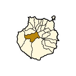
Geology: caldera de Tejeda
The caldera, drawing by Víctor Grau-Bassas
The village of Tejeda sits on the eastern edge[5] of a volcanic basin or crater that bears its name (caldera de Tejeda).[6][note 1][note 2]
The caldera’s dimensions are 28 km x 18 km, with a surface that extends from the head of Agaete's ravine (barranco de Agaete)[7] near Artenara, to Verde Andén ("Green Platform") in the west,[8] Veneguera[9] and the head of Mogán ravine (barranco de Mogán)[10] up to Arguineguín's ravine (barranco de Arguineguin).[11] Only half of its perimeter remains standing; on what is left of it are found a few green-bluish peaks (such as "azulejos" de Veneguera - "Veneguera's tiles") and below these are the oldest basalts of the island, primitive substrate of Grand Canary.[12]
The caldera was produced in probably less than two hours, by the explosion of the residual magma chambers[note 3] During the collapse of the caldera de Tejeraignimbrite rock was produced, with a pink matrix dotted with white crystals. It exists because the explosive eruption by which the caldera collapsed was so powerful that the magma was pulverized in a very fine spray and created almost microscopic structures in the matrix rock. Ignimbrita is found on the outside of the periphery of the caldera. The caldera also bears traces of a 2 million year period of evolution. This is especially notable at the heads of the Agaete ravine (barranco de Agaete) and Mogan ravine (barranco de Mogan), where we can see horizontal basaltic lavas in their lower parts and, above, thicker material in sloping layers.[12]
Another rare feature of the caldera is its system of conical dykes in its center, that were damaged by the eruptions and determined the structure of the island by their own structure. The lava passed through these dykes during some eruptions, in particular basaltic eruptions; this created a crack in the surrounding channels where the lava was injected, and from them the volcano arose. In Grand Canary these conical dykes were centered on a focal point located roughly 2km under sea level, at what was in the past the center of the island. New magma would then tend to also take the same conical shape. Conical dykes of this size are not found in other islands; Vallehermoso on La Gomera island has some smaller ones.[12]
Biologist Juan Sergio Socorro considers this crater to be one of the few clear examples in the world of a very large collapsed volcanic crater, particularly in comparison to the Cañadas del Teide for which several theories are held regarding its formation.[13][note 4]
"El espectáculo es imponente. Todas aquellas negras murallas de la gran caldera, con sus crestas, que parecen almenas, con sus roques enhiestos, ofrecen el aspecto de una visión dantesca. No otra cosa pueden ser las calderas del Infierno que visitó el florentino. Es una tremenda conmoción de las entrañas de la tierra; parece todo una tempestad petrificada, pero una tempestad de fuego, de lava, más que de agua." ("The spectacle is impressive. All those black walls of the great caldera, with its crests, which look like battlements, with its erect rocks, offer a Dantesque vision. The cauldrons of Hell that the Florentine visited can be no different. It is a tremendous commotion of the entrails of the earth; it looks quite like a petrified storm, but a storm of fire, of lava, more than of water.")
↑ (in Spanish)Gran Canaria - Origen y formación ("Grand Canary: origin and formation") on gevic.net. This page includes an evolutive diagram showing the main stages of formation and evolution of Gran Canaria island, with the resultant collapsed Tejeda crater.
↑ Residual magma chambers are the cavities that hold the magma that is not projected outside during an eruption. They usually lay 2 to 3 km underground. After an eruption the magma in the chamber slowly cools down, at the same time as heavy particles that it may contain, such as iron, fall at the bottom of the chamber – thus capping the hole by which magma comes out from the Earth’s mantle. When more magma is injected outwards from the mantle, that cap bursts under the pressure and the magma within the chamber violently erupts outward. The outer surface above the chamber then collapses.
↑ Formation of the Cañadas del Teide: the main alternative theory about their formation is that of a gravitational slide, which seems to be the most probable in regard of the scientific evidences.
This page is based on this Wikipedia article Text is available under the CC BY-SA 4.0 license; additional terms may apply. Images, videos and audio are available under their respective licenses.