Slemish

Last updated

Slemish
Sliabh Mis
Slemish (6) - geograph.org.uk - 624718.jpg
Highest point
Elevation 437 m (1,434 ft)
Prominence 150 m (490 ft)
Listing Marilyn
Coordinates 54°52′55″N6°5′49″W / 54.88194°N 6.09694°W / 54.88194; -6.09694
Naming
English translationMis' Mountain
Geography
Relief Map of Northern Ireland.png
Red triangle with thick white border.svg
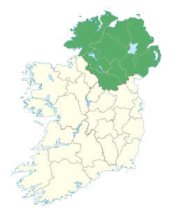
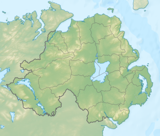
Slemish
Location in Northern Ireland
Location Antrim, Northern Ireland
Parent range Antrim Hills
OSI/OSNI grid D221054
Geology
Mountain type Volcanic plug

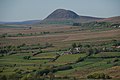
Slemish, historically called Slieve Mish [1] (from Irish : Sliabh Mis, meaning 'Mis's mountain'), [2] is a hill in County Antrim, Northern Ireland. It lies a few miles east of Ballymena, in the townland of Carnstroan. Tradition holds that Saint Patrick, enslaved as a youth, was brought to this area and tended sheep herds on Slemish, and that during this time he found God. [3]

Contents

Slemish is the remains of the plug of an extinct volcano. The plug is made of olivine dolerite [4] and was formed during the Palaeogene period of the Earth's geological history. [5] Its distinctive appearance —its upper reaches are very steep and rugged, in contrast to the tidy fields on its lower westward-facing slopes and the relatively flat bogland to the east— causes it to dominate the landscape for miles around.

Slemish is within an Environmentally Sensitive Area (ESA) and, therefore, helps to protect and manage the fragile animal and plant communities that inhabit its slopes. An ideal location for bird watchers, large black ravens, buzzards, wheatears and meadow pipits can be seen regularly.

History

Slemish Mountain is the legendary first known Irish home of Saint Patrick. [6] According to legend, following his capture and being brought to Ireland as a slave, Patrick worked as a shepherd at Slemish Mountain for about six years, [7] from ages 16 to 22, for a man named Milchu (or Miluic).

It was during this time that Patrick turned to frequent prayer as his only consolation in his loneliness. In a vision he was encouraged to escape and return home.

He did this, then became a priest and returned to Ireland, allegedly to convert his old master. The legend goes that his own real conversion took place while on Slemish out in all weathers, communing with nature and praying continuously. As Patrick was not the first Christian Bishop to visit Ireland, his ministry was confined to the North. Here he established churches and an episcopal system. One such church is thought to have been founded at the nearby site of Skerry Churchyard.

In later times, Slemish was the site of a United Irish camp during the 1798 rebellion in County Antrim.

Activities

Slemish Mountain is open year-round, and on Saint Patrick's Day (17 March) large crowds walk to the top of the mountain as a pilgrimage. The one and a half kilometre round walk to the summit and back takes approximately one hour in good weather. Excellent views can be had of the Antrim and Scottish coasts to the east. Ballymena town, Lough Neagh and the Sperrin Mountains are all normally visible to the west whilst the Bann Valley and the higher summits of the Antrim Hills can be seen to the North. The 180 metre climb is steep and rocky.

There is a parking facility with interpretation boards and washrooms on site.

Literature

Slemish features in Dennis Kennedy's book Climbing Slemish. The book chronicles the history of a family over a whole century of Northern Irish life. [8]

Annalistic references

See Annals of Inisfallen (AI)

Related Research Articles

<span class="mw-page-title-main">County Antrim</span> Historic Northern Ireland county

County Antrim is one of six counties of Northern Ireland and one of the thirty-two counties of Ireland. Adjoined to the north-east shore of Lough Neagh, the county covers an area of 3,086 square kilometres (1,192 sq mi) and has a population of 651,321, as of the 2021 census. County Antrim has a population density of 203 people per square kilometre or 526 people per square mile. It is also one of the thirty-two traditional counties of Ireland, as well as part of the historic province of Ulster.

<span class="mw-page-title-main">Ballymena</span> Town in County Antrim, Northern Ireland

Ballymena is a town in County Antrim, Northern Ireland. It had a population of 31,205 people at the 2021 Census, making it the seventh largest town in Northern Ireland by population. It is part of the Borough of Mid and East Antrim.

<span class="mw-page-title-main">Volcanic plug</span> Volcanic object created when magma hardens within a vent on an active volcano

A volcanic plug, also called a volcanic neck or lava neck, is a volcanic object created when magma hardens within a vent on an active volcano. When present, a plug can cause an extreme build-up of high gas pressure if rising volatile-charged magma is trapped beneath it, and this can sometimes lead to an explosive eruption. In a plinian eruption the plug is destroyed and ash is ejected.

<span class="mw-page-title-main">Henry Joy McCracken</span>

Henry Joy McCracken was an Irish republican, a leading member of the Society of the United Irishmen and a commander of their forces in the field in the Rebellion of 1798. In pursuit of an independent and democratic Irish republic, he sought to ally the disaffected Presbyterians organised in the Society with the Catholic Defenders, and in 1798 to lead their combined forces in Antrim against the British Crown. Following the defeat and dispersal of the rebels under his command, McCracken was court-martialled and executed in Belfast.

<span class="mw-page-title-main">Ballygally</span> Village in Northern Ireland

Ballygally or Ballygalley is a village and holiday resort in County Antrim, Northern Ireland which lies on the Antrim coast, approximately 3 miles north of Larne. It is also a townland of 769 acres and is situated in the civil parish of Carncastle and the historic barony of Glenarm Upper. It had a population of 821 in the 2011 Census. It is located within the Mid and East Antrim Borough Council area.

<span class="mw-page-title-main">Cullybackey</span> Village in County Antrim, Northern Ireland

Cullybackey or Cullybacky is a large village in County Antrim, Northern Ireland. It lies 3 miles north-west of Ballymena, on the banks of the River Main, and is part of Mid and East Antrim district. It had a population of 2,569 people in the 2011 Census.

<span class="mw-page-title-main">Dunloy</span> Village in County Antrim, Northern Ireland

Dunloy is a village and townland in County Antrim, Northern Ireland. It is located 11 miles (18 km) north of Ballymena and 6 miles (10 km) north-west is Ballymoney. It is located in the civil parish of Finvoy, in the former barony of Kilconway. The village had a population of 1,194 people in the 2011 Census.

Kells is a village near Ballymena in County Antrim, Northern Ireland, that also encompasses the neighbouring village of Connor. As such it is also known as Kells and Connor in which they share a primary school, library, development association etc. It is in Mid and East Antrim District Council. Kells and Connor had a population of 2,053 people in the 2011 Census.

<span class="mw-page-title-main">Scouting in Northern Ireland</span>

Scouting in Northern Ireland is represented by three Scouting associations. The Scouts NI is part of The Scout Association of the United Kingdom, which is the World Organization of the Scout Movement (WOSM) recognized Scouting association in the United Kingdom. Scouting Ireland is the national Scouting association and the WOSM-recognized Scouting association for the Republic of Ireland, although its membership extends to Northern Ireland. The Baden-Powell Scouts' Association is a member of the World Federation of Independent Scouts and operates one group in Northern Ireland.

<span class="mw-page-title-main">Dál nAraidi</span> Middle Ages Cruthin kingdom in Ireland

Dál nAraidi or Dál Araide, sometimes latinised as Dalaradia or anglicised as Dalaray, was a Cruthin kingdom, or possibly a confederation of Cruthin tribes, in north-eastern Ireland during the Middle Ages. It was part of the over-kingdom of Ulaid, and its kings often contended with the Dál Fiatach for the over-kingship of the province. At its greatest extent, the borders of Dál nAraidi roughly matched those of County Antrim, and they seemed to occupy the same area as the earlier Robogdii of Ptolemy's Geography, a region shared with Dál Riata. Their capital was Ráth Mór outside Antrim, and their eponymous ancestor is claimed as being Fiachu Araide.

<span class="mw-page-title-main">Cargan</span> Hamlet in County Antrim, Northern Ireland

Cargan is a hamlet and townland in County Antrim, Northern Ireland. It lies at the foot of Slievenanee in Glenravel – locally known as "The Tenth Glen" along with the more widely known nine Glens of Antrim. It is part of Mid and East Antrim district. It had a population of 588 people in the 2011 Census.

<span class="mw-page-title-main">Tievebulliagh</span>

Tievebulliagh is a 402-metre-high (1,319 ft) mountain in the Glens of Antrim, Northern Ireland. It forms part of the watershed between Glenaan to the north and Glenballyemon to the south. It is situated about 4.4 km from Cushendall.

All Saints Gaelic Athletic Club is the only Gaelic Athletic Association club in the town of Ballymena, County Antrim. The club is a member of the South-West Antrim division of Antrim GAA, and competes in Gaelic football, hurling, Ladies Gaelic football and camogie.

Buckna is a small village four miles east of Broughshane in County Antrim, Northern Ireland. It is part of Mid and East Antrim District Council and is close to Slemish mountain.

<span class="mw-page-title-main">Slemish College</span> Integrated secondary school in Ballymena, County Antrim, Northern Ireland

Slemish College is a co-educational integrated secondary school in Ballymena, Northern Ireland.

<span class="mw-page-title-main">Carnalbanagh</span> Village in County Antrim, Northern Ireland

Carnalbanagh is a small village and townland in County Antrim, Northern Ireland, 13 km east-north-east of Ballymena. It is situated in the civil parish of Tickmacrevan and the historic barony of Glenarm Lower, and is part of Mid and East Antrim district. It lies above Glenarm and is close to Mount Slemish.

<span class="mw-page-title-main">Scawt Hill</span>

Scawt Hill is a volcanic plug in County Antrim, Northern Ireland, in the borough of Larne, 5 km from the village of Ballygally.

Saint Columb's Rill is a tributary of the much more famous River Bush in Northern Ireland. This 'rill' or rivulet is really a small stream that rises in bog land approximately five miles southeast of the village of Bushmills in County Antrim. The rill is named after the patron saint of Derry.

St Patrick's Barracks was a military installation in Ballymena.

James Dickey was a young barrister from a Presbyterian family in Crumlin in the north of Ireland who was active in the Society of the United Irishmen and was hanged with Henry Joy McCracken for leading rebels at the Battle of Antrim.

References

  1. Transactions of the Ossianic Society for the year 1857: Volume 5. Printed under the direction of the Ossianic Society Council, 1860. Page 278
  2. Placenames NI
  3. H Concannon; T Concannon (1931). Saint Patrick: His Life and Mission. p. 41. until Professor Bury's frank rejection of [the] traditional connection of St. Patrick with Slemish, no one [had] ever questioned it{{cite book}}: |work= ignored (help)
  4. Preston, J. (1963). "The dolerite plug at Slemish, Co. Antrim, Ireland". Geological Journal. 3 (2): 301–314. doi:10.1002/gj.3350030207.
  5. Lemon, Kirstin (16 March 2016). "Top 10 Geological Sites to Celebrate St Patrick's Day". GeoBlogy. British Geological Survey. Retrieved 29 July 2016.
  6. "Saint Patrick". Irish Historical Studies: Joint Journal of the Irish Historical Society and the Ulster Society for Irish Historical Studies (9). 1943.
  7. "WalkNI - Slemish". Outdoor Recreation Northern Ireland. Retrieved 27 March 2018.
  8. Dennis Kennedy (2006). Climbing Slemish: An Ulster Memoir. Trafford. Retrieved 17 March 2016.