
This is a list of the baronies of Ireland. Baronies were subdivisions of counties, mainly cadastral but with some administrative functions prior to the Local Government (Ireland) Act 1898.
This is a list of the baronies of Ireland. Baronies were subdivisions of counties, mainly cadastral but with some administrative functions prior to the Local Government (Ireland) Act 1898.
The final catalogue of baronies numbered 331, with an average area of 255 km2 (98 sq mi; 63,000 acres); therefore, each county was divided, on average, into 10 or 11 baronies. A figure of 273 is also quoted, by combining those divided into half-baronies, as by East/West, North/South, or Upper/Middle/Lower divisions.
Every point in Ireland is in precisely one of the listed divisions. However, the municipal area of the four cities with barony status in 1898 has extended since then into the surrounding baronies. Prior to 1898, the baronies around Dublin City were shrunk accordingly as they ceded land to the expanding city; but there is now land which is both within the current city boundaries and within one of the pre-1898 county baronies. Notably, the Barony of Dublin, created in 1842, is entirely within the city, although still separate from the Barony of Dublin City.
Creation date is sometimes specified as an upper bound (and possibly a lower bound) rather than the precise year:
| County | Name | Irish name | Creation date | Area [9] (acres, 1872) | Notes |
|---|---|---|---|---|---|
| Antrim | Antrim Lower | Aontroim Íochtarach [i 1] | Divided 1792–1798 [10] [11] | 80,826 | Named after Antrim town |
| Antrim | Antrim Upper | Aontroim Uachtarach [i 1] | Divided 1792–1798 [10] [11] | 36,489 | Named after Antrim town |
| Antrim | Belfast Lower | Béal Feirste Íochtarach [i 1] | Divided 1792–1798 [10] [11] | 56,142 | Named after Belfast town (now city) |
| Antrim | Belfast Upper | Béal Feirste Uachtarach [i 1] | Divided 1792–1798 [10] [11] | 32,942 | Named after Belfast town (now city) |
| Antrim | Carrickfergus | Carraig Fhearghais [i 1] | By 1325 [n 1] [12] | 16,702 | Formerly a county corporate: the County of the Town of Carrickfergus |
| Antrim | Cary or Carey | Cathraí [i 1] | By 1672 | 75,035 | Named after the Cothrugu (Cotraigib, Crotraigib), an ancient tribe. |
| Antrim | Dunluce Lower | Dún Libhse Íochtarach [i 1] | Divided 1792–1798 [10] [11] | 30,575 | See also Dunluce Castle. |
| Antrim | Dunluce Upper | Dún Libhse Uachtarach [i 1] | Divided 1792–1798 [10] [11] | 52,788 | See also Dunluce Castle. |
| Antrim | Glenarm Lower | Gleann Arma Íochtarach [i 1] | Divided 1792–1798 [10] [11] | 64,945 | Named after Glenarm village |
| Antrim | Glenarm Upper | Gleann Arma Uachtarach [i 1] | Divided 1792–1798 [10] [11] | 24,032 | Named after Glenarm village |
| Antrim | Kilconway | Coill Chonmhaí [i 1] | By 1672 | 68,640 | Name means "forest of the Conmhaícne". |
| Antrim | Massereene Lower | Mása Ríona Íochtarach [i 1] | Divided 1792–1798 [10] [11] | 27,228 | Namesake of Viscount Massereene. The name means "Queen's hill" and originally belonged to a monastery. |
| Antrim | Massereene Upper | Mása Ríona Uachtarach [i 1] | Divided 1792–1798 [10] [11] | 56,675 | Namesake of Viscount Massereene. The name means "Queen's hill" and originally belonged to a monastery. |
| Antrim | Toome Lower | Tuaim Íochtarach [i 1] | Divided 1792–1798 [10] [11] | 36,135 | Named after Toome village |
| Antrim | Toome Upper | Tuaim Uachtarach [i 1] | Divided 1792–1798 [10] [11] | 47,571 | Named after Toome village |
| Armagh | Armagh | Ard Mhacha [i 2] | By 1609 | 47,645 | Named after Armagh town (now city) |
| Armagh | Fews Lower | Na Feá Íochtaracha [i 2] | Divided by 1745; [13] Fews by 1609 | 29,757 | From Irish Na Feadha, "the lengths" |
| Armagh | Fews Upper | Na Feá Uachtaracha [i 2] | Divided by 1745; [13] Fews by 1609 | 47,433 | From Irish Na Feadha, "the lengths" |
| Armagh | Oneilland East | Uí Nialláin Thoir [i 2] | Divided 1792–1807; [14] [15] Oneilland by 1609 | 20,890 | Named after the Uí Nialláin tribe — not to be confused with the O'Neills. |
| Armagh | Oneilland West | Uí Nialláin Thiar [i 2] | Divided 1792–1807; [14] [15] Oneilland by 1609 | 57,584 | Named after the Uí Nialláin tribe — not to be confused with the O'Neills. |
| Armagh | Orior Lower | Na hOirthir Íochtaracha [i 2] | Divided 1792–1807; [14] [15] Orior by 1609 | 31,927 | From the tribe of the Airthir ("easterners"), part of the Airgíalla. |
| Armagh | Orior Upper | Na hOirthir Uachtaracha [i 2] | Divided 1792–1807; [14] [15] Orior by 1609 | 49,086 | From the tribe of the Airthir ("easterners"), part of the Airgíalla. |
| Armagh | Tiranny or Turaney [16] | Tuath Threana [i 2] | By 1609 | 27,397 | Named after the Uí Threna tribe. |
| Carlow | Carlow | Ceatharlach [i 3] | By 1672 | 31,353 | Named after Carlow town |
| Carlow | Forth | Fotharta [i 3] | By 1672 | 39,510 | Named from the Irish Fothairt Mag Feá, "fothairt of the beech plain". A fothairt was a kingdom not ruled by a branch of the provincial ruling family. |
| Carlow | Idrone East | Uí Dhróna Thoir [i 3] | Divided in 1799 [17] | 52,857 | Named after the ancient ruling family, the Uí Dróna. |
| Carlow | Idrone West | Uí Dhróna Thiar [i 3] | Divided in 1799 [17] | 23,066 | Named after the ancient ruling family, the Uí Dróna. |
| Carlow | Rathvilly | Ráth Bhile [i 3] | By 1672 | 44,806 | Named after Rathvilly village |
| Carlow | St. Mullin's Lower | Tigh Moling Íochtarach [i 3] | Divided by 1841 [16] | 21,914 | Named after St Mullin's village. Does not border St. Mullin's Upper. |
| Carlow | St. Mullin's Upper | Tigh Moling Uachtarach [i 3] | Divided by 1841 [16] | 7,784 | Named after St. Mullin's village; the land was a detached fragment of the original St. Mullin's barony, and does not border St. Mullin's Lower. |
| Cavan | Castlerahan | Caisleán Raithin [i 4] | By 1609 | 69,279 | Named after Castlerahan parish, ultimately from the ancient Castlera[c]han hillfort. |
| Cavan | Clankee | Clann Chaoich [i 4] | By 1609 | 64,377 | The name means "Caoch's clan"; Caoch (meaning "blind" or "squint") was the nickname of Niall mac Cathal na Beithí mac Annadh Ó Raghallaigh (died 1296). [18] |
| Cavan | Clanmahon | Clann Mhathúna [i 4] | By 1609 | 51,170 | The name is from Clann Mathúna, originally Cloinne Mathghamhna, "Mathgamhain's tribe." |
| Cavan | Loughtee Lower | Lucht Tí Íochtarach [i 4] | Divided by 1821; Loughtee by 1609 | 28,240 | Name derives from lucht tighe Még Mathghamhna, "people of the household of Mac Mahon"; the land was allocated to the vassals of the McMahon. |
| Cavan | Loughtee Upper | Lucht Tí Uachtarach [i 4] | Divided by 1821; Loughtee by 1609 | 63,842 | Name derives from lucht tighe Még Mathghamhna, "people of the household of Mac Mahon"; the land was allocated to the vassals of the McMahon. |
| Cavan | Tullygarvey | Teallach Ghairbhíth [i 4] | By 1609 | 59,871 | The name means "tribe of Gairbhéith", referring to a king of c. AD 700. |
| Cavan | Tullyhaw | Teallach Eathach [i 4] | By 1609 | 89,852 | The name means "Eochaid's tribe", referring to a king of c. AD 650. |
| Cavan | Tullyhunco or Tulloghonoho [16] | Teallach Dhúnchadha | By 1609 | 39,624 | The name means "Dúnchadh's tribe," referring to a king. |
| Clare | Bunratty Lower | Bun Raite Íochtarach [i 5] | Divided by 1841 [16] | 57,314 | Named after Bunratty village. Bunratty aka Dangan-i-viggan or Dangan existed by 1574. [2] |
| Clare | Bunratty Upper | Bun Raite Uachtarach [i 5] | Divided by 1841 [16] | 53,595 | Named after Bunratty village. Bunratty aka Dangan-i-viggan or Dangan existed by 1574. |
| Clare | Burren | Boirinn [i 5] | By 1574 | 74,360 | The barony is called "Burren"; the region is now usually "The Burren", a name meaning "great rock." Formerly aka Gragans. [2] |
| Clare | Clonderalaw | Cluain idir Dhá Lá [i 5] | By 1574 | 75,878 | Named after Clonderalaw Castle. Formerly aka East Corkewasken. [2] |
| Clare | Corcomroe | Corca Mrua [i 5] | By 1574 | 61,385 | Named after the Corco Modhruadh, formerly the ruling dynasty in the area. Formerly aka Dowaghy connoghor/Tuoghmore y Conour. [2] |
| Clare | Ibrickan or Ibrickane [16] | Uí Bhreacáin [i 5] | By 1672 | 56,696 | Named after the Uí Bhreacáin, formerly the ruling dynasty in the area |
| Clare | Inchiquin | Inse Uí Chuinn [i 5] | By 1672 | 88,387 | Name is Irish for "Quinn's water meadow". Namesake of Baron Inchiquin |
| Clare | Islands | Na hOileáin [i 5] | By 1574 | 63,592 | Name refers to the islands of the Fergus estuary. Formerly aka Cloynerawde/Clonraude [2] |
| Clare | Moyarta | Maigh Fhearta [i 5] | By 1574 | 68,679 | Name from Irish Mag Fearta, "plain of graves". Formerly aka West Corkewasken. [2] |
| Clare | Tulla Lower | An Tulach Íochtarach [i 5] | Divided by 1841 [16] | 73,454 | Named after Tulla town. Tully (formerly aka Tullaghnenaspule/Tullaghenaspy) existed by 1574 |
| Clare | Tulla Upper | An Tulach Uachtarach [i 5] | Divided by 1841 [16] | 94,919 | Named after Tulla town. Tully (formerly aka Tullaghnenaspule/Tullaghenaspy) existed by 1574 |
| Cork | Bantry | Beanntraí [i 6] | By 1672 | 59,216 | Named after Bantry town |
| Cork | Barretts | Baróidigh [i 6] | By 1672 | 31,761 | Named after the Barrett family. |
| Cork | Barrymore | Barraigh Mhóra [i 6] | By 1672 | 148,143 | Namesake of the Earl of Barrymore. Name means "Great Barrys". |
| Cork | Bear | Béarra [i 6] | By 1672 | 89,986 | Namesake of the Beara Peninsula. It is said to be named after a princess named Béirre, or possibly settlers from Iberia. |
| Cork | Carbery East, East Division | Cairbrigh Thoir, an Roinn Thoir [i 6] | Divided by 1821 [n 2] | 67,235 | Formerly one large barony of Carbery, named after the Uí Chairpre. |
| Cork | Carbery East, West Division | Cairbrigh Thoir, an Roinn Thiar [i 6] | Divided by 1821 [n 2] | 105,141 | Formerly one large barony of Carbery, named after the Uí Chairpre. |
| Cork | Carbery West, East Division | Cairbrigh Thiar, an Roinn Thoir [i 6] | Divided by 1821 [n 2] | 79,263 | Formerly one large barony of Carbery, named after the Uí Chairpre. |
| Cork | Carbery West, West Division | Cairbrigh Thiar, an Roinn Thiar [i 6] | Divided by 1821 [n 2] | 109,178 | Formerly one large barony of Carbery, named after the Uí Chairpre. |
| Cork | Condons and Clangibbon | Condúnaigh agus Clann Ghiobúin [i 6] | By 1672 | 78,481 | The territories of two families: the Condons or Cauntons, and the FitzGibbons or White Knight [19] |
| Cork | Cork City | Cathair Chorcaí [i 6] | 1608 [n 1] [20] | 2,265 | Formerly a county corporate, originally including the Liberties which later formed the separate Barony of Cork. It contains seven civil parishes. |
| Cork | Cork | Corcaigh [i 6] | By 1841 | 43,813 | Formed from the "Liberties of Cork", the portion previously within the County of the city of Cork which was not within the borough of Cork. |
| Cork | Courceys | Cúrsaigh [i 6] | By 1672 | 8,812 | Named after the de Courcy barons. |
| Cork | Duhallow | Dúiche Ealla [i 6] | By 1672 | 232,328 | Name means "land of the Munster Blackwater". |
| Cork | Fermoy | Mainistir Fhear Maí [i 6] | By 1672 | 121,188 | Namesake of Fermoy town, which is actually in Condons and Clangibbon |
| Cork | Ibane and Barryroe | Uí Bhamhna agus Barraigh Rua [i 6] | United by 1711 [21] | 35,291 | Ibane and Barryroe are peninsulas on opposite sides of Clonakilty Bay. [22] The names mean, respectively, "Descendants of Bamna" and "Red-haired Barrys". |
| Cork | Imokilly | Uí Mhic Coille [i 6] | By 1672 | 93,617 | Named after the Uí Meic Caille, a sept of the Uí Liatháin. |
| Cork | Kerrycurrihy | Ciarraí Cuirche [i 6] | Divided by 1821 | 23,957 | Kerrycurrihy and Kinalea united in Down Survey. A tribal name: the Ciarraige Cuirchi. |
| Cork | Kinalea | Cineál Aodha [i 6] | Divided by 1821 | 50,692 | Kerrycurrihy and Kinalea united in Down Survey. The "tribe of Aéd". |
| Cork | Kinalmeaky | Cineál mBéice [i 6] | By 1672 | 36,068 | Named after the Cenél mBeice, "Beice's people", a sept of the O'Mahonys. |
| Cork | Kinnatalloon | Coill na Talún [i 6] | By 1672 | 27,718 | The name means "Tolamhnach's forest", referring to a 7th-century chief of the Uí Liatháin. |
| Cork | Kinsale | Cionn tSáile [i 6] | By 1672 [n 3] | 12,430 | Named after Kinsale town |
| Cork | Muskerry East | Múscraí Thoir [i 6] | Divided by 1821 | 122,874 | Namesake of Baron Muskerry. The only barony split between the East and West Ridings of County Cork. [16] Named after the ancient tribe of the Múscraige. |
| Cork | Muskerry West | Múscraí Thiar [i 6] | Divided by 1821 | 188,487 | Namesake of Baron Muskerry. Named after the ancient tribe of the Múscraige. |
| Cork | Orrery and Kilmore | Orbhraí agus An Choill Mhór [i 6] | United by 1821 | 69,346 | Namesake of Earl of Orrery. Named after the Orbhraighe tribe, while Kilmore means "great forest". |
| Donegal | Banagh | Báinigh [i 7] | Divided in 1791 [24] | 177,288 | Territory of the Cinel Boghaine, descended from Niall of the Nine Hostages. Combined with Boylagh till 1791 |
| Donegal | Boylagh | Baollaigh [i 7] | Divided in 1791 [24] | 156,245 | Territory of the O'Boyles. Combined with Banagh till 1791. |
| Donegal | Inishowen East [16] | Inis Eoghain Thoir [i 7] | Divided by 1851 [16] | 123,356 | Name means "Eoghan's peninsula" |
| Donegal | Inishowen West [16] | Inis Eoghain Thiar [i 7] | Divided by 1851 [16] | 76,828 | Name means "Eoghan's peninsula" |
| Donegal | Kilmacrenan | Cill Mhic Réanáin [i 7] | By 1672 | 310,325 | Named after Kilmacrenan village |
| Donegal | Raphoe North | Ráth Bhoth Thuaidh [i 7] | Divided 1807–1821 [25] | 80,610 | Named after Raphoe town |
| Donegal | Raphoe South | Ráth Bhoth Theas [i 7] | Divided 1807–1821 [25] | 140,841 | Named after Raphoe town |
| Donegal | Tirhugh | Tír Aodha [i 7] | By 1672 | 125,828 | Name means "Aodh's country" |
| Down | Ards (or Ardes) Lower [16] | An Aird Íochtarach [i 8] | Divided by 1851 [16] | 38,462 | Namesake of the Ards Peninsula. Aird is Irish for "promontory". |
| Down | Ards (or Ardes) Upper [16] | An Aird Uachtarach [i 8] | Divided by 1851 [16] | 29,697 | Namesake of the Ards Peninsula. Aird is Irish for "promontory". Includes the feudal barony of Middle Ards within its territory. |
| Down | Castlereagh Lower | An Caisleán Riabhach Íochtarach [i 8] | Divided by 1841 [16] | 51,452 | Named after Castlereagh townland. Gives its name to the borough of Castlereagh. |
| Down | Castlereagh Upper | An Caisleán Riabhach Uachtarach [i 8] | Divided by 1841 [16] | 53,856 | Named after Castlereagh townland. Gives its name to the borough of Castlereagh. |
| Down | Dufferin | An Duifrian [i 8] | By 1672 | 17,208 | Name from the Irish duibhthrian, "black third". |
| Down | Iveagh Lower, Lower Half | Uíbh Eachach Íochtarach, An Leath Íochtair [i 8] | Divided by 1851 [16] | 46,057 | Named after the Uí Echach Cobo, a Gaelic people and territory in the region. |
| Down | Iveagh Lower, Upper Half | Uíbh Eachach Íochtarach, An Leath Uachtair [i 8] | Divided by 1851 [16] | 47,538 | Named after the Uí Echach Cobo, a Gaelic people and territory in the region. |
| Down | Iveagh Upper, Lower Half | Uíbh Eachach Uachtarach, An Leath Íochtair [i 8] | Divided by 1851 [16] | 96,317 | Named after the Uí Echach Cobo, a Gaelic people and territory in the region. |
| Down | Iveagh Upper, Upper Half | Uíbh Eachach Uachtarach, An Leath Uachtair [i 8] | Divided by 1851 [16] | 63,249 | Named after the Uí Echach Cobo, a Gaelic people and territory in the region. |
| Down | Kinelarty | Cineál Fhártaigh [i 8] | By 1672 | 40,322 | Name means "Faghartach's kindred" |
| Down | Lecale Lower | Leath Cathail Íochtarach [i 8] | Divided by 1851 [16] | 30,920 | Namesake of the Lecale peninsula. The name means "Cathal's half". |
| Down | Lecale Upper | Leath Cathail Uachtarach [i 8] | Divided by 1851 [16] | 30,521 | Namesake of the Lecale peninsula. The name means "Cathal's half". |
| Down | Lordship of Newry | An tIúr [i 8] | By 1672 | 15,813 | The historic Lordship encompassed lands on both sides of the Down-Armagh border. Later, the jurisdiction of the "Lordship of Newry" for baronial presentment sessions extended only to County Down. Newry town (now city) is now entirely within County Down. |
| Down | Mourne | Múrna [i 8] | By 1672 | 47,822 | Named after the Mourne Mountains. A half-barony in the Down Survey. [8] |
| Dublin | Balrothery East | Baile an Ridire Thoir [i 9] | Divided 1842 [26] | 30,005 | Named after Balrothery village. Balrothery existed by 1593. [3] |
| Dublin | Balrothery West | Baile an Ridire Thiar [i 9] | Divided 1842 [26] | 25,195 | Named after Balrothery village. Balrothery existed by 1593. [3] |
| Dublin | Castleknock | Caisleán Cnucha [i 9] | By 1593 | 21,371 | Named after Castleknock village (now suburban); from 1861, reduced in size by the expanded borders of Dublin city [16] |
| Dublin | Coolock | An Chúlóg [i 9] | By 1593 | 26,614 | Named after the historical village of Coolock, now suburban; from 1861, reduced in size by the expanded borders of Dublin city [16] |
| Dublin | Dublin | Baile Átha Cliath [i 9] | 1840 | 1,693 [27] | Created by the 1840 Acts from land previously liberties in the county of the city. Its name and area were confirmed by the Dublin Baronies Act 1842. That the distinction between the Barony of Dublin and the Barony of Dublin City persists is shown by a 1985 statutory instrument adjusting their boundaries, [28] and the inclusion of the 1842 Act in a 2007 list of unrepealed legislation. [29] Both baronies lie within the former county borough of Dublin, since 2001 redesignated the City of Dublin. |
| Dublin | Dublin City | Cathair Bhaile Átha Cliath [i 9] | 1548 [n 1] [31] | 2,114 [n 4] | Formerly a county corporate |
| Dublin | Nethercross | An Chrois Íochtarach [i 9] | By 1672 | 21,818 | Named after a cross erected by Saint Cainnech in Finglas. Compare Uppercross. |
| Dublin | Newcastle | An Caisleán Nua [i 9] | By 1593 | 22,876 | Named after the village of Newcastle, County Dublin. Not related to the Wicklow barony of Newcastle. In the Down Survey, Newscastle and Uppercross were not distinguished. |
| Dublin | Rathdown | Ráth an Dúin [i 9] | By 1593 | 29,974 | A half-barony from 1606, with the Wicklow half-barony of Rathdown separated out. [32] From 1861, reduced in size by the expanded borders of Dublin city. [16] Named after Rathdown Castle. |
| Dublin | Uppercross | An Chrois Uachtarach [i 9] | 1792–1821 [33] | 37,307 | Compare Nethercross. In the Down Survey, Uppercross and Newcastle were not distinguished. From 1861, reduced in size by the expanded borders of Dublin city [16] |
| Fermanagh | Clanawley or Glenawley [16] | Clann Amhlaoibh [i 10] | By 1603 | 72,894 | "Awley" is from Mac Amhlaoibh and Mac Amhalghaidh (Irish septs) |
| Fermanagh | Clankelly or Clonkelly [16] | Clann Cheallaigh [i 10] | By 1603 | 39,067 | Clan of the Kellys |
| Fermanagh | Coole | An Chúil [i 10] | By 1603 | 17,320 | A half-barony in the Down Survey. [8] Name means "corner". |
| Fermanagh | Knockninny | Cnoc Ninnidh [i 10] | By 1603 | 27,732 | Named after the hill of Saint Ninnidh |
| Fermanagh | Lurg | Lorg [i 10] | By 1603 | 66,163 | Named after the Tuath Luirg (Fir Luirg; "tribe/men of the path"). |
| Fermanagh | Magheraboy | An Machaire Buí [i 10] | By 1603 | 79,038 | Name means "yellow plain" |
| Fermanagh | Magherastephana | An Machaire Steafánach [i 10] | By 1603 | 58,979 | Name origin unclear; "plain of the FitzStephens?" |
| Fermanagh | Tirkennedy | Tír Cheannada [i 10] | By 1603 | 56,267 | Named after Fergus son of Cremthann, nicknamed Cennfhota ("long head"). No relation to the surname Kennedy. |
| Galway | Aran or Arran [16] | Árainn [i 11] | By 1574 | 11,287 | Conterminous with the Aran Islands; Inishmore (Árainn Mhór) is named for its shape (ara = kidney) |
| Galway | Athenry | Baile Átha an Rí [i 11] | By 1672 | 25,782 | Named after Athenry town; called "Halfe Barony and liberties of Athenrey" in the Down Survey. |
| Galway | Ballymoe | Béal Átha Mó [i 11] | By 1672 | 89,270 | Named after Ballymoe village; Half with Ballymoe, County Roscommon. Full barony existed in Galway by 1574. |
| Galway | Ballynahinch | Baile na hInse [i 11] | By 1574 | 189,813 | Named after Ballynahinch town; "Ballenanen" in Down Survey (or Hibernia Delinateo) |
| Galway | Clare | Baile Chláir [i 11] | By 1574 | 127,486 | Namesake of the River Clare and village of Claregalway. The name means "[river of the] plain". |
| Galway | Clonmacnowen or Clonmacnoon [16] | Clann Mhac nEoghain [i 11] | By 1672 | 35,467 | "Clanemtoneen" in Down Survey (or Hibernia Delinateo). Name means "Valley of the sons of Eoghan." |
| Galway | Dunkellin | Dún Coillín [i 11] | By 1574 | 83,371 | Name means "Coillín's hillfort" |
| Galway | Dunmore | Dún Mór [i 11] | By 1574 | 71,011 | Named after Dunmore village |
| Galway | Galway | Gaillimh [i 11] | 1610 [n 1] [34] | 22,492 | Formerly a county corporate: the county of the Town (now city) of Galway |
| Galway | Kilconnell or Kilconnnel [16] | Cill Chonaill [i 11] | By 1574 | 64,819 | Named after Kilconnell village |
| Galway | Killian | Cill Liatháin [i 11] | By 1574 | 52,388 | Name means "Liatháin's church" |
| Galway | Kiltartan | Cill Tartan [i 11] | By 1574 | 65,664 | "Killcartar" in Down Survey (or Hibernia Delinateo). Was originally named after Saint Attracta's church. Kiltaraght in 1574. |
| Galway | Leitrim | Liatroim [i 11] | By 1574 | 109,567 | Now also partly in County Clare. Name means "grey ridge". |
| Galway | Longford | An Longfort [i 11] | By 1574 | 96,506 | Name means "ship landing-ground", referring to a longphort on a tributary of the River Shannon. |
| Galway | Loughrea | Baile Locha Riach [i 11] | By 1574 | 64,406 | Named after Loughrea town; called "Half Barony of Lougheagh" in the Down Survey. |
| Galway | Moycullen | Maigh Cuilinn [i 11] | By 1574 | 202,386 | Named after Moycullen village |
| Galway | Ross | An Ros [i 11] | By 1574 | 77,351 | In County Mayo in 1574; transferred to Galway within decades; since 1898 partly in Mayo. The name means "the promontory". |
| Galway | Tiaquin | Tigh Dachoinne [i 11] | By 1574 | 110,135 | Name means "House of Dachoinne," a saint. |
| Kerry | Clanmaurice | Clann Mhuiris [i 12] | By 1598 | 120,520 | Name means "Maurice's clan", referring to Maurice FitzGerald, 1st Earl of Desmond. |
| Kerry | Corkaguiny | Corca Dhuibhne [i 12] | By 1598 | 138,605 | Named after the ancient ruling tribe, the Corcu Duibne. |
| Kerry | Dunkerron North | Dún Ciaráin Thuaidh [i 12] | Divided by 1851 [16] | 72,414 | Namesake of Dunkerron Castle. Name means "Ciarán's hillfort". |
| Kerry | Dunkerron South | Dún Ciaráin Theas [i 12] | Divided by 1851 [16] | 96,289 | Namesake of Dunkerron Castle. Name means "Ciarán's hillfort". |
| Kerry | Glanarought or Glanerought [16] | Gleann na Ruachtaí [i 12] | By 1598 | 121,865 | Name means "Valley of the O'Roughty" |
| Kerry | Iraghticonnor | Oireacht Uí Chonchúir [i 12] | By 1598 | 88,105 | Name means "Inheritance of the O'Connors" |
| Kerry | Iveragh | Uíbh Ráthach [i 12] | By 1598 | 159,980 | Name means "Descendants of Ráthach." On the Kilcoolaght East ogham stone (CIIC 211), this name appears in the Primitive Irish form Rittaveccas. |
| Kerry | Magunihy or Magonhy [16] | Maigh gCoinchinn [i 12] | By 1598 | 166,427 | Name means "Coinchinn's plain"; a personal name meaning "wolf-warrior". |
| Kerry | Trughanacmy or Trughenackmy [16] | Triúcha an Aicme [i 12] | By 1598 | 194,593 | Name means "cantred of the tribe" |
| Kildare | Carbury or Carbery | Cairbre [i 13] | By 1672 | 48,286 | Named after Carbury |
| Kildare | Clane | Claonadh [i 13] | By 1593 | 32,023 | Named after Clane village |
| Kildare | Connell or Great Connell [8] | Connail [i 13] | By 1593 | 34,785 | Named after [Old] Connell, a holy site and ford near Newbridge. |
| Kildare | Ikeathy and Oughterany | Uí Chéithigh agus Uachtar Fhine [i 13] | United by 1608 | 25,753 | The baronies of Ikeathy and Oughterany were united some time between 1558 and 1608. [35] "Okeathy Ocerny" in 1593. [3] |
| Kildare | Kilcullen | Cill Chuillinn [i 13] | By 1593 | 8,492 | Named after Kilcullen town. A half-barony in the Down Survey. [8] |
| Kildare | Kilkea and Moone | Cill Chá agus Maoin [i 13] | By 1593 | 46,286 | Named after the villages of Kilkea and Moone. |
| Kildare | Naas North | An Nás Thuaidh [i 13] | By 1593 | 25,579 | Named after Naas town. "Naas Upper" in 1593. [3] |
| Kildare | Naas South | An Nás Theas [i 13] | By 1593 | 27,478 | Named after Naas town. "Naas Nether" in 1593. [3] |
| Kildare | Narragh and Reban East [16] | An Fhorrach agus an Réabán Thoir [i 13] | Divided by 1807 [36] [n 5] | 21,374 | Named after Narragh and Rheban Castle. Namesake of the hereditary Barony of Norragh. |
| Kildare | Narragh and Reban West [16] | An Fhorrach agus an Réabán Thiar [i 13] | Divided by 1807 [36] [n 5] | 22,136 | (See Narragh and Reban East) |
| Kildare | Offaly East | Uíbh Fhailí Thoir [i 13] | Divided by 1807 [36] | 47,029 | Named after Uí Failghe; also the name of County Offaly to the west. Barony of Offaly existed in 1593. [3] |
| Kildare | Offaly West | Uíbh Fhailí Thiar [i 13] | Divided by 1807 [36] | 40,603 | (see Offaly West) |
| Kildare | North Salt | An Léim Thuaidh [i 13] | Divided by 1807 [38] | 21,930 | "Salt" derived from Saltus Salmonis, the Latin name for Leixlip. Barony of Salt existed by 1593. [3] |
| Kildare | South Salt | An Léim Theas [i 13] | Divided by 1807 [38] | 16,655 | (See North Salt) |
| Kilkenny | Callan | Callainn [i 14] | By 1672 | 5,653 | Named after Callan town; "Callen Liberties" in Down Survey. The 1836 Act "for removing doubts" explicitly states the town and liberties "shall be deemed and taken to be a barony" [39] |
| Kilkenny | Crannagh or Crannach [16] | Crannach [i 14] | By 1672 | 58,675 | Name means "abounding in trees". |
| Kilkenny | Fassadinin or Fassadining [16] | Fásach an Deighnín [i 14] | By 1672 | 68,174 | Name means "wilderness by the River Dinan". |
| Kilkenny | Galmoy | Gabhalmhaigh [i 14] | By 1672 | 40,236 | Name means "plain of the River Goul". |
| Kilkenny | Gowran | Gabhrán [i 14] | By 1672 | 111,706 | Named after Gowran village |
| Kilkenny | Ida, or "Ida, Igrinn and Iberchon" | Uí Dheá [i 14] | By 1672 | 60,132 | Now also partly in County Wexford. A tribal name: the Uí Dheaghaidh, descendants of Deagaid. |
| Kilkenny | Iverk | Uíbh Eirc [i 14] | By 1672 | 40,528 | Name means "descendants of Erc". |
| Kilkenny | Kells | Ceanannas [i 14] | By 1672 | 38,376 | Named after Kells, County Kilkenny. |
| Kilkenny | Kilculliheen | Cill Choilchín [i 14] | By 1848 [40] | 2,139 | Originally a civil parish in the county of the city of Waterford, transferred to the county in 1840. Its status as a barony separate from Gaultier was not recognised by the census until 1871. [41] It was transferred to County Kilkenny in 1898. It is now also partly in the city of Waterford. |
| Kilkenny | Kilkenny | Cill Chainnigh [i 14] | 1610 [n 1] [42] | 921 | Formerly a county corporate: the County of the city of Kilkenny |
| Kilkenny | Knocktopher | Cnoc an Tóchair [i 14] | By 1672 | 46,765 | Named after Knocktopher village |
| Kilkenny | Shillelogher | Síol Fhaolchair [i 14] | By 1672 | 36,684 | A tribal name, meaning "descendants of Faolchar", a name meaning "wolf-love" |
| Laois | Ballyadams | Baile Ádaim [i 15] | By 1672 | 24,081 | Named after Ballyadams Castle |
| Laois | Clandonagh | Clann Donnchadha [i 15] | 1846 [n 6] | 43,733 | One of three traditional subunits of Upper Ossory, which was extant as a barony by 1657 and formally abolished in 1846. [43] "Clan Dunphy", named after the descendants of Donnchad Midi. |
| Laois | Clarmallagh | Clár Maí Locha [i 15] | 1846 [n 6] | 43,533 | One of three traditional subunits of Upper Ossory, which was extant as a barony by 1657 and formally abolished in 1846. [43] Name means "Flat land of Maigh Locha [lake plain]", referring to Grantstown Lake. |
| Laois | Cullenagh or Cullinagh [16] | Cuileannach [i 15] | By 1672 | 44,094 | Named after the Cullenagh Mountains. |
| Laois | Maryborough East | Port Laoise Thoir [i 15] | Divided by 1807 [44] | 25,160 | Named after Portlaoise, formerly named Maryborough |
| Laois | Maryborough West | Port Laoise Thiar [i 15] | Divided by 1807 [44] | 41,914 | Named after Portlaoise, formerly named Maryborough |
| Laois | Portnahinch or Portnehinch [16] | Port na hInse [i 15] | By 1672 | 35,835 | Named after Portnahinch, a landing-ground on the River Barrow. |
| Laois | Slievemargy, Slewmergie, Slieuemargue, Slieuemargy [16] | Sliabh Mairge [i 15] | By 1672 | 35,490 | Named after the Slievemargy hills. Now also partly in County Carlow |
| Laois | Stradbally | An Sráidbhaile [i 15] | By 1672 | 27,895 | Named after Stradbally village |
| Laois | Tinnahinch or Tinnehinch [16] | Tigh na hInse [i 15] | By 1672 | 54,187 | Named after Tinnahinch village |
| Laois | Upper Woods or Upperwoods | An Choill Uachtarach [i 15] | 1846 [n 6] | 48,926 | One of three traditional subunits of Upper Ossory, which was extant as a barony by 1657 and formally abolished in 1846. [43] Named after the forests of the Slieve Bloom Mountains. |
| Leitrim | Carrigallen | Carraig Álainn [i 16] | By 1672 | 62,395 | Named after Carrigallen |
| Leitrim | Drumahaire | Droim Dhá Thiar [i 16] | By 1574 | 110,146 | Named after Drumahaire. Considered part of Sligo in 1574. |
| Leitrim | Leitrim | Liatroim [i 16] | By 1574 | 59,164 | Named after Leitrim village. Considered part of Sligo in 1574. |
| Leitrim | Mohill | Maothail [i 16] | By 1672 | 62,904 | Named after Mohill |
| Leitrim | Rosclougher or Rossclogher [16] | Ros Clochair [i 16] | By 1672 | 81,601 | Named after Rosclogher Castle. |
| Limerick | Clanwilliam | Clann Liam [i 17] | By 1672 | 55,627 | Name means "clan of William de Burgh" |
| Limerick | Connello Lower [16] or Conello Lower | Conallaigh Íochtaracha [i 17] | Divided by 1821 | 47,850 | Territory of the O'Connells. |
| Limerick | Connello Upper [16] or Conello Upper | Conallaigh Uachtaracha [i 17] | Divided by 1821 | 61,256 | Territory of the O'Connells. |
| Limerick | Coonagh | Uí Chuanach [i 17] | By 1672 | 36,323 | Name means "descendants of Cuana". |
| Limerick | Coshlea or Costlea | Cois Sléibhe [i 17] | By 1672 | 95,232 | Name literally means "foot of the mountain". |
| Limerick | Coshma | Cois Máighe [i 17] | By 1672 | 49,018 | Name means "banks of the Maigue". |
| Limerick | Glenquin | Gleann an Choim [i 17] | By 1841 [16] | 96,402 | Prior to 1841, part of Connello Upper. [45] |
| Limerick | Kenry | Caonraí [i 17] | By 1672 | 26,222 | From the Cáenraige, an ancient tribe. |
| Limerick | Kilmallock or Kilmallock Liberties [16] | Cill Mocheallóg [i 17] | By 1672 | 4,074 | Named after Kilmallock. Not enumerated in the 1821 census. [16] |
| Limerick | Limerick City | Cathair Luimnigh [i 17] | 1609 [n 1] [46] | 2,074 | Formerly a county corporate; includes the "[South] Liberties" of Down Survey |
| Limerick | North Liberties of Limerick city | Na Líbeartaí Thuaidh [i 17] | By 1872 [9] [16] | 3,050 | formerly Liberties; the "North Liberties" were record separately from the "South Liberties" in the Down Survey. |
| Limerick | Owneybeg or Owenybeg | Uaithne Beag [i 17] | By 1672 | 27,211 | The territory of Uaithni encompassed Owneybeg and part of Owney and Arra |
| Limerick | Pubblebrien | Pobal Bhriain [i 17] | By 1672 | 30,138 | Name means "Brian's people", referring to Brian Boru. |
| Limerick | Shanid | Seanaid [i 17] | By 1841 [16] | 84,075 | Prior to 1841, part of Connello Lower. [45] |
| Limerick | Smallcounty | An Déis Bheag [i 18] | By 1672 | 44,424 | The Irish name means "the little vassal tribe"; see Deisi. |
| Londonderry | Coleraine | Cúil Raithin [i 19] | By 1591 [47] | 85,836 | Named after Coleraine town, although the town itself is in the North East Liberties of Coleraine. A half-barony in 1807, [48] including the south-west liberties of Coleraine. [49] |
| Londonderry | Keenaght or Kenaught [16] | Cianachta [i 19] | By 1591 (as Limavady) [47] | 130,329 | Named after the Ciannachta tribe, descended from Tadc mac Céin. |
| Londonderry | Loughinsholin | Loch Inse Uí Fhloinn [i 19] | By 1591 [47] | 171,662 | Name means "lough of O'Lynn's island", referring to a lake containing a crannóg. |
| Londonderry | North East Liberties of Coleraine | Líbeartaí Thoir Thuaidh Chúil Raithin [i 19] | By 1672 | 18,005 | formerly Liberties of Coleraine town. |
| Londonderry | North-West Liberties of Londonderry | Líbeartaí Thiar Thuaidh Dhoire [i 19] | By 1672 | 11,506 | formerly Liberties of Londonderry city. |
| Londonderry | Tirkeeran or Tyrkeeran [16] | Tír Mhic Caoirthinn [i 19] | By 1591 (as Anagh) [47] | 94,014 | A half-barony in 1807, [48] including the south-east liberties of Londonderry. [49] Name means "land of the sons of Cartin." |
| Longford | Ardagh | Ardach [i 20] | By 1629 [50] | 40,223 | Named after Ardagh village |
| Longford | Granard | Gránard [i 20] | By 1629 [51] | 63,857 | Named after Granard village |
| Longford | Longford | An Longfort [i 20] | By 1629 [52] | 57,243 | Named after Longford town |
| Longford | Moydow | Maigh Dumha [i 20] | By 1629 [53] | 34,470 | Named after Moydow village |
| Longford | Rathcline | Ráth Claon [i 20] | By 1629 [54] | 40,421 | Named after Rathcline Castle. |
| Longford | Shrule or Abbeyshrule [16] | Sruthail [i 20] | By 1629 [55] | 21,006 | Named after Abbeyshrule |
| Louth | Ardee | Baile Átha Fhirdhia [i 21] | By 1593 | 53,832 | Named after Ardee town |
| Louth | Drogheda | Droichead Átha [i 21] | 1412 [n 1] [56] | 4,497 [57] | Formerly a county corporate. A barony separate from the county was formed in 1840 from the portion previously within the County of the town of Drogheda which was not within the town of Drogheda. In 1844 was expected to be soon absorbed into Ferrard. [58] |
| Louth | Dundalk Lower | Dún Dealgan Íochtarach [i 21] | Divided by 1821 | 37,803 | Named after Dundalk town |
| Louth | Dundalk Upper | Dún Dealgan Uachtarach [i 21] | Divided by 1821 | 30,750 | Named after Dundalk town |
| Louth | Ferrard | Fir Arda [i 21] | By 1593 | 48,806 | From Fera Arda Ciannachta, "men of high Ciannachta". Namesake of Viscount Massereene and Ferrard. |
| Louth | Louth | Lú [i 21] | By 1672 | 25,704 | Named after Louth village |
| Mayo | Burrishoole | Buiríos Umhaill [i 22] | By 1574 | 145,172 | Named after Burrishoole Castle; a few sources list Burrishoole split into "Burrishoole North" and "Burrishoole South" [59] |
| Mayo | Carra | Ceara [i 22] | By 1574 | 134,206 | Named after Carra village. Called Burriscarra/Burisker in 1574. |
| Mayo | Clanmorris | Clann Mhuiris [i 22] | By 1574 | 69,252 | Namesake of Baron Clanmorris. Name means "Muiris' family". Called Croslwyhin/Crossboyne in 1574. |
| Mayo | Costello or Clancostello | Coistealaigh [i 22] | By 1574 | 143,874 | Now also partly in County Roscommon. Named after the Hiberno-Norman MacOisdealbhaigh (Costello) family. Called Beallahaunes/Ballyhaunis in 1574. |
| Mayo | Erris | Iorras [i 22] | By 1672 | 230,452 | Named after Erris village. A half-barony in the Gilbert Manuscript of the Down Survey. [8] "Kunermore[Invermore], containing Erest [Erris] and Dondonell" is barony listed in 1574. |
| Mayo | Gallen | Gaileanga [i 22] | By 1574 | 119,153 | Named after the Gailenga tribe. Beallalahane in 1574. |
| Mayo | Kilmaine | Cill Mheáin [i 22] | By 1574 | 95,284 | Named after Kilmaine village |
| Mayo | Murrisk | Muraisc [i 22] | By 1574 | 137,061 | Named after Murrisk village |
| Mayo | Tirawley or Tyrawley | Tír Amhlaidh [i 22] | By 1574 | 246,822 | Name means "Amlaid's land", referring to Amalgaid mac Fiachrae. "Many"/Moyne in 1574. |
| Meath | Deece Lower | Déise Íochtarach [i 23] | Divided by 1807 [60] | 20,013 | Deece barony present by 1542. Named after the Déisi Becc. |
| Meath | Deece Upper | Déise Uachtarach [i 23] | Divided by 1807 [60] | 28,763 | Deece barony present by 1542. Named after the Déisi Becc. |
| Meath | Duleek Lower | Damhliag Íochtarach [i 23] | Divided by 1807 [61] | 37,772 | Named after Duleek village. Now also partly in County Louth. Duleek barony present by 1542 |
| Meath | Duleek Upper | Damhliag Uachtarach [i 23] | Divided by 1807 [61] | 28,463 | Named after Duleek village. Duleek barony present by 1542 |
| Meath | Dunboyne | Dún Búinne [i 23] | By 1542 | 16,781 | Named after Dunboyne town. |
| Meath | Fore or Demifore [16] | Baile Fhobhair [i 23] | By 1542 | 42,388 | Half with Fore, County Westmeath since 1542. Named after Fore Abbey. |
| Meath | Kells Lower | Ceanannas Íochtarach [i 23] | Divided by 1807 [62] | 36,171 | Named after Kells town. Kells barony present by 1542. |
| Meath | Kells Upper | Ceanannas Uachtarach [i 23] | Divided by 1807 [62] | 49,552 | Named after Kells town. Kells barony present by 1542. |
| Meath | Lune | Luíne [i 23] | By 1542 | 39,326 | Named after the Luighne tribe. |
| Meath | Morgallion | Machaire Gaileang [i 23] | By 1542 | 31,492 | Name means "plain of the Gailenga", a medieval tribe. |
| Meath | Moyfenrath Lower [16] | Maigh Fionnráithe Íochtarach [i 23] | Divided by 1807 [63] | 40,313 | Moyfenrath barony present by 1542. The name means "plain of the fair fort". |
| Meath | Moyfenrath Upper [16] | Maigh Fionnráithe Uachtarach [i 23] | Divided by 1807 [63] | 31,696 | Moyfenrath barony present by 1542. The name means "plain of the fair fort". |
| Meath | Navan Lower | An Uaimh Íochtarach [i 23] | Divided by 1807 [64] | 25,835 | Named after Navan town. Navan barony present by 1542. |
| Meath | Navan Upper | An Uaimh Uachtarach [i 23] | Divided by 1807 [64] | 17,651 | Named after Navan town. Navan barony present by 1542. |
| Meath | Ratoath | Ráth Tó [i 23] | By 1542 | 35,697 | Named after Ratoath village. |
| Meath | Skreen or Skryne | An Scrín [i 23] | By 1542 | 40,891 | Named after Skryne village |
| Meath | Slane Lower | Baile Shláine Íochtarach [i 23] | Divided in 1791 [24] | 26,224 | Named after Slane village. Slane barony present by 1542. |
| Meath | Slane Upper | Baile Shláine Uachtarach [i 23] | Divided in 1791 [24] | 29,211 | Named after Slane village. Slane barony present by 1542. |
| Monaghan | Cremorne | Críoch Mhúrn [i 24] | 1585 [65] | 84,508 | From Irish meaning "border of the Mugdorna" |
| Monaghan | Dartree or Dartry [16] | Dartraí [i 24] | 1585 [65] | 59,610 | Name from the ancient kingdom of Dartraighe. |
| Monaghan | Farney | Fearnaigh [i 24] | 1585 [65] | 67,333 | Named from the ancient kingdom of Fernmag, "plain of alders" |
| Monaghan | Monaghan | Muineachán [i 24] | 1585 [65] | 69,735 | Named after Monaghan town. |
| Monaghan | Trough | An Triúcha [i 24] | 1585 [65] | 37,376 | From the Irish trícha cét , a unit of territory in Medieval Ireland. |
| Offaly | Ballyboy | Baile Átha Buí [i 25] | By 1672 | 32,398 | Named after Ballyboy village |
| Offaly | Ballybritt | Baile an Bhriotaigh [i 25] | By 1672 | 52,378 | Named after Ballybritt Castle. |
| Offaly | Ballycowen | Baile Mhic Comhainn [i 25] | By 1672 | 38,610 | Named after Ballycowan Castle. |
| Offaly | Clonlisk | Cluain Leisc [i 25] | By 1672 | 49,052 | Named after Clonlisk Castle. |
| Offaly | Coolestown | Baile an Chúlaígh [i 25] | By 1672 | 47,866 | Named after Coolestown, the former name of Edenderry. |
| Offaly | Eglish or Fercale [8] | An Eaglais [i 25] | By 1672 | 28,697 | The name means "church" while Fercale means "men of the churches" |
| Offaly | Garrycastle | Garraí an Chaisleáin [i 25] | By 1672 | 102,841 | Named after Garrycastle |
| Offaly | Geashill | Géisill [i 25] | By 1672 | 30,864 | Named after Geashill village |
| Offaly | Kilcoursey | Cill Chuairsí [i 25] | By 1672 | 19,274 | Named after Kilcoursey Castle. |
| Offaly | Philipstown Lower | An Daingean Íochtarach [i 25] | Divided by 1807 [66] | 30,669 | Named after Philipstown, now renamed Daingean |
| Offaly | Philipstown Upper | An Daingean Uachtarach [i 25] | Divided by 1807 [66] | 37,087 | Named after Philipstown, now renamed Daingean |
| Offaly | Warrenstown | Baile an Bhairínigh [i 25] | By 1672 | 21,456 | Named after Ballybrittain (Warrenstown) Castle. |
| Roscommon | Athlone North | Baile Átha Luain Thuaidh [i 26] | Divided by 1868 [67] | 57,863 [68] | Named after Athlone town. North and South not separated in 1871 census. [16] The original Athlone barony existed by 1574. |
| Roscommon | Athlone South | Baile Átha Luain Theas [i 26] | Divided by 1868 [67] | 79,659 [68] | Named after Athlone town. North and South not separated in 1871 census. [16] Now also partly in County Westmeath. The original Athlone barony existed by 1574. |
| Roscommon | Ballintober North | Baile an Tobair Thuaidh [i 26] | Divided by 1841 [16] | 30,853 | Named after Ballintober town (now in Castlereagh barony). The original Ballintober barony existed by 1574. |
| Roscommon | Ballintober South | Baile an Tobair Theas [i 26] | Divided by 1841 [16] | 48,113 | Named after Ballintober town (now in Castlereagh barony). The original Ballintober barony existed by 1574. |
| Roscommon | Ballymoe | Béal Átha Mó [i 26] | By 1672 | 23,287 | Half with Ballymoe, County Galway. Named after Ballymoe village, on the County Galway side of the River Suck. The full Ballymoe barony was part of Galway in 1574. |
| Roscommon | Boyle | Mainistir na Búille [i 26] | By 1574 | 81,163 | Named after Boyle town |
| Roscommon | Castlereagh | An Caisleán Riabhach [i 26] | By 1841 [16] | 82,081 | Named after Castlerea town. Previously one of three sections of Ballintober barony. [69] (Ballintober town is in Castlereagh barony.) The original Ballintober barony existed by 1574. |
| Roscommon | Frenchpark | Dún Gar [i 26] | By 1841 [16] | 71,203 | Named after Frenchpark village; previously part of the barony of Boyle. [70] |
| Roscommon | Moycarn or Moycarnon or Moycarne or Moycarnan [71] | Maigh Charnáin [i 26] | By 1574 | 29,595 | Now also partly in Galway. A half-barony in 1807. [71] Name means "plain of the cairn", or possibly a reference to Cernunnos. |
| Roscommon | Roscommon | Ros Comáin [i 26] | By 1574 | 81,584 | Named after Roscommon town, which is in Ballintober South |
| Sligo | Carbury | Cairbre [i 27] | United by 1841 [16] | 73,685 | Divided into Upper and Lower baronies before 1841. [16] Named after the ancient túath of the Cairbre Drom Cliabh. |
| Sligo | Coolavin | Cúil Ó bhFinn [i 27] | By 1672 | 25,473 | Name means "corner of the descendants of Finn" |
| Sligo | Corran | An Corann [i 27] | By 1672 | 45,376 | Named after Corann village |
| Sligo | Leyny or Leney [16] | Luíne [i 27] | By 1672 | 121,233 | Named after the Luighne Connacht tribe |
| Sligo | Tireragh or Tyreragh [16] | Tír Fhiachrach [i 27] | By 1672 | 106,598 | Now also partly in County Mayo. Name means "land of the Uí Fiachrach". |
| Sligo | Tirerril or Tyraghrill [16] | Tír Oirill [i 27] | By 1672 | 75,812 | Name means "Olliol's land", referring to Ailill mac Echach Mugmedóin. |
| Tipperary | Clanwilliam | Clann Liam [i 28] | By 1672 | 115,755 | Name means "clan of William de Burgh" |
| Tipperary | Eliogarty | Éile Uí Fhógarta [i 28] | By 1672 | 90,257 | A half-barony (with Ikerrin) in the Down Survey. [8] Name means "Éile of the Uí Fhogartaigh." |
| Tipperary | Iffa and Offa East | Uíbh Eoghain agus Uíbh Fhathaidh Thoir [i 28] | Divided by 1807 [72] | 56,819 | Name means "descendants of Eoghan and descendants of Fathaidh" |
| Tipperary | Iffa and Offa West | Uíbh Eoghain agus Uíbh Fhathaidh Thiar [i 28] | Divided by 1807 [72] | 117,175 | Name means "descendants of Eoghan and descendants of Fathaidh" |
| Tipperary | Ikerrin | Uí Chairín [i 28] | By 1672 | 69,805 | A half-barony (with Eliogarty) in the Down Survey. [8] Name means "descendants of Cairín". |
| Tipperary | Kilnamanagh Lower | Coill na Manach Íochtarach [i 28] | Divided in 1838 [73] | 42,041 | Named after Kilnamanagh town |
| Tipperary | Kilnamanagh Upper | Coill na Manach Uachtarach [i 28] | Divided in 1838 [73] | 59,990 | Named after Kilnamanagh town. |
| Tipperary | Middle Third | An Trian Meánach [i 28] | By 1672 | 113,544 | From trian meaning "third" or "portion" |
| Tipperary | Ormond Lower | Urumhain Íochtarach [i 28] | Divided by 1672 | 127,222 | Compare Ormond ("east Munster") |
| Tipperary | Ormond Upper | Urumhain Uachtarach [i 28] | Divided by 1672 | 79,471 | Compare Ormond ("east Munster") |
| Tipperary | Owney and Arra | Uaithne agus Ara [i 28] | United 1672–1792 [74] | 85,494 | "Owney Mulrian" and Arra were separate baronies in the Down Survey, named respectively after the ancient kingdom of Uaithni and the River Ara. [75] Owney Mulrian formed Uaithne with Owneybeg in Limerick. |
| Tipperary | Slievardagh | Sliabh Ardach [i 28] | By 1672 | 90,772 | "Slevardagh & Compsy" in the Down Survey. The name means "high mountain of the Eoganachta". |
| Tyrone | Clogher | Clochar [i 29] | By 1591 [47] | 97,569 | Named after Clogher town |
| Tyrone | Dungannon Lower | Dún Geanainn Íochtarach [i 29] | Divided by 1851; [16] Dungannon by 1591 [47] | 42,794 | Named after Dungannon town |
| Tyrone | Dungannon Middle | Dún Geanainn Láir [i 29] | Divided by 1851; [16] Dungannon by 1591 [47] | 87,541 | Named after Dungannon town |
| Tyrone | Dungannon Upper | Dún Geanainn Uachtarach [i 29] | Divided by 1851; [16] Dungannon by 1591 [47] | 85,995 | Named after Dungannon town |
| Tyrone | Omagh East | An Ómaigh Thoir [i 29] | Divided 1807–21; [76] Omagh by 1591 [47] | 132,149 | Named after Omagh town |
| Tyrone | Omagh West | An Ómaigh Thiar [i 29] | Divided 1807–21; [76] Omagh by 1591 [47] | 93,321 | Named after Omagh town |
| Tyrone | Strabane Lower | An Srath Bán Íochtarach [i 29] | Divided by 1851; [16] Strabane by 1591 [47] | 117,419 | Named after Strabane town |
| Tyrone | Strabane Upper | An Srath Bán Uachtarach [i 29] | Divided by 1851; [16] Strabane by 1591 [47] | 121,282 | Named after Strabane town |
| Waterford | Coshmore and Coshbride | Cois Abha Móire agus Cois Bhríde [i 30] | United by 1831 | 88,253 | Baronies of Coshmore and Coshbride were separate in the 1821 census. [16] The names mean, respectively, "bank of the Munster Blackwater" and "bank of the River Bride". |
| Waterford | Decies-within-Drum | Na Déise laistigh den Drom [i 30] | Decies divided by 1746 [77] | 57,325 | Decies south of the Drum Hills. |
| Waterford | Decies-without-Drum | Na Déise lasmuigh den Drom [i 30] | Decies divided by 1746 [77] | 129,894 | Decies north of the Drum Hills. "Without" is used with the meaning of "beyond" or "outside". |
| Waterford | Gaultier or Gaultiere [16] | An Ghailltír [i 30] | By 1672 | 29,447 | Kilculliheen was formerly a parish of this barony. Name means "land of foreigners", referring to Vikings. |
| Waterford | Glenahiry | Gleann na hUidhre [i 30] | By 1672 | 38,940 | Name means "valley of the Nier", referring to the Nier River. |
| Waterford | Middle Third or Middlethird | An Trian Meánach [i 30] | By 1672 | 44,609 | From trian meaning "third" or "portion" |
| Waterford | Upperthird or Upper Third | Uachtar Tíre [i 30] | By 1672 | 63,846 | Name originally meant "upper country"; probably acquired "third" in name by analogy with Middle Third. |
| Waterford | Waterford City | Cathair Phort Láirge [i 30] | 1574 [n 1] | 532 | Formerly a county corporate. |
| Westmeath | Brawny | Breámhaine [i 31] | By 1672 | 10,070 | The ancient territory of Bregmaine. |
| Westmeath | Clonlonan | Cluain Lonáin [i 31] | By 1672 | 32,095 | Name means "Lonán's meadow" |
| Westmeath | Corkaree | Corca Raoi [i 31] | By 1542 | 23,787 | A tribal name, "descendants of Raoi" |
| Westmeath | Delvin | Dealbhna [i 31] | By 1542 | 39,062 | Named after Delvin village |
| Westmeath | Farbill | Fir Bhile [i 31] | By 1542 | 35,453 | A tribal name: "men of the sacred tree" |
| Westmeath | Fartullagh | Fir Thulach [i 31] | 1542 [78] | 37,512 | Previously Tyrrells country. [78] Name means "men of the hillock", a tribal name. |
| Westmeath | Fore or Demifore [16] | Baile Fhobhair [i 31] | 1542 | 49,056 | Half with Fore, County Meath. Named after Fore Abbey. |
| Westmeath | Kilkenny West | Cill Chainnigh Thiar [i 31] | 1542 [78] | 31,169 | Previously Maherquirke, Dillons country [78] |
| Westmeath | Moyashel and Magheradernon | Maigh Asail agus Machaire Ó dTiarnáin [i 31] | By 1672 | 40,565 | Moyashel and Magheradernon listed separately in 1542. They formed the ancient territories of Mag nAssail (Assail's plain) and the plain of the O'Tiernans. |
| Westmeath | Moycashel | Maigh Chaisil [i 31] | 1542 [78] | 47,097 | Originally the Barony of Rossaughe; before that, Delamares country. [78] Name means "plain of the stone ringfort". |
| Westmeath | Moygoish | Uí Mhac gCuais [i 31] | By 1542 | 39,483 | A tribal name: "Descendants of the Son of Cuas" |
| Westmeath | Rathconrath | Ráth Conarta [i 31] | 1542 [78] | 48,415 | Named after Rathconrath village; previously Daltons country [78] |
| Wexford | Ballaghkeen North | An Bealach Caoin Thuaidh [i 32] | Ballaghkeen created 1606; [79] Divided by 1868 [80] | 45,413 | Named for the village of Ballaghkeen (The Ballagh). |
| Wexford | Ballaghkeen South | An Bealach Caoin Theas [i 32] | Ballaghkeen created 1606; [79] Divided by 1868 [80] | 40,986 | Named for the village of Ballaghkeen (The Ballagh). |
| Wexford | Bantry | Beanntraí [i 32] | By 1672 | 101,598 | Named after the Bendtraigi Laigen, the former ruling people. |
| Wexford | Bargy | Uí Bhairrche [i 32] | By 1672 | 40,002 | Named after the ruling Uí Bairrche family, who claimed descent from Dáire Barrach. |
| Wexford | Forth | Fotharta [i 32] | By 1672 | 38,384 | A Fortuatha was a kingdom not ruled directly by members of the dominant dynasty of a province. This area was ruled by Fothairt in Chairn. |
| Wexford | Gorey | Guaire [i 32] | 1606 [79] | 81,913 | Named after Gorey town |
| Wexford | Scarawalsh | Scairbh Bhailis [i 32] | 1606 [79] | 106,650 | Name means "rocky ford of Walsh" |
| Wexford | Shelburne | Síol Bhroin [i 32] | By 1672 | 51,103 | Named after the tribe, Síl Broin, "offspring of Broin" |
| Wexford | Shelmaliere East | Síol Maoluír Thoir [i 32] | Divided by 1841 [16] | 16,363 | Named after the ruling people, the Síl Máel Uidir, "Offspring of Bald Uidir" |
| Wexford | Shelmaliere West | Síol Maoluír Thiar [i 32] | Divided by 1841 [16] | 50,299 | Named after the ruling people, the Síl Máel Uidir, "Offspring of Bald Uidir" |
| Wicklow | Arklow | An tInbhear Mór [i 33] | 1606 [32] | 66,980 | Named after Arklow town |
| Wicklow | Ballinacor North | Baile na Corra Thuaidh [i 33] | Divided 1832–5 [81] | 74,109 | United barony of Talbotstown created in 1606, [32] and divided into half-baronies for civil law purposes in 1798. [82] Named after Ballinacor Castle. |
| Wicklow | Ballinacor South | Baile na Corra Theas [i 33] | Divided 1832–5 [81] | 78,316 | (See Ballinacor North) |
| Wicklow | Newcastle | An Caisleán Nua [i 33] | 1606 [32] | 51,938 | Named after the village of Newcastle, County Wicklow. Not related to County Dublin barony of the same name. |
| Wicklow | Rathdown | Ráth an Dúin [i 33] | 1606 [32] | 33,462 | Half with Rathdown, County Dublin. Named after Rathdown Castle. |
| Wicklow | Shillelagh | Síol Éalaigh [i 33] | 1606 [32] | 44,348 | Named after Shillelagh village. A half-barony in 1807. [83] |
| Wicklow | Lower Talbotstown | Baile an Talbóidigh Íochtarach [i 33] | Divided by 1801 [84] | 86,857 | Named after Talbotstown village. United barony of Talbotstown created in 1606. [32] |
| Wicklow | Upper Talbotstown | Baile an Talbóidigh Uachtarach [i 33] | Divided by 1801 [84] | 62,510 | (See Talbotstown Lower) |
Notes:
The names of more recently abolished baronies are generally preserved in the successor baronies; e.g. "Massereene" was split into "Massereene Lower" and "Massereene Upper", and "Coshmore" and "Coshbride" were merged into Coshmore and Coshbride.
The Municipal Corporations (Ireland) Act 1840 (3 & 4 Vict. c.108) separated the rural hinterland or "liberties" from some of the counties corporate, restricting their jurisdiction to the relevant municipal town, borough, or city. The Counties and Boroughs (Ireland) Act 1840 (3 & 4 Vict. c.109) provided that the rural area would form a new barony of the adjacent county until the county Grand Jury should decide to allocate it to an existing barony. The reallocation happened quickly in some cases, slower in others, and not at all in three cases: the baronies of Cork [85] and Galway, [86] and the Louth barony of Drogheda.
| County | Barony | Created | Abolished | Absorbed/Split into | Notes |
|---|---|---|---|---|---|
| Kilkenny | Igrin | By 15th century | By 1672 | Ida | Ida was earlier called "Ida, Igrin, and Ibercon" |
| Kilkenny | Ibercon | By 15th century | By 1672 | Ida | Ida was earlier called "Ida, Igrin, and Ibercon" |
| Kilkenny | Lower Ossory | By 15th century | By 1672 | Fassadining | |
| Queen's County (now Laois) | Upper Ossory | 1600 | 1846 | Clandonagh, Clarmallagh, and Upper Woods. [43] | Added in 1600 by letters patent to the Queen's County created in 1556. [87] [88] [89] |
| Tipperary | Kilnelongurty or Killnallougurty | By 1672 [8] | 1792–1821 [74] | Kilnamanagh, now Kilnamanagh Upper [90] [91] | A "Territory" in the Down Survey; Parishes of Templebeg, Upperchurch, and Doon [92] |
| Tipperary | Ileagh Territory | By 1672 [8] | 1792–1821 [74] | Kilnamanagh, now Kilnamanagh Upper [93] [91] | A "Territory" in the Down Survey; Parish of Glenkeen and townland of Barracurragh in the parish of Ballycahill. [92] [91] |
| Dublin | St Sepulchre | 1774 [94] | 1840 | Dublin City | Comprising those lands of the Manor of St. Sepulchre and the Deanery of St Patrick previously in the barony of Uppercross and north of the South Circular Road. [94] [26] (The rest of the liberty was within the county of the city of Dublin.) |
| Dublin | Donore | 1774 [94] | 1840 | Mostly Dublin City, partly Uppercross [26] | Comprising those lands of the Liberty of Thomas Court and Donore previously in the barony of Uppercross. [94] (The rest of the liberty was within the county of the city of Dublin.) |
| Kilkenny | (Kilkenny liberties) | 1840 | c.1840 | Made by the 1840 Act from the portion of the County of the City of Kilkenny outside the borough of Kilkenny [95] | |
| Limerick | (South liberties) | 1840 | c.1840 | Clanwilliam and Pubblebrien [96] | Made by the 1840 Act from the portion of the County of the City of Limerick outside the borough of Limerick and adjacent to County Limerick. [96] The North Liberties, detached between the city and county Clare, remained a separate barony, although the Ordnance Survey and census did not at first record it. [97] |
| Clare | (Scattery Island) | 1840 | 1854 | Moyarta | Made by the 1840 Act from the portion of the County of the City of Limerick outside the borough of Limerick and adjacent to County Clare. Scattery Island was not formally reassigned till a Proclamation in Council of 1854. [98] |
| Waterford | (Waterford south liberties) | 1840 | c.1840 | Gaultiere, Middlethird | Made by the 1840 Act from the portion of the County of the City of Waterford outside the borough of Waterford. [99] The north liberties became Kilculliheen, although the Ordnance Survey and census did not at first record it as a barony. [97] |
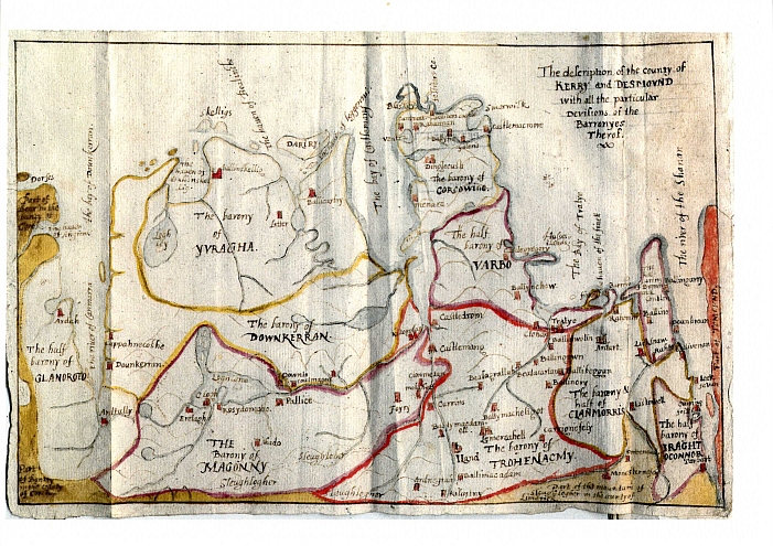
The "half barony of Varbo" shown between Trughanacmy and Corkaguiny on the map of the Desmond or Clancarthy Survey of 1598 may correspond to the medieval cantred of Uí Fearba / Hy Ferba / "Offariba otherwise Arbowe", which comprised the castle and lands of Listrim and Ballinoe. [4] [100] [101]
A barony of Drogheda in County Meath is listed in the 1841 and 1851 censuses. [102] [103] The territory included is the portion of the County of the Town of Drogheda outside the municipal borough of Drogheda and south of the River Boyne; this was detached from the County of the Town under the 1840 Act. However, the Local Government (Drogheda and Meath) Act 1845 first recites that this area was in fact transferred to County Louth under the 1840 Act (as part of the Louth barony of Drogheda) and then goes on to transfer the land to County Meath as part of Lower Duleek barony. [104]
{{cite book}}: CS1 maint: others (link){{cite book}}: CS1 maint: others (link)For repairing the road leading from Dundalk, in the county of Louth, through the upper half barony of the Fews to Armagh, and from thence to Dungannon, in the county of Tyrone.
To vest the inheritance of certain lands in the barony of Ibaune and Barryroe in the county of Cork in Francis Bernard, esquire
In 1412, Henry IV issued a charter uniting them into one borough, which was granted county status and full independence from both counties. Drogheda was followed by Dublin (1548), Carrickfergus (1569), Waterford (1574), Cork (1608), Limerick and Kilkenny (both 1609) and Galway (1610).
It was divided into baronies in 1585, which were in fact the traditional territories of the various branches of the Mac Mahons
At what time the Barony of Decies was divided into two distinct Baronies is uncertain; at present it is distinguish'd at the Assizes and Sessions into two parts, viz. Decies within and Decies without Drum.
On the other hand the baronies of the North Liberties of Limerick and of Kilculliheen to the north of Waterford city were not used in the 1851 or 1861 censuses but are shown separately in 1881.
Irish names have all been referenced from the 2008 Placenames Database of Ireland, published by the Department of Culture, Heritage and the Gaeltacht of the Government of Ireland: