
County Antrim is one of the six counties of Northern Ireland, located within the historic province of Ulster. Adjoined to the north-east shore of Lough Neagh, the county covers an area of 3,086 square kilometres (1,192 sq mi) and has a population of 651,321, as of the 2021 census. County Antrim has a population density of 211 people per square kilometre or 546 people per square mile. It is also one of the thirty-two traditional counties of Ireland.

East Antrim is a parliamentary constituency in the United Kingdom House of Commons. The current MP is Sammy Wilson of the DUP.

South Antrim is a parliamentary constituency in the United Kingdom House of Commons. The current MP is Paul Girvan of the Democratic Unionist Party.
The North East Liberties of Coleraine is a barony in County Londonderry, Northern Ireland. It borders the north-Londonderry coastline, and is bordered by three other baronies: Coleraine to the west; Dunluce Lower to the north-east; Dunluce Upper to the south-east. The North East Liberties of Coleraine formed the north-western part of the medieval territory known as the Route.

Glenarm Upper is a barony in County Antrim, Northern Ireland. To its east runs the east-Antrim coast, and it is bordered by four other baronies: Glenarm Lower to the north; Antrim Lower to the west; Antrim Upper to the south-west; and Belfast Lower to the south. Chaine Tower, situated at the entrance to Larne Lough, is located within Glenarm Upper.

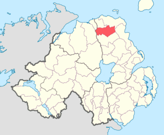
Glenarm Lower is a barony in County Antrim, Northern Ireland. To its east runs the east-Antrim coast, and it is bordered by five other baronies: Cary to the north; Dunluce Lower and Kilconway to the west; Antrim Lower to the south-west; and Glenarm Upper to the south-east.

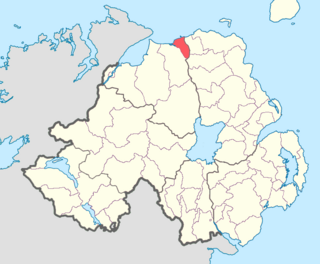
Cary is a historic barony in County Antrim, Northern Ireland. To its north is the north-Antrim coast, and it is bordered by three other baronies: Dunluce Lower to the west; Dunluce Upper to the south; and Glenarm Lower to the south-east. The Giant's Causeway is situated on the north coast of Cary. Dunineny Castle lies in the civil parish of Ramoan within this barony.

Dunluce Lower is a barony in County Antrim, Northern Ireland. To its north runs the north-Antrim coast, and it is bordered by three other baronies: Dunluce Upper to the south, Cary to the east, and the North East Liberties of Coleraine to the west. The River Bush flows through this barony. Dunluce Lower also formed the northern part of the medieval territory known as the Route.
Dunluce Upper is a barony in County Antrim, Northern Ireland. It is bordered by six other baronies: Dunluce Lower to the north; Cary to the north-east; North East Liberties of Coleraine to the north-west; Coleraine to the west; Kilconway to the south; and Glenarm Lower to the east. Dunluce Upper also formed part of the medieval territory known as the Route.

Kilconway is a barony in County Antrim, Northern Ireland. It is bordered by six other baronies: Dunluce Upper to the north; Glenarm Lower to the east; Antrim Lower to the south-east; Toome Lower to the south; Loughinsholin to the south-west; and Coleraine to the north-east. Kilconway also formed part of the medieval territory known as the Route. Springmount Bog is located within the barony.

Carrickfergus is a barony in County Antrim, Northern Ireland. It is bounded on the south-east by Belfast Lough, and otherwise surrounded by the barony of Belfast Lower. It is coextensive with the civil parish of Carrickfergus or St Nicholas and corresponds to the former county of the town of Carrickfergus, a county corporate encompassing Carrickfergus town.

Antrim Upper is a barony in County Antrim, Northern Ireland. It is bordered by six other baronies: Antrim Lower to the north; Toome Upper to the west; Massereene Lower to the south-west; Belfast Upper to the south; Belfast Lower to the south-east; and Glenarm Upper to the east.

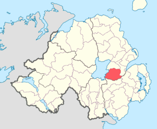
Belfast Upper is a barony in County Antrim, Northern Ireland. To its east lies the barony of Belfast and Belfast Lough, and it is bordered by five other baronies: Belfast Lower to the north-east; Antrim Upper to the north-west; Massereene Lower to the west; Massereene Upper to the south-west; and Castlereagh Upper to the south. The Forth River flows through both Belfast Upper and Lower. The most prominent hills in the barony are Black Hill and Lyle's Hill.

Massereene Lower is a barony in County Antrim, Northern Ireland. To its west lies Lough Neagh, and it is bordered by four other baronies: Massereene Upper to the south; Belfast Upper to the east; Antrim Upper to the north; and Toome Upper to the north-west.
Massereene Upper is a barony in southwest County Antrim, Northern Ireland. It roughly matches the former district of Killultagh. It includes settlements such as Crumlin, Glenavy, Lower Ballinderry, Maghaberry and Aghalee. To its east lies Belfast Lough, and it is bordered by four other baronies: Massereene Lower to the north; Belfast Upper to the east; Castlereagh Upper to the south-east; and Iveagh Lower, Lower Half to the south-west.

Toome Upper is a barony in County Antrim, Northern Ireland. To its south lies Lough Neagh, and it is bordered by five other baronies: Toome Lower to the north; Antrim Lower to the north-east; Antrim Upper to the east; Massereene Lower to the south-east; and Loughinsholin to the south-east. Toome Upper also formed part of the medieval territories known as the Route and Clandeboye.

Toome Lower is a barony in County Antrim, Northern Ireland. It is bordered by four other baronies: Toome Upper to the south; Antrim Lower to the east; Kilconway to the north; and Loughinsholin to the west. Toome Lower also formed part of the medieval territories known as the Route and Clandeboye.

Armagh is a barony in County Armagh, Northern Ireland. It lies in the west of the county, bordering County Tyrone with its north-western boundary, and bordering the Republic of Ireland with its southern boundary. It is bordered by five other baronies in Northern Ireland: Tiranny to the west, Dungannon Middle to the north-west, Oneilland West to the north-east, Fews Lower to the east, and Fews Upper to the south-east. It also borders to the south the barony of Cremorne in the Republic of Ireland.

Castlereagh Upper is a historic barony in County Down, Northern Ireland. It was created by 1841 with the division of Castlereagh into two. It is bordered by eight other baronies: Castlereagh Lower and Dufferin to the east; Lecale Lower and Kinelarty to the south; Iveagh Lower, Lower Half, Iveagh Lower, Upper Half, and Massereene Upper to the west; and Belfast Upper to the north.

