
The Arctic Archipelago, also known as the Canadian Arctic Archipelago, is an archipelago lying to the north of the Canadian continental mainland, excluding Greenland and Iceland.

Larne is a town on the east coast of County Antrim, Northern Ireland, with a population of 18,755 at the 2011 Census. It is a major passenger and freight roll-on roll-off port. Larne is administered by Mid and East Antrim Borough Council. Together with parts of the neighbouring districts of Antrim and Newtownabbey and Causeway Coast and Glens, it forms the East Antrim constituency for elections to the Westminster Parliament and Northern Ireland Assembly. The civil parish is in the historic barony of Glenarm Upper.
Wigtownshire or the County of Wigtown is one of the historic counties of Scotland, covering an area in the south-west of the country. Until 1975, Wigtownshire was an administrative county used for local government. Since 1975 the area has formed part of Dumfries and Galloway for local government purposes. Wigtownshire continues to be used as a territory for land registration, being a registration county. The historic county is all within the slightly larger Wigtown Area, which is one of the lieutenancy areas of Scotland and was used in local government as the Wigtown District from 1975 to 1996.
Carrick Rangers Football Club is a semi-professional Northern Irish football club playing in NIFL Premiership. The club, founded in 1939, hails from Carrickfergus, County Antrim and plays its home matches at Taylors Avenue which is known as the Loughview Leisure Arena due to sponsorship reasons, which is owned by Mid and East Antrim Borough Council. Carrick Rangers main rivals are Larne, with matches between the sides being known as, "The East Antrim Derby." Ballyclare Comrades are also local rivals.
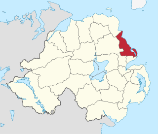
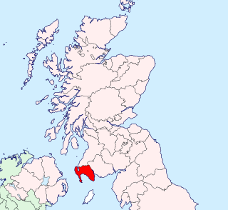
Larne Borough Council was a Local Council in County Antrim in Northern Ireland. It merged with Ballymena Borough Council and Carrickfergus Borough Council in May 2015 under the reorganisation of local government in Northern Ireland to become Mid and East Antrim Borough Council.

Belfast Lough is a large, intertidal sea inlet on the east coast of Northern Ireland. At its head is the city and port of Belfast, which sits at the mouth of the River Lagan. The lough opens into the North Channel and connects Belfast to the Irish Sea.

Seaforde is a small village in County Down, Northern Ireland. It is within the townland of Naghan, one mile (1.6 km) north of Clough on the main Ballynahinch to Newcastle road. It is part of the Newry, Mourne and Down area.

Glenoe or Gleno is a hamlet in County Antrim, Northern Ireland. It is halfway between Larne and Carrickfergus. In the 2001 Census, it had a population of 87 people. Glenoe is in the Mid and East Antrim Borough Council area.
Mill Bay is a small village on Islandmagee in County Antrim, Northern Ireland. It sits by the tiny Carnspindle Bay, within the townland of Carnspindle. It is in the Larne Borough Council area. In the 2011 Census it had a population of 103 people. .
Gawley's Gate is a small village in County Antrim, Northern Ireland. It is situated on the south-eastern shore of Lough Neagh, seven miles to the north of Lurgan and ten miles west of Lisburn. It has a jetty and picnic areas, popular amongst many boating enthusiasts on the Lough. It consists of a small number of houses in close proximity; however, it is a focal point for much of the countryside on the shore of Lough Neagh from Glenavy to Aghagallon. The rural location means that much of the community is involved in farming in some capacity as well as fishing. The landscape is quite wet with marshland in places and dense woods giving way to cleared hillocks or 'islands' where settlements have developed. It also a popular destination with wildfowlers and birdwatchers due to the habitat which exists particularly around the RSPB sanctuary at nearby Portmore Lough.

Clongriffin is a community in northern Donaghmede, on the northern fringe of Dublin, Ireland. The settlement was based on a master plan vision from major developer Gannon Homes, with significant investment in transport infrastructure and also community and recreational amenities. Development slowed during the downturn in the economy, although activity renewed in recent years, with planning permission secured for a hotel and range of additional homes including a 16-storey apartment block with residential lounges and roof gardens..

The Ballymena and Larne Railway was a 3 ft narrow gauge railway in County Antrim, Northern Ireland. The first part opened in July 1877 and regular passenger services began in August 1878, the first on the Irish 3 ft gauge railways. Passenger services ended in 1933 and the last part of the railway closed in 1950.

'Galgorm' is a townland in County Antrim, Northern Ireland, about 1 km west of Ballymena. It is part of the civil parish of Ahoghill. Administratively, it is in the Borough of Ballymena.

Mullaghmore is a mountain in County Londonderry, Northern Ireland. It is part of the Sperrins and the 359th highest point on the island of Ireland The summit is dominated by a large telecommunication tower. The peak is located 5 miles north of the village of Draperstown, and 6 miles south of Dungiven. It is also locally known as, "The Birren" hence the road name passing over it is "Birren Road"

Carnfunnock Country Park is a 191-hectare park located between Drains Bay and Ballygally, near Larne, County Antrim, Northern Ireland. It is situated on the A2 Antrim Coast Road, 3.5 miles north of Larne. The park consists of mixed woodland, gardens, walking trails and coastline with views of the Antrim Coast and North Channel. and is owned and run by Mid and East Antrim Borough Council.
Tasiusaq Bay is a bay in the Upernavik Archipelago in the Avannaata municipality in northwestern Greenland. It is an indentation of northeastern Baffin Bay. The name of the bay derives from the name of the settlement of the same name in the bay.
Bobby McKee, MBE was a Unionist politician in Larne, Northern Ireland and former member of the Ulster Volunteer Force.

Browns Bay is a small sandy bay on the northern tip of the Islandmagee peninsula, near Larne in County Antrim, Northern Ireland. The car park has 150 spaces. The caravan park closed in 2014 for operational reasons. A review of the facilities is currently being carried out. Dogs must be on a lead between 11.00 am and 6.00 pm from 1 June -31 August plus all Public and Bank Holidays. A Fixed Penalty of £80 is applicable. Outside these hours and for the rest of year there are no restrictions. However, owners are nevertheless asked to use their own good judgement, for example do not allow dogs loose if there are many people on the beach. Dog foul must never be left anywhere including the less accessible grass or stony areas. Place into the bins provided. A small shop is open part-time hours. Toilets have disabled and baby changing facilities. They are cleaned every day and open all year.

Kingswood, occasionally referred to as Kingswood Parks, is a modern housing estate on the northern fringe of Kingston upon Hull, England.

