The townland of Randalstown was originally known as An Dún Mór ("the great fort"), anglicised as Dunmore. This refers to a medieval motte-and-bailey castle built by the Irish on the west bank of the river Main just south of the town.[5] A castle known as Edenduffcarrick, later Shane's Castle, was built near Randalstown in the 14th century by the O'Neills of Clannaboy.
From at least the 1650s the town was known as "Iron Mills" (Muilinn Iarainn in Irish, anglicised "Mullynieren").[5] In 1667, the town was created a free borough and was officially renamed Randalstown.[5] It was renamed to mark the marriage of Randal MacDonnell, 1st Marquess of Antrim to Rose O'Neill of Shane's Castle.[5]
The 1798 United Irishmen rebellion began in Antrim following a meeting to prepare for revolt by the Ulster Directory on 1 February 1798, at McClean's Inn, Randalstown. Robert McClean's "Great Inn" had long been an Irish Volunteers meeting place. Following his death in 1790, his son Francis became the proprietor.[6]
Randalstown has a strong history of linen and iron industries. A memorial to this history is in the middle of the town and made from the original turbine used to generate mains electricity for the town and items salvaged from the Old Bleach Linen Company founded by James Webb in 1864. An old linen mill chimney from the Old Bleach factory can be seen from most parts of the town. The Dorma Old Bleach factory which operated from a neighbouring site closed down in 2002.
On 8 January 2010, PSNI Constable Peadar Heffron was seriously injured as a bomb exploded under his car on the Milltown Road near Randalstown. Dissident republicans were blamed for the attack.[7][8]
Demography
2021 census
National Identity of Randalstown residents (2021)
Nationality
Per cent
British
36.9%
Northern Irish
33.8%
Irish
31.0%
On census day (21 March 2021) the usually resident population of Randalstown was 5,151.[4] Of these:
55.39% belong to or were brought up Catholic and 35.14% belong to or were brought up in a 'Protestant and other (non-Catholic) Christian (including Christian related)'.[9]
36.94% indicated that they had a British national identity,[10] 30.98% had an Irish national identity[11] and 33.76% had a Northern Irish national identity.[12]
2011 census
National Identity of Randalstown residents (2011)
Nationality
Per cent
British
46.3%
Northern Irish
32.9%
Irish
24.3%
On census day (27 March 2011) the usually resident population of Randalstown was 5,126 accounting for 0.28% of the NI total.[13][14] Of these:
99.02% were from the white (including Irish Traveller) ethnic group
54.74% belong to or were brought up Catholic and 39.82% belong to or were brought up in a 'Protestant and other (non-Catholic) Christian (including Christian related)'
46.29% indicated that they had a British national identity, 24.33% had an Irish national identity and 32.91% had a Northern Irish national identity.
10.67% had some knowledge of Irish; 9.30% had some knowledge of Ulster-Scots; and 4.72% did not have English as their first language.
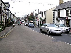
Lower Main Street in RandalstownOC Presbyterian Church
The Tudor style gateway to the Shane's Castle estate is in the town.
Randalstown OC Presbyterian Church is an example of Irish Gothic church architecture.[citation needed]
Around the corner from the gateway is the seven-piered, viaduct built in 1855 to carry the railway line over the River Main. This has had a new bridge installed and a walk path created as part of the local healthy walking areas.[16]
Craigmore Fishery, a fly fishing facility, is located on the outskirts of town.
"World of Owls", Northern Ireland's only owl, bird of prey and exotic animal conservation centre is located next to Randalstown Forest.[citation needed]
Caddy, a hamlet 3 miles north of the Randalstown centre, was site of a new school in 1908.[17] and also a centre of beekeeping in the 1950s.[18]
John Bodkin Adams, a British doctor and suspected serial killer, was born to a Plymouth Brethren family in Randalstown on 21 January 1899 and lived here until 1901. He was charged in 1957 with the murder of two patients but was acquitted. He was, however, suspected of causing the death of 163 other patients.[19]
↑Ireland, Culture Northern (8 February 2006). "Ulster's Hiddlin Swaatch". culturenorthernireland.org. Archived from the original on 22 June 2018. Retrieved 1 August 2011.
↑THE PARALIAMENTARY DEBATES – Page cccxlix 1908 Erection of New School at Caddy, Randalstown. Mr. SLOAN (Belfast, S.): To ask the Chief Secretary to the Lord-Lieutenant of Ireland, if plans and specifications have been prepared for the erection of a new school at Caddy, Randalstown ...
↑British Bee Journal – Volume 102 – Page 259 1974 ... spirit level in setting the hive, and I have a vivid memory of a beautiful comb of eggs from a valuable breeder queen in Belfast being wrapped up for transport to Caddy, Randalstown, where nineteen virgin queens developed from it in 1953.
↑Cullen, Pamela V., "A Stranger in Blood: The Case Files on Dr John Bodkin Adams", London, Elliott & Thompson, 2006, ISBN1-904027-19-9
This page is based on this Wikipedia article Text is available under the CC BY-SA 4.0 license; additional terms may apply. Images, videos and audio are available under their respective licenses.