
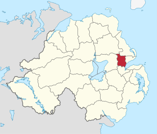
County Antrim is one of the six counties of Northern Ireland, located within the historic province of Ulster. Adjoined to the north-east shore of Lough Neagh, the county covers an area of 3,086 square kilometres (1,192 sq mi) and has a population of 651,321, as of the 2021 census. County Antrim has a population density of 211 people per square kilometre or 546 people per square mile. It is also one of the thirty-two traditional counties of Ireland.

Carrickfergus is a large town in County Antrim, Northern Ireland. It sits on the north shore of Belfast Lough, 11 miles (18 km) from Belfast. The town had a population of 28,141 at the 2021 census. It is County Antrim's oldest town and one of the oldest towns in Ireland as a whole. Carrickfergus Castle, built in the late 12th century at the behest of Anglo-Norman knight John de Courcy, was the capital of the Earldom of Ulster. After the earldom's collapse, it remained the only English outpost in Ulster for the next four centuries. Carrickfergus was the administrative centre for Carrickfergus Borough Council, before this was amalgamated into the Mid and East Antrim District Council in 2015, and forms part of the Belfast Metropolitan Area. It is also a townland of 65 acres, a civil parish and a barony.

Glengormley is a townland and electoral ward in County Antrim, Northern Ireland. Glengormley is within the urban area of Newtownabbey bordering Belfast, and is located in the Antrim and Newtownabbey Borough Council area. It is also situated in the civil parish of Carnmoney and the historic barony of Belfast Lower.

Ballyclare is a small town in County Antrim, Northern Ireland. It had a population of 10,850 according to the 2021 census, and is located within the Antrim and Newtownabbey Borough Council area. It is part of, and the principal settlement in the Ballyclare District Electoral Area.
Newtownabbey Borough Council was a Local Authority in County Antrim in Northern Ireland, on the north shore of Belfast Lough just immediately north of Belfast. The Council merged with Antrim Borough Council in April 2015 under local government reform in Northern Ireland to form Antrim and Newtownabbey Borough Council.

South Antrim is a parliamentary constituency in the United Kingdom House of Commons. The current MP is Robin Swann (UUP)

Antrim is a town and civil parish in County Antrim, Northern Ireland. It lies on the banks of the Six Mile Water on the north-east shore of Lough Neagh. It had a population of 25,606 people in the 2021 census. It is the county town of County Antrim and was the administrative centre of Antrim Borough Council until its 2015 merger with Newtownabbey Borough Council to form Antrim and Newtownabbey Borough Council. The town lies 14 miles (23 km) north-west of Belfast.
Ballyclare High School is a co-educational, non-denominational grammar school in Ballyclare, County Antrim, Northern Ireland. There are approximately 1,200 pupils at the school, taught by around 80 teachers.

Belfast Castle is a mansion located in Cave Hill Country Park in Belfast, Northern Ireland, in a prominent position 400 feet (120 m) above sea level. Its location provides unobstructed views over the City of Belfast and Belfast Lough. There have been several structures called "Belfast Castle" over the centuries, located on different sites. The current "castle" is a Victorian structure, built between 1867 and 1870 on the slopes of Cave Hill, and is Grade A listed. The main entrance into the Belfast Castle Demesne is now where Innisfayle Park meets Downview Park West, just off the Antrim Road. The original main entrance into the current demesne was formerly on the Antrim Road itself, where Strathmore Park now meets the Antrim Road.
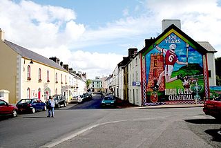
Cushendall, formerly known as Newtownglens, is a coastal village and townland in County Antrim, Northern Ireland. It is located in the historic barony of Glenarm Lower and the civil parish of Layd, and is part of Causeway Coast and Glens district.
Toome or Toomebridge is a small village and townland on the northwest corner of Lough Neagh in County Antrim, Northern Ireland. It lies in the civil parish of Duneane in the former barony of Toome Upper, and is in the Antrim and Newtownabbey Borough Council area. It had a population of 781 in the 2011 census.
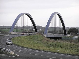
The A36 is a road in Northern Ireland. It travels through County Antrim, connecting the large towns of Ballymena and Larne. The road is a single-carriageway primary route. It has three named sections: Church Road, Moorfields Road, and Shane's Hill or Shaneshill (Road).

Straid is a small village in County Antrim, Northern Ireland, about three miles east of Ballyclare, and about six miles inland from Carrickfergus. It lies at the centre of the townland of Straidlands, in the Civil Parish of Ballynure within the Antrim and Newtownabbey Borough Council area, and in the former barony of Belfast Lower. The village has a congregational church, an Orange hall, and a primary school.

William Paul Girvan is a retired Democratic Unionist Party (DUP) politician who was the Member of Parliament (MP) for South Antrim from 2017 to 2024. In this role, Girvan was the DUP's spokesperson for Transport. He was previously a Member of the Northern Ireland Assembly (MLA) for South Antrim from 2003 to 2007, and then from 2010 to 2017.
William Alexander Fraser Agnew, known as Fraser Agnew, is a retired Northern Irish unionist politician who was an Antrim and Newtownabbey Councillor for the Three Mile Water DEA from 2014 to 2023. He was previously an Independent Unionist Member of the Legislative Assembly (MLA) for Belfast North from 1998 to 2003.
Parkview Hockey Club is a hockey club affiliated to the Ulster Branch of the Irish Hockey Association. It was founded as Fisherwick Hockey Club in 1898, changing its name to Parkview in 1924. It is based in the County Antrim village of Doagh, near Ballyclare. The club's founding members were workers from the local spinning mills and from agriculture. The club currently plays in Junior 5 of the Ulster Junior Leagues. It fields two teams every Saturday.

The Ballymena and Larne Railway was a 3 ft narrow gauge railway in County Antrim, Northern Ireland. The first part opened in July 1877 and regular passenger services began in August 1878, the first on the Irish 3 ft gauge railways. Passenger services ended in 1933 and the last part of the railway closed in 1950.
Ballyclare Town Hall is a municipal structure in The Square, Ballyclare, County Antrim, Northern Ireland. The structure, which is primarily used as an events venue, is a Grade B2 listed building.
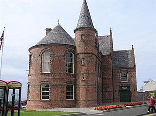
Portrush Town Hall is a municipal structure in Mark Street, Portrush, County Antrim, Northern Ireland. The structure, which is used as an events venue, is a Grade B+ listed building.


