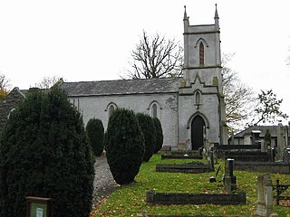
Templepatrick is a village and civil parish in County Antrim, Northern Ireland. It is 9.2 miles (14.8 km) northwest of Belfast, and halfway between the towns of Ballyclare and Antrim. It is also close to Belfast International Airport and the village has several hotels. Templepatrick is the site of historic Church of Ireland, Presbyterian and the Old Presbyterian Church. It had a population of 1,437 people in the 2011 Census.

Rasharkin is a small village, townland and civil parish in County Antrim, Northern Ireland. It is 13 kilometres (8.1 mi) south of Ballymoney, near Dunloy and Kilrea. It had a population of 1,114 people in the 2011 Census.

Claudy is a village and townland in County Londonderry, Northern Ireland. It lies in the Faughan Valley, 6 miles (9.7 km) southeast of Derry, where the River Glenrandal joins the River Faughan. It is situated in the civil parish of Cumber Upper and the historic barony of Tirkeeran. It is also part of Derry and Strabane district.

Aghagallon (from Irish Achadh Gallan , meaning 'field of the standing stones' is a small village and civil parish in County Antrim, Northern Ireland. It is about three miles northeast of Lurgan, County Armagh, and had a population of 824 in the 2001 census.

Annahilt / Anahilt is a village and civil parish in north County Down, Northern Ireland. It is 7.5 miles south of Lisburn, and about 14 miles south-west of Belfast, on the main road between Ballynahinch and Hillsborough. In the 2001 Census the village had a population of 1,148. Annahilt has a distinctive drumlin setting, with a small wooded estate on a ridge to the west, and panoramic views on the approaches to the village.

Articlave is a village and townland in County Londonderry, Northern Ireland. It is on the main A2 coastal road, 7 kilometres west of Coleraine. Castlerock railway station is 1 mile (1.6 km) to the north. In the past the area has been spelt as Ardacleve or Ardacleave. It is situated within the Causeway Coast and Glens district.

Ballywalter is a village or townland and civil parish in County Down, Northern Ireland. It is on the east coast of the Ards Peninsula between Donaghadee and Ballyhalbert. Ballywalter was formerly known as Whitkirk as far back as the 12th century. It had a population of 2,027 people in the 2011 census.
Balnamore is a small village in County Antrim, Northern Ireland. It is within the townland of Ballynacree-Skein and lies 3 km west of Ballymoney. It is part Causeway Coast and Glens District Council. Historically it was known as Ballinamore.

Cloghy, also spelt Cloughey or Cloughy, is a small village and townland in County Down, Northern Ireland. It lies on the east coast of the Ards Peninsula, in the Ards and North Down Borough. It had a population of 1,075 people in the 2011 Census.

Dervock is a small village and townland in County Antrim, Northern Ireland. It is about 3.5 miles (6 km) northeast of Ballymoney, on the banks of the River Bush. It is situated in the civil parish of Derrykeighan and the historic barony of Dunluce Lower. It had a population of 714 people in the 2011 Census.
Dromara is a village, townland and civil parish in County Down, Northern Ireland. It lies 10 kilometres (6.2 mi) to the southwest of Ballynahinch on the northern slopes of Slieve Croob, with the River Lagan flowing through it. It is situated in Dromara and the historic barony of Iveagh Lower, Lower Half. In the 2011 census it had a population of 1,006 people.

Drumaness is a village and townland in the Newry, Mourne and Down District Council area of County Down, Northern Ireland. It is 3 miles or 5 kilometres south of Ballynahinch, beside the main A24 Belfast to Newcastle road. It is situated in the civil parish of Magheradroll and the historic barony of Kinelarty. In the 2011 census it had a population of 1,339 people.

Drumbeg is a small village, townland and civil parish on the south bank of the River Lagan in County Down, Northern Ireland. The village is covered by the Lisburn City Council area and forms part of the suburban fringe of Belfast.

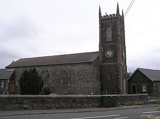
Kilrea is a village, townland and civil parish in County Londonderry, Northern Ireland. It gets its name from the ancient church that was located near to where the current Church of Ireland is located on Church Street looking over the town. It is near the River Bann, which marks the boundary between County Londonderry and County Antrim. In the 2011 Census it had a population of 1,678 people. It is situated within Causeway Coast and Glens district.

Laurelvale is a village in County Armagh, Northern Ireland. It is beside the smaller village of Mullavilly and the two are sometimes referred to as Laurelvale-Mullavilly or Mullavilly-Laurelvale. The village is three miles south of Portadown and 1.5 miles northwest of Tandragee. It had a population of 1,288 people in the 2011 census.
Macosquin is a small village, townland, and civil parish in County Londonderry, Northern Ireland. It is 4 kilometres (2.5 mi) south-west of Coleraine, on the road to Limavady. In the 2011 Census it had a population of 614 people. The area is known for its caves and springs. It is situated within Causeway Coast and Glens district.
Maghaberry or Magaberry is a village and townland in County Antrim, Northern Ireland. It is 9 kilometres (5.6 mi) west of Lisburn and 4 kilometres (2.5 mi) north of Moira. In the 2011 Census it had a population of 4,716 people. It is one of the biggest villages within the Lisburn and Castlereagh City Council area.

Cargan is a hamlet and townland in County Antrim, Northern Ireland. It lies at the foot of Slievenanee in Glenravel – locally known as "The Tenth Glen" along with the more widely known nine Glens of Antrim. It is part of Mid and East Antrim district. It had a population of 588 people in the 2011 Census.

Upper Ballinderry is a small village to the east of Lower Ballinderry in County Antrim, Northern Ireland. It is within the townland of Ballyscolly and civil parish of Ballinderry, the historic barony of Massereene Upper. Upper Ballinderry is about 10 miles (15 km) north- west of Lisburn. In the 2001 Census it had a population of 192 people.
Ballyvoy is a small village and townland in County Antrim, Northern Ireland. It is on the main A2 coast road 5 km east of Ballycastle and 17 km north west of Cushendall. In the 2001 Census it had a population of 72 people. It lies within the Antrim Coast and Glens Area of Outstanding Natural Beauty and is part of Causeway Coast and Glens District Council.


