Related Research Articles
Donegore is the name of a hill, a townland, a small cluster of residences, and a civil parish in the historic barony of Antrim Upper, County Antrim, Northern Ireland. Donegore lies approximately 5 miles (8 km) east of Antrim town. 154 acres of the townland lies in the civil parish of Grange of Nilteen.

Dunadry is a hamlet and townland 3 miles (5 km) from Antrim in County Antrim, Northern Ireland. It is situated in the civil parish of Grange of Nilteen and the historic barony of Antrim Upper. It is within the Antrim and Newtownabbey Borough Council area. It had a population of 430 people in the 2011 Census..
Monkstown is a townland and electoral ward in County Antrim, Northern Ireland. It is within the urban area of Newtownabbey and the Antrim and Newtownabbey Borough Council area. The townland was previously called Ballynamanagh It is also situated in the civil parish of Carnmoney and the historic barony of Belfast Lower.
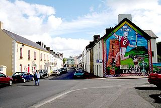
Cushendall, formerly known as Newtownglens, is a coastal village and townland in County Antrim, Northern Ireland. It is in the historic barony of Glenarm Lower and the civil parish of Layd, and is part of Causeway Coast and Glens district.
Knocknacarry is a hamlet and townland about 1 kilometre west of Cushendun in County Antrim, Northern Ireland. It is situated in the historic barony of Glenarm Lower and the civil parish of Layd. In the 2001 Census it had a population of 138 people. It is within the Moyle District Council area.

Waterfoot or Glenariff is a small coastal village in County Antrim, Northern Ireland. It is at the foot of Glenariff, one of the Glens of Antrim, within the historic barony of Glenarm Lower and the civil parishes of Ardclinis and Layd. The village is in the townland of Warren. The 2001 Census recorded a population of 504 inhabitants.
Ballyscullion is a small village and civil parish in County Londonderry, Northern Ireland. In the 2001 Census it had a population of 291 people. The civil parish of Ballyscullion covers areas of County Antrim as well as County Londonderry. The village is situated within Mid-Ulster District.

Desertmartin is a civil and ecclesiastical parish in County Londonderry, Northern Ireland. Containing one major settlement, Desertmartin, it is bordered by the civil parishes of Ballynascreen, Desertlyn, Kilcronaghan, Lissan, Maghera, and Magherafelt. It lies within the former barony of Loughinsholin and is situated in Magherafelt District Council. As a Church of Ireland parish it is within the Diocese of Derry and Raphoe.

Glenarm Lower is a barony in County Antrim, Northern Ireland. To its east runs the east-Antrim coast, and it is bordered by five other baronies: Cary to the north; Dunluce Lower and Kilconway to the west; Antrim Lower to the south-west; and Glenarm Upper to the south-east.

Carrickfergus is a barony in County Antrim, Northern Ireland. It is bounded on the south-east by Belfast Lough, and otherwise surrounded by the barony of Belfast Lower. It is coextensive with the civil parish of Carrickfergus or St Nicholas and corresponds to the former county of the town of Carrickfergus, a county corporate encompassing Carrickfergus town.
Upper Broghindrummin is a townland of 186 acres in County Antrim, Northern Ireland. It is situated in the historic barony of Glenarm Lower and the civil parish of Layd.
Layd is a civil parish and townland in County Antrim, Northern Ireland. It is situated in the historic barony of Glenarm Lower.
Grange of Nilteen is a civil parish in County Antrim, Northern Ireland. It is situated in the historic barony of Antrim Upper. It is 3.5 miles east of Antrim on the Six Mile Water River.
Islandreagh is a townland of 392 acres in County Antrim, Northern Ireland. It is situated in the civil parish of Grange of Nilteen and the historic barony of Antrim Upper.
Rathbeg is a townland in County Antrim, Northern Ireland. It is situated in the civil parishes of Grange of Nilteen and Donegore, both in the historic barony of Antrim Upper.
References
- ↑ "Parishes of Ulster". Ulster Ancestry. Retrieved 2 January 2009.
