
Downpatrick is a town in County Down, Northern Ireland. It is on the Lecale peninsula, about 21 mi (34 km) south of Belfast. In the Middle Ages, it was the capital of the Dál Fiatach, the main ruling dynasty of Ulaid. Its cathedral is said to be the burial place of Saint Patrick. Today, it is the county town of Down and the joint headquarters of Newry, Mourne and Down District Council. Downpatrick had a population of 11,545 according to the 2021 Census.

Ahoghill is a large village and civil parish in County Antrim, Northern Ireland, four miles from Ballymena. It is located in the Mid and East Antrim Borough Council area. It had a population of 3,417 people at the 2011 Census.

Down Cathedral, the Cathedral Church of the Holy and Undivided Trinity, is a Church of Ireland cathedral located in the town of Downpatrick in Northern Ireland. It stands on Cathedral Hill overlooking the town. It is one of two cathedrals in the Diocese of Down and Dromore. The cathedral is the centre point of Downpatrick, a relatively new name for the settlement, having only come into usage in the seventeenth century.

Ballymena is a town in County Antrim, Northern Ireland. It had a population of 31,205 people at the 2021 Census, making it the seventh largest town in Northern Ireland by population. It is part of the Borough of Mid and East Antrim.

Bangor Abbey was established by Saint Comgall in 558 in Bangor, County Down, Northern Ireland and was famous for its learning and austere rule. It is not to be confused with the slightly older abbey in Wales on the site of Bangor Cathedral.
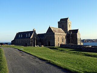
Iona Abbey is an abbey located on the island of Iona, just off the Isle of Mull on the West Coast of Scotland.

Clogh, also spelt as Clough, is a small village in County Antrim, Northern Ireland, 9 miles from Ballymena. It is situated within the Glenravel ward of the Braid electoral area of Mid and East Antrim District Council. It had a population of 220 people in the 2011 Census.
Martinstown is a small village in County Antrim, Northern Ireland. Located 6 miles from Ballymena, it is situated in Glenravel, locally known as "The Tenth Glen", alongside the widely known nine Glens of Antrim.

Armoy is a village and civil parish in County Antrim, Northern Ireland. It is 5.5 miles (9 km) southwest of Ballycastle and 8 miles (13 km) northeast of Ballymoney. According to an estimate in 2013 by the Northern Ireland Statistics and Research Agency it had a population of 1,122.

Straid is a small village in County Antrim, Northern Ireland, about three miles east of Ballyclare, and about six miles inland from Carrickfergus. It lies at the centre of the townland of Straidlands, in the Civil Parish of Ballynure within the Antrim and Newtownabbey Borough Council area, and in the former barony of Belfast Lower. The village has a congregational church, an Orange hall, and a primary school.

The Diocese of Connor is in the Province of Armagh of the Church of Ireland.
The Bishop of Meath is an episcopal title which takes its name after the ancient Kingdom of Meath. In the Roman Catholic Church it remains as a separate title, but in the Church of Ireland it has been united with another bishopric.

The Ballymena and Larne Railway was a 3 ft narrow gauge railway in County Antrim, Northern Ireland. The first part opened in July 1877 and regular passenger services began in August 1878, the first on the Irish 3 ft gauge railways. Passenger services ended in 1933 and the last part of the railway closed in 1950.
William Reeves was an Irish antiquarian and the Church of Ireland Bishop of Down, Connor and Dromore from 1886 until his death. He was the last private keeper of the Book of Armagh and at the time of his death was President of the Royal Irish Academy.
The Battle of Connor was fought on 10 September 1315, in the townland of Tannybrake just over a mile north of what is now the modern village of Connor, County Antrim. It was part of the Bruce campaign in Ireland.
Clones Abbey is a ruined monastery that later became an Augustinian abbey in the twelfth century, and its main sights are ecclesiastical. The Abbey was formerly known as St. Tighernach Abbey, and was referred to locally as the "wee abbey". Parochial and monastic settlements were separated, and it seems likely that the building became the Abbey of St. Peter and Paul. In the Book of Armagh and Annals of Ulster the word Clones is referenced as "Clauin Auis" and "Cluain Auiss," respectively. As there is no word in standard dictionaries of Old Irish that give the form "auis" or "eois", Seosamh Ó Dufaigh has speculated that the word is a cognate of the Welsh word for point or a tip: "awch". Although, Bearnard O'Dubhthaigh disputes this theory on the grounds that the earlier form of "awch" is "afwch". Folklore suggests that the monastic town was originally called "Cluin Innish" on account of it being surrounded by water.

Drumlane is a townland situated near the village of Milltown, area 85.76 hectares, in County Cavan, Ireland. Drumlane is also the name of the civil parish in which the townland is situated. Saint Columba brought Christianity to Drumlane in 555, and Saint Máedóc of Ferns was the patron saint of Drumlane Abbey. Saint Máedóc made the Connachta nobleman Faircheallaigh the first Abbot of Drumlane in the 7th century and his Ó Faircheallaigh descendants were historically the Abbots of Drumlane. The name Drumlane denotes the drumlin region of low hilly ribbed moraines formed over a limestone bedrock created by the movement of glacial ice and melt water during the last ice age. Several townlands in the neighbourhood are prefixed with the word 'Drum' ('Droim'), while several others are prefixed with the word 'Derry' ('Doire'), which is Irish for oak.
The 1859 Ulster revival was a Christian revival in Ulster which spread to the rest of the United Kingdom. It has been reported that the revival produced 100,000 converts.

Saul Monastery is a former Christian monastery located in County Down, Northern Ireland. It is traditionally associated with the 5th-century Saint Patrick, who is said to have founded it shortly after arriving in Ireland, and having died there at the end of his missionary work.


