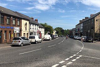
Cookstown is a town in County Tyrone, Northern Ireland. It is the fourth-largest town in the county and had a population of 12,546 in the 2021 census. It, along with Magherafelt and Dungannon, is one of the main towns in the Mid-Ulster council area. It was founded around 1620 when the townlands in the area were leased by an English ecclesiastical lawyer, Dr. Alan Cooke, from the Archbishop of Armagh, who had been granted the lands after the Flight of the Earls during the Plantation of Ulster. It was one of the main centres of the linen industry west of the River Bann, and until 1956 the flax-related processes of spinning, weaving, bleaching and beetling were carried out in the town.

Kilkeel is a small town, civil parish and townland in County Down, Northern Ireland. It is the southernmost town in Northern Ireland. It lies within the historic barony of Mourne. Kilkeel town is the main fishing port on the Down coast, and its harbour is home to the largest fishing fleet in Northern Ireland. It had a population of 6,633 people at the 2021 census. The town contains the ruins of a 14th-century church and fort, winding streets and terraced shops. It lies just south of the Mourne Mountains.

Dromore is a town, townland and civil parish in County Tyrone, Northern Ireland. It is nine miles (14 km) south west of Omagh on the A32 and sixteen miles (26 km) from Enniskillen. The population of Dromore was 1,198 at the 2011 Census.

Doagh is a village and townland in County Antrim, Northern Ireland. It is in the Six Mile Water Valley, about two miles south-west of Ballyclare, and had a population of 1,404 people in the 2021 census. It is known as Doach in Scots.

Fintona, is a village and townland in County Tyrone, Northern Ireland. Its population at the 2011 Census was 1,164.

Carrickmore is a small town in County Tyrone, Northern Ireland. It is situated in the historic barony of Omagh East, the civil parish of Termonmaguirk and the Roman Catholic Parish of Termonmaguirc between Cookstown, Dungannon and Omagh. It had a population of 612 in the 2001 Census. In the 2011 Census 2,330 people lived in the Termon Ward, which covers the Carrickmore and Creggan areas.

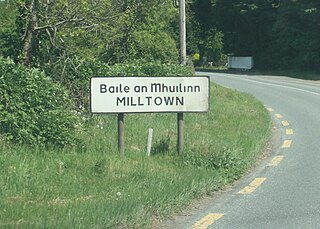
Milltown is a suburb and townland on the southside of Dublin, Ireland. Milltown was the site of several working mills on the River Dodder and is also the location of the meeting of the River Slang with the Dodder. It is located adjacent to other suburban areas such as Windy Arbour, Ranelagh, Rathmines, Dartry, Clonskeagh, and Donnybrook.

Aghalee is a village, townland and civil parish in County Antrim, Northern Ireland. It is three miles from the southeast corner of Lough Neagh on the main road between Lurgan and Antrim and about 13 kilometres west of Lisburn. The village lies on the steep wooded slopes of Friar's Glen and is beside the now disused Lagan Navigational Canal. In the 2001 census, Aghalee had a population of 774.

Annahilt / Anahilt is a village and civil parish in north County Down, Northern Ireland. It is 7.5 miles south of Lisburn, and about 14 miles south-west of Belfast, on the main road between Ballynahinch and Hillsborough. In the 2001 Census the village had a population of 1,148. Annahilt has a distinctive drumlin setting, with a small wooded estate on a ridge to the west, and panoramic views on the approaches to the village.
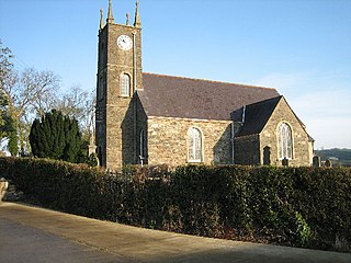
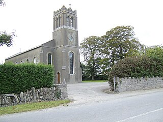
Donaghmore is a village, townland and civil parish in County Tyrone, Northern Ireland, about five kilometres (3 mi) north-west of Dungannon. In the 2011 Census it had a population of 1,122 people. The village is beside the River Torrent, formerly known as the Torrent Flow.
Dromara is a village, townland and civil parish in County Down, Northern Ireland. It lies 10 kilometres (6.2 mi) to the southwest of Ballynahinch on the northern slopes of Slieve Croob, with the River Lagan flowing through it. It is situated in Dromara and the historic barony of Iveagh Lower, Lower Half. In the 2011 census it had a population of 1,006 people.

Killinchy is a townland and small village in County Down, Northern Ireland. It is two miles inland from the western shores of Strangford Lough in the Borough of Ards and North Down. It is situated in the townland of the same name, the civil parish of Killinchy and the historic barony of Dufferin. It had a population of 539 people in the 2011 Census.

Belleeks is a small village and townland in south County Armagh, Northern Ireland. In the 2011 Census it had a reported population of 375. It lies within the Newry, Mourne and Down District Council area and the historic barony of Upper Fews.

Clady is a small village and townland in County Tyrone, Northern Ireland. It lies about 4 miles from Strabane on the River Finn and borders the Republic of Ireland. In the 2011 Census it had a population of 538 people. It is within Urney civil parish and the former barony of Strabane Lower. In local government it is part of the Derry City and Strabane District Council. The townland covers an area of 173 acres.

Kilcloon or Kilclone is a parish situated in the south-east of County Meath in Ireland. Kilcloon parish is largely rural and contains the village of Kilcloon itself and the neighbouring villages of Batterstown and Mulhussey. The parish church is located at Ballynare Cross Roads in the village of Kilcloon with chapels in Kilcock and Batterstown.

Mullaghbawn, or Mullaghbane, is a small village and townland near Slieve Gullion in County Armagh, Northern Ireland. In the 2011 Census it had a population of 596. At the 2021 Census this had risen to 642.
Sandpit is a small village in the rural hinterland of Drogheda in County Louth, Ireland. It lies in the townland of Milltown, which had a population of 213 as of the 2011 census.
Milltown is a village in County Kildare, Ireland. The village is in the townland of the same name in the civil parish of Feighcullen It is 7 km from the town of Newbridge. It is on the R415 regional road between Allenwood and Crookstown.

Milltown is a small village in County Cavan, Ireland. The population as at 2021 was around 100. During a nineteenth century O'Donavan townlands survey of County Cavan it was noted that the Milltown area was traditionally referred to as Bellanaleck, there are no other records with this name. The Archaeological Inventory of County Cavan notes (507) Derrygeeraghan, a raised circular Rath area with two substantial earthen banks and a wide deep fosse dating from earlier medieval times. The present Milltown Electoral Division and catchment area comprises several neighboring townlands within an ancient Barony of Loughtee Lower, County Cavan and Drumlane Civil Parish in County Cavan.

Derriaghy,, , is a townland and civil parish in County Antrim, Northern Ireland, 5.5 miles (9 km) south-west of Belfast city centre. The townland is situated in the historic barony of Belfast Upper and the civil parish covers areas of both Belfast Upper and the barony of Massereene Upper.


