Related Research Articles

County Antrim is one of the six counties of Northern Ireland, located within the historic province of Ulster. Adjoined to the north-east shore of Lough Neagh, the county covers an area of 3,086 square kilometres (1,192 sq mi) and has a population of 651,321, as of the 2021 census. County Antrim has a population density of 211 people per square kilometre or 546 people per square mile. It is also one of the thirty-two traditional counties of Ireland.

Ballintoy is a small village, townland and civil parish in County Antrim, Northern Ireland. It is alongside the B15 coast road, 28 km (17 mi) north-east of Coleraine, 8 km (5.0 mi) west of Ballycastle and between it and Bushmills. It is in the historic barony of Cary. The village lies about one kilometre from Ballintoy Harbour, a small fishing harbour at the end of a very small, narrow, steep road down Knocksaughey hill which passes by the entrance to Larrybane and Carrick-a-Rede Rope Bridge. The harbour is host to a dawn service on Easter Sunday each year.

Glenarm is a village in County Antrim, Northern Ireland. It lies on the North Channel coast north of the town of Larne and the village of Ballygalley, and south of the village of Carnlough. It is situated in the civil parish of Tickmacrevan and the historic barony of Glenarm Lower. It is part of Mid and East Antrim Borough Council and had a population of 568 people in the 2011 Census. Glenarm takes its name from the glen in which it lies, the southernmost of the nine Glens of Antrim.

Knocknacarry is a hamlet and townland about 1 kilometre west of Cushendun and 17 kilometres south-east of Ballycastle in County Antrim, Northern Ireland. It is situated in the historic barony of Glenarm Lower and the civil parish of Layd. In the 2001 Census it had a population of 138 people. It is within the Causeway Coast and Glens Borough Council area.

Waterfoot or Glenariff is a small coastal village in County Antrim, Northern Ireland. It is at the foot of Glenariff, one of the Glens of Antrim, within the historic barony of Glenarm Lower and the civil parishes of Ardclinis and Layd. The village is in the townland of Warren, 16 miles (26 km) north-east of Ballymena. The 2001 Census recorded a population of 504 inhabitants.
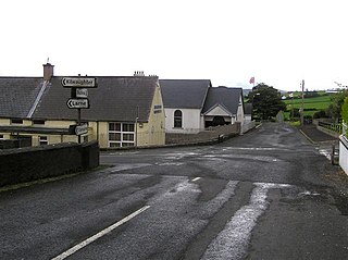
Carnalbanagh is a small village and townland in County Antrim, Northern Ireland, 13 km east-north-east of Ballymena. It is situated in the civil parish of Tickmacrevan and the historic barony of Glenarm Lower, and is part of Mid and East Antrim district. It lies above Glenarm and is close to Mount Slemish.
Solar is a townland of 42 acres in County Antrim, Northern Ireland. It is situated in the civil parish of Carncastle and the historic barony of Glenarm Upper.

Antrim Lower is a barony in County Antrim, Northern Ireland. It is bordered by six other baronies: Antrim Upper to the south; Toome Upper to the south-west; Toome Lower to the west; Kilconway to the north-west; Glenarm Lower to the north-east; and Glenarm Upper to the east. The River Braid flows through this barony.

Glenarm Upper is a barony in County Antrim, Northern Ireland. To its east runs the east-Antrim coast, and it is bordered by four other baronies: Glenarm Lower to the north; Antrim Lower to the west; Antrim Upper to the south-west; and Belfast Lower to the south. Chaine Tower, situated at the entrance to Larne Lough, is located within Glenarm Upper.

Glenarm Lower is a barony in County Antrim, Northern Ireland. To its east runs the east-Antrim coast, and it is bordered by five other baronies: Cary to the north; Dunluce Lower and Kilconway to the west; Antrim Lower to the south-west; and Glenarm Upper to the south-east.

Kilconway is a barony in County Antrim, Northern Ireland. It is bordered by six other baronies: Dunluce Upper to the north; Glenarm Lower to the east; Antrim Lower to the south-east; Toome Lower to the south; Loughinsholin to the south-west; and Coleraine to the north-east. Kilconway also formed part of the medieval territory known as the Route. Springmount Bog is located within the barony.

Ardclinis is a civil parish and townland in County Antrim, Northern Ireland. It is situated in the historic barony of Glenarm Lower.
Aughareamlagh is a townland of 800 acres in County Antrim, Northern Ireland. It is situated approximately 2.6 miles (4.2 km) southwest of Carnlough, in the civil parish of Tickmacrevan and the historic barony of Glenarm Lower. Aughareamlagh was known for its bauxite mining.

Ault,, is a townland of 367 acres in County Antrim, Northern Ireland. It is situated in the civil parish of Tickmacrevan and the historic barony of Glenarm Lower.
Unshinagh Mountain is a townland of 635 acres in County Antrim, Northern Ireland. It is situated in the civil parish of Tickmacrevan and the historic barony of Glenarm Lower.
Upper Broghindrummin is a townland of 186 acres in County Antrim, Northern Ireland. It is situated in the historic barony of Glenarm Lower and the civil parish of Layd.
Burnside is a townland of 38 acres in County Antrim, Northern Ireland. It is situated in the historic barony of Glenarm Lower and the civil parish of Ardclinis.
Layd is a civil parish and townland in County Antrim, Northern Ireland. It is situated in the historic barony of Glenarm Lower.
References
- 1 2 3 "Tickmacrevan". IreAtlas Townlands Database. Retrieved 22 April 2015.
