Layd

Last updated

Layd
County
Country Northern Ireland
Sovereign state United Kingdom
Police Northern Ireland
Fire Northern Ireland
Ambulance Northern Ireland
List of places
UK
Northern Ireland
Antrim

Layd (Irish: Leithead) [1] is a civil parish and townland (of 219 acres) in County Antrim, Northern Ireland. It is situated in the historic barony of Glenarm Lower. [2] [3]

Contents

Civil parish of Layd

The civil parish contains the following villages: [2]

Townlands

The civil parish contains the following townlands: [2] [3]

A

Aganlane (also known as Parkmore), Aghagheigh, Agolagh, Altmore Lower, Altmore Upper

B

Ballyagan, Ballybrack, Ballyfad, Ballymacdoe, Ballynahaville, Ballynalougher, Ballyvooly, Baraghilly, Barard, Bellisk (also known as Waterford)

C

Callisnagh, Carnahagh, Carnanee, Carnasheeran, Cashlan, Clegnagh, Cloghglass (also known as Retreat), Cloghglass, Cloghs, Cloghy East, Cloghy West, Cloney, Corlane, Coshkib, Culbidag

D

Doory, Dromore, Drumcudree, Drumnacur, Drumnasmear, Dunouragan

E

Eagle Hill (also known as Ouna), Ellanabough, Eshcry

F

Fallinerlea, Falmacrilly, Falnaglass, Faughill, Foriff

G

Glasmullen, Glebe, Glenaan, Glenville (also known as Leamore), Gortaclee, Gortaghragan, Gortateean, Gortlane, Gortnagross Lower (also known as Murroo), Gortnagross Middle, Gortnagross Upper (also known as Issbawn), Gruig

I

Issbawn (also known as Upper Gortnagross)

K

Killoughag, Kilmore, Kilnadore, Knockacully, Knockans North, Knockans South, Knockeny, Knocknacarry

L

Lagflugh, Laney, Layd, Leamore (also known as Glenville), Legg, Lubitavish

M

Maghereeroy, Middle Park, Moneyvart, Mount Edwards, Mullarts, Mullinaskeagh, Murroo (also known as Gortnagross Lower)

O

Ouna (also known as Eagle Hill)

P

Parkmore (also known as Aganlane)

R

Rananagh, Red Bay, Retreat (also known as Cloghglass)

S

Savagh, Shaninish, Sleans, Straid

T

Tavnaghan, Tavnagharry, Tavnaghdrissagh, Tavnaghoney, Tavnaghowen, Timpan, Tirkilly, Toberwine, Tromra, Tully

U

Unshanagh

W

Warren, Waterford (also known as Bellisk

Grange of Layd

The Grange of Layd contains the following townlands: Beaghs, Brockaghs, Carnamaddy, Clyttaghan, Dira (also known as Upper Broghindrummin), Drumfresky, Irragh, Kinune, Knocknacrow, Lower Broghindrummin (also known as Tavnaghranny), Tavnaghranny (also known as Lower Broghindrummin), Upper Broghindrummin (also known as Dira)

Layd Church and Churchyard

Layd Church as seen from the south Layd Church 2014 09 18.jpg
Layd Church as seen from the south

The ruins of Layd Church (grid ref:324428), a Franciscan foundation possibly partially from the 13th century, are found 1.5 km north of Cushendall. They are also accessible by a cliff path from Cushendall, as well as by road. There are old vaults in the churchyard and it was one of the main burial places of the MacDonnells. There is a stone cross memorial to Dr James MacDonnell, one of the organisers of the last Belfast Festival of Harpists in 1792 and pioneer of the use of chloroform in surgery. By the gate of the churchyard is a holestone and nearby two 'corp stones' on which coffins were rested. [4] Layd Church saw service as a parish church from 1306 until about 1790. [5] [6]

See also

Related Research Articles

<span class="mw-page-title-main">County Antrim</span> Historic Northern Ireland county

County Antrim is one of the six counties of Northern Ireland, located within the historic province of Ulster. Adjoined to the north-east shore of Lough Neagh, the county covers an area of 3,086 square kilometres (1,192 sq mi) and has a population of 651,321, as of the 2021 census. County Antrim has a population density of 211 people per square kilometre or 546 people per square mile. It is also one of the thirty-two traditional counties of Ireland.

<span class="mw-page-title-main">Glengormley</span> Suburb of Belfast, Northern Ireland

Glengormley is a townland and electoral ward in County Antrim, Northern Ireland. Glengormley is within the urban area of Newtownabbey bordering Belfast, and is located in the Antrim and Newtownabbey Borough Council area. It is also situated in the civil parish of Carnmoney and the historic barony of Belfast Lower.

Glenville is the name of several places.

<span class="mw-page-title-main">Ballintoy</span> Village in County Antrim, Northern Ireland

Ballintoy is a small village, townland and civil parish in County Antrim, Northern Ireland. It is alongside the B15 coast road, 28 km (17 mi) north-east of Coleraine, 8 km (5.0 mi) west of Ballycastle and between it and Bushmills. It is in the historic barony of Cary. The village lies about one kilometre from Ballintoy Harbour, a small fishing harbour at the end of a very small, narrow, steep road down Knocksaughey hill which passes by the entrance to Larrybane and Carrick-a-Rede Rope Bridge. The harbour is host to a dawn service on Easter Sunday each year.

Donegore is the name of a hill, a townland, a small cluster of residences, and a civil parish in the historic barony of Antrim Upper, County Antrim, Northern Ireland. Donegore lies approximately 5 miles (8 km) east of Antrim town. 154 acres of the townland lies in the civil parish of Grange of Nilteen.

<span class="mw-page-title-main">Glenarm</span> Village in County Antrim, Northern Ireland

Glenarm is a village in County Antrim, Northern Ireland. It lies on the North Channel coast north of the town of Larne and the village of Ballygalley, and south of the village of Carnlough. It is situated in the civil parish of Tickmacrevan and the historic barony of Glenarm Lower. It is part of Mid and East Antrim Borough Council and had a population of 568 people in the 2011 Census. Glenarm takes its name from the glen in which it lies, the southernmost of the nine Glens of Antrim.

<span class="mw-page-title-main">Whiteabbey</span> Townland in Northern Ireland, United Kingdom

Whiteabbey is a townland in Newtownabbey, north of Belfast in County Antrim, Northern Ireland.

<span class="mw-page-title-main">Cushendall</span> Village in County Antrim, Northern Ireland

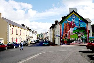
Cushendall, formerly known as Newtownglens, is a coastal village and townland in County Antrim, Northern Ireland. It is located in the historic barony of Glenarm Lower and the civil parish of Layd, and is part of Causeway Coast and Glens district.

<span class="mw-page-title-main">Knocknacarry</span> Hamlet in County Antrim, Northern Ireland

Knocknacarry is a hamlet and townland about 1 kilometre west of Cushendun and 17 kilometres south-east of Ballycastle in County Antrim, Northern Ireland. It is situated in the historic barony of Glenarm Lower and the civil parish of Layd. In the 2001 Census it had a population of 138 people. It is within the Causeway Coast and Glens Borough Council area.

<span class="mw-page-title-main">Upper Ballinderry</span> Village in County Antrim, Northern Ireland

Upper Ballinderry is a small village to the east of Lower Ballinderry in County Antrim, Northern Ireland. It is within the townland of Ballyscolly and civil parish of Ballinderry, the historic barony of Massereene Upper. Upper Ballinderry is about 10 miles (15 km) north- west of Lisburn. In the 2001 Census it had a population of 192 people.

Ballyvoy is a small village and townland in County Antrim, Northern Ireland. It is on the main A2 coast road 5 km east of Ballycastle and 17 km north west of Cushendall. In the 2001 Census it had a population of 72 people. It lies within the Antrim Coast and Glens Area of Outstanding Natural Beauty and is part of Causeway Coast and Glens District Council.

<span class="mw-page-title-main">Ardclinis</span> Parish in County Antrim, Northern Ireland

Ardclinis is a civil parish and townland in County Antrim, Northern Ireland. It is situated in the historic barony of Glenarm Lower.

Upper Broghindrummin is a townland of 186 acres in County Antrim, Northern Ireland. It is situated in the historic barony of Glenarm Lower and the civil parish of Layd.

<span class="mw-page-title-main">Ards Upper</span> Place in Northern Ireland, United Kingdom

Ards Upper is a barony in County Down, Northern Ireland. It lies on the southern half of the Ards Peninsula in the east of the county, with the Irish Sea to its east and Strangford Lough to its west. It is bordered by two other baronies: Ards Lower to the north; and Lecale Lower just across the mouth of Strangford Lough to the south.

Finvoy is a hamlet and civil parish in County Antrim, Northern Ireland. It is situated in the historic barony of Kilconway. The hamlet had a population of 187 people in the 2011 Census.

<span class="mw-page-title-main">Derriaghy</span> Human settlement in Northern Ireland

Derriaghy,, , is a townland and civil parish in County Antrim, Northern Ireland, 5.5 miles (9 km) south-west of Belfast city centre. The townland is situated in the historic barony of Belfast Upper and the civil parish covers areas of both Belfast Upper and the barony of Massereene Upper.

<span class="mw-page-title-main">Blaris</span> Human settlement in Northern Ireland

Blaris is a civil parish covering areas of both County Antrim and County Down, Northern Ireland. It is situated in the historic baronies of Castlereagh Upper and Iveagh Lower, Upper Half in County Down and Massereene Upper in County Antrim. It is also a townland of 543 acres, which contains the site of the Blaris medieval parish church, and is on the south-east side of the River Lagan, adjacent to Lisburn.

Kilclief is a civil parish in County Down, Northern Ireland. It is situated in the historic baronies of Lecale Lower and Lecale Upper. It is also a townland of 623 acres.

References

  1. "Leithead/Layd". logainm.ie. Retrieved 9 December 2023.
  2. 1 2 3 "Layd". IreAtlas Townlands Database. Retrieved 12 April 2015.
  3. 1 2 "Layd". Placenames Database of Ireland. Retrieved 12 April 2015.
  4. Sandford, Ernest (1976). Discover Northern Ireland. Belfast: Northern Ireland Tourist Board. pp. 62–63. ISBN   0 9500222 7 6.
  5. "Layd Church". Walk NI. Retrieved 13 April 2015.
  6. "Layd Church Yard". Cushendall.info. Retrieved 13 April 2015.