Linear park

Last updated
Promenade Plantee, a 4.7 km (2.9 mi) elevated linear park built on top of obsolete railway infrastructure in the 12th arrondissement of Paris, France. PromenadePlantee.jpg
Promenade Plantée, a 4.7 km (2.9 mi) elevated linear park built on top of obsolete railway infrastructure in the 12th arrondissement of Paris, France.
Plan of the Emerald Necklace, Boston, US, in 1894 Olmsted plan for the Emerald Necklace, 1894.jpg
Plan of the Emerald Necklace, Boston, US, in 1894

A linear park is a type of park that is significantly longer than it is wide. [lower-alpha 1] [ full citation needed ] These linear parks are strips of public land running along canals, rivers, streams, defensive walls, electrical lines, or highways [1] and shorelines. [2] Examples of linear parks include everything from wildlife corridors to riverways to trails, capturing the broadest sense of the word. [3] Other examples include rail trails ("rails to trails"), which are disused railroad beds converted for recreational use by removing existing structures. Commonly, these linear parks result from the public and private sectors acting on the dense urban need for open green space. [4] Linear parks stretch through urban areas, coming through as a solution for the lack of space and need for urban greenery. They also effectively connect different neighborhoods in dense urban areas as a result, and create places that are ideal for activities such as jogging or walking. [5] Linear parks may also be categorized as greenways. [6] [7] In Australia, a linear park along the coast is known as a foreshoreway. When being designed, linear parks appear unique as they are planned around the public's opinion of how the space will affect them. [8]

Contents

North America

Possibly the earliest example is the Emerald Necklace, which consists of a 1,100-acre (4.5 km2), or 445 hectare chain of parks linked by parkways (a broad, landscaped highway) [9] and waterways in Boston and Brookline, Massachusetts, U.S. The name comes from the way the planned chain appears to hang from the "neck" of the Boston peninsula. [10] This system of linear parks was designed by Frederick Law Olmsted to connect the Boston Common and Public Garden (1837) to Franklin Park (Boston), also known as the "crown jewel" of Olmstead's work in Boston. [11] The project began around 1878 with efforts to clean up and control the marshy area which later became the Back Bay and the Fens. In 1880, Olmsted proposed that the Muddy River be included in the park plan as the current dredged into a winding stream and was directed into the Charles River. Olmsted's vision of a linear park of walking paths along a gentle stream connecting numerous small ponds was complete by the turn of the century, but never completed the section to Boston Harbor. The subsequent development of the automobile industry and roads severely disrupted the original concept. [12]

High Line Park, New York City, US an aerial greenway, modelled on Paris's Promenade plantee High Line 20th Street looking downtown.jpg
High Line Park, New York City, US an aerial greenway, modelled on Paris's Promenade plantée

In recent years, prevalent examples of linear parks that have seen high levels of visitors are the High Line in New York City and the Bloomingdale Trail in Chicago. The High Line in New York City is a 1.4 mile (2.2 km) long rail trail and greenway, having been built on a portion of a defunct rail line as well as constructed to have greenery all throughout. [14] Like its Paris counterpart Promenade Plantee, the High Line has been transformed into a linear park that allows for activities such as sight-seeing and exercise, while being elevated. The High Line's annual budget is funded almost entirely by park visitors, though it is operated by the New York City Department of Parks and Recreation license agreement. [15] Bloomingdale Trail in Chicago is the longest linear park in the Western Hemisphere, and the second-longest linear park in the world, with a length of 2.7 miles (4.3 km), just under Paris' Promenade Plantee at 2.9 miles (4.6 km). Bloomingdale Trial was created by converting an elevated portion of the former Bloomingdale railway to this linear park, which features trees, flowers, plants, shrubbery, grass, light posts, and benches throughout. The greenway transverses through the neighborhoods of Logan Square, Humboldt Park, and West Town.

William Sarjeant Park, a linear park in the Willowgrove neighborhood of Saskatoon, Saskatchewan, Canada William Sarjeant Park.jpg
William Sarjeant Park, a linear park in the Willowgrove neighborhood of Saskatoon, Saskatchewan, Canada

In some cities, many linear parks run through residential areas. In this case, the front of the house will face the streets, while the back faces a small linear park containing a pathway, trees and grass connecting different areas together. There are examples of this in some US cities and some Canadian cities, such as Saskatoon, Canada. [16] Houses connected with linear parks are more common in suburban and rural areas where space is much less in-demand.

Unique art found in BeltLine, Atlanta. Beltline Artwork.jpg
Unique art found in BeltLine, Atlanta.

Atlanta BeltLine

A linear park system under development in Atlanta, Georgia is the BeltLine. Part of the foundation for this project consisted of reclaiming 22 miles (35 km) of unused rail trails. Totaling approximately 33 miles (53 km), the BeltLine will include a trail and light rail line on the existing tracks instead of a road. [17] The vision of the BeltLine is to attempt to balance out resident demographics within the city, allowing for all associated to the BeltLine to benefit. [18]


Europe

Part of one of Milton Keynes's linear parks, showing cyclists crossing a cattle grid on National Cycle Route 51 NCR 51 MiltonKeynes east.JPG
Part of one of Milton Keynes's linear parks, showing cyclists crossing a cattle grid on National Cycle Route 51

In England, linear parks have also been created around waterways, especially in cities where the terrain is such that rivers and brooks have significant flood plains. Such land cannot sensibly be used for urban development and so it is set aside as a civic amenity. The settlement Milton Keynes makes extensive use of linear parks, with nine different examples that include the flood plains of the Great Ouse and of its tributaries (the Ouzel and some brooks). [19] [20] [21] In the UK, Milton Keynes ranked highest in a national comparison of open urban areas available to residents. [22]

In Greater London, Essex and Hertfordshire, the Lee Valley Park is a 10,000-acre (40 km2) linear park, stretching for 26 miles (42 km) long, much of it green spaces running along the flood plains of the River Lea from the River Thames to Ware, through areas such as Stratford, Clapton, Tottenham, Enfield, Walthamstow, Cheshunt, Broxbourne and Hoddesdon in an area renowned as the Lea Valley. Greater London's largest park, Lee Valley Park is more than four times the size of Richmond Park, extending beyond Greater London's borders into the neighboring counties of Hertfordshire and Essex.

Mauerpark in Berlin, Germany Mauerpark 1979.jpg
Mauerpark in Berlin, Germany

A more recent example of a linear park is the Berlin Mauerpark, which was built on a part of the former Berlin Wall area and its adjacent former death strip.

Planty Park, Kraków, Poland). It encircles the Stare Miasto (Old Town), where the Medieval city walls used to stand until the early 19th century. The park has an area of 21 ha (52 acres) and a length of 4 km (2.5 mi). [23] It consists of a chain of thirty smaller gardens designed in varied styles and adorned with numerous monuments and fountains. The park forms a scenic walkway popular with Cracovians. In summer, sprinkled with ponds and refreshment stalls, it is a cool and shady retreat from the nearby bustling streets. [24]

Asia

View of the walkway(Avenue of Stars, Hong Kong) Avenue of Stars 201901.jpg
View of the walkway(Avenue of Stars, Hong Kong)

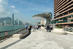
In Hong Kong, a prominent example of a linear park is the Avenue of Stars. Located at the waterfront surrounding East Tsim Sha Tsui, the Avenue of Stars is a 440-meter(0.27 mi.) promenade offering scenic views to the public. As a public amenity, the park provides much needed urban space to the dense city of Hong Kong. The walking road itself is dedicated to famous Hong Kong celebrities, and as such is an attractive tourist area lined with souvenir stalls at some sections. [25]

In addition to the dynamic waterfront location, the Avenue of Stars provides visitors a "front-row seat"(stand) to the Symphony of Lights, the world's largest light and sound show. It is also around this area that the famed Star Ferry can be observed and even ridden.

Picture of Rail Corridor, Singapore Rail corridor, The rail can run anywhere (expressways) - Flickr - GeorgeTan^3.jpg
Picture of Rail Corridor, Singapore

In Singapore, wild growth and shrubbery that's taken over a former KTM rail line has been encouraged and maintained through public opinion. Convincing the Singaporean government of the land's value, the citizens of Singapore were able to turn a neglected KTM railway in to a linear park that now runs 10 km(6.21 mi) long and offers unique perspectives into Singaporean wildlife. Rail Corridor differs from the typical linear park in a way that promotes and integrates the biodiversity and ecosystem throughout—covering 93 [26] different species—while serving as an excellent outdoor trail to get active in. [27]


List of linear parks

Europe

Belgium

France

Germany

Ireland

Portugal

Spain

United Kingdom

North America

Canada

United States

Mexico

South America

Brazil

Asia

Hong Kong

Singapore

  • Rail Corridor, Singapore

Iran

Israel

Japan

Philippines

Taiwan

South Korea

United Arab Emirates

Australia

See also

Notes

  1. There is no dictionary definition for the term in the full Oxford Dictionary of English. "Linear: Resembling a line; very narrow in proportion to its length, and of uniform breadth." (Oxford Dictionary of English) The term linear park seems to have begun to be used on a regular basis in the 1960s (Google Ngram Viewer). The earliest usage in Britain was in reference to the idea of a River Thames "linear national park", in Time on the Thames by Eric Samuel De Maré (Architectural Press, 1952) (Ngram). Google Ngram Viewer, however, indicates a few earlier examples, including from the US in 1939 (Supplementary report of the Urbanism Committee to the National Resources Committee, Volume 2. United States. National Resources Committee. Research Committee on Urbanism. Clarence Addison Dykstra. U.S. Govt. 1939). It may also have been used in 1873, but Ngram didn't provide the source(s).

Related Research Articles

<span class="mw-page-title-main">East Coast Greenway</span> Long-distance hiking trail in the United States

The East Coast Greenway is a 3,000-mile (4,800 km) pedestrian and bicycle route between Maine and Florida along the East Coast of the United States. The nonprofit East Coast Greenway Alliance was created in 1991 with the goal to use the entire route with off-road, shared-use paths; as of 2021, over 1,000 mi (1,600 km) of the route (35%) meets this criteria. In 2020, the Greenway received over 50 million visits.

<span class="mw-page-title-main">Rail trail</span> Railroad bed converted to a recreational trail

A rail trail is a shared-use path on railway right of way. Rail trails are typically constructed after a railway has been abandoned and the track has been removed but may also share the right of way with active railways, light rail, or streetcars, or with disused track. As shared-use paths, rail trails are primarily for non-motorized traffic including pedestrians, bicycles, horseback riders, skaters, and cross-country skiers, although snowmobiles and ATVs may be allowed. The characteristics of abandoned railways—gentle grades, well-engineered rights of way and structures, and passage through historical areas—lend themselves to rail trails and account for their popularity. Many rail trails are long-distance trails, while some shorter rail trails are known as greenways or linear parks.

<span title="French-language text"><i lang="fr">Coulée verte René-Dumont</i></span> Parisian elevated promenade

The Coulée verte René-Dumont or Promenade plantée René-Dumont is a 4.7 km (2.9 mi) elevated linear park built on top of obsolete railway infrastructure in the 12th arrondissement of Paris, France. It was inaugurated in 1993.

<span class="mw-page-title-main">Alewife Brook Reservation</span> State park and reservation in Massachusetts, USA

Alewife Brook Reservation is a Massachusetts state park and urban wild located in Cambridge, Arlington, and Somerville. The park is managed by the state Department of Conservation and Recreation and was established in 1900. It is named for Alewife Brook, which was also historically known as Menotomy River, a tributary of the Mystic River.

<span class="mw-page-title-main">Bloomingdale Trail</span> Elevated rail trail in Chicago

The Bloomingdale Trail is a 2.7-mile (4.3 km) elevated rail trail linear park running east–west on the northwest side of Chicago. It is the longest greenway project of a former elevated rail line in the Western Hemisphere, and the second longest in the world, after the Promenade plantee linear park in Paris. In 2015, the City of Chicago converted the former Bloomingdale railway line to an elevated greenway, which forms the backbone of the 606 trail network. The Bloomingdale Trail elevated park is in the Logan Square, Humboldt Park, and West Town community areas.

<span class="mw-page-title-main">Midtown Greenway</span> Shared-use path in Minneapolis, USA

The Midtown Greenway is a 5.7-mile (9.2 km) rail trail in Minneapolis, Minnesota that follows the path of an abandoned route of the Milwaukee Road railway. It is considered under segregated cycle facilities.

<span class="mw-page-title-main">Greenway (landscape)</span> Shared-use path or linear park with vegetation

A greenway is usually a shared-use path along a strip of undeveloped land, in an urban or rural area, set aside for recreational use or environmental protection. Greenways are frequently created out of disused railways, canal towpaths, utility company rights of way, or derelict industrial land. Greenways can also be linear parks, and can serve as wildlife corridors. The path's surface may be paved and often serves multiple users: walkers, runners, bicyclists, skaters and hikers. A characteristic of greenways, as defined by the European Greenways Association, is "ease of passage": that is that they have "either low or zero gradient", so that they can be used by all "types of users, including mobility impaired people".

<span class="mw-page-title-main">National Register of Historic Places listings in Massachusetts</span>

The National Register of Historic Places is a United States federal official list of places and sites considered worthy of preservation. In the state of Massachusetts, there are over 4,300 listings, representing about 5% of all NRHP listings nationwide and the second-most of any U.S. state, behind only New York. Listings appear in all 14 Massachusetts counties.

<span class="mw-page-title-main">Hackensack River Greenway</span> Trail along the lower Hackensack River

Hackensack River Greenway, once known as the Hackensack RiverWalk, a is partially constructed greenway along the Newark Bay and Hackensack River in Hudson County, New Jersey, United States.

<span class="mw-page-title-main">East Bay Bike Path</span> Multi-use trail in Rhode Island

The East Bay Bike Path is a 14.5-mile (23.3 km) paved rail trail in Rhode Island. The path begins in Providence and India Point Park, crosses the Seekonk River via the George Redman Linear Park and Washington Bridge and continues southeast to Bristol along the shoreline of Narragansett Bay. The path passes through the city of East Providence, the hamlet of Riverside, and the towns of Barrington and Warren. It is part of the East Coast Greenway, a 3,000-mile system of trails connecting the Canada–US border in Maine to Key West. and provides access to Haines State Park, Brickyard Pond (Barrington), and Colt State Park. It is used annually by 1.1 million people.

<span class="mw-page-title-main">Capitol View, Atlanta</span>

Capitol View is a historic in-town southwest Atlanta neighborhood 2.5 miles from downtown Atlanta, Georgia that was named for its view of the Georgia State Capitol building. Its boundaries include Metropolitan Parkway to the east, Lee Street to the west, and the Beltline to the north. On the south, the border follows Arden Street, Deckner Avenue, and Perkerson Park.

Commonwealth Connections is a greenway and conservation initiative co-developed by the Commonwealth of Massachusetts Department of Conservation and Recreation (DCR), the National Park Service, and over fifty trail and land conservation agencies and non-profit organizations. Begun in 1999, the initiative was designed to create "a coordinated greenway and trail network that will help conserve important resources, provide recreation and alternative transportation opportunities close to where people live, and connect communities throughout Massachusetts."

<span class="mw-page-title-main">Watertown Branch Railroad</span> Former rail right of way being converted to multi use path

The Watertown Branch Railroad was a branch loop of the Fitchburg Railroad that was meant to serve the town of Watertown and the City of Waltham, Middlesex County, Massachusetts, as an independent short line railroad; it also serviced the Watertown Arsenal. The line has been formally abandoned and portions have been converted into a rail trail, the Watertown-Cambridge Greenway. A section from School Street to Arlington Street in Watertown was completed first. A small portion in Waltham has been converted into a park called Chemistry Station Park after the railroad station once located there. Construction of an extension to Fresh Pond Reservation in Cambridge began in the summer of 2018 and was completed in June 2022.

<span class="mw-page-title-main">Elevated park</span> Parks located above the normal ground (street) level

An elevated park refers to a park located above the normal ground (street) level. This type of a park has become more popular in the early 21st century, featuring in a number of urban renewal projects. While usually associated with repurposed transportation infrastructure, some elevated parks are designed on top of buildings.

<span class="mw-page-title-main">Hiawatha LRT Trail</span> Shared-use path in Minneapolis

Hiawatha LRT Trail is a 4.7-mile (7.6 km), multi-use path adjacent to a light-rail transit line in Minneapolis, Minnesota, United States, that is popular with bicycle commuters. Users travel along the Metro Blue Line and Hiawatha Avenue transit corridor, reaching downtown Minneapolis near an indoor sports stadium at the trail’s northern end, and reaching a bridge above Minnehaha Creek at the trail’s southern end. Hiawatha LRT Trail provides a vital link between several Minneapolis neighborhoods and the city’s downtown area.

<span class="mw-page-title-main">Min Hi Line</span> Proposed linear park and shared-use path in Minneapolis

Min Hi Line is a proposed linear park and shared-use path that would eventually re-purpose an active rail and agri-industrial corridor in the Longfellow community of Minneapolis, Minnesota, United States. Modeled after successful projects like the Atlanta Beltline and New York High Line, it would feature an approximately 3-mile (4.8 km), shared-use pathway that traverses housing, retail, commercial buildings, gardens, playgrounds, and public art installments. Two pilot projects completed in 2018 and 2019 connect the Min Hi Line corridor to trail systems at its northern and southern ends.

<span class="mw-page-title-main">Essex–Hudson Greenway</span>

The Essex–Hudson Greenway is planned state park and greenway in the northerneastern New Jersey counties of Essex and Hudson. It will follow an abandoned railroad right of way (ROW) across the New Jersey Meadowlands, over the Hackensack and Passaic rivers, as well pass through densely-populated neighborhoods. The nearly 9-mile (14 km) long shared-use linear park/rail trail will encompass about 135 acres (55 ha) and will average 100 feet (30 m) in width. Running between Jersey City and Montclair it will pass through Secaucus, Arlington in northern Kearny, North Newark, Belleville, Bloomfield and Glen Ridge. The initial phase in Newark and Kearny is expected to open in late 2025

References

  1. "Parks and Recreation Programming Master Plan" (PDF). Hurst, Tx City Council. Archived from the original (PDF) on 2007-10-07. Retrieved 2009-04-06.
  2. "Study Trail profiles". U.S. Department of Transport Federal Highway Administration. Archived from the original on 2009-05-10. Retrieved 2009-04-06.
  3. Conference, International Linear Parks (1987). "Parkways". www.jstor.org. doi:10.2307/j.ctt1xp3kv8. JSTOR   j.ctt1xp3kv8 . Retrieved 2021-12-06.
  4. Faggi, Ana (2017-01-18). "Linear Parks: The Importance of a Balanced, Cross-Disciplinary Design". The Nature of Cities. Retrieved 2021-12-07.
  5. "6 Types of Linear Park". Simplicable. Retrieved 2021-12-07.
  6. Truman Greenway, Savannah, Georgia, US
  7. City of Kelowna, British Columbia, Canada
  8. Faggi, Ana (2017-01-18). "Linear Parks: The Importance of a Balanced, Cross-Disciplinary Design". The Nature of Cities. Retrieved 2021-12-08.
  9. "parkway."Webster's Third New International Dictionary, Unabridged. Merriam-Webster, 2002. http://unabridged.merriam-webster.com (14 Apr. 2007).
  10. Emerald Necklace Greenway
  11. "The Emerald Necklace Conservancy". 2007-08-30. Archived from the original on 2007-08-30. Retrieved 2021-12-07.
  12. Emerald Necklace Greenway
  13. "Paris Elevated Rail Park Featured in Movie 'Before Sunset'". Friends of the High Line. August 12, 2004. Archived from the original on October 23, 2014. Retrieved July 27, 2014.
  14. "Overview". The High Line. Retrieved 2021-12-07.
  15. "History". The High Line. Retrieved 2021-12-07.
  16. "City of Saskatoon". Archived from the original on 2014-11-13. Retrieved 2014-11-16.
  17. "Home". Atlanta Beltline. Retrieved 2021-12-07.
  18. "Equity and Inclusion". Atlanta Beltline. Retrieved 2021-12-07.
  19. Ouse Valley Park [ permanent dead link ] - Milton Keynes Parks Trust
  20. Ouzel Valley Park Archived 2021-02-01 at the Wayback Machine - Milton Keynes Parks Trust
  21. "Parks Trust Milton Keynes". Archived from the original on 2021-01-16. Retrieved 2014-11-16.
  22. "Milton Keynes ranks top for green space". www.miltonkeynes.co.uk. Retrieved 2021-12-07.
  23. "Planty Garden Ring". Kraków Travel. Retrieved 28 February 2022.
  24. Andrew Beattie, From the Piast Church to the Holy Cross Church Landmark Publishing, page 40.
  25. "About AOS | the Avenue of Stars | Harbour, Now Sparkling". the Avenue of Stars. Retrieved 2021-12-07.
  26. "Rail Corridor". www.nparks.gov.sg. Retrieved 2021-12-08.
  27. "The Rail Corridor : State of Buildings". stateofbuildings.sg. Retrieved 2021-12-08.
  28. "James River Park System, Richmond, Virginia". Archived from the original on 2021-03-27. Retrieved 2014-03-15.
  29. District 4 News - January 22, 2015 (Commissioner Bill Ganz)
  30. New York State Parks, Recreation and Historic Preservation: Walkway over the Hudson State Historic Park