
Adelaide Metro is the public transport system of the Adelaide area, around the capital city of South Australia. It is an intermodal system offering an integrated network of bus, tram, and train services throughout the metropolitan area. The network has an annual patronage of 79.9 million, of which 51 million journeys are by bus, 15.6 million by train, and 9.4 million by tram. The system has evolved heavily over the past fifteen years, and patronage increased dramatically during the 2014–15 period, a 5.5 percent increase on the 2013 figures due to electrification of frequented lines.

The River Torrens is the most significant river of the Adelaide Plains. It was one of the main reasons for the siting of the city of Adelaide, capital of South Australia. It flows 85 kilometres (53 mi) from its source in the Adelaide Hills near Mount Pleasant, across the Adelaide Plains, past the city centre and empties into Gulf St Vincent between Henley Beach South and West Beach. The upper stretches of the river and the reservoirs in its watershed supply a significant part of the city's water supply.

The O-Bahn Busway is a guided busway that is part of the bus rapid transit system servicing the northeastern suburbs of Adelaide, South Australia. The O-Bahn system was conceived by Daimler-Benz to enable buses to avoid traffic congestion by sharing tram tunnels in the German city of Essen.

Cudlee Creek is a small town near Adelaide, South Australia. It is located in the Adelaide Hills Council local government area.
The Mawson Trail is a long-distance cycling and walking trail in South Australia starting just east of Adelaide in the Adelaide Hills and extending almost 900 kilometres (560 mi) to Blinman in the Flinders Ranges. It is suitable for mountain bikes.

Greenwith is an outer-north-eastern suburb of Adelaide, the capital city of South Australia, and is within the City of Tea Tree Gully local government area. It is adjacent to Golden Grove and Salisbury Heights. Greenwith is the northernmost part of the Golden Grove urban land development.

Athelstone is a suburb of Adelaide in the City of Campbelltown. It was established in the 19th century but only became part of suburban Adelaide in the second half of the 20th century.

Hackney is an inner-eastern suburb of Adelaide, South Australia, in the City of Norwood Payneham St Peters. It is adjacent to the Adelaide Park Lands, the Adelaide city centre and North Adelaide. The O-Bahn Busway passes along Hackney Road, part of the City Ring Route, which forms its western boundary. Its other boundaries are the River Torrens (north), the continuation of North Terrace through Kent Town (south), and a series of small streets and lanes to the east.
Joslin is a suburb of Adelaide in the City of Norwood Payneham St Peters. It is rectangular, stretching from Payneham Road (southeast) to the River Torrens and Torrens Linear Park (northwest), but from Lambert Road on the northeast only about 350m along the numbered avenues towards the next cross street which is in St Peters.

Paradise is a northeastern suburb of Adelaide in South Australia. It is bounded on the north side by the River Torrens. Amongst its neighbouring suburbs are Highbury, Dernancourt, Athelstone, Newton and Campbelltown.
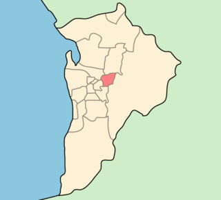
The City of Campbelltown is a local government area in the inner eastern suburbs of Adelaide, South Australia about 6 kilometres from the Adelaide GPO. The city is bordered by the River Torrens and the City of Tea Tree Gully, the District of Adelaide Hills, the City of Burnside, the City of Norwood Payneham St Peters, and the City of Port Adelaide Enfield.

The metropolitan area of Adelaide, South Australia is served by a wide variety of transport. Being centrally located on the Australian mainland, it forms a hub for east–west and north–south routes. The road network includes major expressways such as the Southern Expressway, the South Eastern Freeway, the Port River Expressway, the Northern Expressway and the South Road Superway. The city also has a public transport system managed by Adelaide Metro, consisting of a contracted bus system including the O-Bahn Busway, six metropolitan railway lines, and the Glenelg-Adelaide-Hindmarsh Tram. According to a study conducted by the Australian Bureau of Statistics, Adelaide has the highest passenger vehicle travel to work (84%) and the second lowest proportion of people walking to work (2.9%)–something that is being combated by the South Australian government in an effort to increase citizen ridership and use of public transport.

The Metropolitan Adelaide Transport Study, or "MATS Plan" as it became known, was a comprehensive transport plan released in 1968 proposing a number of road and rail transport projects for the metropolitan area of Adelaide, South Australia.
Adelaide–Mannum Road is a road that runs through the northern Adelaide Hills between the South Australian capital, Adelaide and Mannum on the Murray River. It is designated route A10 in the metropolitan area and B10 in rural areas, and is 79 kilometres in length. This name covers many consecutive streets and is not widely known to most drivers, as the entire allocation is still best known as by the names of its constituent parts: Northcote Terrace, North East Road, Torrens Valley Road, Randell Road and Adelaide Road. This article will deal with the entire length of the corridor for sake of completion, as well to avoid confusion between declarations.

Klemzig is a suburb of Adelaide in the City of Port Adelaide Enfield. It was the first settlement of German immigrants in Australia and was named after the village of Klemzig in what was then German Prussia and is now Klępsk in western Poland.

The Little Para River is a seasonal creek running across the Adelaide Plains in the Australian state of South Australia, whose catchment fills reservoirs that supply some of the water needs of Adelaide’s northern suburbs.

Fulham is a western suburb of Adelaide, South Australia. It is located in the City of West Torrens.

Buses in Adelaide are the most extensive service of the South Australian capital's public transport system, the Adelaide Metro. A large fleet of diesel, hybrid diesel-electric, and natural gas powered buses operate services which typically terminate in the city-centre or at a suburban interchange. Buses get priority on many roads and intersections, with dedicated bus lanes and 'B'-light bus only phases at many traffic lights.
Highbury is a suburb of Adelaide South Australia in the City of Tea Tree Gully in the Adelaide foothills. It is eastwardly adjacent to the suburbs of Hope Valley and Dernancourt. The River Torrens forms southern border of the suburb, with the suburbs of Paradise and Athelstone lying adjacent across the river. The eastern end of the suburb lies in the Adelaide Hills Face Zone
The Sturt River, also known as the Sturt Creek and Warri Parri (Warriparri) in the Kaurna language, is a river located in the Adelaide region of the Australian state of South Australia.
