Henley Beach, South Australia

Last updated

Henley Beach
Adelaide,  South Australia
Henlye-Beach-pier-2108.jpg
Henley Beach jetty
Population6,259 (SAL 2021) [1]
Establishedc. 1860 [2]
Postcode(s) 5022 [3]
Area2.5 km2 (1.0 sq mi)
Location9.7 km (6 mi) W of Adelaide city centre [3]
LGA(s) City of Charles Sturt [4]
State electorate(s) Colton (2011) [5]
Federal division(s) Hindmarsh (2011) [6]
Suburbs around Henley Beach:
Grange Grange
Gulf St Vincent Henley Beach Fulham Gardens
Henley Beach South Fulham
Dusk at Henley Beach South Henley Beach South sunset.jpg
Dusk at Henley Beach South
Henley Beach at Henley Beach Henley-Beach-helicopter-2099.jpg
Henley Beach at Henley Beach

Henley Beach is a coastal suburb of Adelaide, South Australia in the City of Charles Sturt.

Contents

History

Henley Beach was named for the English town of Henley-on-Thames, the home town of Sir Charles Cooper, South Australia's first judge. Cooper had a residence in the area adjacent Charles Sturt's property "The Grange", for which Grange Beach was named. It has been asserted that Sturt's suggestion of "Cooper's Beach" was rejected by Cooper, who gave it the current name. [7]

The Town of Henley Beach was promoted in the South Australian Register in 1860 as being "free from all the noxious smells which have been cause of complaint elsewhere". [2] The Register again advertised the township in 1874: [2]

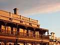
While admitted to be one of the finest in the colony, [it] has been somewhat neglected owing to the road not being made. The District Council and private enterprise, however, have overcome this...

The Manning Index of South Australian History

Geography

Henley Beach lies between the suburbs of West Beach and Grange.

Demographics

The 2021 Census by the Australian Bureau of Statistics counted 6,259 persons in Henley Beach on census night. Of these, 49.4% were male and 50.6% were female. [8]

Aboriginal and Torres Strait Islander people make up 1.1% of the population. The most common ancestries in Woodville West were English (39.4%), Australian (31.7%), Irish (10.7%), Italian (10.6%) and Scottish (9.2%). The majority of residents (77.3%) are of Australian birth, with a further 5.7% identifying England as their country of origin. The most common religious affiliations in Woodville West were No Religion (43.3%), Catholic (26%), Anglican (7.9%), Eastern Orthodox (4.5%) and Uniting Church (4.3%). [8]

85.5% of the population stated they only speak English at home. The next most common languages were Greek (2.5%), Italian (1.9%) and Serbian, Afrikaans and Portuguese (0.5% each). [8]

Governance

Local government

Henley Beach is part of Henley Ward in the City of Charles Sturt local government area, being represented in that council by Kenzie Van den Nieuwelaar and Paul Sykes. [4] It was part of the Henley & Grange Council from 1915 until the merger with the City of Hindmarsh Woodville to create the City of Charles Sturt on 1 January 1997. [9] [10]

State and federal

Henley Beach lies in the state electoral district of Colton [5] and the federal electoral division of Hindmarsh. [6] The suburb is represented in the South Australian House of Assembly by Paul Caica [5] and federally by Steve Georganas.

Schools

There are several schools in the suburb, including: Fulham Gardens Primary School, Fulham North Primary School, Henley High School, St Michael's College, Henley Beach Primary school, and Star of the Sea School

Parks

Henley Square is located behind Henley Jetty on the Esplanade. Other greenspace in the suburb is the Henley Grange Memorial Oval and John Mitchell Oval. Henley Beach extends the length of the suburb.

Transport

Henley Beach is serviced by Grange Road and Henley Beach Road, both connecting the suburb to Adelaide City Centre. Seaview Road runs along the coast.

Henley Beach is serviced by public transport run by the Adelaide Metro which provides bus services to the Adelaide city centre and Glenelg. The Grange railway line was extended to Henley Beach as the Henley Beach railway line in 1894 and the extension closed in 1957. There was a tram line from the city centre to Henley Beach. This was initially a horse-drawn tram, converted to electricity in the 1920s and ceased operation in the 1950s along with almost every other tram line in Adelaide.

See also

Related Research Articles

<span class="mw-page-title-main">Grange, South Australia</span> Suburb of Adelaide, South Australia

Grange is a coastal suburb of the City of Charles Sturt, in Adelaide, South Australia, located about 11 kilometres (6.8 mi) from the Adelaide city centre. The suburb is named after Captain Charles Sturt's cottage, built in 1840–41, which still stands and is now a museum. In addition to Grange Beach, the suburb has several parks and reserves, as well as the Grange Hotel, which was originally licensed in 1881.

<span class="mw-page-title-main">City of Charles Sturt</span> Local government area in South Australia

The City of Charles Sturt is a local government area in the western suburbs of Adelaide, South Australia, stretching to the coast.

<span class="mw-page-title-main">Flinders Park, South Australia</span> Suburb of Adelaide, South Australia

Flinders Park is a western suburb of Adelaide, South Australia. It is located in the City of Charles Sturt.

<span class="mw-page-title-main">Cheltenham, South Australia</span> Suburb of Adelaide, South Australia

Cheltenham is a suburb of Adelaide, South Australia. It is located on Kaurna Land in the City of Charles Sturt.

<span class="mw-page-title-main">Bowden, South Australia</span> Suburb of Adelaide, South Australia

Bowden is an inner northern suburb of Adelaide, South Australia. It is located in the City of Charles Sturt.

Fulham Gardens is a western suburb of Adelaide, South Australia in the City of Charles Sturt.

Kidman Park is a western suburb of Adelaide, South Australia. It is located in the City of Charles Sturt.

Albert Park is a suburb of Adelaide, South Australia. It is located in the City of Charles Sturt.

<span class="mw-page-title-main">Kilkenny, South Australia</span> Suburb of Adelaide, South Australia

Kilkenny is an inner north-western suburb of Adelaide, South Australia. It is located in the City of Charles Sturt. It is named after Kilkenny, Ireland.

<span class="mw-page-title-main">Hindmarsh, South Australia</span> Suburb of Adelaide, South Australia

Hindmarsh is an inner suburb of Adelaide, South Australia. It is located in the City of Charles Sturt.

Findon is a western suburb of Adelaide, South Australia. It is located in the City of Charles Sturt.

<span class="mw-page-title-main">Henley Beach South, South Australia</span> Suburb of Adelaide, South Australia

Henley Beach South is a coastal suburb of Adelaide, South Australia. It is located in the City of Charles Sturt.

<span class="mw-page-title-main">Croydon, South Australia</span> Suburb of Adelaide, South Australia

Croydon is an inner western suburb of Adelaide, South Australia. It is located in the City of Charles Sturt.

<span class="mw-page-title-main">Beverley, South Australia</span> Suburb of Adelaide, South Australia

Beverley is a western suburb of Adelaide, South Australia. It is located in the City of Charles Sturt.

Hendon is a north-western suburb of Adelaide, South Australia, 9.8 km from the Adelaide city centre. It is located in the City of Charles Sturt.

<span class="mw-page-title-main">West Hindmarsh, South Australia</span> Suburb of Adelaide, South Australia

West Hindmarsh is a suburb of Adelaide, located in the City of Charles Sturt local government area. It is around 4 km west northwest of the Adelaide city centre. It is bounded on the south by the River Torrens, east by South Road, north by Port Road and west by streets separating it from the suburb of Welland which has the same north and south boundaries. Grange Road crosses the middle of the suburb.

<span class="mw-page-title-main">West Lakes Shore, South Australia</span> Suburb of Adelaide, South Australia

West Lakes Shore is a suburb in the Australian state of South Australia located in the Adelaide metropolitan area about 12 kilometres (7.5 mi) north-west of the Adelaide city centre and about 5 kilometres (3.1 mi) west of the municipal seat of Woodville.

The City of Hindmarsh Woodville was a local government area in South Australia from 1993 to 1997 seated at the inner north west Adelaide suburbs of Hindmarsh and Woodville.

<span class="mw-page-title-main">City of Woodville</span> Local government area in South Australia

The City of Woodville was a local government area in South Australia from 1875 to 1993, seated at the inner north west Adelaide suburb of Woodville.

The City of Henley and Grange was a local government area in South Australia from 1915 to 1997, seated at the Adelaide seaside suburb of Henley Beach.

References

  1. Australian Bureau of Statistics (28 June 2022). "Henley Beach (suburb and locality)". Australian Census 2021 QuickStats. Retrieved 28 June 2022.  OOjs UI icon edit-ltr-progressive.svg
  2. 1 2 3 Manning, Geoffrey. "Place Names of South Australia". The Manning Index of South Australian History. State Library of South Australia. Retrieved 1 February 2012.
  3. 1 2 "Henley Beach, South Australia (Adelaide)". Postcodes-Australia. Postcodes-Australia.com. Retrieved 1 February 2012.
  4. 1 2 "City of Charles Sturt > Councillor contacts". City of Charles Sturt. Retrieved 19 February 2021.
  5. 1 2 3 "Electoral Districts - Electoral District for the 2010 Election". Electoral Commission SA. Archived from the original on 22 August 2011. Retrieved 1 February 2012.
  6. 1 2 "Find my electorate: Hindmarsh". Australian Electoral Commission. Archived from the original on 30 September 2011. Retrieved 1 February 2012.
  7. "Out Among the People". The Advertiser (Adelaide) . Vol. 95, no. 29, 536. South Australia. 12 June 1953. p. 4. Retrieved 1 December 2017 via National Library of Australia.
  8. 1 2 3 Australian Bureau of Statistics (28 June 2022). "Henley Beach". 2021 Census QuickStats. Retrieved 4 November 2023. OOjs UI icon edit-ltr-progressive.svg
  9. Marsden, S (1977). A History of Woodville. Corporation of the City of Woodville. p. 3. ISBN   0-9599828-4-1.
  10. "About Our City". The City of Charles Sturt. Retrieved 3 November 2015.

34°55′12″S138°29′38″E / 34.92°S 138.494°E / -34.92; 138.494