The University of Adelaide is a public research university located in Adelaide, South Australia. Established in 1874, it is the third-oldest university in Australia. The university's main campus is located on North Terrace in the Adelaide city centre, adjacent to the Art Gallery of South Australia, the South Australian Museum, and the State Library of South Australia.
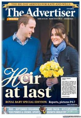
The Advertiser is a daily tabloid format newspaper based in the city of Adelaide, South Australia. First published as a broadsheet named The South Australian Advertiser on 12 July 1858, it is currently a tabloid printed from Monday to Saturday. The Advertiser came under the ownership of Keith Murdoch in the 1950s, and the full ownership of Rupert Murdoch in 1987. It is a publication of Advertiser Newspapers Pty Ltd (ADV), a subsidiary of News Corp Australia, itself a subsidiary of News Corp. Through much of the 20th century, The Advertiser was Adelaide's morning broadsheet, The News the afternoon tabloid, with The Sunday Mail covering weekend sport, and Messenger Newspapers community news. The head office was relocated from a former premises in King William Street, to a new News Corp office complex, known as Keith Murdoch House at 31 Waymouth Street.
The Division of Bonython was an Australian Electoral Division in South Australia between 1955 and 2004. In its final configuration, it was based on the outer northern suburbs of Elizabeth, Munno Para, Parafield, Paralowie, Salisbury, Virginia, and to the town of One Tree Hill in Adelaide's outskirts. Bonython's first 14 years saw vast boundaries simultaneously cover as far north as Gawler, as far south as Magill Road at Norwood, and as far west as Ottoway. The seat would continue to cross south of Grand Junction Road until the creation of the Division of Makin at the pre-1984 redistribution.

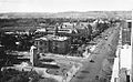
North Terrace is one of the four terraces that bound the central business and residential district of Adelaide, the capital city of South Australia. It runs east–west, along the northern edge of "the square mile". The western end continues on to Port Road, and the eastern end continues across the Adelaide Parklands as Botanic Road.
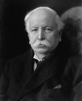
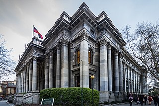
Sir John Langdon Bonython was an Australian editor, newspaper proprietor, philanthropist, journalist and politician who served as a member of the inaugural federal Parliament, and was editor of the Adelaide daily morning broadsheet, The Advertiser, for 35 years.
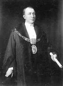
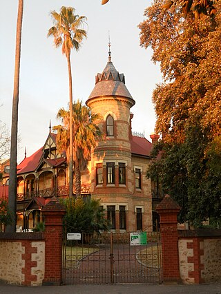
Sir John Lavington Bonython was a prominent public figure in Adelaide, known for his work in journalism, business and politics. In association with his father, he became involved in the management of newspapers including The Advertiser; he also served as editor of The Saturday Express and as a journalist. After The Advertiser was sold in 1929 and converted to a public company, he became a director, and for a time vice-chairman; an association that continued until his death. In 1901 he began a long association with the Adelaide City Council, serving as Mayor of Adelaide (1911–1913) and later as Lord Mayor of Adelaide (1927–1930). He was knighted in 1935. The now removed Lavington Bonython Fountain on North Terrace was erected in front of the SA Museum in his honour.
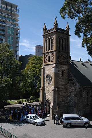
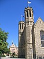
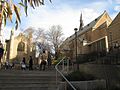
Trinity Church (also known as Holy Trinity Church Adelaide, is an Australian evangelical Anglican church located at 88 North Terrace in the city of Adelaide, South Australia. Trinity Church has five gatherings at the North Terrace location each Sunday, as well as various other meetings throughout the week.

Mount Bonython is one of two major peaks in the Adelaide Hills visible from Adelaide. The other, about a kilometre to the south and some 50 m higher, is Mount Lofty. Mount Bonython is named after Sir John Langdon Bonython and was previously known simply as Little Mount. There is a telecommunications tower used for the Telstra NextG network located at its summit.

Government House, located in Adelaide on the corner of North Terrace and King William Road, is the official residence of the governor of South Australia.
Parliament House, on the corner of North Terrace and King William Road in the Adelaide city centre, is the seat of the Parliament of South Australia. It was built to replace the adjacent and overcrowded Parliament House, now referred to as "Old Parliament House". Due to financial constraints, the current Parliament House was constructed in stages over 65 years from 1874 to 1939.

Adelaide city centre is the inner city locality of Greater Adelaide, the capital city of South Australia. It is known by locals simply as "the City" or "Town" to distinguish it from Greater Adelaide and from the City of Adelaide local government area. The population was 15,115 in the 2016 census.

Pulteney Street is a main road which runs north-south through the middle of the eastern half of the Adelaide city centre, in Adelaide, South Australia. It runs north-south from North Terrace, through Hindmarsh and Hurtle Squares, to South Terrace, where it becomes Unley Road. It is the only one of the city centre's major north-south thoroughfares that does not continue northwards over North Terrace.

The Jubilee 150 Walkway, also variously known as the Jubilee 150 Commemorative Walk, the Jubilee 150 Walk, Jubilee 150 Plaques, the Jubilee Walk, or simply J150, is a series of (initially) 150 bronze plaques set into the pavement of North Terrace, Adelaide from King William Street to Pulteney Street. It was officially opened on 21 December 1986. It was commissioned as part of the celebrations commemorating the 150th anniversary of the founding of the British Province of South Australia on 28 December 1836.
Hugh Reskymer "Kym" Bonython, was an Australian politician, World War Two veteran, musician, gallery owner, and racing driver.

Grenfell Street is a major street in the north-east quarter of the Adelaide city centre, South Australia. The street runs west-east from King William Street to East Terrace. On the other side of King William Street, it continues as Currie Street. Its intersection with Pulteney Street is encircled by Hindmarsh Square.

Pulteney Grammar School is an independent, Anglican, co-educational, private day school. Founded in 1847 by members of the Anglican Church, it is the second oldest independent school in South Australia. Its campuses are located on South Terrace in Adelaide, South Australia.

The Torrens Building, named after Sir Robert Richard Torrens, is a State Heritage-listed building on the corner of Victoria Square and Wakefield Street in Adelaide, South Australia. It was originally known as the New Government Offices, and after that a succession of names reflecting its tenants, including as New Public Offices, the Lands Titles Office, and Engineering & Water Supply Department. It has been home to a number of government departments for much of its existence.

Pilgrim Uniting Church is a church in the heart of the City on Flinders Street, Adelaide in South Australia. It is a church of the Uniting Church in Australia.
Carclew is a Federation style mansion built in 1897, located in the Adelaide suburb of North Adelaide, overlooking the Adelaide city centre city from Montefiore Hill. The name is now better known as the cultural organisation dedicated to artistic development of young people, now known simply as Carclew, which has been housed in the building since 1971.