
Adelaide railway station is the central terminus of the Adelaide Metro railway system. All lines approach the station from the west, and it is a terminal station with no through lines, with most of the traffic on the metropolitan network either departing or terminating here. It has nine below-ground platforms, all using broad gauge track. The station is located on the north side of North Terrace, west of Parliament House.

Rundle Mall is a pedestrian street mall located in Adelaide, South Australia. It was opened as a pedestrian mall in September 1976 by closing the section of Rundle Street between King William Street and Pulteney Street, to vehicular traffic. The street continues as Rundle Street to the east and Hindley Street to the west.

North Terrace is one of the four terraces that bound the central business and residential district of Adelaide, the capital city of South Australia. It runs east–west, along the northern edge of "the square mile". The western end continues on to Port Road, and the eastern end continues across the Adelaide Parklands as Botanic Road.

The Adelaide Park Lands comprise the figure-eight configuration of land, spanning both banks of the River Torrens between Hackney and Thebarton, which encloses and separates the City of Adelaide area from the surrounding suburbia of greater metropolitan Adelaide, the capital city of South Australia. They were laid out by Colonel William Light in his design for the city, and originally consisted of 2,300 acres (930 ha) "exclusive of 32 acres (13 ha) for a public cemetery". One copy of Light's plan shows areas for a cemetery and a Post and Telegraph Store on West Terrace, a small Government Domain and Barracks on the central part of North Terrace, a hospital on East Terrace, a Botanical Garden on the River Torrens west of North Adelaide, and a school and a storehouse south-west of North Adelaide.

King William Street is the part of a major arterial road that traverses the CBD and centre of Adelaide, continuing as King William Road to the north of North Terrace and south of Greenhill Road; between South Terrace and Greenhill Road it is called Peacock Road. At approximately 40 metres (130 ft) wide, King William Street is the widest main street of all the Australian State capital cities. Named after King William IV in 1837, it is historically considered one of Adelaide's high streets, for its focal point of businesses, shops and other prominent establishments. The Glenelg tram line runs along the middle of the street through the city centre.

Veale Gardens is part of the Adelaide Parklands throughout and surrounding the City of Adelaide. It is located in the South Parklands surrounded by Greenhill and Peacock Roads, South Terrace, and Sir Lewis Cohen Avenue. The gardens can be entered by entrances on South Terrace.

Rundle Street, often referred to as "Rundle Street East" as distinct from Rundle Mall, is a street in the East End of the city centre of Adelaide, the capital of South Australia. It runs from Pulteney Street to East Terrace, where it becomes Rundle Road through the East Park Lands. The street is close to Adelaide Botanic Gardens, Rundle Park, Rymill Park, Hindmarsh Square and North Terrace.
This is a timeline of Adelaide history.

Brisbane City is the central suburb and central business district of Brisbane, the state capital of Queensland, Australia. It is colloquially referred to as the "Brisbane CBD" or "the city". It is located on a point on the northern bank of the Brisbane River, historically known as Meanjin, Mianjin or Meeanjin in the local Aboriginal Australian dialect. The triangular shaped area is bounded by the median of the Brisbane River to the east, south and west. The point, known at its tip as Gardens Point, slopes upward to the north-west where the city is bounded by parkland and the inner city suburb of Spring Hill to the north. The CBD is bounded to the north-east by the suburb of Fortitude Valley. To the west the CBD is bounded by Petrie Terrace, which in 2010 was reinstated as a suburb.

Rymill Park / Murlawirrapurka, and numbered as Park 14, is a recreation park located in the East Park Lands of the South Australian capital of Adelaide. There is an artificial lake with rowboats for hire, a café, children's playground and rose garden, and the Adelaide Bowling Club is on the Dequetteville Terrace side. The O-Bahn passes underneath it, to emerge at the western side opposite Grenfell Street.

Adelaide city centre is the inner city locality of Greater Adelaide, the capital city of South Australia. It is known by locals simply as "the City" or "Town" to distinguish it from Greater Adelaide and from the City of Adelaide local government area. The population was 15,115 in the 2016 census.

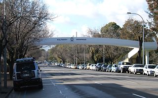
Pulteney Street is a main road which runs north-south through the middle of the eastern half of the Adelaide city centre, in Adelaide, South Australia. It runs north-south from North Terrace, through Hindmarsh and Hurtle Squares, to South Terrace, where it becomes Unley Road. It is the only one of the city centre's major north-south thoroughfares that does not continue northwards over North Terrace.

The Myer Centre is a five level shopping centre in the heart of the Adelaide city centre situated along the Rundle Mall shopping precinct and North Terrace. It is owned by Starhill Global REIT and managed by CBRE.

Hutt Street is the easternmost of the five major north–south roads running through the City of Adelaide. It runs from Pirie Street to South Terrace, from where it continues south as Hutt Road. Flanked by leafy side streets with many late 19th-century dwellings, it is home to a wide range of restaurants, two pubs, shops, offices and professional and medical suites.

Grenfell Street is a major street in the north-east quarter of the Adelaide city centre, South Australia. The street runs west-east from King William Street to East Terrace. Its intersection with Pulteney Street is formed by Hindmarsh Square. On the west side of King William Street, it continues as Currie Street towards West Terrace.
East Terrace is a road that marks the eastern edge of the Adelaide city centre in Adelaide, South Australia.
South Terrace is one of the four terraces which bound the city centre of Adelaide, the capital of South Australia.
Waymouth Street, often spelt as Weymouth Street in the early days, is an east–west street running between King William Street and West Terrace in the Adelaide city centre in South Australia. The street is named after Henry Waymouth, a founding director of the South Australian Company, whose name was also sometimes spelt as Weymouth.

Frome Street is a street in the East End of the Adelaide city centre, South Australia. It runs from North Terrace in the north to Angas Street, and then as Regent Street North to Carrington Street in the south. North of North Terrace, Frome Street continues towards North Adelaide as Frome Road.

Gawler Place is a single-lane thoroughfare in the city centre of Adelaide, the capital of South Australia. Somewhat narrower than other busy streets in the Central Business District, it runs north to south from North Terrace to Wakefield Street, parallel to and approximately midway between King William and Pulteney streets.


